


Last winter was one for the record books along the Front Range, and not in a good way. The first flakes arrived weeks late, setting records in spots. The heart of winter brought a six-week stretch without a single accumulating snow anywhere from Fort Collins to Castle Rock. Some of the season’s biggest storms waited until March and May. And when it was all over, cities up and down the Urban Corridor had picked up only about half their normal snow, with Boulder posting its worst season in 45 years.
A winter that strange is a tough one to forecast. So before this season’s first flakes fly, we went back and graded ourselves: every snowfall forecast we issued last winter, 16 storms, 30 towns from Estes Park to Parker, more than 400 forecasts in all.
The verdict? Better than you might expect in a winter that broke all the rules. But not perfect. One March storm caught us flat-footed across the southern Metro area, one city gave us more trouble than any other, and there’s a clear pattern in the forecasts we missed that’s already shaping how we’ll approach this winter.
Want to know how we did in your town? Read on as we go through every forecast we made against every inch that fell, and summarize everything in a few handy charts.

Go Premium, get all the perks.
Daily Forecast Updates
Get our daily forecast discussion every morning delivered to your inbox.
All Our Model Data
Access to all our Colorado-centric high-resolution weather model graphics. Seriously — every one!
Ski & Hiking Forecasts
6-day forecasts for all the Colorado ski resorts, plus more than 120 hiking trails, including every 14er.
Smoke Forecasts
Wildfire smoke concentration predictions up to 72 hours into the future.
Exclusive Content
Weekend outlooks every Thursday, bonus storm updates, historical data and much more!
No Advertisements
Enjoy ad-free viewing on the entire site.
Purpose of this Recap
With a new snow season about to get going (we hope), there’s no better time to look back one last time at the historically bad winter we just endured, and to grade ourselves before the flakes start flying again.
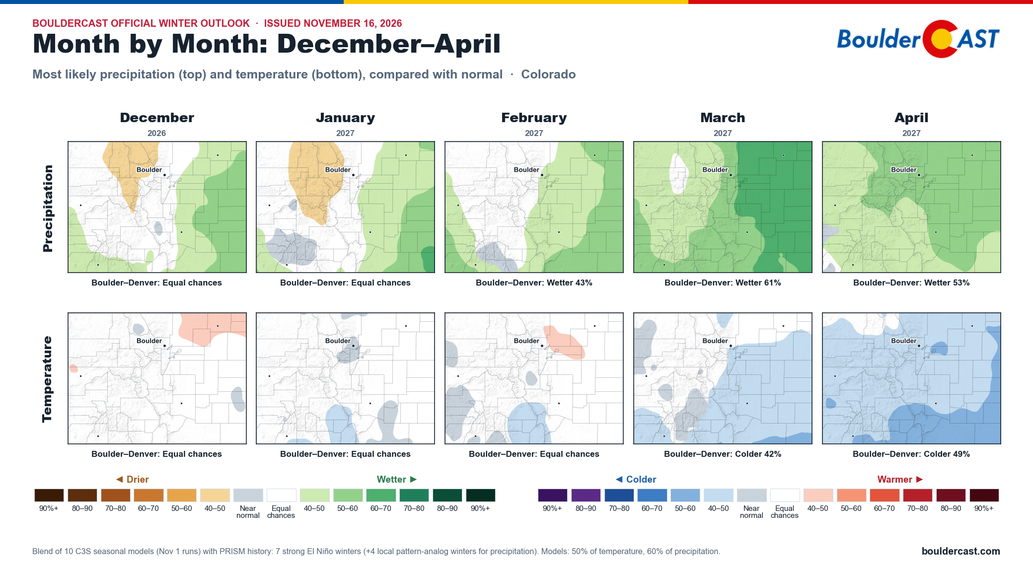
And once again, they’re taking their sweet time. As of mid-November, Boulder and Denver still haven’t recorded their first measurable snow of the season. By now we’d normally have about a foot of white on the books. Last winter’s first snow didn’t arrive until November 29th, the latest on record, and after a bone-dry first half of November that record is suddenly within reach again this year. However, the second of two Pacific storms moving into Colorado this week could finally put an end to the wait. Either way, a potentially historic Super El Niño has this winter looking very different from the last one, at least on paper. If you missed our deep dive into what that could mean for the Front Range, you can find it here. Spoiler: Winter may start slow but things should take a much wetter and snowier turn heading into the spring.
Furthermore, we won’t rehash how dismal last winter was across Colorado and the broader West here. We covered that in depth last spring. This post focuses only on Front Range snow events and how they played out in our immediate area.
After every winter, a good forecaster should review how the snow season unfolded and how their snowfall forecasts compared with what actually happened. That’s what we’re doing here: highlighting the successes and identifying the pain points so we can sharpen our approach for the winter ahead. It should also help you understand what goes into a snow forecast and how far you can trust our forecasts in your specific location.
Forecasting Challenges in the Front Range
Forecasting snow along the Front Range is never simple. It’s a terrain-heavy puzzle, often complicated by backdoor cold fronts, localized jet-forced snow bands, quick flips from upslope to downslope, mid-storm changes from rain to snow, warm ground, occasional blizzard conditions or barrier jets, and plenty of situations where a 50-mile shift in the storm track changes everything.
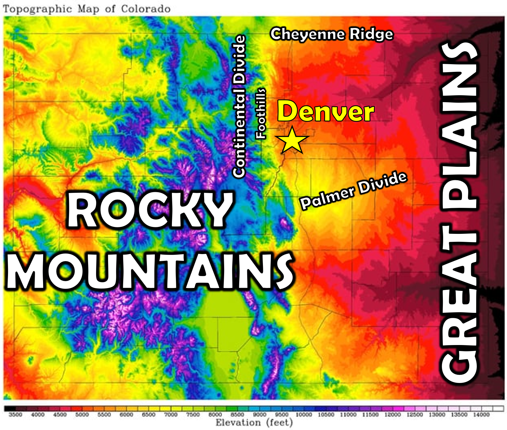
The Front Range’s geography plays an outsized role in every snowstorm that comes through. We sit where the Great Plains meet the Foothills, a narrow zone where small changes in wind direction, temperature or storm track can dramatically change snowfall. Even with so little snow, this winter showed that again and again. Marginal-temperature setups swung between rain, slush and heavy snow within hours. Upslope events produced jackpots in the Foothills while areas just a few miles east saw modest totals. And several storms reminded us how sensitive Boulder and Denver are to subtle adjustments in the jet stream and the broader synoptic pattern.
A Record Late Start to the Snow Season
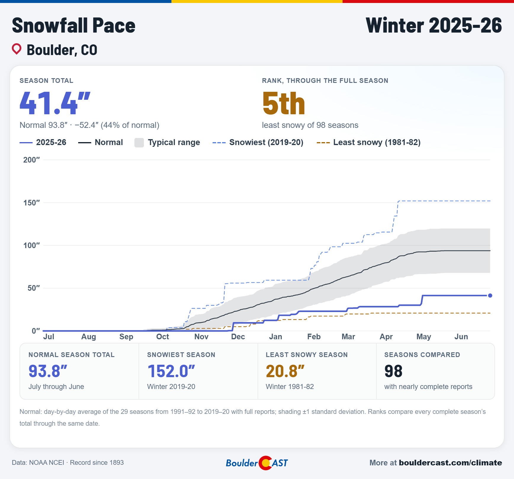
The winter had a clear warm and dry rhythm, broken only briefly by cold and snow. It generally felt more like fall, with only a few days of true winter mixed in. The result was one of the worst snow seasons on record for many Front Range cities, including Boulder and Denver. Boulder received only 41.4 inches of snow, less than half of normal and the lowest since the 1980-81 winter (45 years ago). Denver received 33.1 inches, its lowest in nine years.

The cumulative seasonal snowfall graphic below for Boulder shows that the 2025-26 winter actually started out worse than the historic 1981-82 season, but turned the tables around the New Year and never looked back ending with more than 20 inches of separation.
The season began with a record-late first snow after a very warm and dry fall across Colorado. The first flakes, a piddly dusting, didn’t arrive until November 29th. That was Boulder’s latest first accumulating snow on record by nearly two weeks.
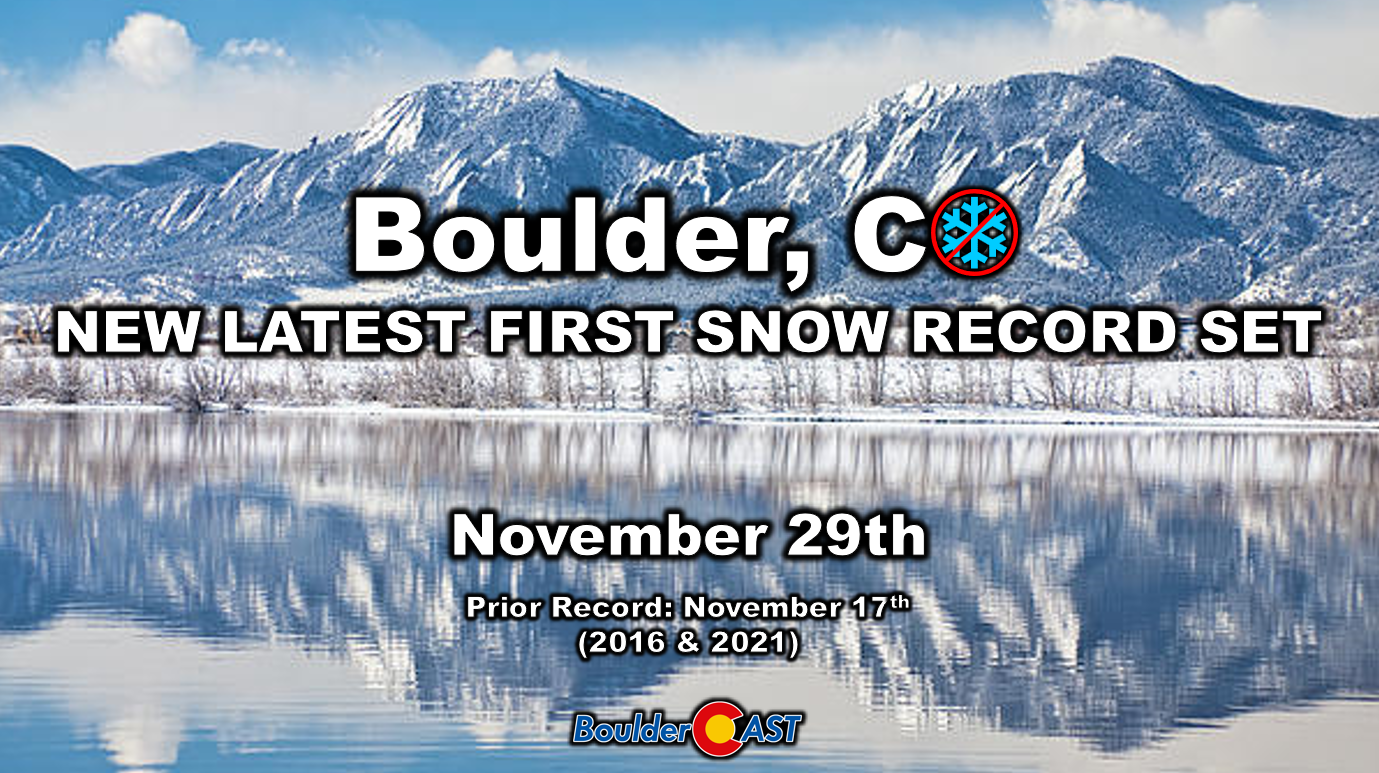
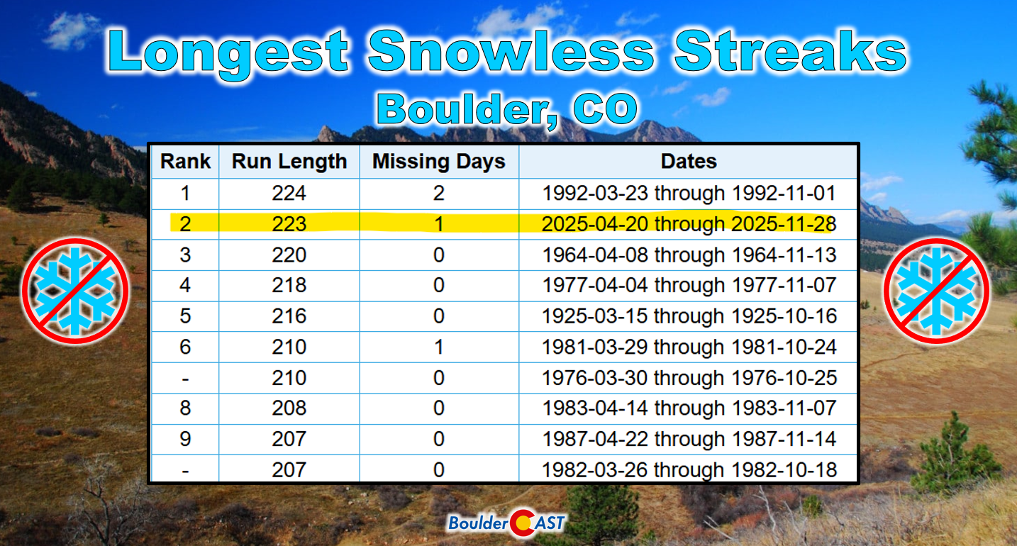
That late first snow brought us within one day of Boulder’s longest snowless streak on record: 223 consecutive days without snow.
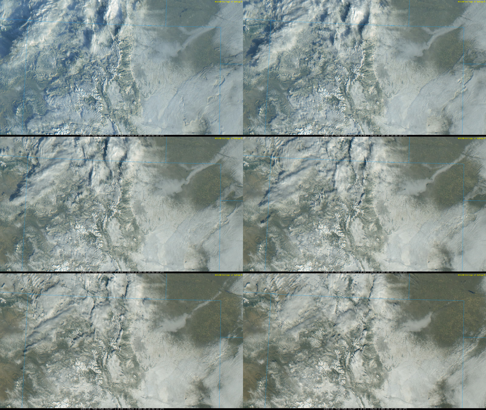
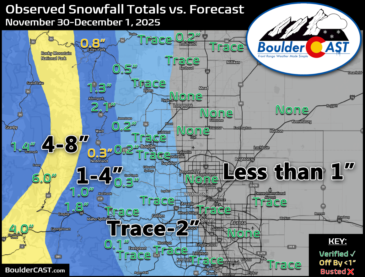
Most of the Front Range picked up a light dusting from this late November event, so the first snow was underwhelming but widespread. Our forecast for this very minor event turned out well, though a few Foothills locations overperformed slightly.

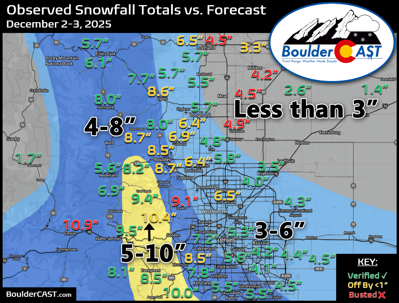
Just four days later, in early December, our first real snowstorm of the season arrived. A slow-moving Four Corners low dug in and combined intense upslope with other favorable ingredients as temperatures fell into the 20s. As the storm pulled out, most of the state was covered in a fresh and very welcome blanket of snow. Winter had finally shown up!
Our snowfall forecast for this event was pretty good overall. We correctly identified the sweet spot in the lower to middle Jefferson County Foothills and the lowest totals toward Weld County. Overall, the forecast ran an inch or so too low in several locations. Boulder officially recorded 9.1″ of snow, just above our 4-8″ forecast range.
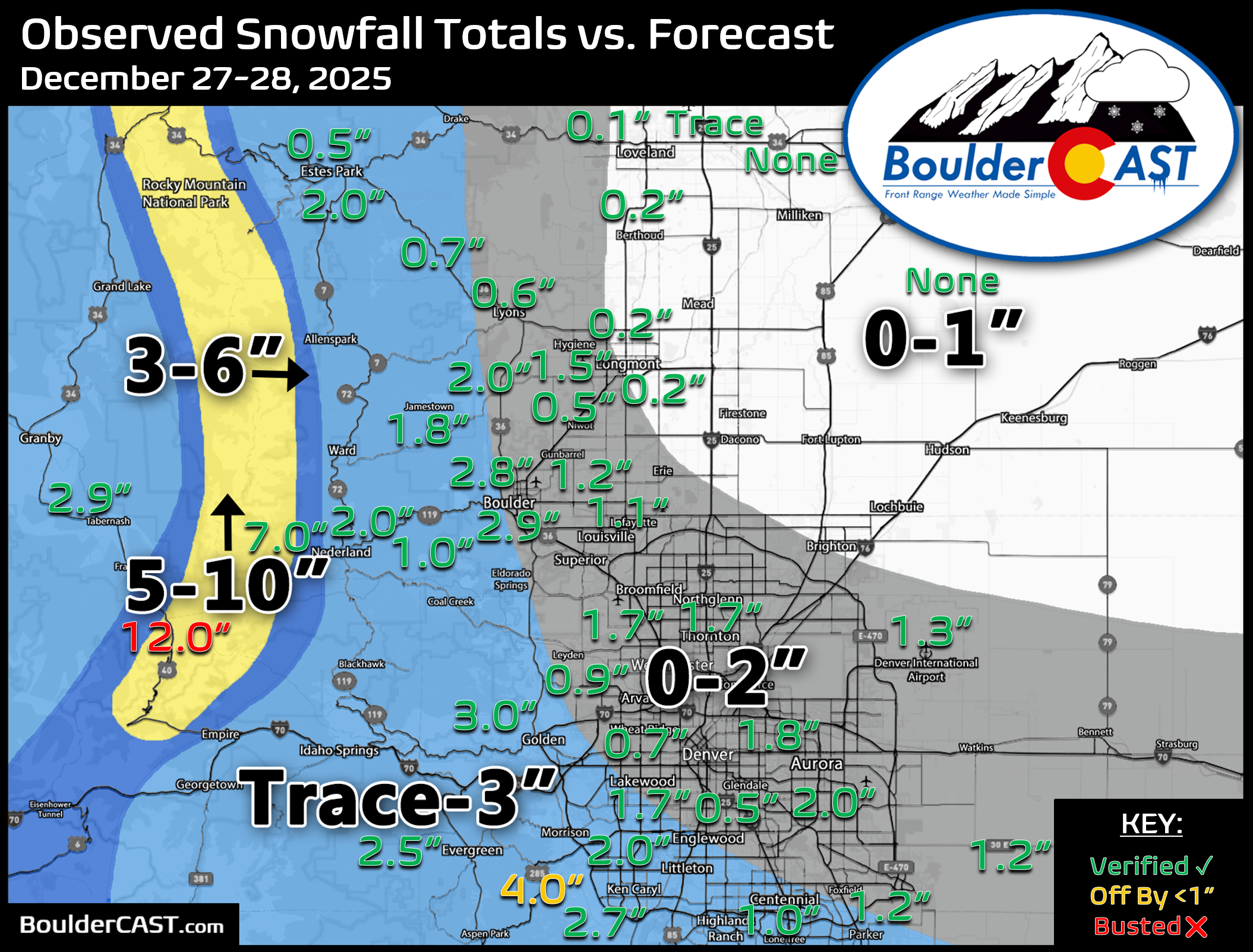
Our next snow event, and in fact our next precipitation event of any kind, didn’t come until more than three weeks later, just after Christmas. A few overnight jet-forced snow bands moved across the area, each lasting only a few hours. It was a completely brown Christmas in town, but it was nice to see a few holiday flakes, even if they were a couple of days late.
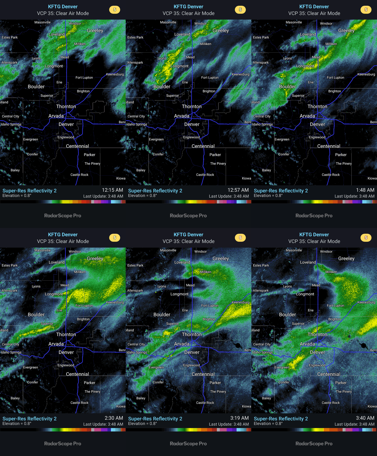
Going into that forecast, uncertainty was high about whether these quick-hitting bands would form over the Boulder-Denver area or get wiped out by the broader downslope pattern. We honestly weren’t sure whether the area would see no flakes at all or a couple of inches. It turned out to be the latter, with 2.9″ in Boulder and 1.3″ in Denver, and our Trace-to-3″ forecast verified well.

Actual Winter Feels in January!
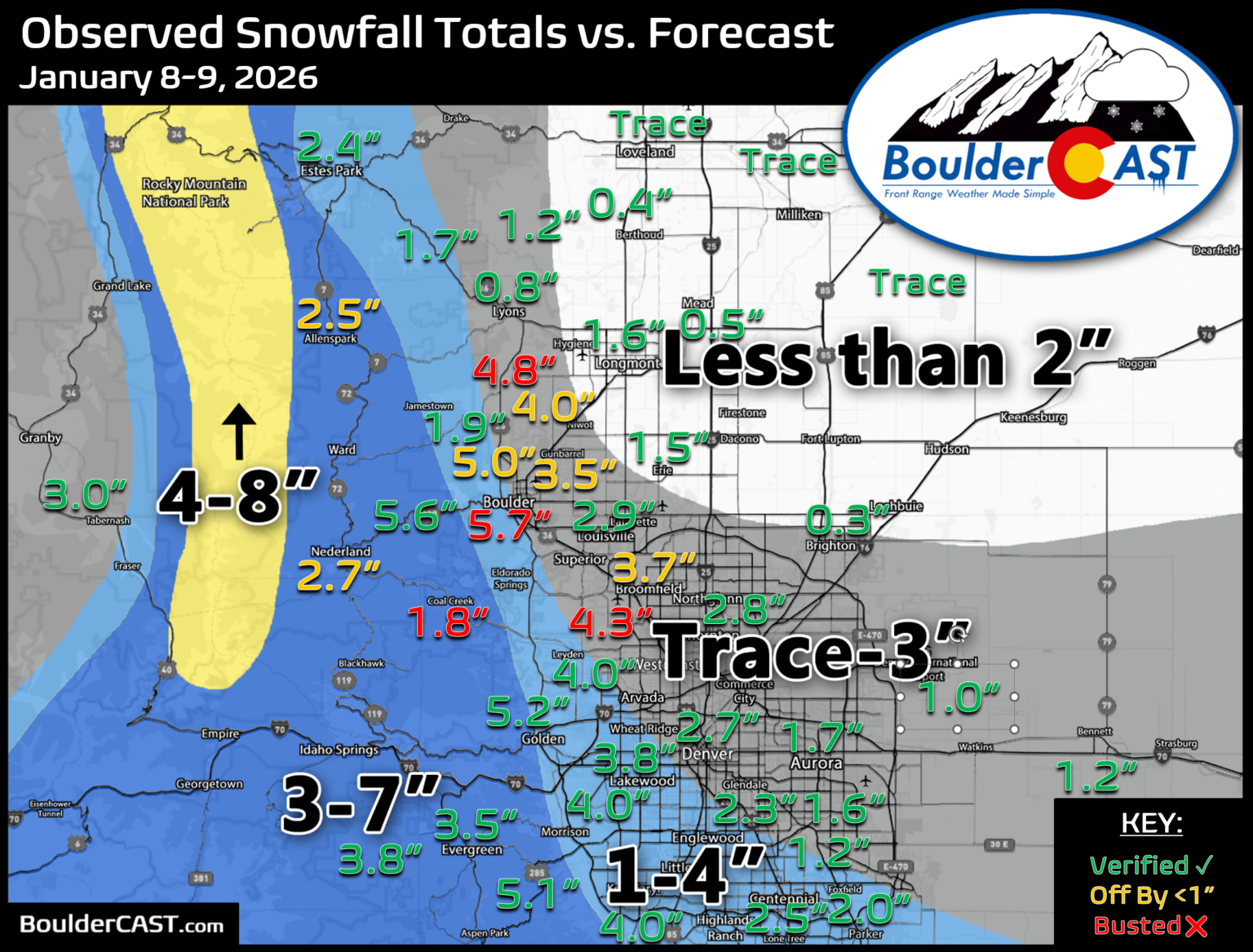
About ten days later, in early January, our next snowstorm arrived as two back-to-back low-pressure systems: one warm and moisture-rich from Baja California, the other colder and more dynamic out of western Canada.
The two storms came so close together that we’re treating them as a single snow event. Together they brought a few inches of snow to the Metro area. A couple of locally heavy bands from the second storm sent totals soaring in some places, including Boulder, where 6.0 inches fell. That was well above our 1-4″ forecast and our biggest miss of the season in Boulder.
Mid-to-late January brought the coldest stretch of the season, the only period that actually felt like winter. For about ten days, temperatures stayed mostly below normal. That stretch included Boulder’s only sub-zero reading of the winter, on the morning of January 26th.
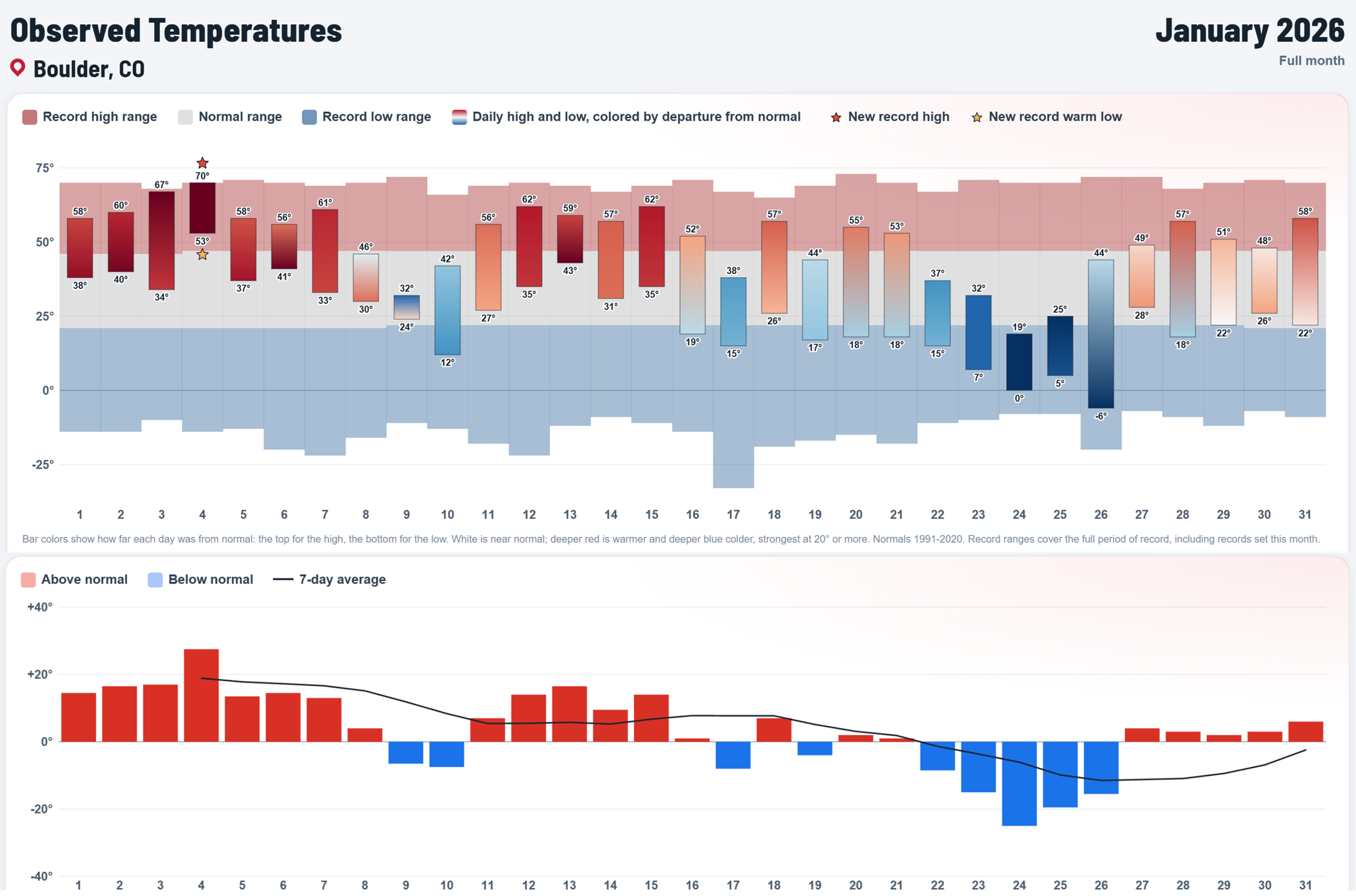
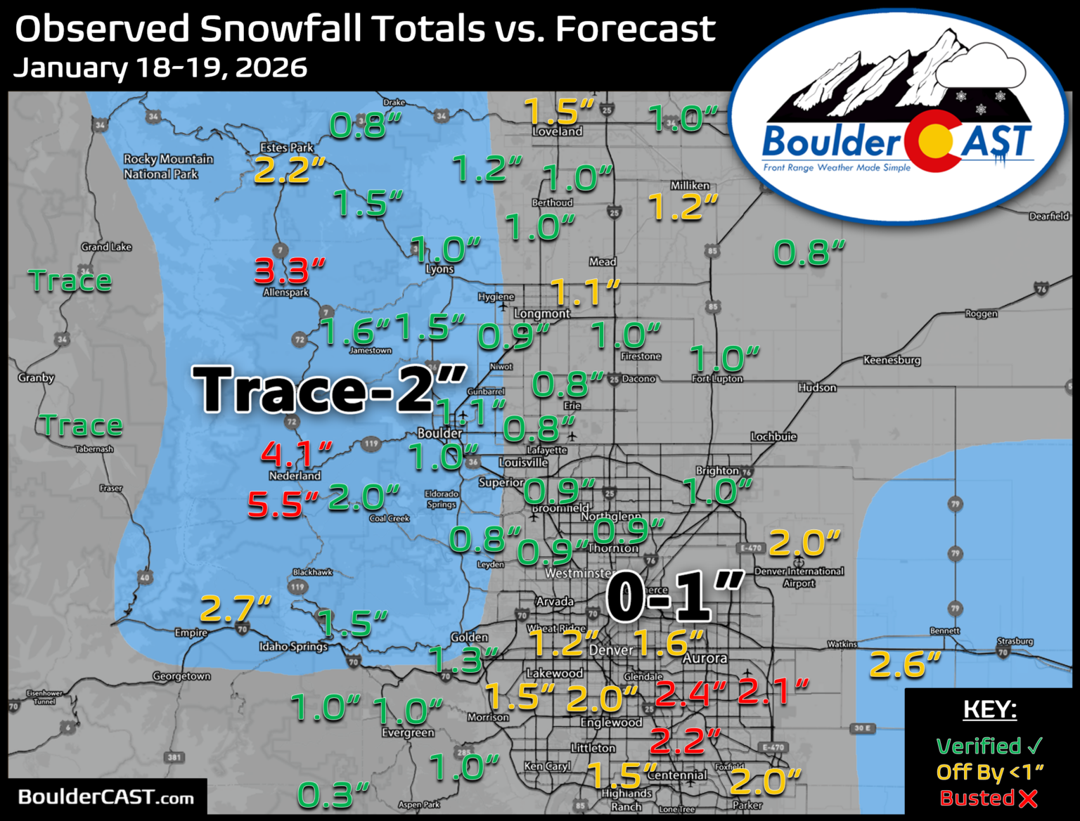
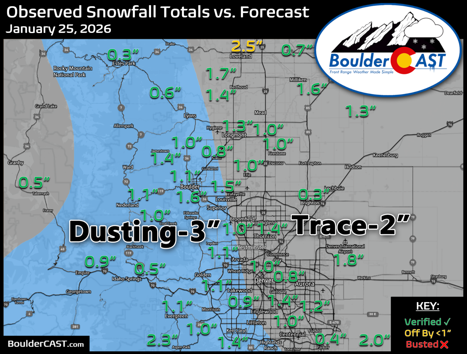
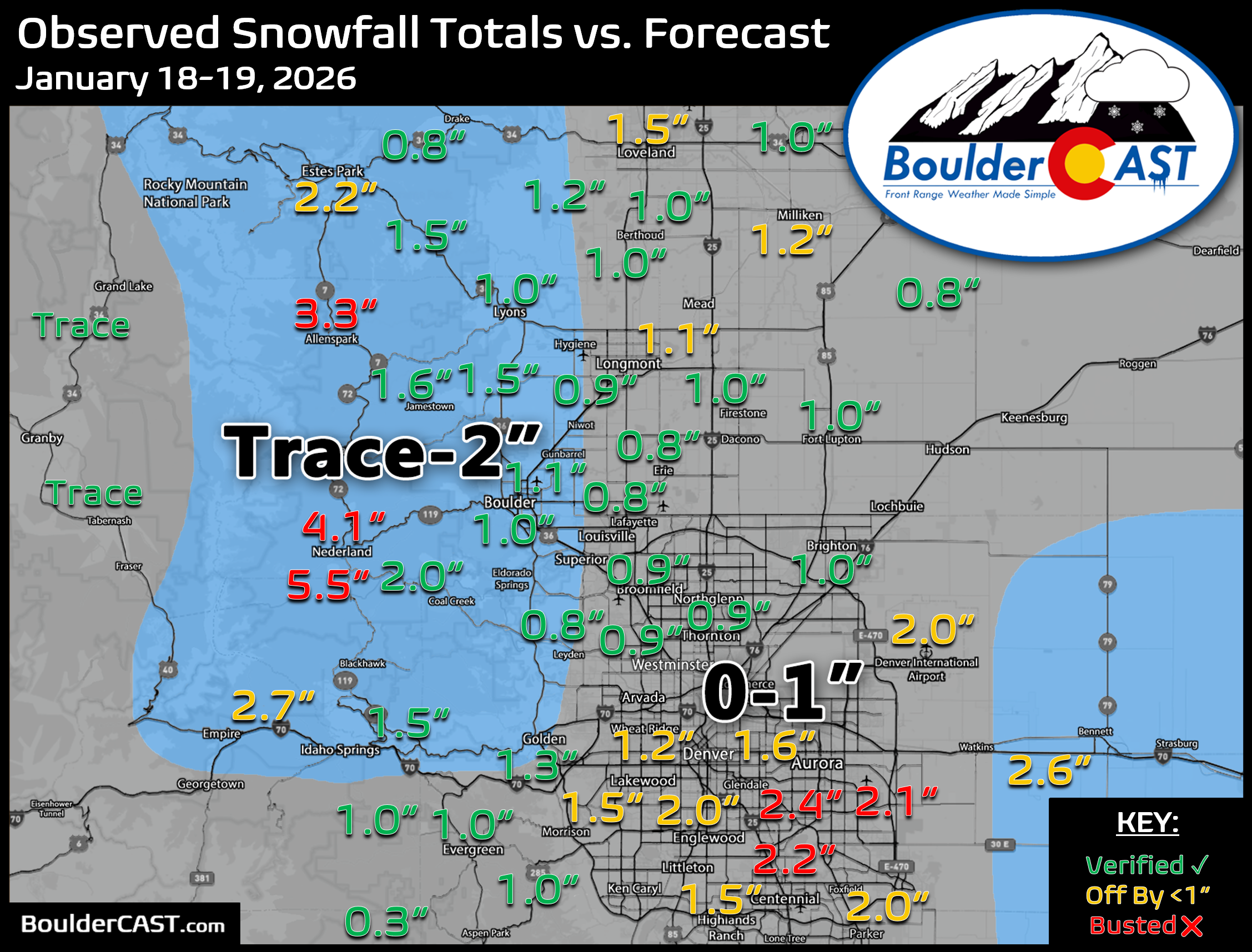
Several strong but moisture-starved cold fronts moved through during this time and produced three rounds of light snow (January 18-19, 23-24 and 25). Our forecasts for these small events were all acceptable, some better than others. Each event brought only 1 to 2 inches to the Boulder-Denver area, adding up to about 5 inches over the week. The Foothills saw 4 to 10 inches.

Extreme Fire Danger & Mountain Snow
About three weeks later, in mid-February, came our next snow event. Well, not technically. A strong, jet-driven Pacific storm carrying the remnants of an atmospheric river dropped 1 to 3 feet of snow on Colorado’s struggling Mountains. Farther east it was all downslope, with extremely dangerous fire weather across northeast Colorado and into the Great Plains.
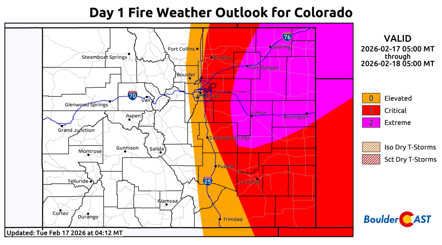
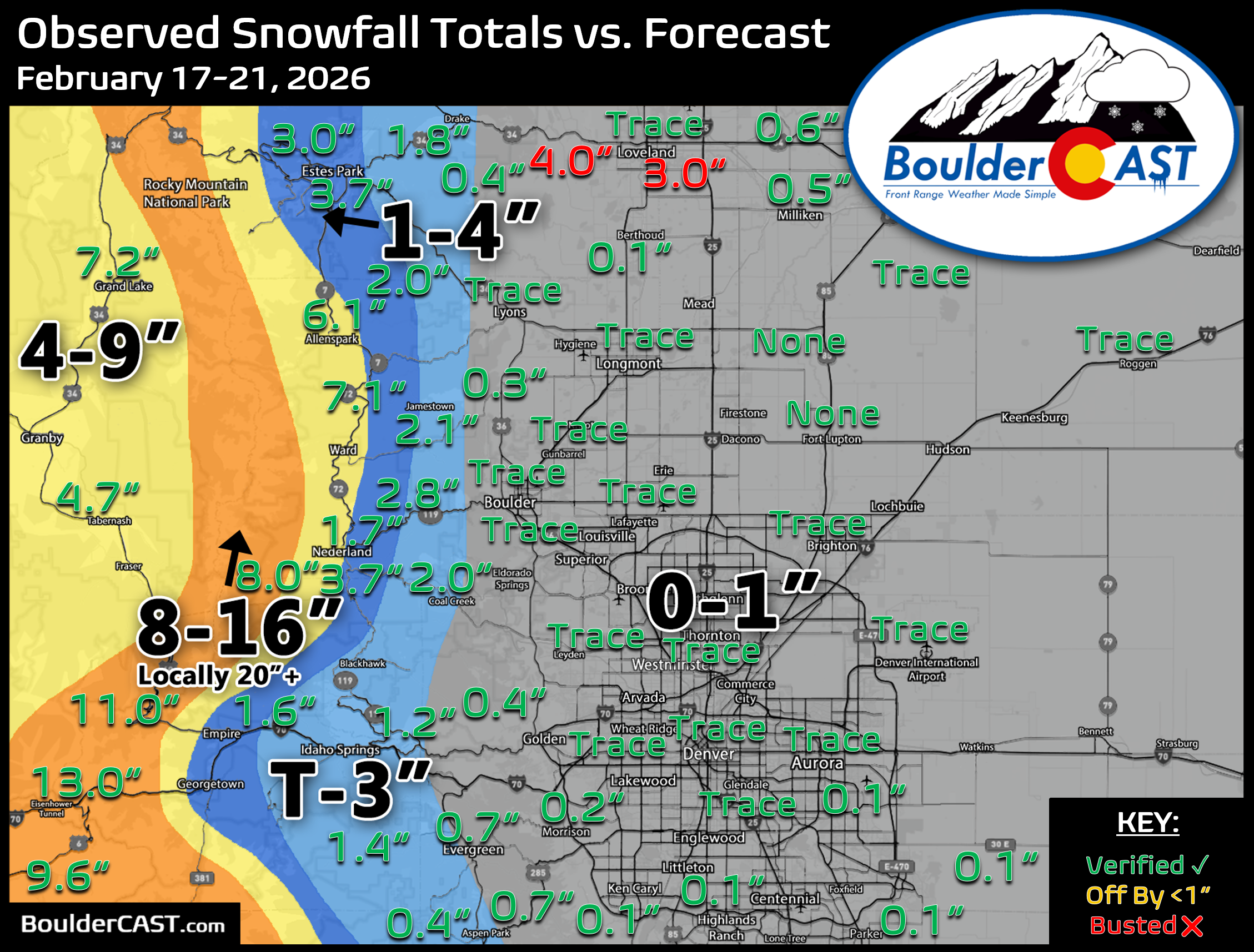
Our forecast for this event turned out pretty well. As expected, the lower elevations missed out almost entirely, with just a trace of snow in most places, while the Mountains picked up several inches to several feet.
Six-Week Snow Hiatus Ended in Early-March
After six weeks without accumulating snow in the heart of what is usually our snowiest season, flakes finally returned to the Front Range on March 6th. A slow-moving trough pushed into the Four Corners, stalled, and then split off a closed low toward Baja California.
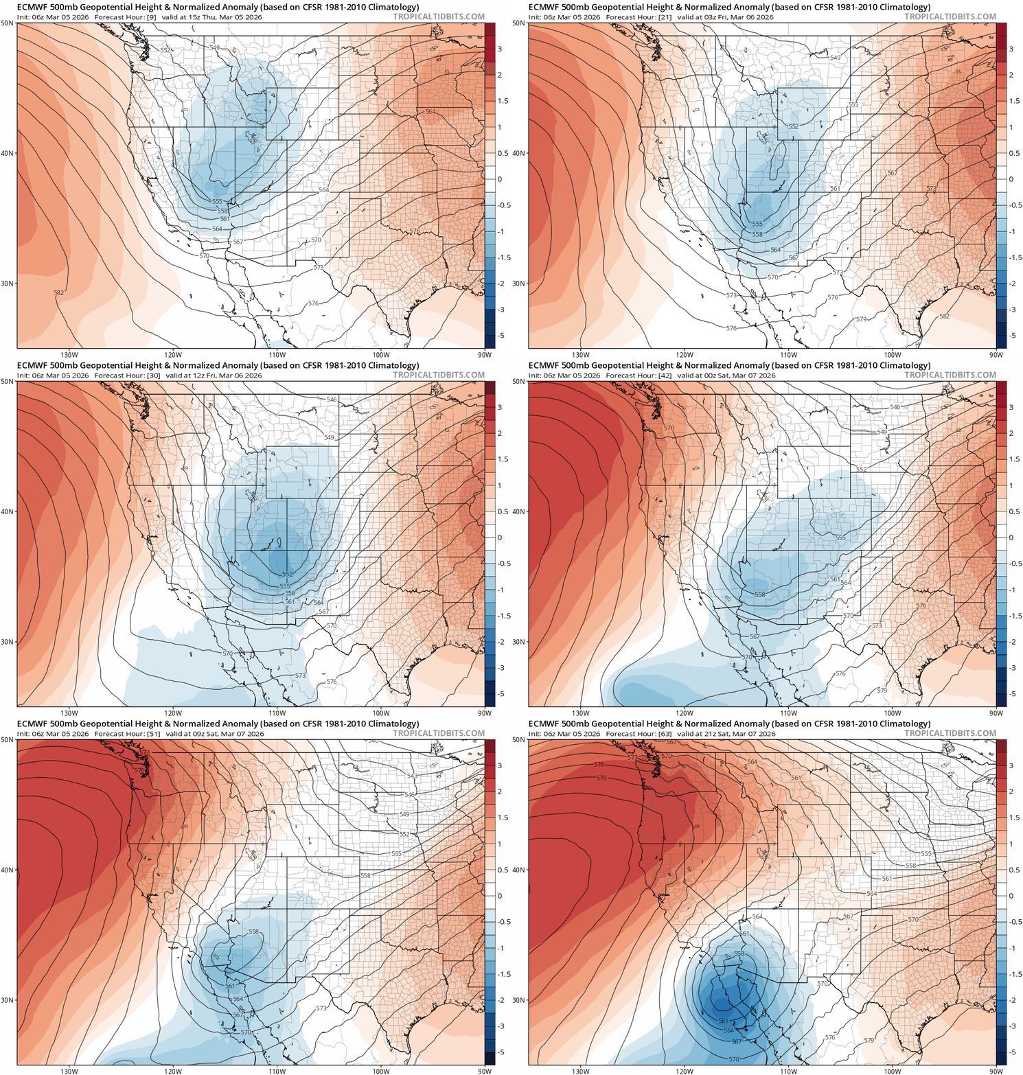
The trough did bring winter back to the Front Range, and the cold NNE upslope and healthy moisture verified well. The dramatic mid-storm split was the main source of uncertainty. Our biggest challenges were the tight north-south gradient around Boulder, a downslope-induced warm pocket off the Cheyenne Ridge, and how much melting would hold down lower-elevation totals despite steady snowfall.
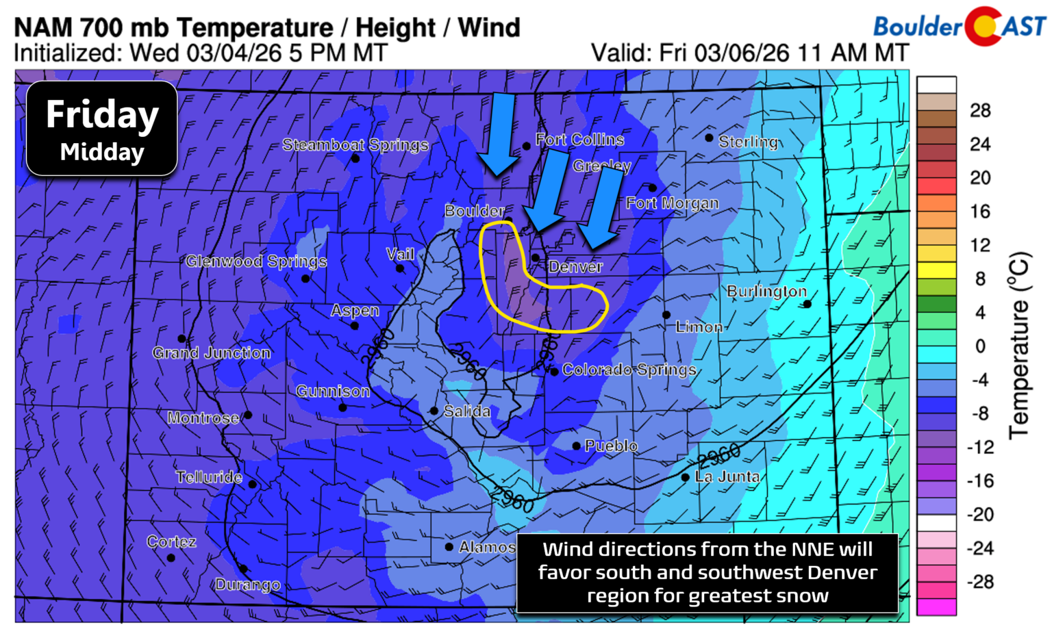
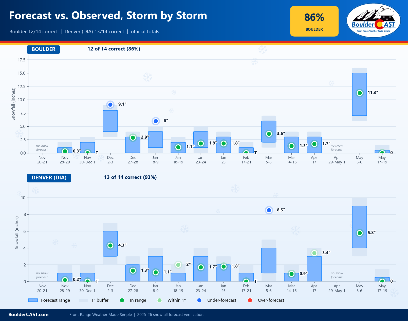
Overall the storm delivered the meaningful moisture we expected, but the sensitive temperature profile and small-scale terrain effects made the accumulation forecast especially tricky. Heading into the event, higher totals became increasingly likely, showing up in nearly every short-range model and some ensemble guidance. We raised our totals, but not enough. The favored areas south and southwest of Denver piled up 6 to 12 inches from DIA to Littleton, Aurora and Highlands Ranch. It was a surprise boomer and ended up being the season’s biggest storm in those places. Denver officially recorded 8.5″, more than double the top of our 1-4″ forecast range. Elsewhere our forecast worked out well, with 3.6″ officially in Boulder, within our 2-6″ range. The well-forecast intrusion of warm air from the north held totals from Gunbarrel to Longmont to a wet coating on the grass.

The big winner was Eldora, which picked up a season-high 18 inches.
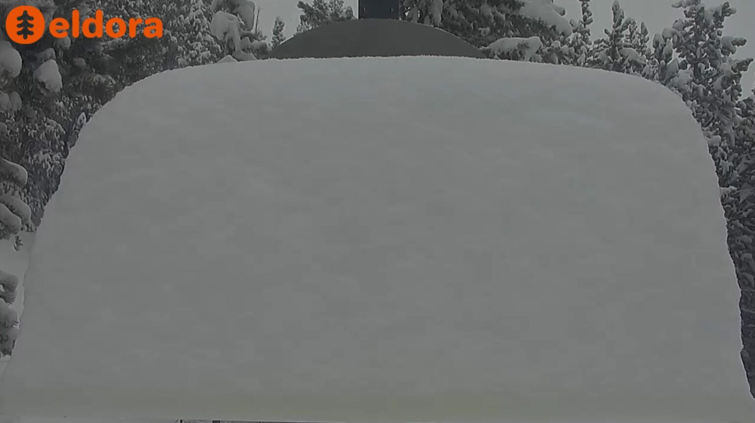
Eldora Snow Stake, late in the day Friday March 6, 2026
Spring Tried to Make Up for Lost Time
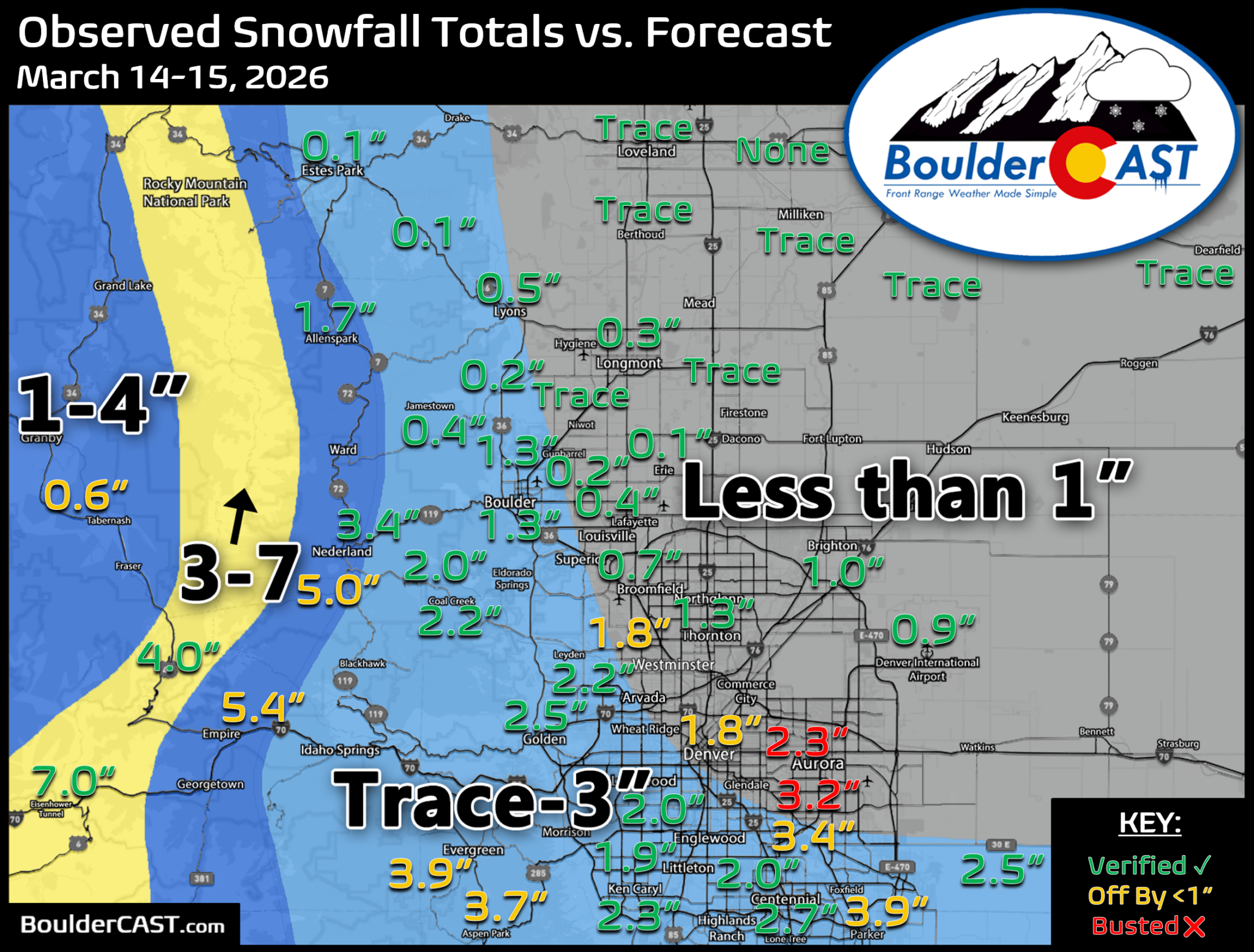
Just over a week later, on March 14-15, a fast-moving system gave us a two-part wintry event. A windy Saturday came first, with enough fire danger to prompt planning for a preemptive Xcel power shutoff. Then a strong cold front arrived around 1:30 AM on a Sunday. Temperatures dropped about 20 degrees, and several bands of heavy, convective snow showers swept across the Metro area before sunrise.
The wind half of the forecast was a flop. Gusts of 45 to 60 MPH lasted only about 90 minutes in Boulder and Jefferson Counties, peaking at 59 MPH at NCAR around 6 PM. Most other locations peaked at 30 to 50 MPH, and cooler, moister air arrived early enough to keep Red Flag conditions from developing. The snow half verified pretty well. Boulder officially measured 1.3″ and Denver 0.9″, both within our forecast ranges, though 2 to 4 inch totals were more widespread across parts of Denver than we expected. Loveland picked up 7 inches and Eldora 5.
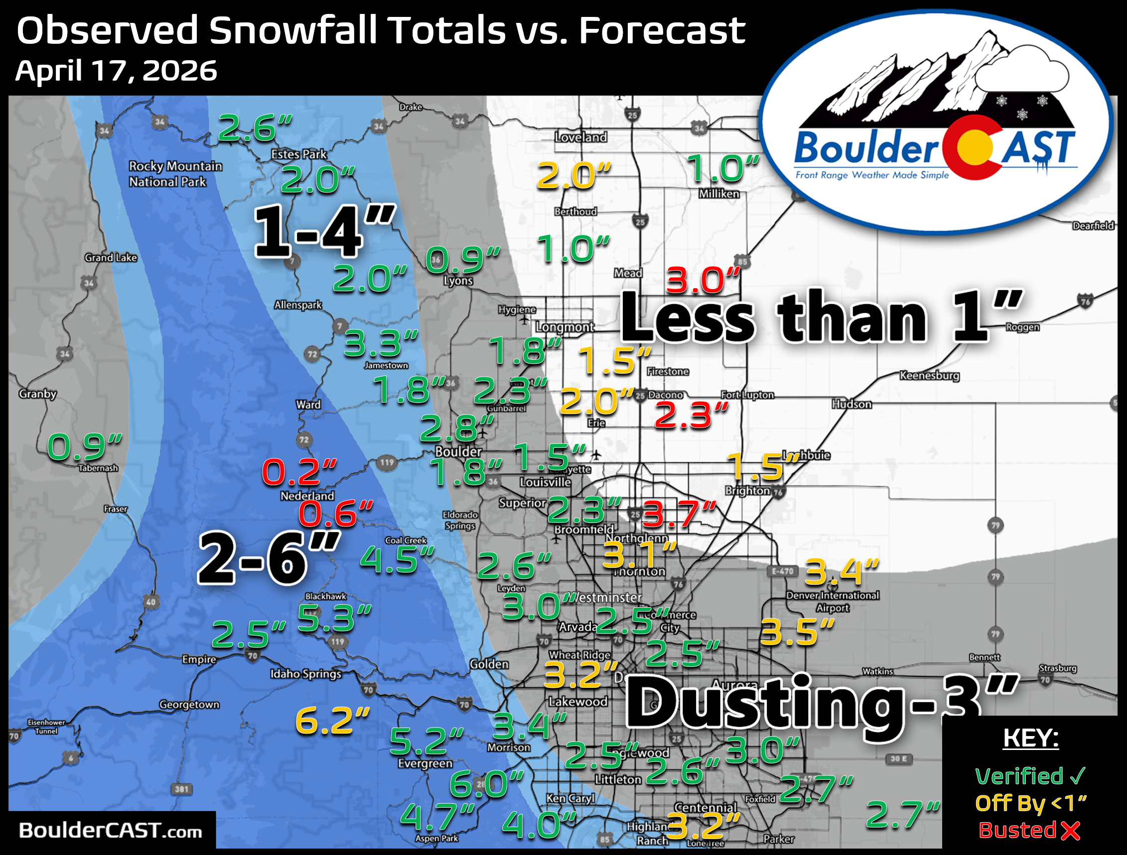
After another month of historically, dry and windy weather, April 17th brought one of the sharpest turnarounds of the season. That afternoon had highs in the mid-to-upper 70s with fire danger which gave way to a strong cold front just after midnight. The next day’s afternoon temperatures ran 40 to 45 degrees colder. Snow arrived a few hours later than expected, around 10 to 11 AM. It started slowly through a dry layer near the surface, then became moderate to heavy and wet once that layer saturated, and it kept falling for three to five hours before northwest downslope winds dried things out and brought sunshine before sunset.
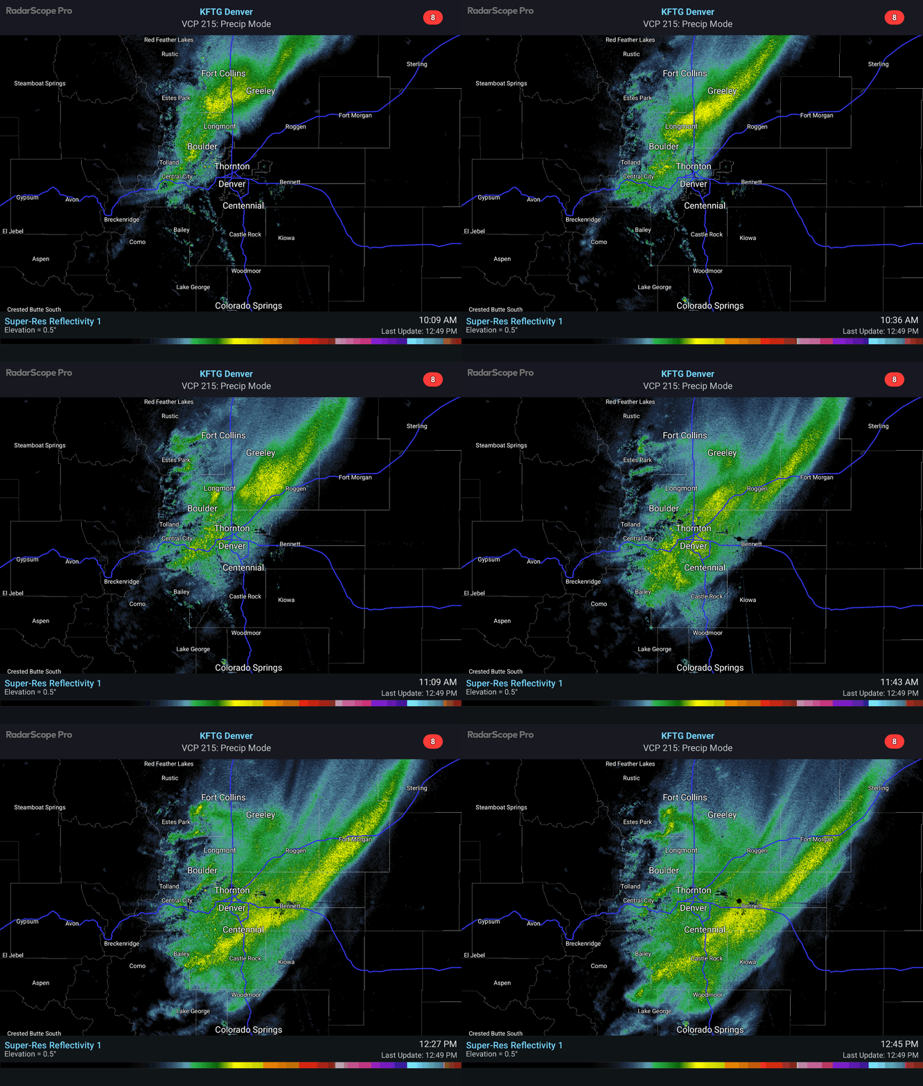
Our forecast for this one was fine. We correctly flagged the Jefferson County Foothills as the hotspot, but we expected noticeably less snow north and northeast of Boulder and Denver than actually fell. The bands didn’t discriminate much, and nearly everyone got a few hours of heavy snow and at least 1 to 2 inches. Boulder received 1.7″ and Denver 3.4″ against a Dusting-to-3″ forecast for both, while the Foothills mostly stayed under 6 inches. Warm ground and the strong April sun melted much of it within hours, and the hard freeze that followed was milder than first forecast.

The final days of April brought a slow-moving, moisture-rich storm that delivered a soaking to southern Colorado. As we expected, the Boulder-Denver area sat on the northern edge of the moisture plume. We picked up a bit of rain, but no snow in town, and snow was limited to the higher terrain.

A Grand Finale in May
Fittingly for this strange, upside-down winter, the biggest snowstorm of the season didn’t arrive until May 5th and 6th. A closed low over California pulled Pacific moisture in, then merged with a cold northern-stream trough from western Canada. That produced about 36 hours of precipitation and a long stretch of strong east-northeast upslope aimed squarely at Boulder and Larimer Counties. Rain fell first, then turned to heavy, wet snow Tuesday evening as temperatures crashed. With trees nearly fully leafed out, the main concern from the start was widespread limb breakage and power outages, not just snow totals.
GOES-East water vapor animation from May 6, 2026 showing the two waves phasing over Colorado
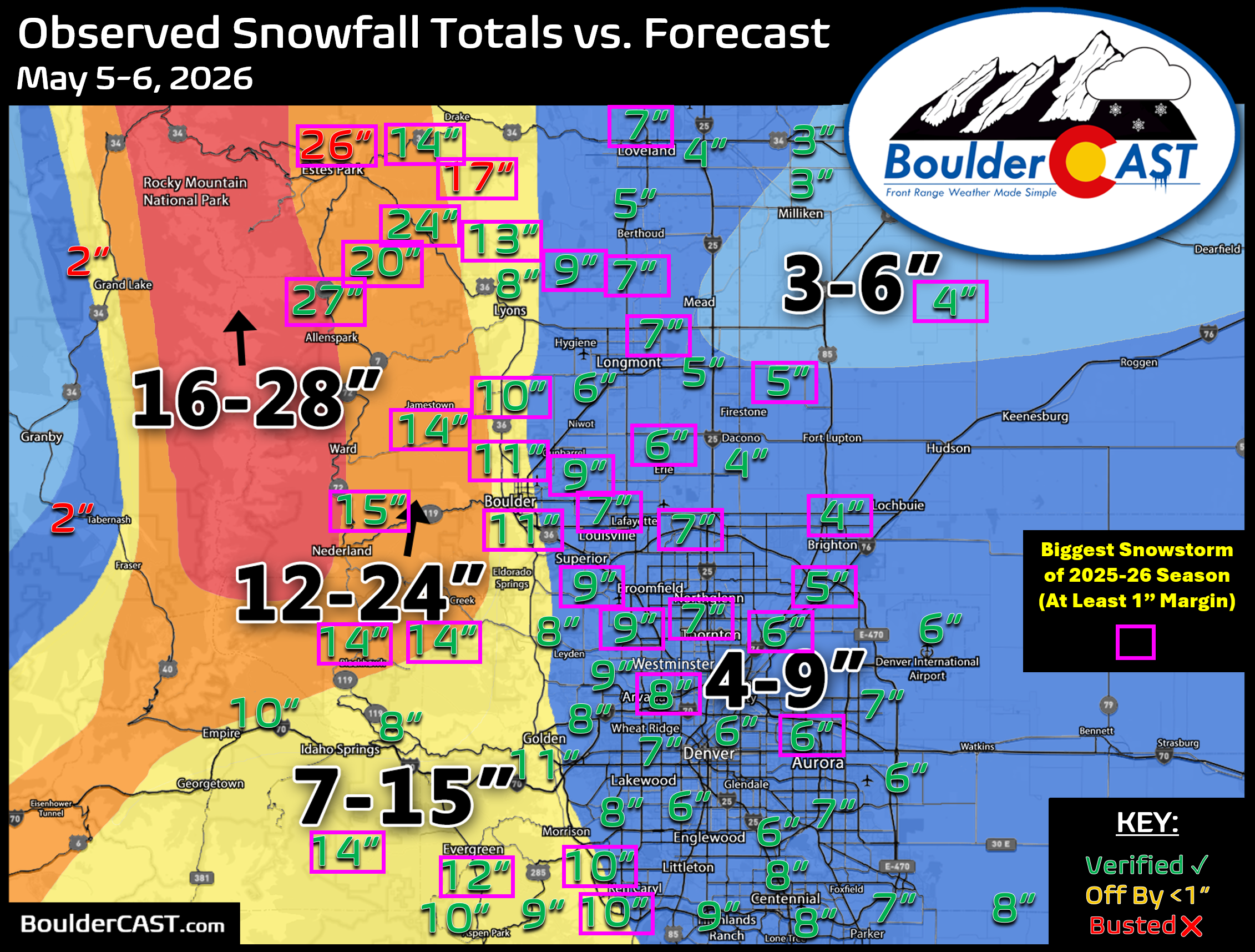
This was one of our better forecasts of the season. Boulder officially recorded 11.3″ of concrete, well within our 7-15″ forecast. Denver received 5.8″, in the middle of our 4-9″ range, and parts of the Foothills topped two feet. Short-range models ran roughly 25% wetter than global guidance in the lead-up, and our decision to lean toward the wetter solutions while accounting for melting paid off. Unfortunately, the tree damage and outages we warned about also happened.
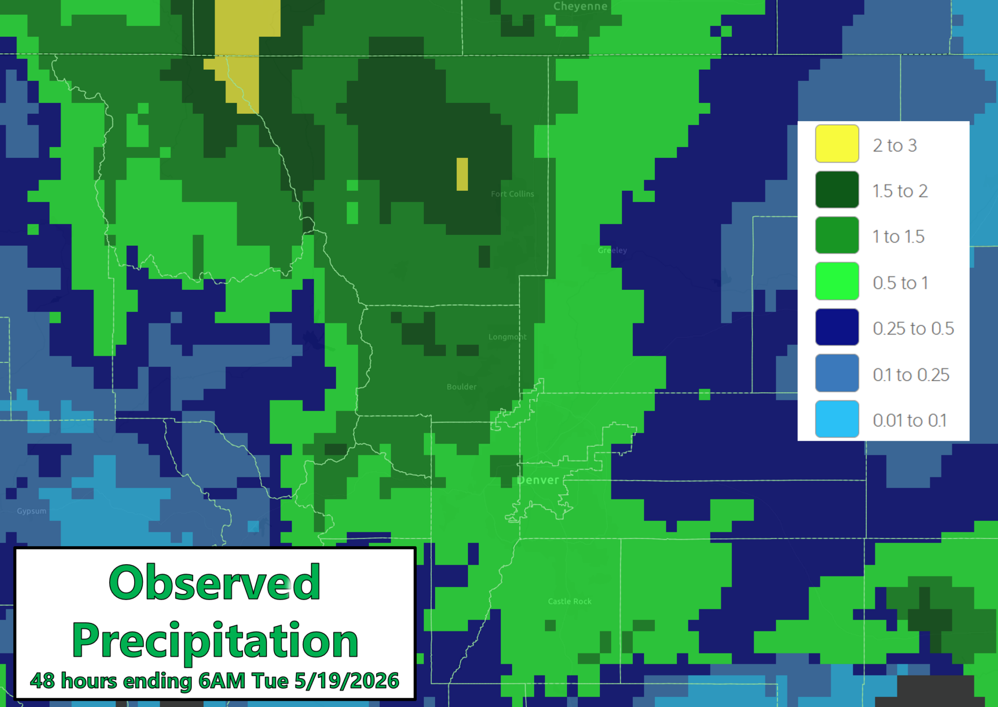
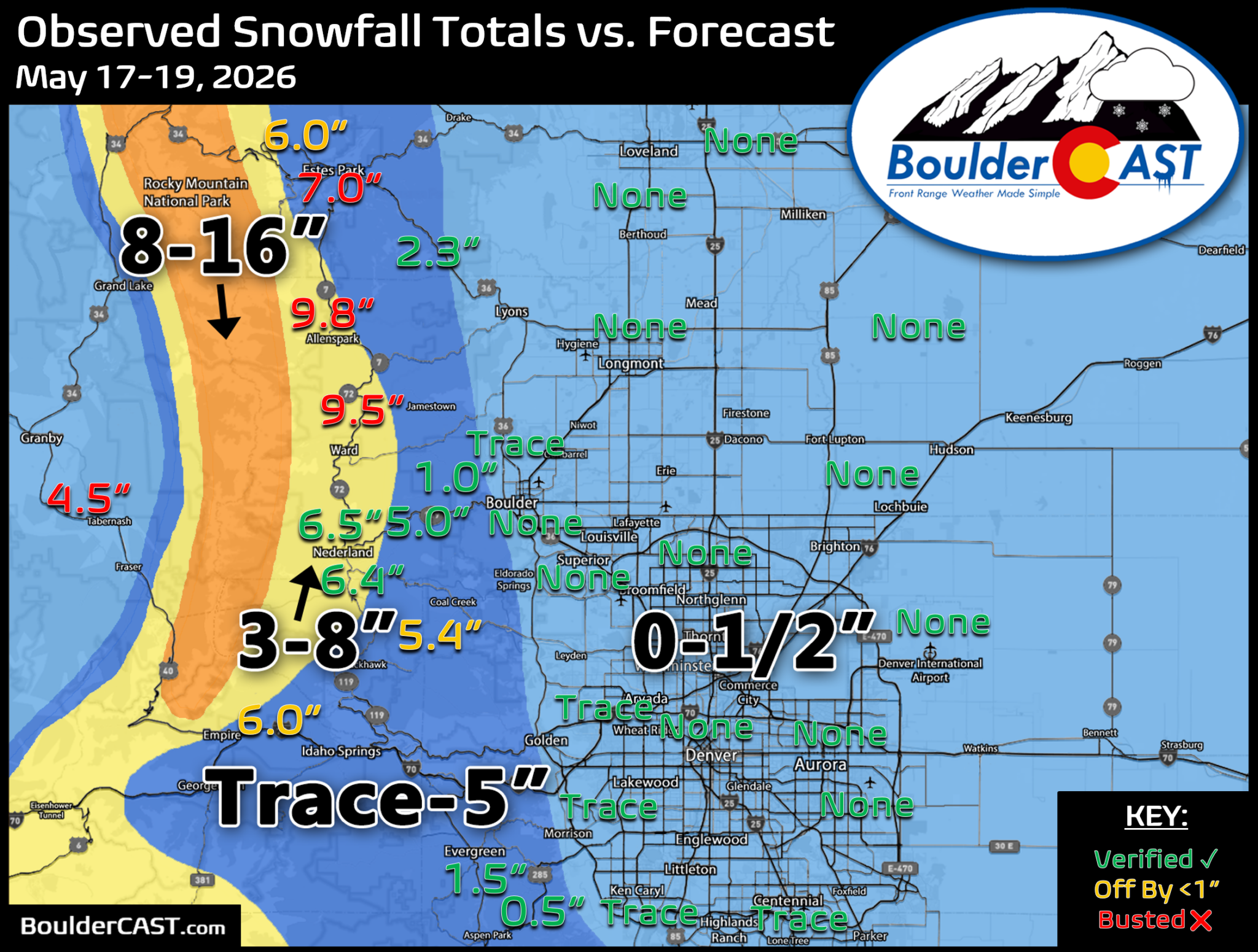
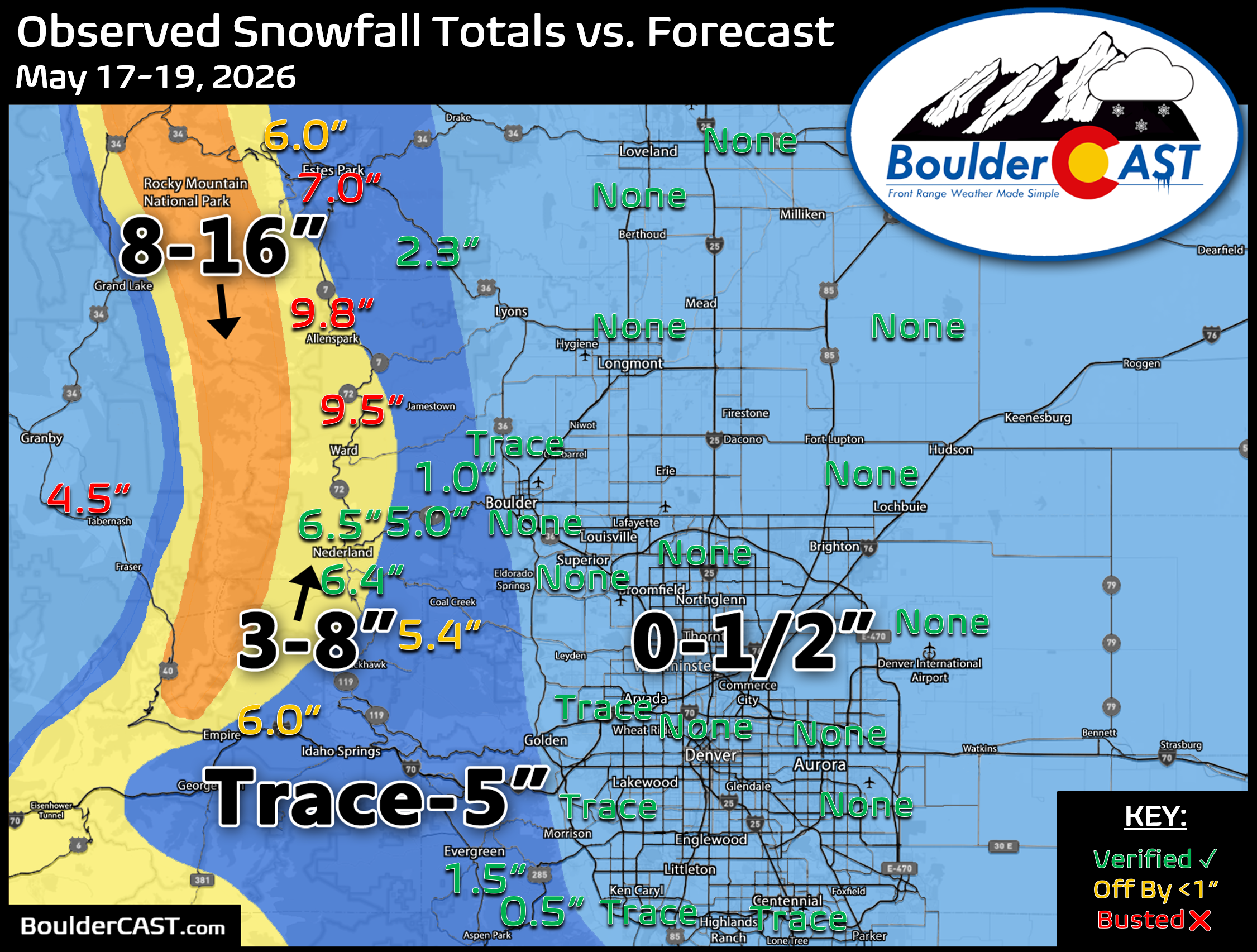
The season’s last gasp came May 17-19. Another soaking storm brought 1 to 2 inches of rain to Boulder and Larimer Counties (1.44″ officially in Boulder) and 0.5 to 1 inch to most of Denver. Snow levels stayed near 6,500 to 7,000 feet, so as forecast, the lower elevations saw nothing more than a few wet flakes mixed in. The lower and middle Foothills picked up 1 to 5 inches and the higher Foothills and Mountains 5 to 10 inches, slightly more than we forecast.
Here’s the 2025-2026 Snowstorm Report Card
Below we verify our forecasts for a whole winter of snowstorms. We issued “official” snowfall forecasts for 16 events over six months, from November 20th to mid-May. Nearly all of these final forecasts were issued at least 12 hours before the first flakes, and some were posted more than a day in advance.
We’ve included a comprehensive review of 30 locations spread across 9 counties (Adams, Arapahoe, Boulder, Broomfield, Denver, Douglas, Jefferson, Larimer and Weld) in the Denver Metro area, including some of the smaller Foothills towns.
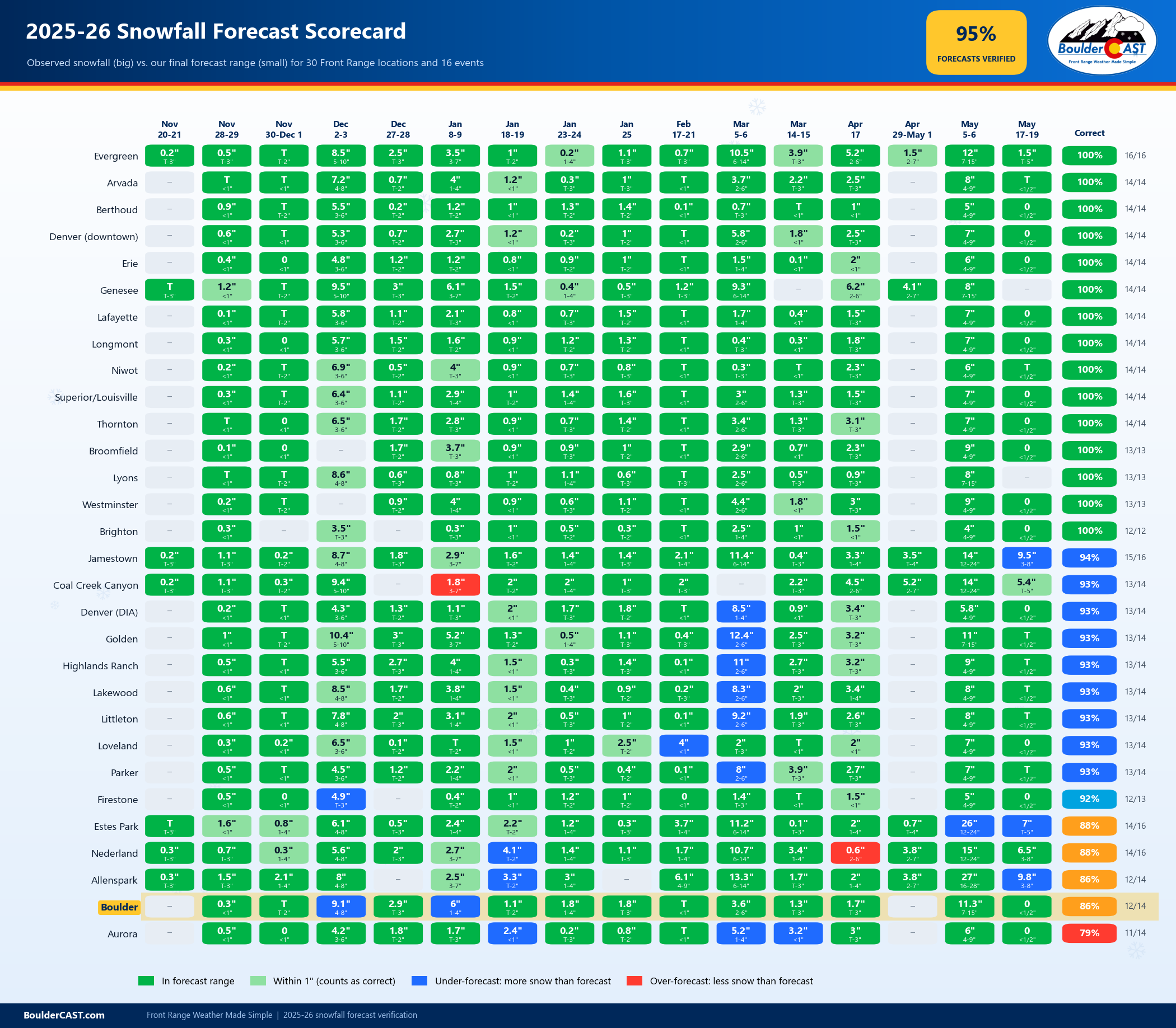
Each location got a “Yay” or “Nay” for each event. To count as correct, the observed snow total had to fall within 1″ of our forecast range. If it fell outside that “buffer inch,” we counted the forecast as incorrect. We only scored forecasts that actually called for snow. Where we forecast rain only or no snow at all (for example, the lower elevations on November 20-21 and April 29-May 1), there was nothing to verify, so those didn’t count. A handful of events also had no snow report near a given location.
Results for each location are below in map form:
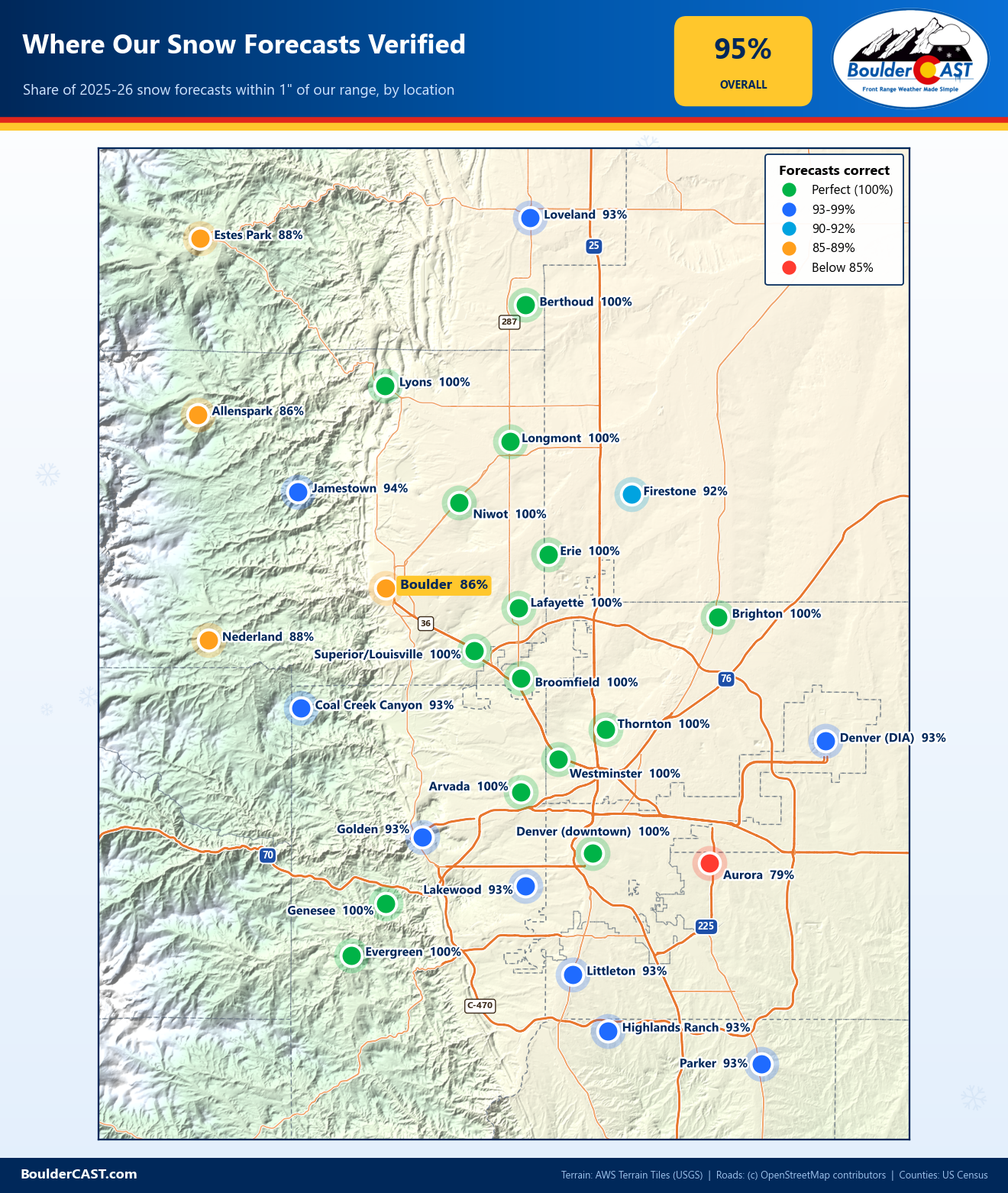
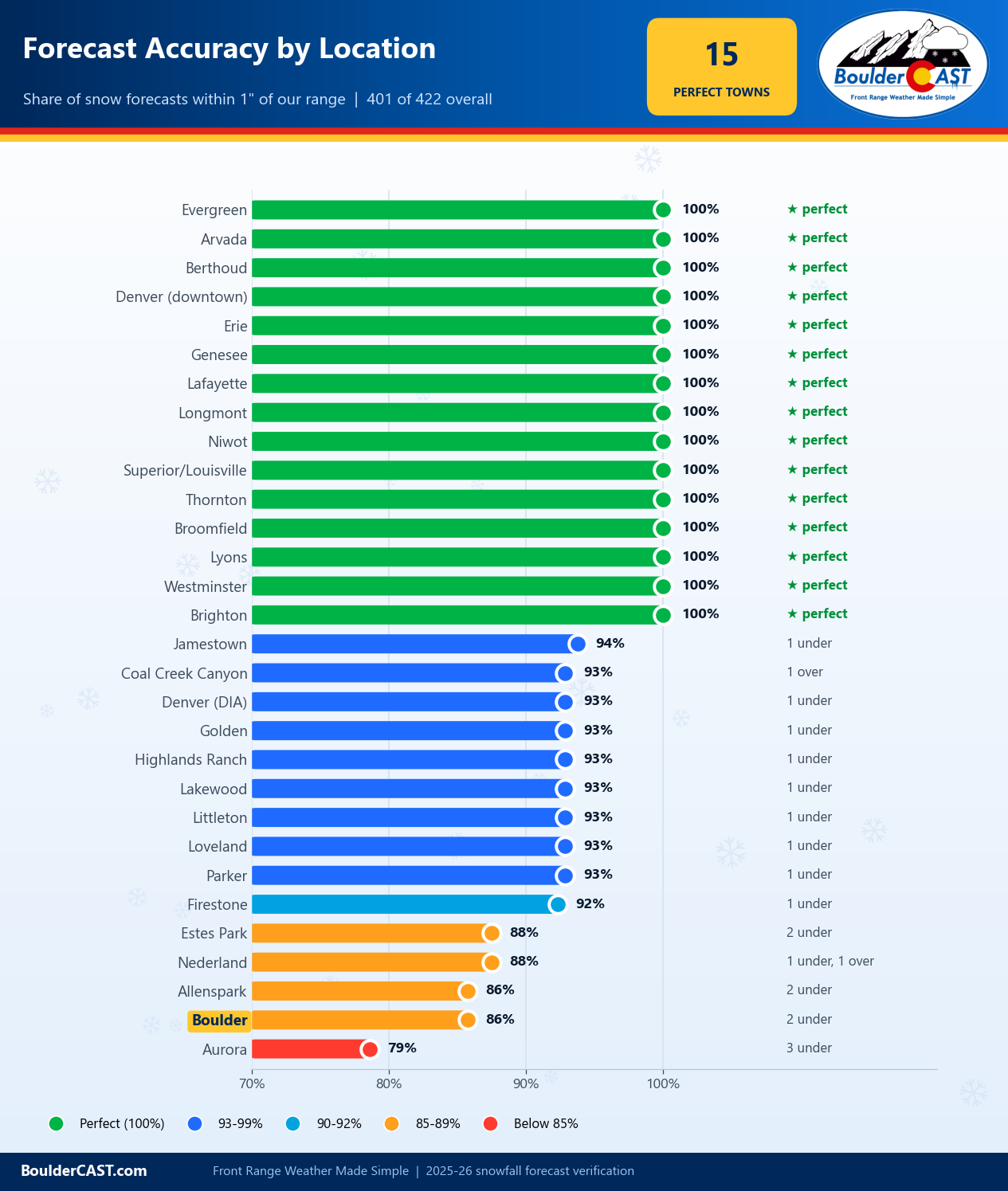
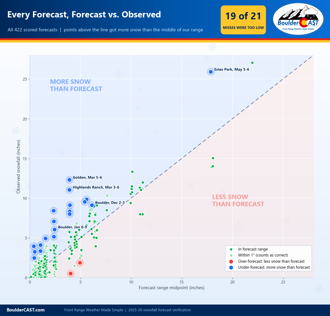
Overall, 401 of the 422 location-forecasts we scored this winter verified, a 95% success rate. Only two of the 21 misses were over-forecasts. We, that is meteorologists in general, often get criticized for predicting too much snow and overhyping snowstorms. The results here are clear. At BoulderCAST, that’s not how we do things.
Want to see the actual numbers? The scorecard below shows every observed snow total next to the forecast range we issued for that location, color-coded by result.
Storm-by-Storm Results for Your Location
Want to see how every storm played out in your own backyard? Pick your town from the dropdown below, and click the graphic for the full-size version. Each one shows our final forecast range, the 1″ buffer and what actually fell for every storm of the 2025-26 season.
Boulder: The Elephant in the Room
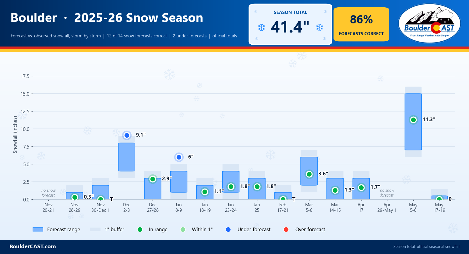
Boulder remains one of the hardest cities on the Front Range to forecast for snow. This season we hit on 12 of the 14 Boulder forecasts that called for snow (86%). Both misses were under-forecasts:
- January 8-9, 2026: Forecast 1-4″, observed 6.0″. Heavy bands from the second, colder Canadian wave set up over Boulder and parked there for a few hours. Most of the Metro area stayed within our ranges, and just one other nearby report (north of Niwot) also busted high.
- December 2-3, 2025: Forecast 4-8″, observed 9.1″. This one was painfully close, missing the buffer inch by just a tenth of an inch. The season’s first real storm ran an inch or so heavier than forecast along much of the Foothills base.
Otherwise we got every “nothing” and “not much” event right, and those made up most of the pitiful season. Correctly forecasting little or no snow matters more than it sounds when the alternative is hyping a storm that never comes. We also nailed Boulder’s biggest storm of the season, with 11.3″ on May 5-6 against our 7-15″ forecast.
Overall Assessment
This was easily one of our most accurate seasons on record. Half of the 30 locations were perfect: Arvada, Berthoud, Brighton, Broomfield, downtown Denver, Erie, Evergreen, Genesee, Lafayette, Longmont, Lyons, Niwot, Superior/Louisville, Thornton and Westminster. Every location scored at least 79%. Granted, a season this short on snow helps. Lots of “trace to an inch” events are easier to verify than a parade of foot-plus storms, and we’ll take the easy wins. But the storms that did produce were mostly handled well too.
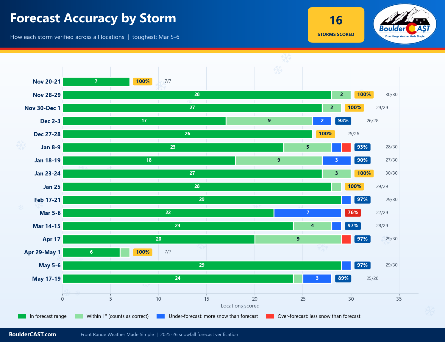
Most of the misses came from just two storms. The March 5-6 boomer accounted for seven of them: Golden, Lakewood, Littleton, Highlands Ranch, Parker, Aurora and DIA, which picked up 8 to 12 inches against forecasts of 1-4″ or 2-6″. It was the season’s clearest example of short-range models trending wetter faster than we were willing to follow. The May 17-19 storm accounted for three more, as the higher Foothills (Estes Park, Allenspark and Jamestown) collected 7 to 10 inches of wet snow when we expected the snow line to hold a bit higher. Aurora was our toughest location at 79%. Convective snow bands overperformed east of Denver three separate times this season, in mid-January and twice in March.
The bigger theme was under-forecasting: 19 of our 21 misses were too low, not too high. The only two over-forecasts were in the Foothills: Coal Creek Canyon on January 8-9 (1.8″ against 3-7″) and Nederland on April 17 (less than an inch against 2-6″). In a winter this dry, it’s tempting to assume every storm will underdeliver, because most of them did. The storms that broke that pattern (January 8-9 and March 5-6) were both cases where short-range guidance had the right idea and our forecast didn’t go far enough. That’s a lesson we’ll carry into next winter.
Thanks for toughing last winter out with us!
Now it’s on to the next one. With a strong El Niño in place, the odds tilt toward a snowier winter for the Front Range and eastern Plains than the one we just survived, though it may be slow to get going. Whatever this season brings, we’ll be forecasting every storm with the same approach, and next spring we’ll be back to grade ourselves all over again. Here’s hoping that recap has a whole lot more snow to talk about. Thanks for reading!
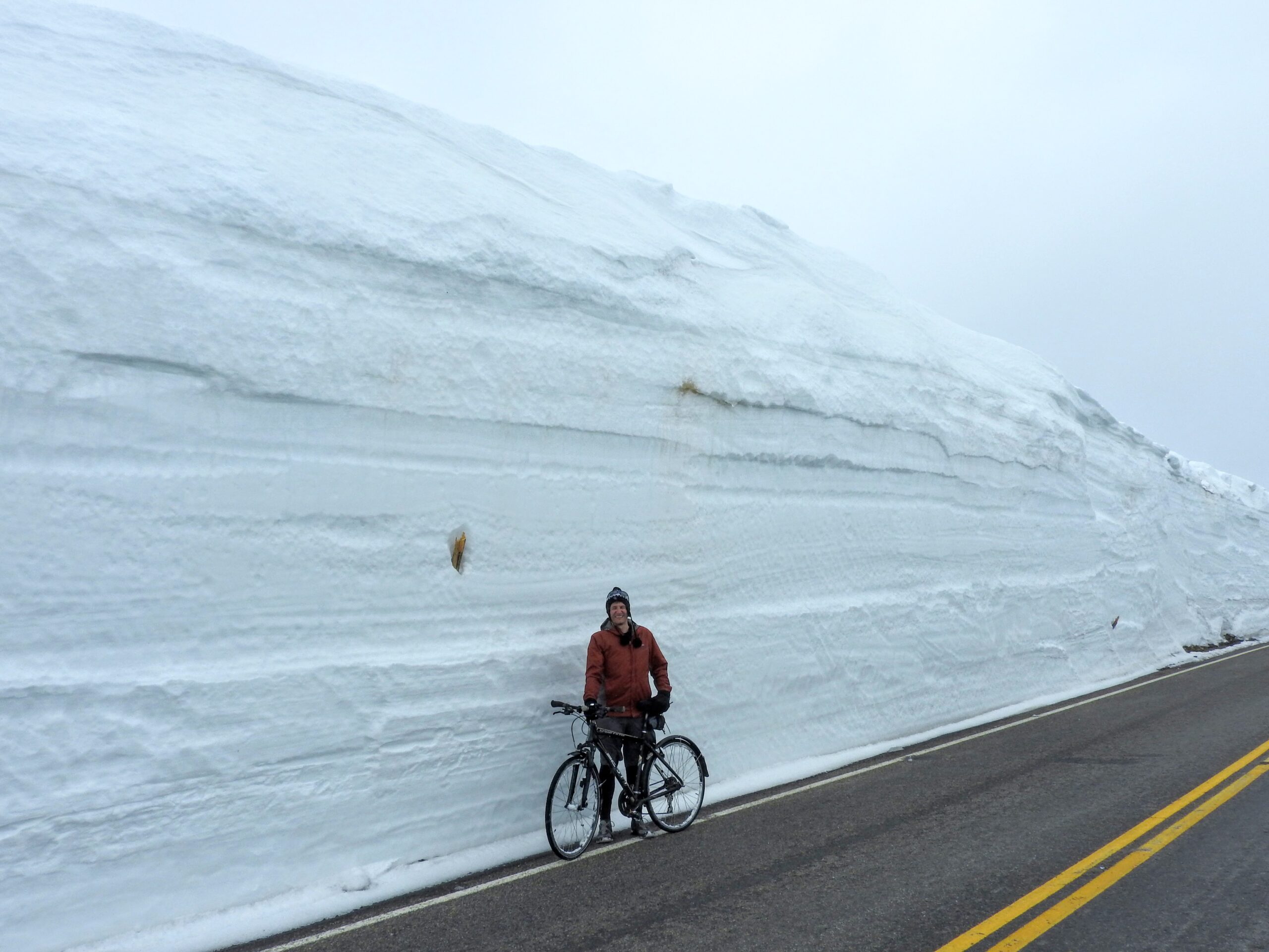
Trail Ridge Road in RMNP. May 2019.
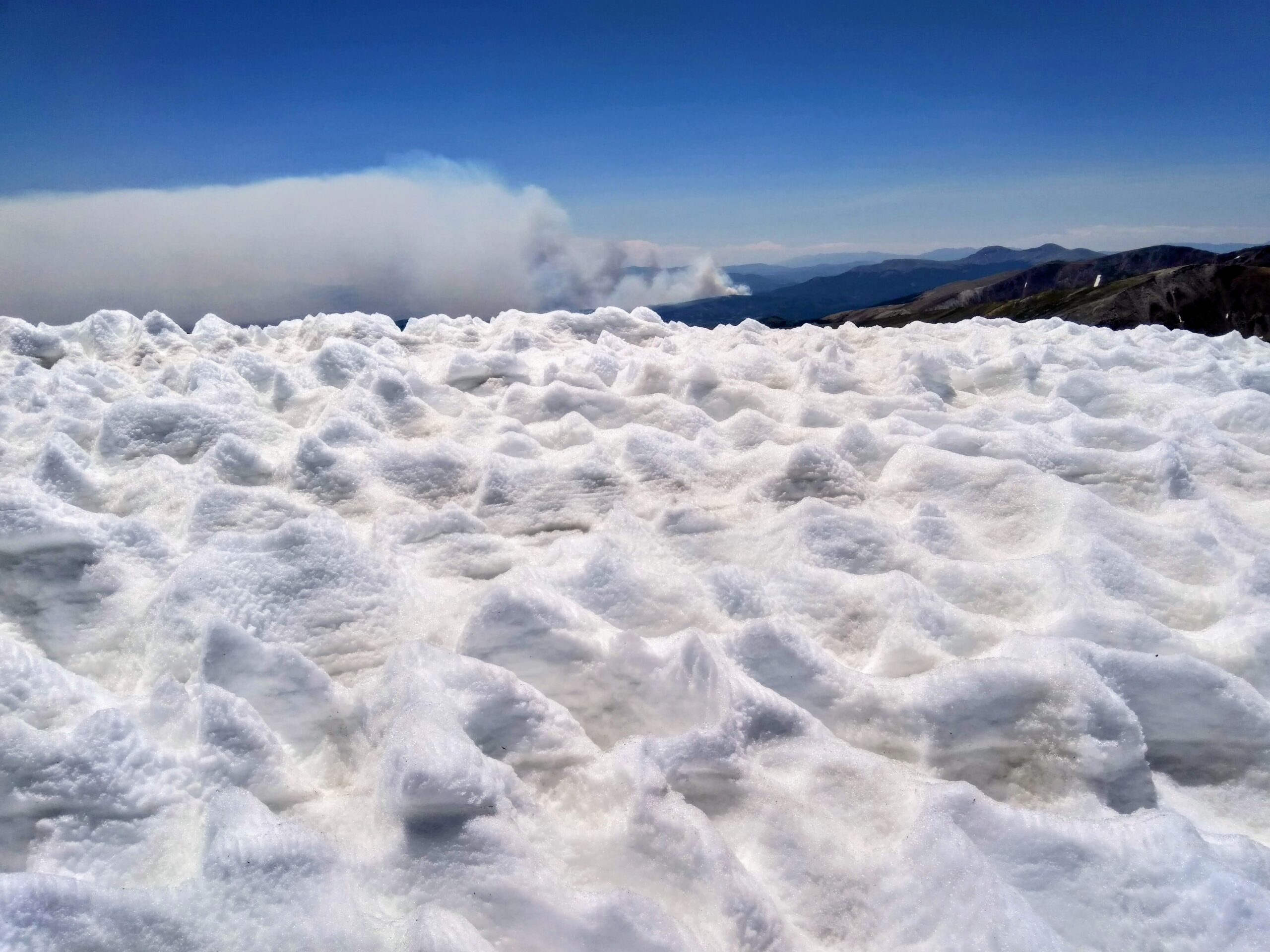
July 2018. Foreground shows alpine snowpack sun cups. Background shows a growing wildfire.
Storm-by-Storm Summaries
May 17-19, 2026
Boulder: None (0 – 1/2″ forecast)
Denver: None (0 – 1/2″ forecast)
Storm Forecast | Recap
May 5-6, 2026
Boulder: 11.3″ (7-15″ forecast)
Denver: 5.8″ (4 – 9″ forecast)
Storm Forecast | Recap *Premium*
April 29-May 1, 2026
Boulder: None (Trace or less forecast)
Denver: None (None forecast)
Storm Forecast
April 17, 2026
Boulder: 1.7″ (Dusting – 3″ forecast)
Denver: 3.4″ (Dusting – 3″ forecast)
Storm Forecast | Recap
March 14-15, 2026
Boulder: 1.3″ (Trace – 3″ forecast)
Denver: 0.9″ (Less than 1″ forecast)
Storm Forecast | Recap

March 5-6, 2026
Boulder: 3.6″ (2 – 6″ forecast)
Denver: 8.5″ (1 – 4″ forecast)
Storm Forecast | Recap

February 17-21, 2026
Boulder: Trace (Less than 1″ forecast)
Denver: Trace (Less than 1″ forecast)
Storm Forecast | Recap
January 25, 2026
Boulder: 1.8″ (Dusting – 3″ forecast)
Denver: 1.8″ (Trace – 2″ forecast)
Storm Forecast | Recap
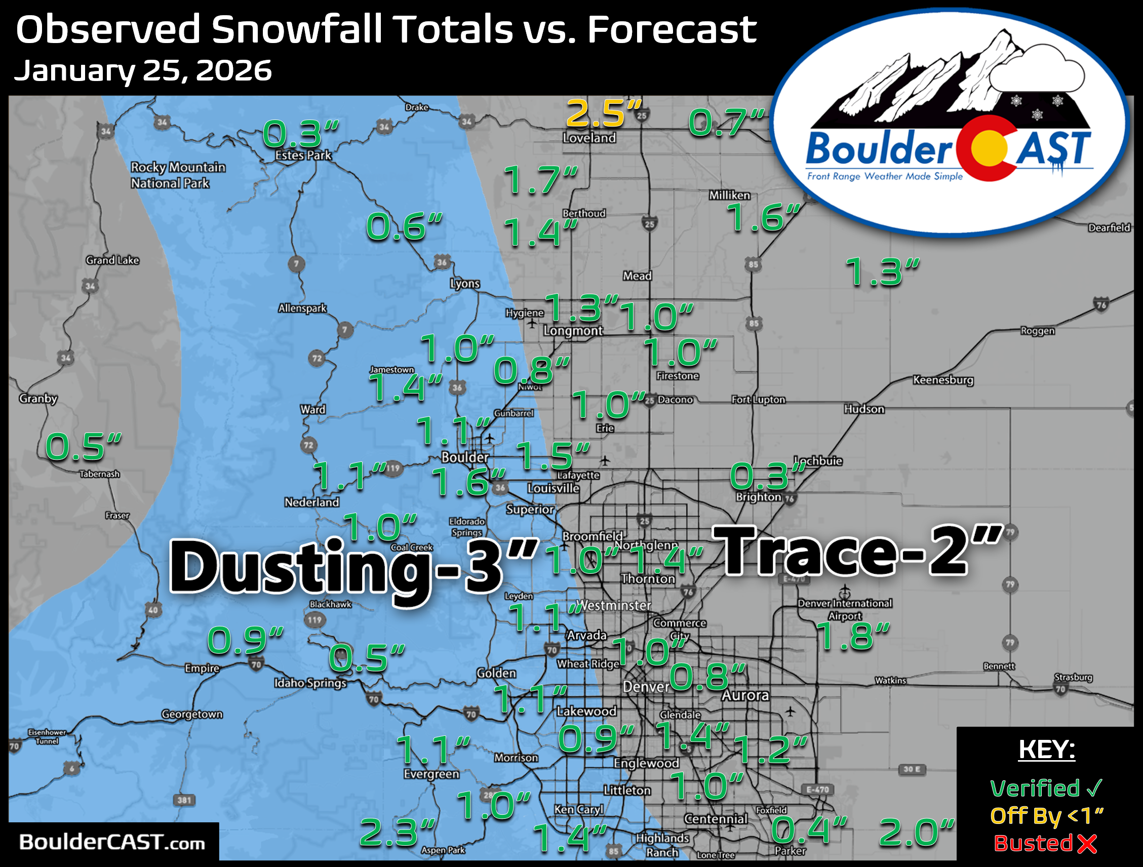
January 23-24, 2026
Boulder: 1.8″ (1 – 4″ forecast)
Denver: 1.7″ (Dusting – 3″ forecast)
Storm Forecast | Recap
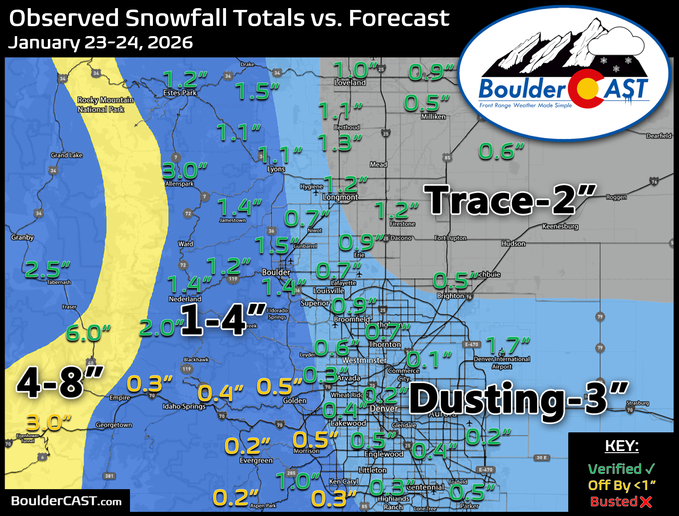
January 18-19, 2026
Boulder: 1.1″ (Trace – 2″ forecast)
Denver: 2.0″ (Less than 1″ forecast)
Storm Forecast | Recap
January 8-9, 2026
Boulder: 6.0″ (1 – 4″ forecast)
Denver: 1.1″ (Trace – 3″ forecast)
Storm Forecast | Recap

December 27-28, 2025
Boulder: 2.9″ (Trace – 3″ forecast)
Denver: 1.3″ (0 – 2″ forecast)
Storm Forecast | Recap
December 2-3, 2025
Boulder: 9.1″ (4 – 8″ forecast)
Denver: 4.3″ (3 – 6″ forecast)
Storm Forecast | Recap
November 30-December 1, 2025
Boulder: Trace (Trace – 2″ forecast)
Denver: Trace (Less than 1″ forecast)
Storm Forecast | Recap
November 28-29, 2025
Boulder: 0.3″ (Less than 1″ forecast)
Denver: 0.2″ (Less than 1″ forecast)
Storm Forecast | Recap
November 20-21, 2025
Boulder: None (None forecast)
Denver: None (None forecast)
Storm Forecast

Spread the word, share our crazy Colorado weather:
Go Premium, get all the perks.
Daily Forecast Updates
Get our daily forecast discussion every morning delivered to your inbox.
All Our Model Data
Access to all our Colorado-centric high-resolution weather model graphics. Seriously — every one!
Ski & Hiking Forecasts
6-day forecasts for all the Colorado ski resorts, plus more than 120 hiking trails, including every 14er.
Smoke Forecasts
Wildfire smoke concentration predictions up to 72 hours into the future.
Exclusive Content
Weekend outlooks every Thursday, bonus storm updates, historical data and much more!
No Advertisements
Enjoy ad-free viewing on the entire site.




Leave a Reply
You must be logged in to post a comment.