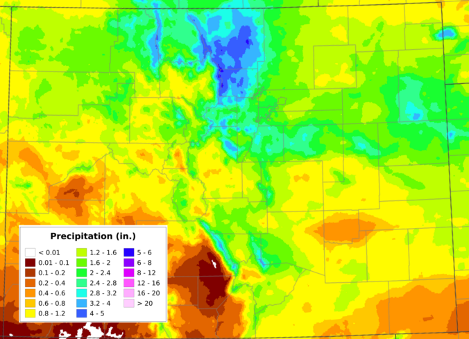
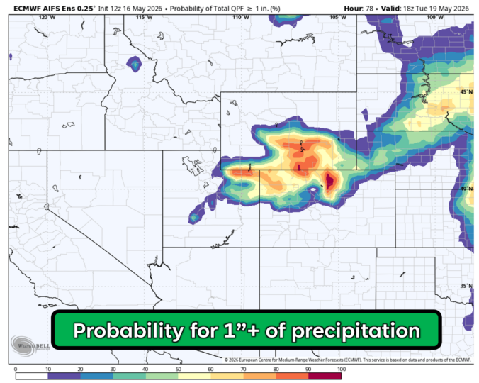
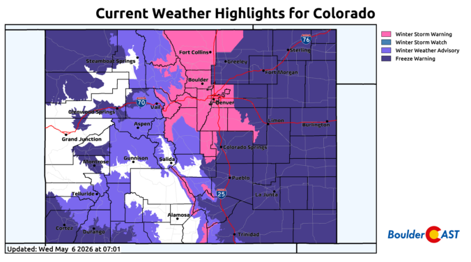
Category: Winter Weather (Page 1 of 113)

These posts contain some discussion of the white stuff, whether it be mountain snow pack or a Front Range snowstorm.

Forecast Update: A super-soaker storm will slam the Front Range this weekend, up to 4 inches of rainfall and 2 feet of snow possible

A developing Four Corners low pressure system will move across southern Colorado this weekend producing a prolonged period of moist upslope flow into the Front Range. While temperatures will (fortunately) be too warm for snowfall across the lower elevations, anywhere from 1 to 4″ of rainfall is expected to dump on our area. Where temperatures are colder, the higher Foothills and Mountains could see over 2 feet of snow from this system as well. Here’s our latest thoughts on the incoming soggy rain (snow) storm!

Continue reading

Winter Weather Update: After a month-long break, another spring snowstorm begins late Friday afternoon

After a month long hiatus, widespread accumulating snowfall will return to the Front Range late Friday as a classic jet-forced banded snowfall event unfolds across the area. While final snowfall totals will undoubtedly vary from location to location, we discuss the latest details of the springtime snowflakes knocking on our door, including when things will commence and expected travel impacts.

Continue reading

This Week in Colorado Weather: April 15, 2024

Warm temperatures, low humidity, and strong gusty winds will start our week with continued fire danger across the Plains. A strong area of low pressure will also bring the threat of rain showers late Monday into Tuesday to the Denver Metro area, with heavy snow piling up in the Mountains. Later in the week, a cold front will slide down ushering in below normal temperatures and upslope flow. A prolonged period of unsettled weather will follow this front, with even some late-season snow possible in the Metro area and heavy snow looking likely in the Foothills. Read on to find out more.

Continue reading

March 2024 Graphical Weather Review: A chilly month headlined by one massive, sloppy snowstorm!

The month of March was fairly dry and chilly most of the time, but we can’t forget the historic El Niño snowstorm which slammed the entire Front Range around the middle of the month. Snow totals of 1 to 2 feet occurred in Boulder and Denver with up to 5 feet fell in the nearby Foothills. Here’s a quick and colorful graphical recap of our weather during March and how it relates to climatology.

Continue reading

Forecast Update: Weekend storm offers little in the way of precipitation, but could produce winds up to 100 MPH around Boulder

An exceptionally strong spring storm is approaching Colorado which will develop into a big ol’ blizzard in the coming days. However, unlike the last few storms which have been direct hits on the Front Range, this one will track further north leading to more wind than precipitation in our area. After a warm and gusty Friday with high fire danger, the incoming storm will bring colder temperatures and a brief chance of rain/snow showers on Saturday. The biggest impacts from this system, though, will come in the form of prolonged damaging downslope winds. We take a look at the large-scale atmospheric setup and discuss the potential snowfall amounts and which unlucky areas have a chance at wind gusts up to 100 MPH this weekend.

Continue reading

« Older posts