After a lively stretch of monsoon storms and even some flooding across the state, the atmosphere is shifting in a way that favors heat, haze, and a temporary shutdown of our storm pipeline for the Front Range. A stout Southwest heat dome is about to take center stage, triple‑digit temperatures are lining up for Boulder and Denver, and wildfire smoke is poised to make an unwelcome return. We break down the ridge, the records, the smoke, and the eventual cooldown.
Author: BoulderCAST Team (Page 1 of 49)
This post had major contributions from at least two members of our team. The more meteorologists the better, right?
A surge of true monsoon moisture is finally breaking through the Front Range’s persistent dry shield. After Tuesday night’s northern‑tier storms offered a preview, the next two days will bring the real deal: widespread convection, highly anomalous moisture, torrential rainfall rates, and the best shot at real rain we’ve had in weeks. If you’ve been waiting for a break from the seemingly never-ending heat of summer and a return of stormy skies, the next few days are poised to deliver.
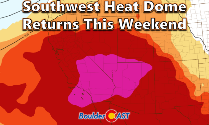
A powerhouse heat dome is about to sprawl across the entire country, and while Colorado’s Front Range won’t sit dead-center in the bullseye, we’re still in for a long, stubborn stretch of serious heat. Daytime temperatures will soar into the middle 90s to low 100s, with warm nights that barely cool off, and skies so clear you might just forget what a cloud looks like.
A subtle shift in the ridge’s position will save Denver and Boulder from the truly unprecedented temperatures that some weather apps and models were flashing earlier this week — but the stage will be set for a scorching Western Slope, lingering fire concerns, and a delayed monsoon that is just now trying to claw its way north. We break down what’s coming, where the heat will hit hardest, and when relief might finally show up.
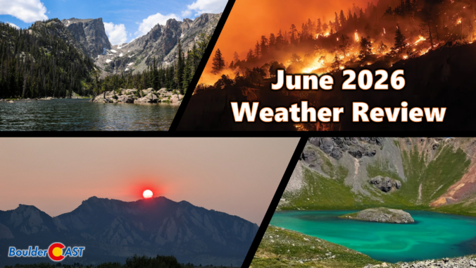
June 2026 closed out as a parched, smoky, and somewhat warm month across the Front Range, with Boulder seeing almost no meaningful moisture aside from a few late‑month storms — some of which dumped large hail across portions of the Denver Metro area. Day after day, smoke‑laden skies from both distant and eventually in‑state wildfires muted visibility and degraded air quality, a stark reminder of how the West’s exceptionally warm, snow‑deficient winter is now echoing across the region in the form of early‑season fire activity and persistent haze.
Here’s a graphical look at how June 2026 unfolded across Boulder, Denver, and the Front Range — and how it compared to climatology.
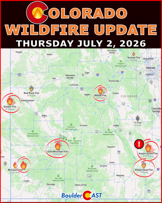
We provide a brief status update on the largest and most impactful wildfires burning across Colorado as of Thursday July 2, 2026 at 10AM.
Colorado has been stuck in a dry, windy southwest‑flow pattern all week that has led to more than 130,000 acres of forest and shrubland burning across the state in nearly a dozen large fires. Now, as we head into the holiday weekend, the pattern finally shows some give: winds ease, temperatures climb, and a slow return of low‑level moisture should allow a few storms to sneak back into the Front Range. It’s not a full reset — meaningful rainfall will still be hard to come by for now — but the atmosphere is nudging Colorado toward a more familiar early‑July rhythm just in time for the Fourth. We break down how this evolving setup will shape the weekend’s weather, fire danger, and your outdoor plans.
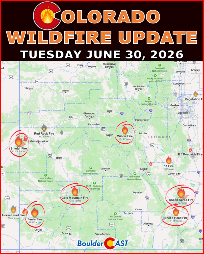
We provide a brief status update on the largest and most impactful wildfires burning across Colorado as of Tuesday June 30, 2026 at 9AM.
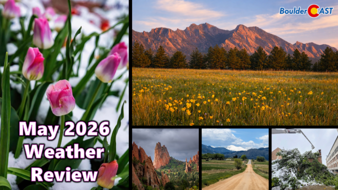
May 2026 delivered a true roller‑coaster pattern along the Front Range. Despite finishing warmer than average, the month was punctuated by two significant chilly precipitation events that funneled a remarkable amount of moisture into Boulder and Larimer Counties. The first arrived as a damaging late‑season snowstorm, wrecking leafed‑out trees across the region, while the second system — fortunately — remained all rain at lower elevations.
Together, these systems provided meaningful drought relief, though the broader hydrological picture across Colorado and the West remains deeply strained. Here’s a graphical look at how May unfolded across Boulder, Denver, and the Front Range — and how it compared to climatology.

Live View of Boulder

Current Conditions

Live Radar

Latest Smoke Forecast

Recent Premium Posts

BoulderCAST Daily – Sun 08/02/26 | The Front Range Braces for a 100° Doubleheader
🔥 Record Heat — A dominant ridge over the Desert Southwest drives temps …
BoulderCAST Daily – Sat 08/01/26 | Hot Temperatures Build This Weekend
🌡️ Dangerous Heat and Air Quality — Boulder and Denver return to triple …
BoulderCAST Daily – Fri 07/31/26 | Marginal Risk of Severe Storms with Smoke and Haze
🌧️ Isolated Storms — This afternoon and evening, with a marginal risk of …
3-Day Forecast

Trending Content

© 2026 Front Range Weather, LLC