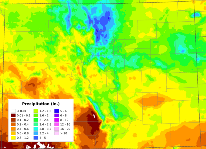
May has finally snapped the atmosphere out of its months‑long bone dry spell, and the Front Range is making up for lost time fast. A destructive early‑May snow event, followed by a second, well‑timed upslope system just ten days later, has pushed Boulder’s May precipitation total beyond everything we managed to scrape together through fall, winter, and early spring combined. We dig into what triggered the pattern reversal, how much moisture different parts of the region have banked, what this burst of wet weather actually means for our entrenched drought, and whether the upcoming Memorial Day weekend warm‑up signals a slide back toward a more aggressive drying trend.
Author: BoulderCAST Team (Page 2 of 49)
This post had major contributions from at least two members of our team. The more meteorologists the better, right?
After a devastating spring snowstorm barely more than a week ago, a slow‑moving May storm parked itself over the northern Front Range, wringing out 1–2 inches of moisture and dropping a fresh blanket of wet snow in the Foothills — all without giving the lower elevations any freezing temperatures. For mid‑May, that’s about as friendly as a storm of this size gets. And with the larger‑scale trough refusing to budge, we’re not done yet: this week will feature more daily shower chances through Friday before drier, warmer weather returns just in time for the holiday weekend. Read on for all the details.
April 2026 wrapped up as another water‑starved month along the Front Range, trading March’s record heat for a parade of fast‑moving systems that looked promising on paper but rarely delivered meaningful moisture. Temperatures still ran warmer than average overall, punctuated by a few sharp cold fronts that briefly returned a wintry feel before the pattern snapped back to mild, windy, and dry. Fire danger stayed elevated on many days, and despite several rounds of light precipitation, Colorado’s snowpack remained historically low heading into May. Let’s take a graphical look at how April unfolded across Boulder, Denver, and the Front Range — and how it stacked up against climatology.
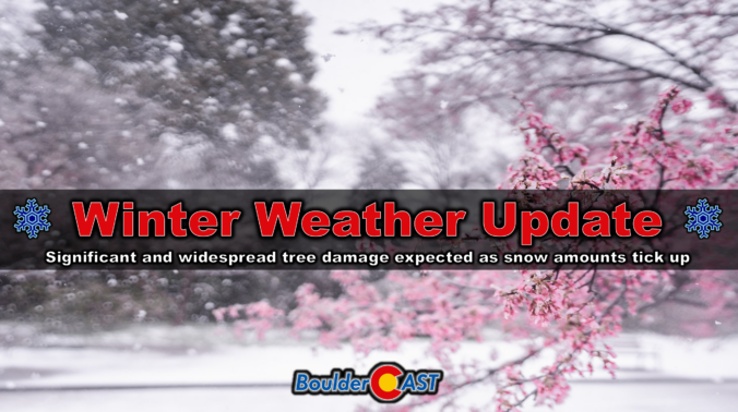
The spring storm rolling across the Front Range has already pulled off quite a transformation, shifting from rumbles of thunder to flakes of heavy, wet snow in just 12 hours. What comes next is shaping up to be even more impressive. Two separate storm systems are preparing to merge over Colorado and the result will be a long stretch of heavy wet snowfall that will have significant impacts for our fully leafed-out trees and power lines. We break down why snowfall amounts have ticked up a tad since yesterday, when and where power outages are most likely to occur, and the broader impacts this wet storm will have across Boulder, Denver and the Front Range.
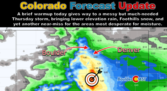
This brief lull in the action Wednesday morning won’t last long as the pattern is set to turn unsettled again in a hurry. A pair of poorly aligned disturbances is gearing up to bring the Front Range a long‑overdue dose of moisture — along with snow in the higher terrain. While the bullseye of heaviest precipitation is frustratingly expected to be south of our area again, a slew of marginal ingredients are coming together for what should be our most meaningful storm in months. We break down what to expect as we head into a soggy, colder, and in some cases, snowier end to the week.
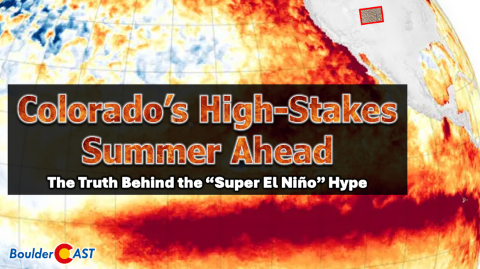
Colorado headlines have been buzzing about a looming “Super El Niño,” but the story behind the hype is far more layered than the headlines let on. Before leaning into the dramatic graphics and sweeping claims, it’s worth unpacking where this narrative actually came from and why one overzealous model run has taken on a life of its own. More importantly, we must consider what this all really means for our state as we limp into summer with record‑low snowpack, deepening drought, and a fire season that has already been sharpening its teeth. The truth is far more nuanced than the current online discourse suggests.
Friday delivered one of those classic Colorado curveballs. The storm showed up fashionably late, then hit harder than expected once it finally got going. It left behind a fast‑melting blanket of spring snow and cleared out almost as quickly as it arrived. In today’s update, we break down the wild midday burst of snow, take a look at how the forecast held up, and highlight why the real headline may have been what happened — or didn’t happen — after the flakes stopped.
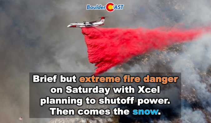
Colorado just wrapped up one of its wildest weather weeks of the season: persistent fire danger, surprise snow, historic damaging winds in Fort Collins, and a sudden arrival of dense wildfire smoke from Nebraska. Even worse, the atmosphere isn’t done with us yet. As we head into the weekend, a fast‑evolving setup is lining up another round of high‑impact conditions for the Front Range, from extreme fire danger to an abrupt overnight flip to snowflakes. And once we get through that, next week brings a pattern shift so extreme it’s poised to rewrite March climatology and decimate the already anemic snowpack across the entire West. Let’s get into it.

Live View of Boulder

Current Conditions

Live Radar

Latest Smoke Forecast

Recent Premium Posts

BoulderCAST Daily – Sun 08/02/26 | The Front Range Braces for a 100° Doubleheader
🔥 Record Heat — A dominant ridge over the Desert Southwest drives temps …
BoulderCAST Daily – Sat 08/01/26 | Hot Temperatures Build This Weekend
🌡️ Dangerous Heat and Air Quality — Boulder and Denver return to triple …
BoulderCAST Daily – Fri 07/31/26 | Marginal Risk of Severe Storms with Smoke and Haze
🌧️ Isolated Storms — This afternoon and evening, with a marginal risk of …
3-Day Forecast

Trending Content

© 2026 Front Range Weather, LLC