Winter may be on the calendar, but it certainly hasn’t been in the air this year. As the West stumbles through one of its warmest, most lopsided cold seasons on record, the signs of a deeper shift are becoming impossible to ignore. From record‑breaking heat along the Front Range to a snowpack crisis unfolding across the entire West, this “winter” has rewritten the rules — and the ripple effects are only beginning to surface. We break down what happened this year, why it matters, and what this complete failure of a winter means for the months ahead.
What You Need to Know
- A Winter That Never Arrived: The western U.S. experienced a near‑total failure of winter this year, driven by a persistent dipole pattern and amplified by La Niña. Many western states recorded their warmest winter on record.
- Front Range Heat Records Shattered: Boulder saw unprecedented warmth: record numbers of 60°, 65°, and near‑record 70° days, the warmest Christmas Eve/Day ever, the latest first freeze in decades, and the warmest November temperature on record.
- Snowfall Collapse and Delayed First Snow: Boulder’s first snowfall arrived on November 29 — the latest on record — and seasonal totals remain at just 46% of normal, among the three worst winters-to-date ever recorded.
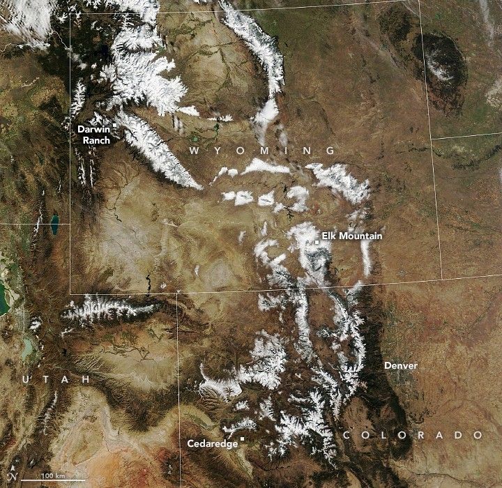
- West‑Wide Snowpack Crisis: Snowpack across the West is historically low not entirely because of missing storms, but because many storms fell as rain at elevations that normally accumulate snow. Colorado’s statewide snowpack sits at only 61% of normal.
- A Tough Rest of 2026 Ahead: Without a major spring pattern shift — which models do not currently support — the deficits from this failed winter will echo through the rest of 2026 and beyond.
- Water Supply at Risk: With snowpack acting as the region’s natural reservoir, the lack of winter accumulation threatens water availability for cities, agriculture, and the entire West heading into summer.
- A Potentially Historic Fire Season Ahead: Warmth and minimal snowpack have primed the region for an early, intense, and long‑lasting fire season, with widespread smoke impacts expected both within Colorado and across the West.

Go Premium, get all the perks.
Daily Forecast Updates
Get our daily forecast discussion every morning delivered to your inbox.
All Our Model Data
Access to all our Colorado-centric high-resolution weather model graphics. Seriously — every one!
Ski & Hiking Forecasts
6-day forecasts for all the Colorado ski resorts, plus more than 120 hiking trails, including every 14er.
Smoke Forecasts
Wildfire smoke concentration predictions up to 72 hours into the future.
Exclusive Content
Weekend outlooks every Thursday, bonus storm updates, historical data and much more!
No Advertisements
Enjoy ad-free viewing on the entire site.
The Year Without Winter in the West
This winter — and the autumn that fed into it — will go down as one of the most anomalous cold‑season patterns ever observed across the western United States. What we’ve lived through isn’t just “warm.” It’s a structural failure of winter itself, driven by a relentless atmospheric setup that refused to budge for months. A stubborn North American dipole pattern locked into place: a deep, frigid trough dominating the eastern U.S. while a warm, bloated ridge camped over the West or just offshore. La Niña helped tilt the scales, but the dipole did the heavy lifting. The result was astonishing, historic, and frankly unsettling. Entire western states logged their warmest winter on record. Meanwhile, the East endured weeks‑long cold snaps not seen in decades, with snow and ice reaching the Gulf Coast and Deep South. Coastal North Carolina has seen more snow than Denver. Parts of Florida have out‑snowed Salt Lake City. That’s how upside‑down this season has been.
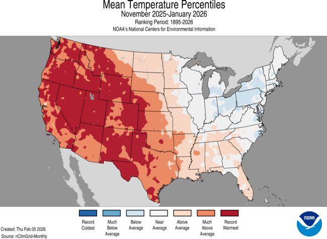
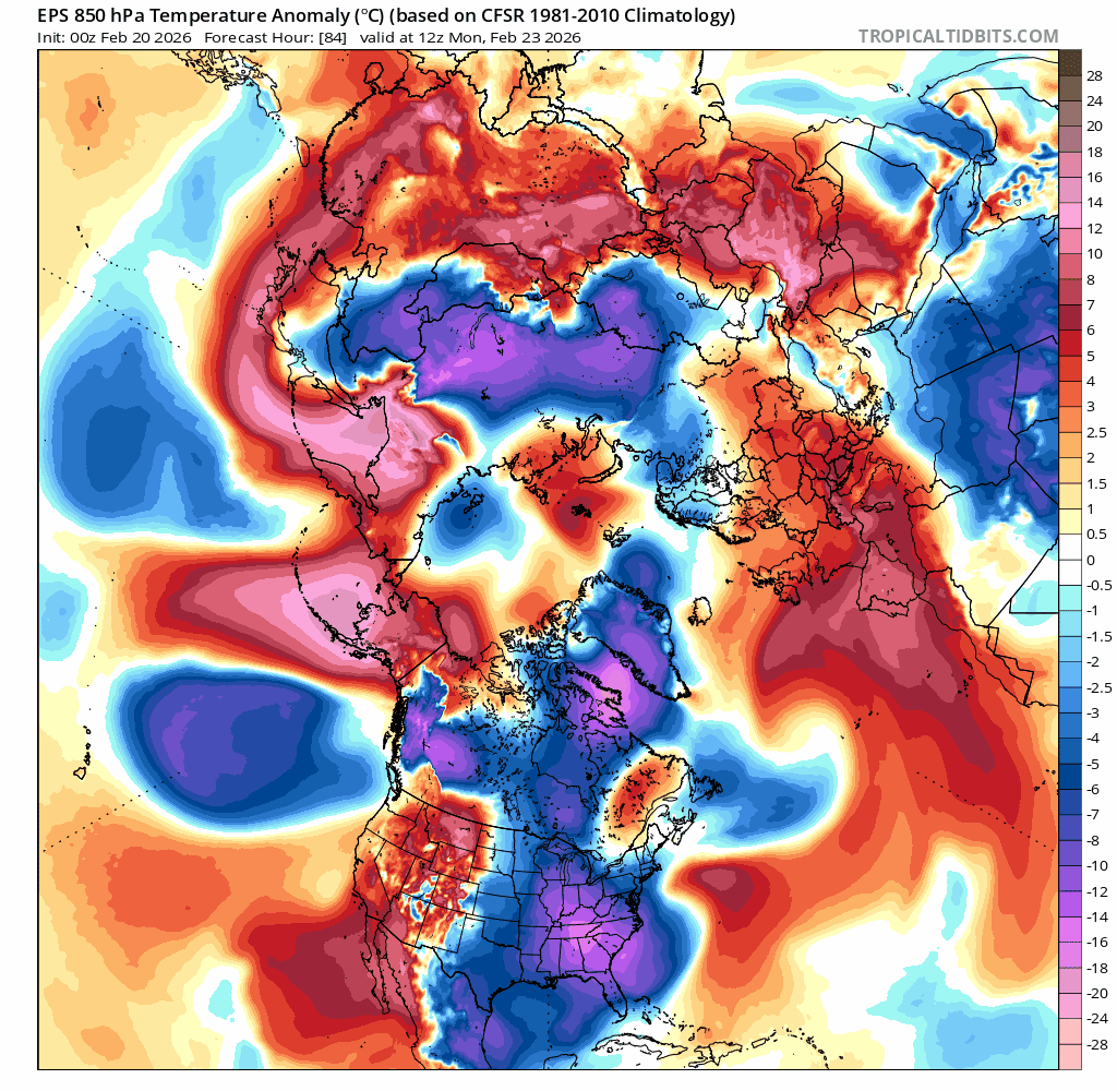
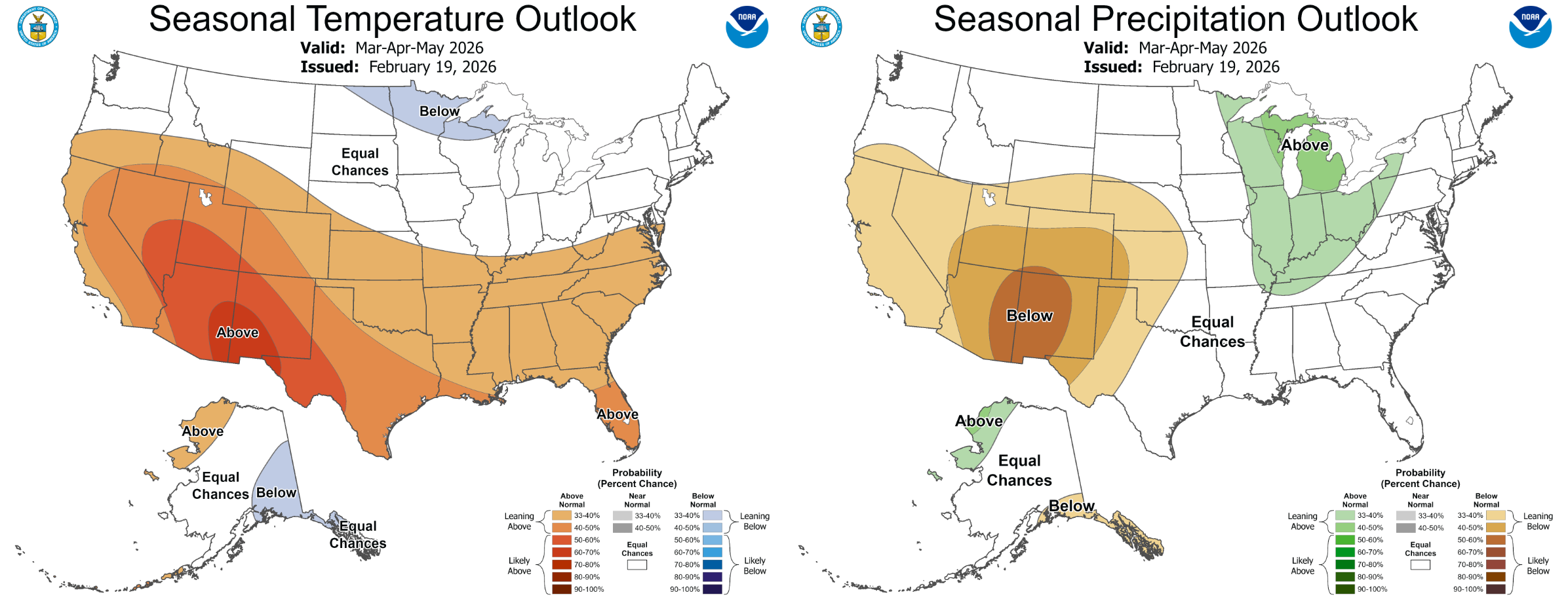
Temperatures have run well above normal in the Front Range Metro area all winter long, with frequent stretches in the 50s, 60s, even 70s. For much of the state, this has been the warmest late-fall and winter in recorded history (everywhere shaded dark red below).
![]()
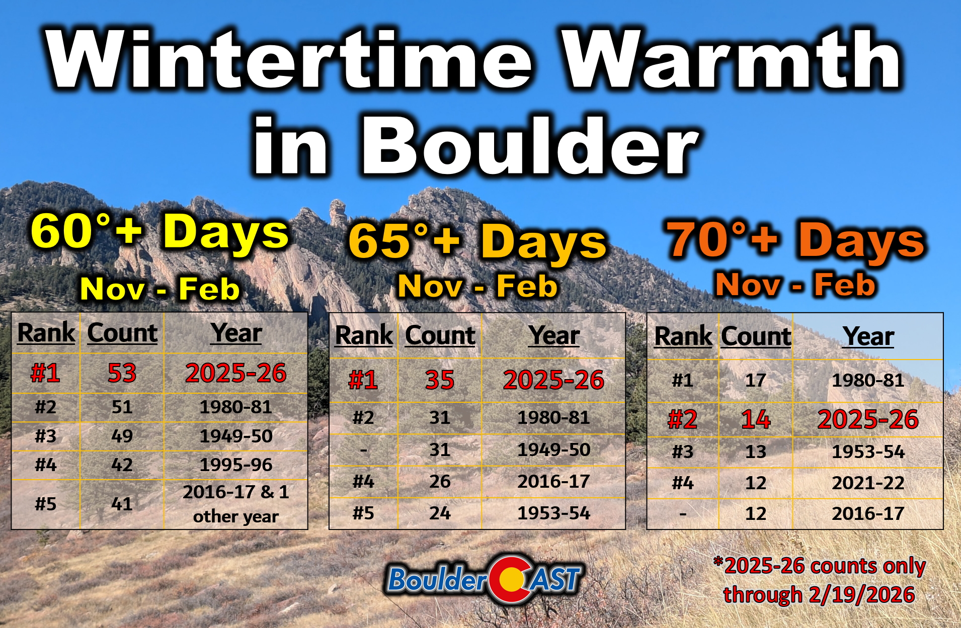
With a week still to go in February, Boulder has already set records for the number of cold-season 60° days (53) and 65° days (35), with a second place finish likely for the count of 70° days (14). These numbers will increase further as another warm pattern is taking shape next week before the calendar rolls into March, with 60s and 70s back in our late-winter forecast.
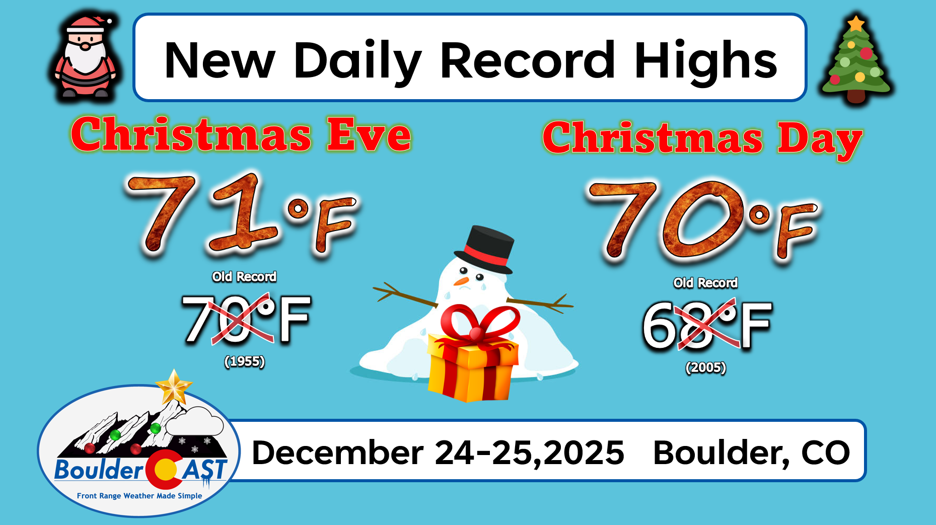
Two of this winter’s 70-degree days landed as Boulder’s all-time warmest Christmas Eve and Christmas Day, back-to-back.
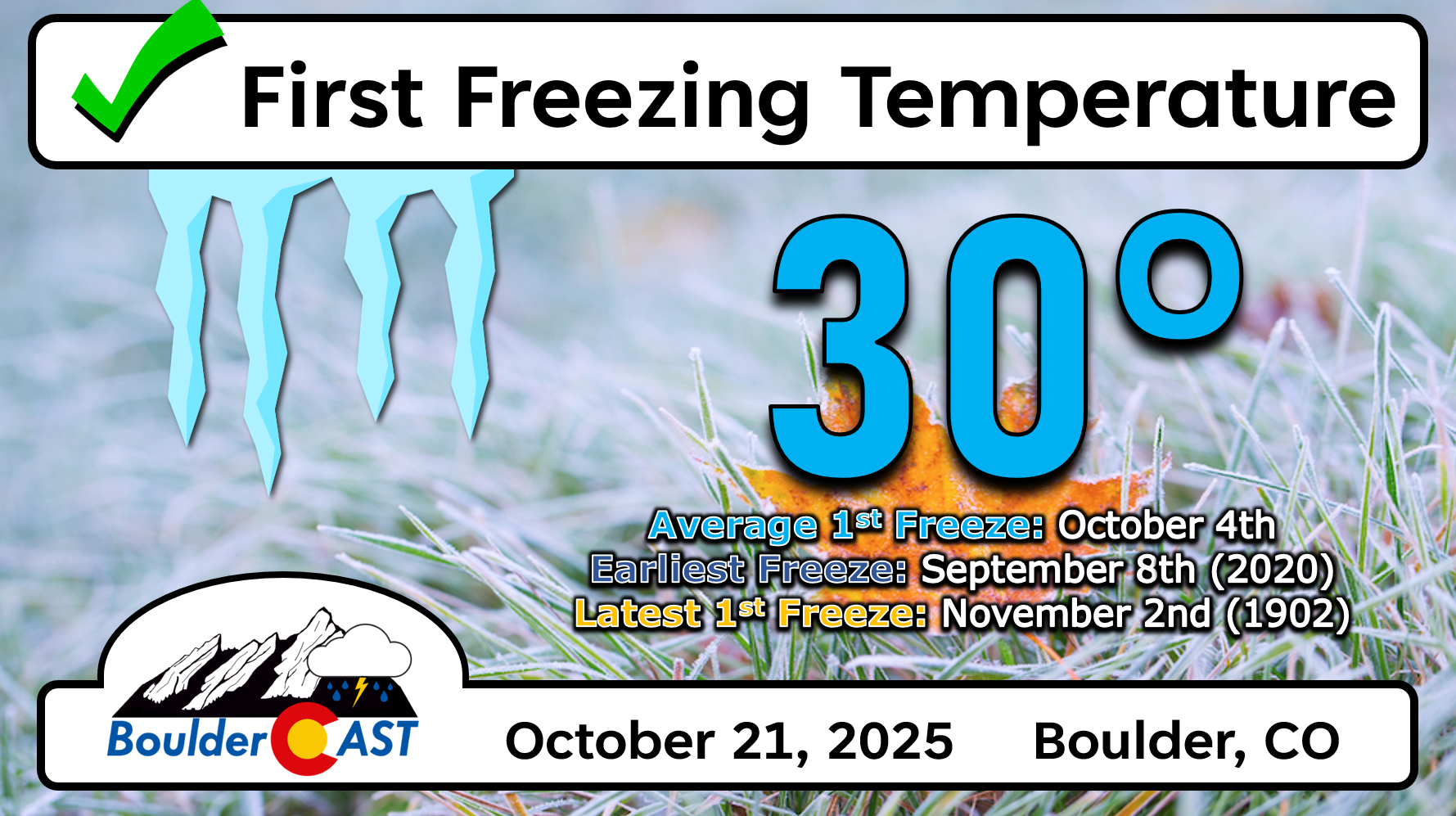
Our first nighttime freeze came three weeks later than schedule on October 21st allowing for an extended growing season in eastern Colorado.
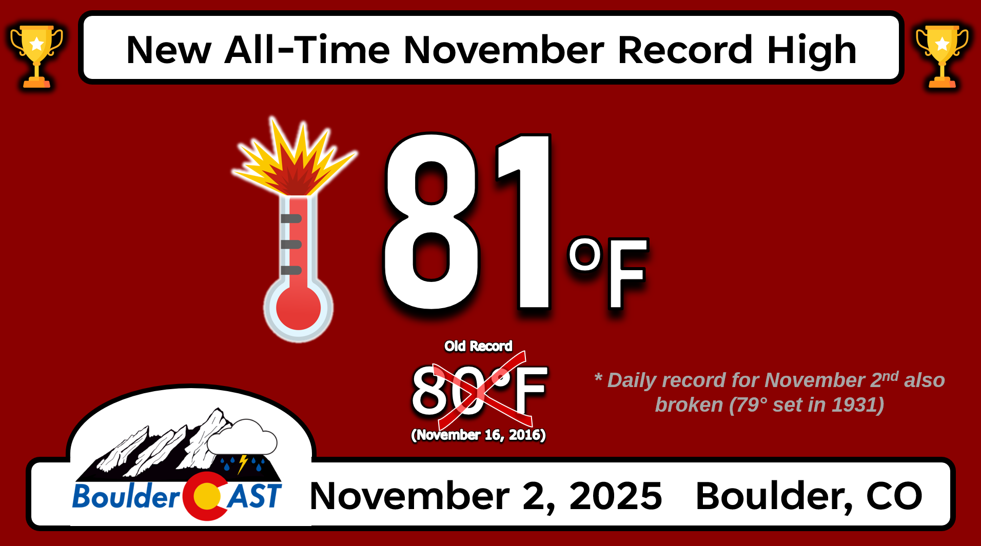
We also set a new all-time monthly record high for November, reaching a summer-like 81° on November 2nd.
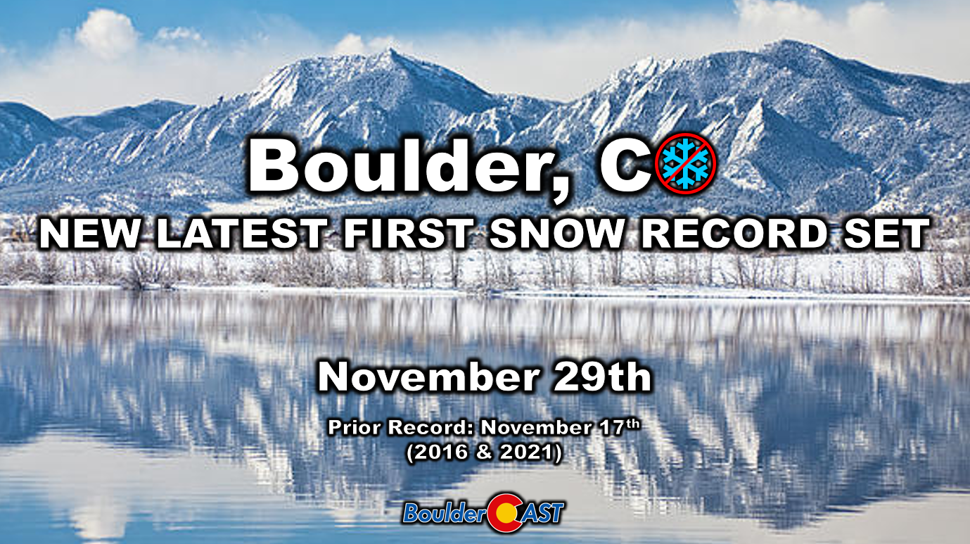
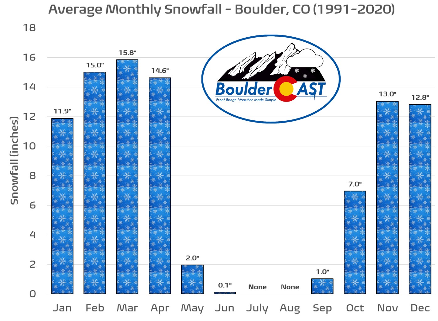
And who can forget the obliteration of our latest first snowfall record?! The first flakes of the season didn’t fly in Boulder until November 29th, twelve days later than the prior record and about six weeks later than normal. This completely wrecked our 11th Annual First Snowfall Contest, with 99% of entries guessing dates too early compared to what unfolded.
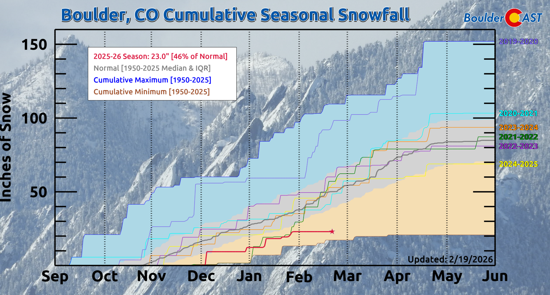
We haven’t caught up much in the snow department either. Boulder is currently sitting at 23.0″ of snow this season which is 46% of normal and the third worst on record season-to-date, behind only the pitiful 1981-82 and 1976-77 winters.
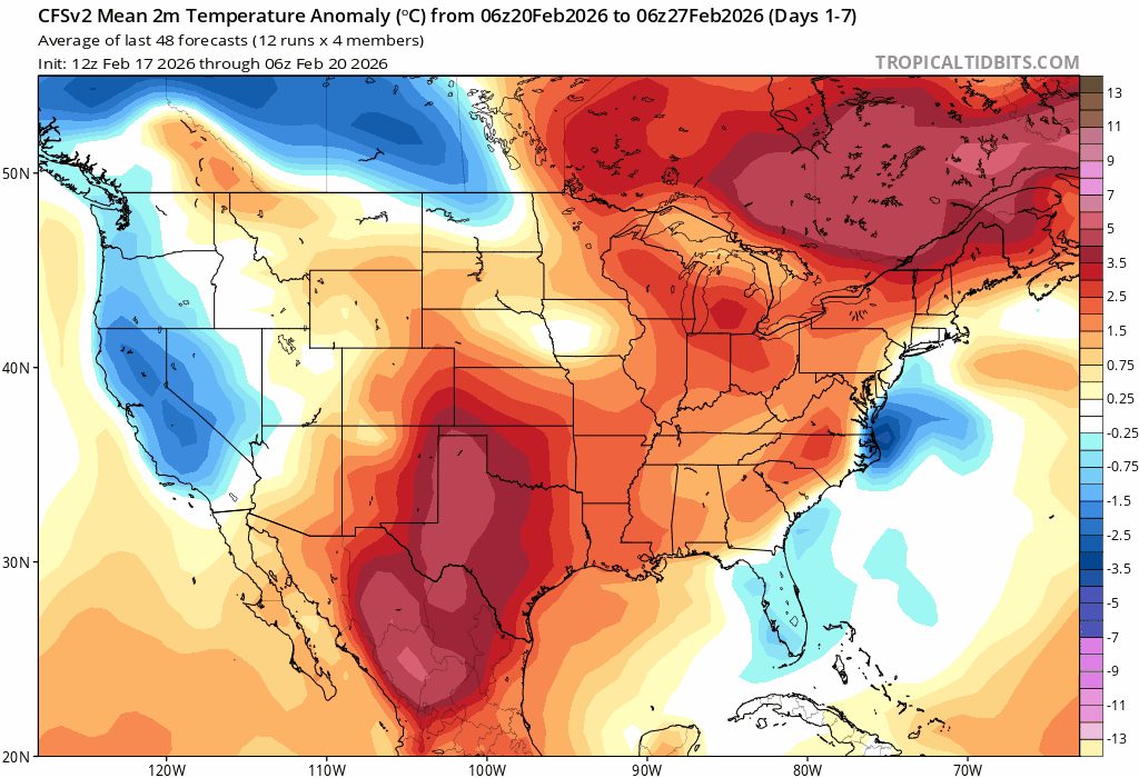
Seasonally appropriate air, let alone true Arctic air, has barely brushed Colorado this winter. Only one meaningful cold snap arrived — in late January — which brought our coldest temperatures of the winter, with subzero nights and highs stuck in the teens for a couple days. That brief stretch has largely been the extend of “winter” weather in the Front Range this year.
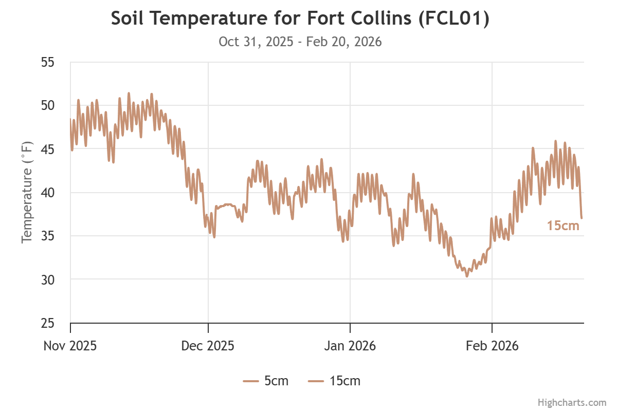
![]()
Even the soil noticed the missing winter. Subsurface temperatures at 6-inch depth in Fort Collins dipped below freezing only once — during that brief late‑January cold snap. Most residential irrigation systems, whose pipes sit 8 to 12 inches below ground, didn’t even need to be winterized this year. That’s how absent true cold has been.
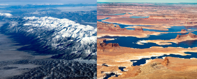
Western Snowpack Crisis: Not a precipitation problem
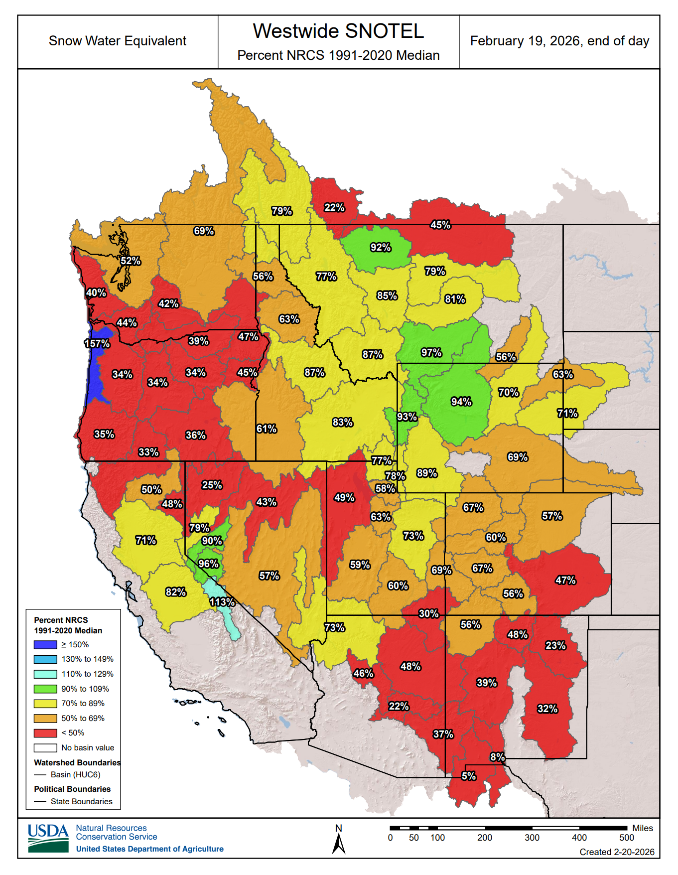
The West’s snowpack is in historically poor shape, and the reason is simple: it was too warm to snow. All but a couple river basins in the western United States are enduring significantly below normal snowpack right now.
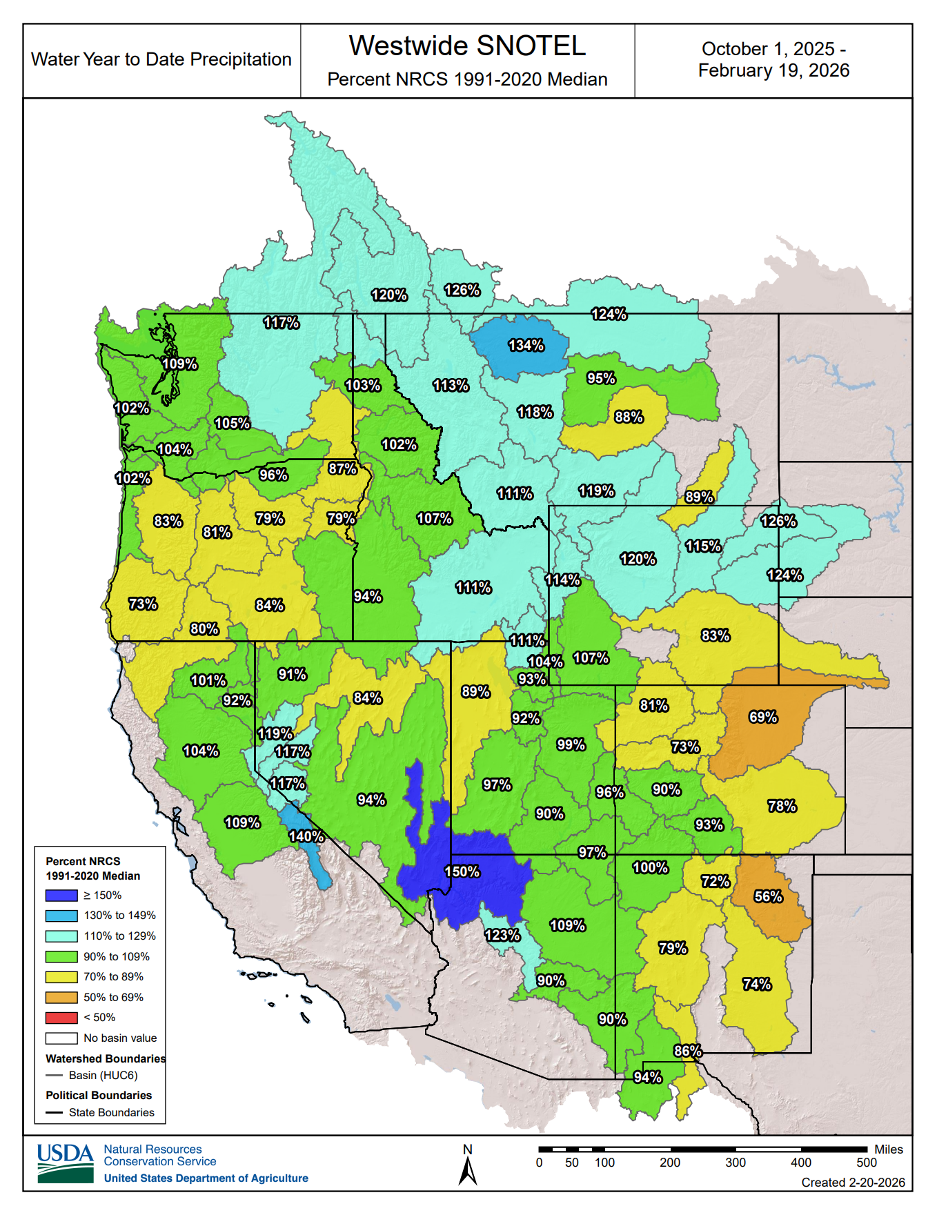
However, the dearth of snowpack isn’t simply due to a lack of precipitation, though that is a factor in some parts. Many areas, including portions of Colorado, have actually received near and even above‑normal moisture this winter.
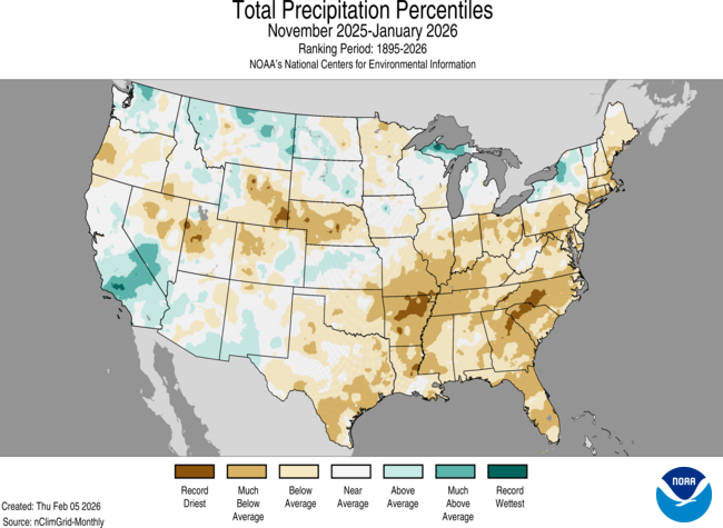
The West-wide precipitation accumulation map by basin tells a much different story, with many picking up respectable moisture since October 1st. Yes, Denver’s South Platte Basin is one of the driest, which we’ve certainly felt, but elsewhere precipitation has been much closer to normal, or even above normal as seen from Wyoming into Montana and western Canada.
The problem has mostly been the warmth: storms that should have delivered snow instead fell as rain at elevations where snowpack typically builds all winter long. This is something we experienced first-hand back in mid-October when hiking at 12,000 feet—it was warm and raining that day! Furthermore, whatever snow did accumulate at mid‑elevations melted repeatedly. Nederland, ski‑town bases, and Foothills communities have struggled to hold snow for more than a few days at a time.
Colorado’s statewide snowpack sits at just 61% of normal as of February 20th, even after a welcome boost from several rounds of Mountain snow this past week. We remain near historic lows despite some recent improvement, with this water year now basically tied with 2002 for the lowest snowpack since record-keeping began in 1987.
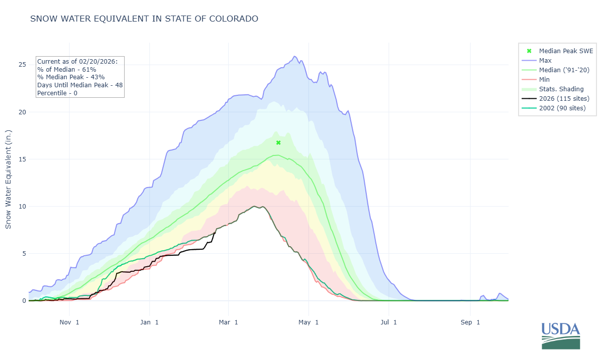
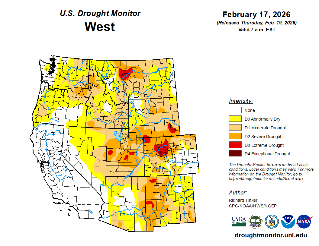
Current drought conditions across the West remain bleak, with large portions of Colorado experiencing everything from moderate to extreme and even exceptional drought, affecting more than half the state as of mid‑February 2026.
Was this record warm and dry winter expected? Sort of.
We went into this winter knowing La Niña would be in play — a pattern that typically keeps an active storm track aimed at the northern Rockies, including northern Colorado. In this setup, the jet stream tends to wobble, sometimes delivering mild, windy stretches along the Front Range with healthy Mountain snow, and other times allowing semi‑regular intrusions of Arctic air that bring light snow or even bouts of freezing drizzle.
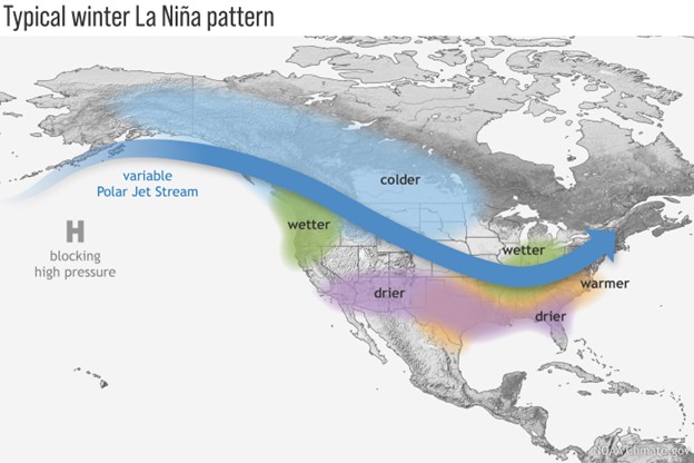
For Boulder specifically, La Niña usually tilts the odds toward below‑normal precipitation and snowfall year-round, with few exceptions.
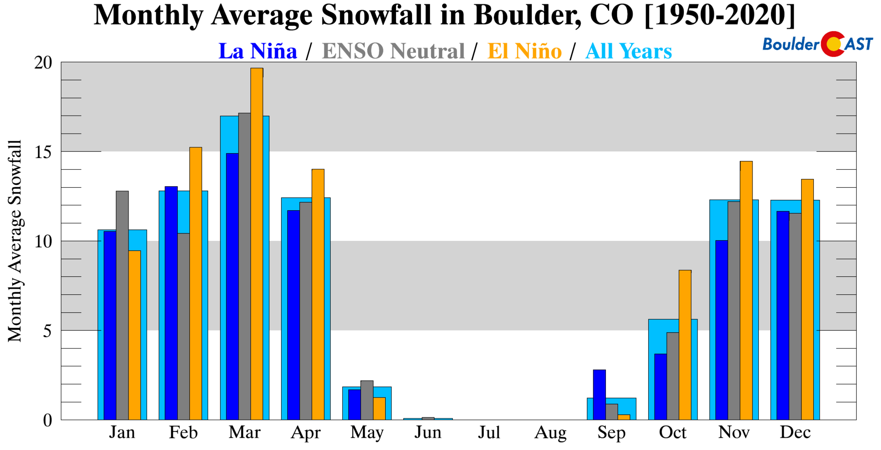
Colorado’s northern Mountains often fare better during La Niña, benefiting from frequent Pacific moisture plumes riding in from the northwest. Meanwhile, Colorado’s southern mountains tend to struggle because the storm track sits too far north and the prevailing wind direction isn’t ideal for strong upslope there.
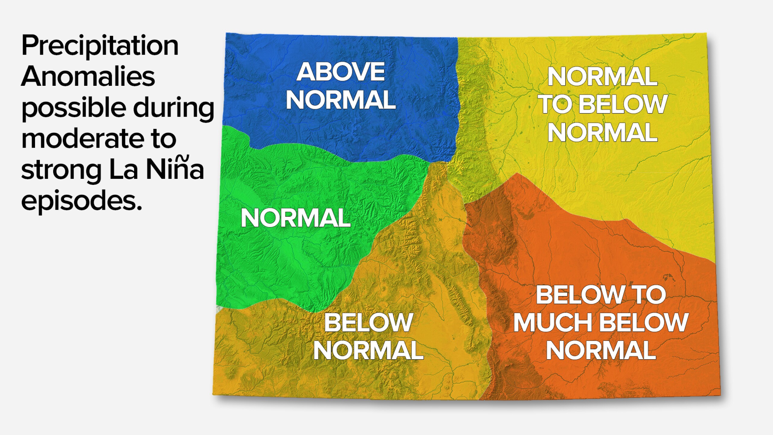
Source: KOAA
But La Niña alone doesn’t dictate our winter. It’s just one ingredient in a much larger atmospheric cocktail. In fact, three of the last five winters (2020–21, 2021–22, 2022–23) were also La Niña years, and all produced near‑normal snowfall in the Boulder area — with two of them finishing above normal. None were particularly dry overall, aside from the exceptionally warm and parched autumn of 2021 leading up to the Marshall Fire. After that event, however, the remainder of the 2021–22 winter turned sharply colder and snowier, ultimately ending above average in terms of snow and precipitation.
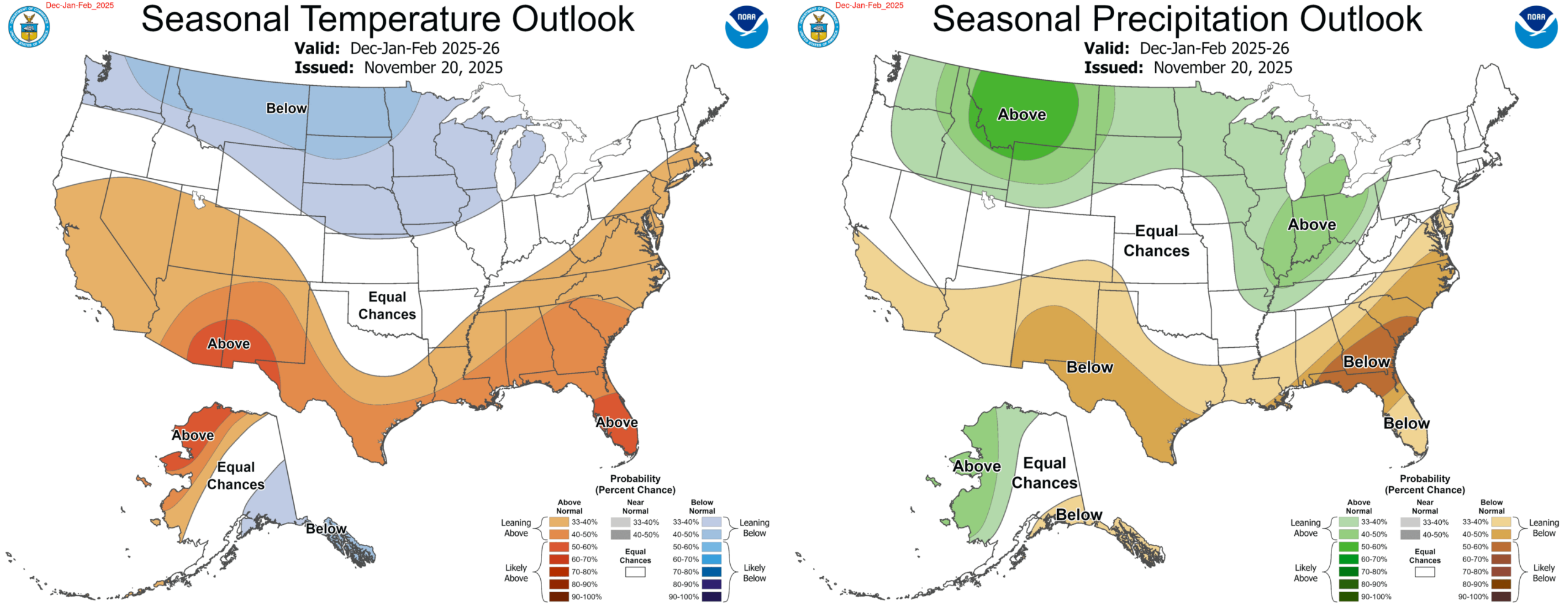
Seasonal outlooks heading into this winter painted a familiar picture: warmer and drier conditions favored across southern Colorado, with colder and wetter conditions across the northern Rockies, and the Front Range caught in the middle with a classic “equal chances” forecast. That uncertainty is typical in La Niña years, when small shifts in the jet stream can dramatically change how winter plays out in our immediate area. There was nothing in the guidance that hinted at a winter this warm, this snowless, or this persistently absent.
What actually drove this record warm winter?
Even in a warming climate, this winter’s level of persistent warmth and lack of snow is unusual. The consistency of the pattern is what has made it feel so relentless. Our team has taken to calling it the “Year Without Winter”. It’s not “the new normal,” but it’s a preview of what the new normal is trending toward in Colorado and the broader Southwest USA.
La Niña was certainly a factor in how this winter has played out, but it wasn’t the only one. There were several others that contributed meaningfully:
- A Persistent North American Dipole Pattern (Warm West/Cold East): The jet stream has been pushed northward much of the winter with a strong, often persistent ridge over the West Coast which has deflected the storm track further north into Canada and the northern Rockies, and has even prevented the plume of Pacific moisture from flowing into Colorado’s northern Mountains, as would be typical during La Niña. Warm air was locked in under this ridge for months on end leading to historic warmth for almost the entire West. Climate research suggest this type of dipole pattern is becoming more common.
- Polar Vortex Displacement and Weakening: Disruptions to the Polar Vortex can lead to a wavier jet stream, pushing intense cold into the United States. This happened back in the beginning of February, and with the dipole pattern locked in, the cold air sunk into the eastern United States, reinforcing the dipole. Climate research also suggests that with the Arctic warming more rapidly than the mid-latitudes, Polar Vortex disruptions are becoming more common which can lead to more extreme cold and warm patterns.
- Lack of Snowpack Feedback Loop: Without depleted snowpack through much of the West, the ground is bare and can absorb more solar energy, leading to further warming, further suppressing snow and snow accumulation. This vicious cycle has played out across the West all season.
What about the spring… is there any hope for change?
At this point, we’re not seeing strong evidence in the long‑range guidance or climate models that a dramatic pattern shift is waiting in the wings for spring. Most signals continue to favor a warmer‑leaning, relatively quiet setup across much of the West. The first half of March looks like business as usual for this winter with a ridge over the West/Southwest. This pattern could break down heading into late March and April, but that isn’t guaranteed.
The general trend across the board is for the cold air to remain bottled up across the heart of Canada in the coming two weeks, with mostly warm weather in Colorado.
There are hints of a Polar Vortex weakening that could allow cooler, snowier weather into Colorado in late March or early April. Some ensemble members show it. Many do not. The CFS model keeps Colorado warm through most of March.
One encouraging sign is that La Niña is finally on its way out. A transition toward El Niño has begun and should be completed by summer or early fall, and the faster that shift transpires, the better.
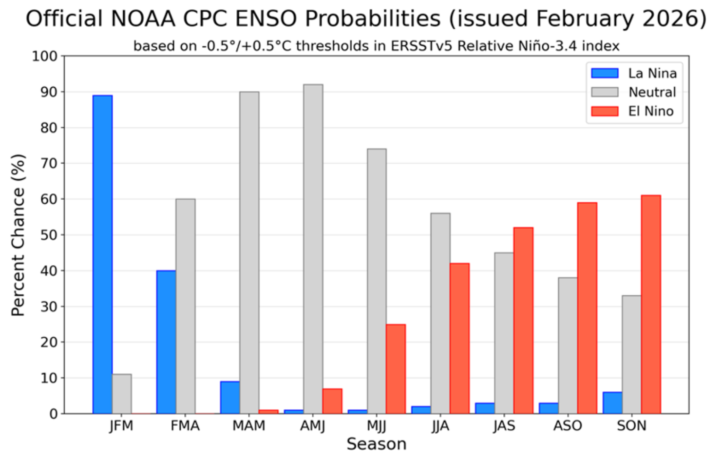
Historically, spring precipitation in Colorado tends to improve when La Niña weakens. Even a neutral pattern can open the door to healthier moisture, more frequent upslope events, and the kind of wet spring storms that would help rebuild our soil moisture and boost water supply heading into summer. A few bigger spring storms could make a meaningful difference, and the fading influence of La Niña improves our odds of seeing them. March and April are two of our snowiest months of the year, while April and May are our wettest.
But even with a few well‑timed storms, there is no clear path to recovering the massive snowpack deficit or the deepening drought across Boulder and much of Colorado. The Climate Prediction Center leans warm and dry for March–May across the Southwest — sadly including the Front Range.
Bottom Line: This Winter is a Warning
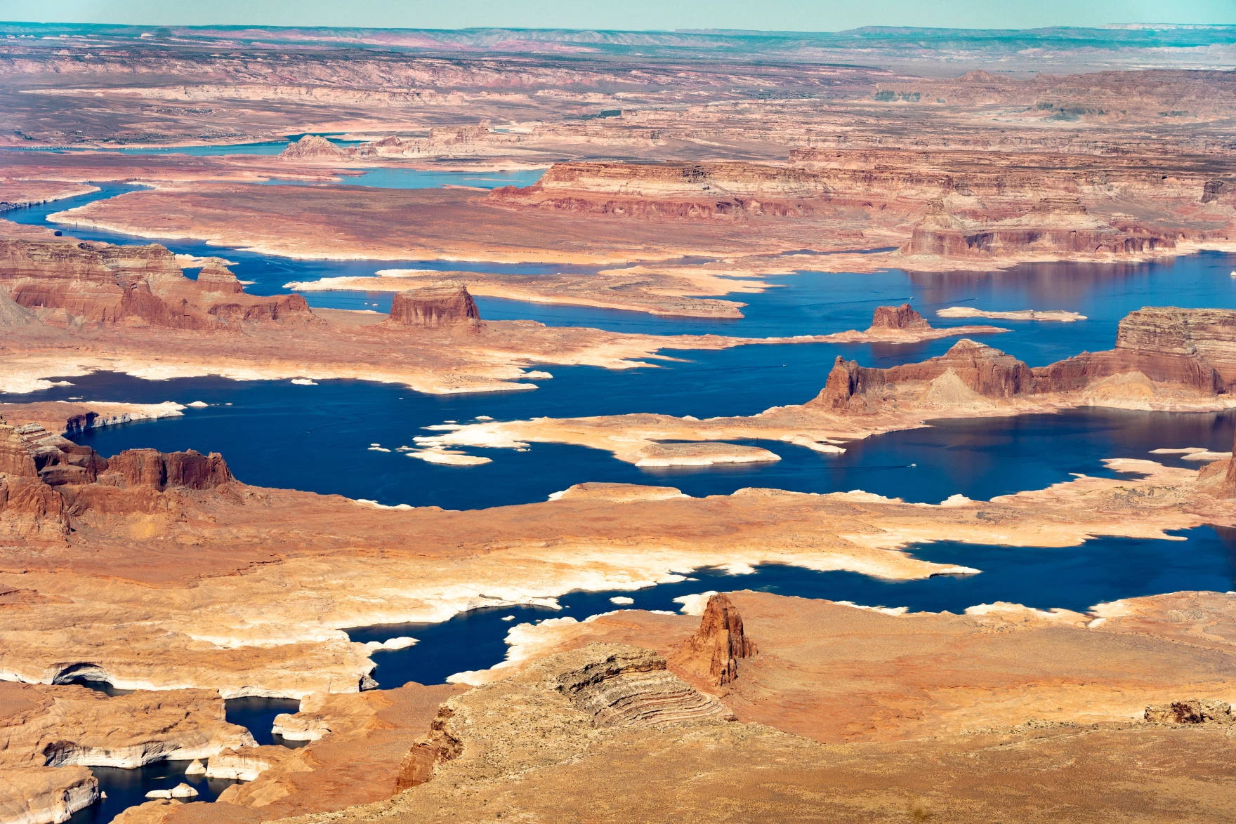
This winter wasn’t just a bit warm or slightly unusual. It was a complete failure of the cold‑season that the West depends on, and the consequences will extend far beyond a lack of snow along Colorado’s Continental Divide. When winter fails this profoundly, the disruption radiates outward through every system that relies on the steady rhythm of cold, snow, and gradual melt. Water managers lose the natural reservoir that mountain snowpack is supposed to provide, leaving cities, farms, and entire states in the Colorado River Basin facing increasingly uncomfortable decisions about how to stretch a shrinking supply. Reservoirs that should be quietly refilling through winter will instead stumble into this spring underfilled, offering far less protection against the triple punch of summer heat, irrigation demand, and wildfire suppression. Millions of Americans who depend on the Colorado River will feel the consequences of this winter long after our snow-starved peaks fade from the headlines.
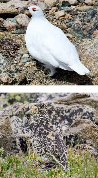
Nature is already showing signs of stress. Plants around Denver have begun budding months ahead of schedule, a gamble that could end disastrously for them if late‑season snow or deep freezes return — as they often do. Our drought‑stricken soils, deprived of insulating snow cover, have turned dry, sandy, and vulnerable to erosion. Wildlife that depends on snow for camouflage or insulation has been left exposed, forced to navigate a landscape that no longer matches the seasonal cues they evolved to rely on (like the white-tailed ptarmigan below). Even the timing and character of spring runoff — the lifeblood of rivers, wetlands, and riparian ecosystems — will be distorted this year. With snowpack so uneven and so shallow, runoff may arrive too early, too fast, or in pulses that fail to sustain waterways through the warm season. These disruptions don’t remain tucked away in the High Country. They cascade into agriculture, recreation, tourism, and the broader economy of the West. Ask the skiers, the lift operators, the restaurant workers, or anyone whose livelihood depends on Colorado’s Mountain towns — this winter has been brutal for them. They are only the first to feel the effects.
And then there’s fire, the threat that looms largest over a winter like this. A warm, snow‑starved season had primed the landscape for a fire year that will begin earlier, burn hotter, spread faster, and last longer. Fuels that should be buried under snow are instead drying months ahead of schedule. Without a meaningful snowpack to delay the onset of summer heat, the region will become a tinderbox just waiting for a careless spark or monsoon lightning bolt. Large, fast‑moving wildfires peppered across the West could easily overwhelm available resources, and the impacts won’t be confined to burn scars. Smoke will drift across state lines, settling into valleys and cities, degrading air quality across the entire West. Colorado will inhale smoke from its own fires and from those burning many hundreds of miles away, a reminder that in a warming climate, fire seasons are no longer just local events — they can become broader regional crises.
What we lived through this year was not simply just another warm winter; it was a preview of a climate system that could be losing its seasonal anchors. The atmosphere is about to show us how easily a single disrupted winter in the West can reverberate through the water supply, ecosystems, public health, and the stability of entire communities. Without a meaningful pattern shift this spring — and right now, the signals we’re seeing offer little reassurance — we will enter the warm season carrying deficits that won’t just shape the spring ahead, but will echo through the rest of 2026. This winter wasn’t just unusual. It is a warning for the entire West — a clear signal that the systems we’ve long depended on are starting to strain under conditions they were never designed to handle. The coming months will reveal whether our infrastructure, our water management strategies, and even our assumptions about seasonal reliability are resilient enough to withstand what this failed winter has already set in motion.
Spread the word, share our crazy Colorado weather:
Go Premium, get all the perks.
Daily Forecast Updates
Get our daily forecast discussion every morning delivered to your inbox.
All Our Model Data
Access to all our Colorado-centric high-resolution weather model graphics. Seriously — every one!
Ski & Hiking Forecasts
6-day forecasts for all the Colorado ski resorts, plus more than 120 hiking trails, including every 14er.
Smoke Forecasts
Wildfire smoke concentration predictions up to 72 hours into the future.
Exclusive Content
Weekend outlooks every Thursday, bonus storm updates, historical data and much more!
No Advertisements
Enjoy ad-free viewing on the entire site.


That was a remarkable post, and truly concerning. I don’t recall living through a winter like this.
Thank you for your hard work on this article! I learned a ton and it gave me insight I’ve been wondering about for a long while.
I wish there was something that could be done to prepare and behave preventively for the fire and drought. Any pro tips for decision makers reading this?
Incredible, and incredibly frightening, explanation of the significance and implications of this unusual winter – that will likely become all the more common in the future. Thank you for the thoughtful writeup.