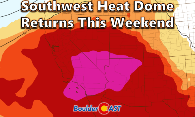
After a lively stretch of monsoon storms and even some flooding across the state, the atmosphere is shifting in a way that favors heat, haze, and a temporary shutdown of our storm pipeline for the Front Range. A stout Southwest heat dome is about to take center stage, triple‑digit temperatures are lining up for Boulder and Denver, and wildfire smoke is poised to make an unwelcome return. We break down the ridge, the records, the smoke, and the eventual cooldown.
Category: Forecast (Page 1 of 169)
Eastern Colorado just came off a truly blistering weekend, with Denver and Boulder both shattering daily records as temperatures surged past 100°F on back‑to‑back days. Now the pattern is shifting, at least temporarily. An unusually juiced monsoon plume will set the stage for more robust afternoon storms through mid‑week, including a legitimate threat for locally heavy rainfall and burn‑scar flooding. But the faucet will shut off quickly. A rapidly intensifying Southwest heat dome will retrograde into Arizona late‑week, cutting off monsoon flow, drying out northern Colorado, and potentially steering wildfire smoke from the Pacific Northwest into the state as winds shift. By the weekend, the Front Range will sit on the fringe of that expanding heat dome, meaning another round of hot, dry weather and potential triple-digit readings again. Read on for all the details.
A surge of true monsoon moisture is finally breaking through the Front Range’s persistent dry shield. After Tuesday night’s northern‑tier storms offered a preview, the next two days will bring the real deal: widespread convection, highly anomalous moisture, torrential rainfall rates, and the best shot at real rain we’ve had in weeks. If you’ve been waiting for a break from the seemingly never-ending heat of summer and a return of stormy skies, the next few days are poised to deliver.
After more than a week of relentless heat, the Front Range is finally heading into a pattern change — but not before we break a few records and squeeze out one more day near 100°. This week will bring a notable shift: true monsoon moisture is poised to surge over the Continental Divide, storm chances finally return and temperatures finally ease… at least for a moment. We break down what’s driving this stubborn heat, when the storms arrive, and why flash-flood concerns may quickly replace heat and fire danger as Colorado’s primary weather story.
Summer isn’t just knocking, it’s kicking the door wide open across the Front Range this week. An unusually stubborn ridge of high pressure is staying put overhead, sending temperatures soaring across the Denver Metro area for days to come with barely a cloud in the sky. Fire danger, air quality, and even the long‑awaited monsoon will all play a role eventually this week. We break down what this pattern means for heat records, fire concerns, and when rain chances might finally return to the area.
A powerhouse heat dome is about to sprawl across the entire country, and while Colorado’s Front Range won’t sit dead-center in the bullseye, we’re still in for a long, stubborn stretch of serious heat. Daytime temperatures will soar into the middle 90s to low 100s, with warm nights that barely cool off, and skies so clear you might just forget what a cloud looks like.
A subtle shift in the ridge’s position will save Denver and Boulder from the truly unprecedented temperatures that some weather apps and models were flashing earlier this week — but the stage will be set for a scorching Western Slope, lingering fire concerns, and a delayed monsoon that is just now trying to claw its way north. We break down what’s coming, where the heat will hit hardest, and when relief might finally show up.
This week several large wildfires will continue to slowly grow across Colorado as smoke remains stubbornly locked over the Front Range, and a heat dome building for the upcoming weekend will be downright punishing. But there is light at the end of the hot and smoky tunnel — the now-delayed 2026 monsoon will make its triumphant return next week. Read on for all the details.
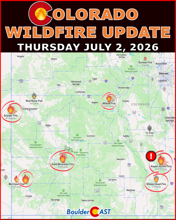
We provide a brief status update on the largest and most impactful wildfires burning across Colorado as of Thursday July 2, 2026 at 10AM.

Live View of Boulder

Current Conditions

Live Radar

Latest Smoke Forecast

Recent Premium Posts

BoulderCAST Daily – Fri 07/31/26 | Marginal Risk of Severe Storms with Smoke and Haze
🌧️ Isolated Storms — This afternoon and evening, with a marginal risk of …
BoulderCAST Daily – Wed 07/29/26 | Final Storm‑Filled Afternoon Before an Expanding Desert Southwest Heat Dome Takes Over
🌧️ Lingering Monsoon Moisture — Lingering Tap One last day of beneficial rainfall …
BoulderCAST Daily – Tue 07/28/26 | Front Range Primed for Widespread Thunderstorms as Monsoon Reloads
🌩️ Monsoon moisture surge — Deep moisture availability today, both aloft and at …
3-Day Forecast

Trending Content

© 2026 Front Range Weather, LLC