


A powerhouse heat dome is about to sprawl across the entire country, and while Colorado’s Front Range won’t sit dead-center in the bullseye, we’re still in for a long, stubborn stretch of serious heat. Daytime temperatures will soar into the middle 90s to low 100s, with warm nights that barely cool off, and skies so clear you might just forget what a cloud looks like.
A subtle shift in the ridge’s position will save Denver and Boulder from the truly unprecedented temperatures that some weather apps and models were flashing earlier this week — but the stage will be set for a scorching Western Slope, lingering fire concerns, and a delayed monsoon that is just now trying to claw its way north. We break down what’s coming, where the heat will hit hardest, and when relief might finally show up.
What You Need to Know
- Major National Heatwave — A sprawling, high-end ridge will dominate the country for 7–14 days, with Colorado avoiding the worst of things but still facing persistent, above-normal heat.
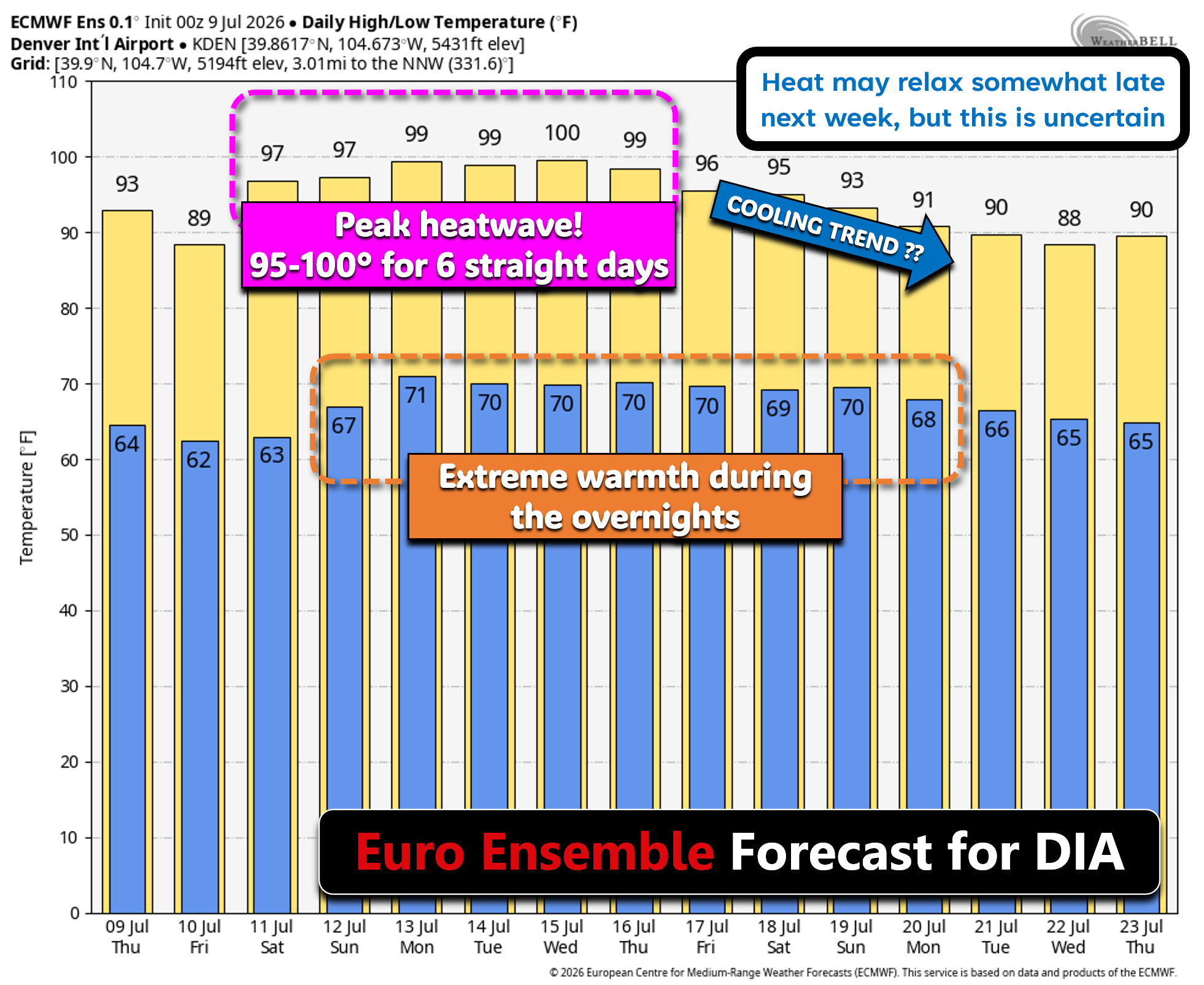
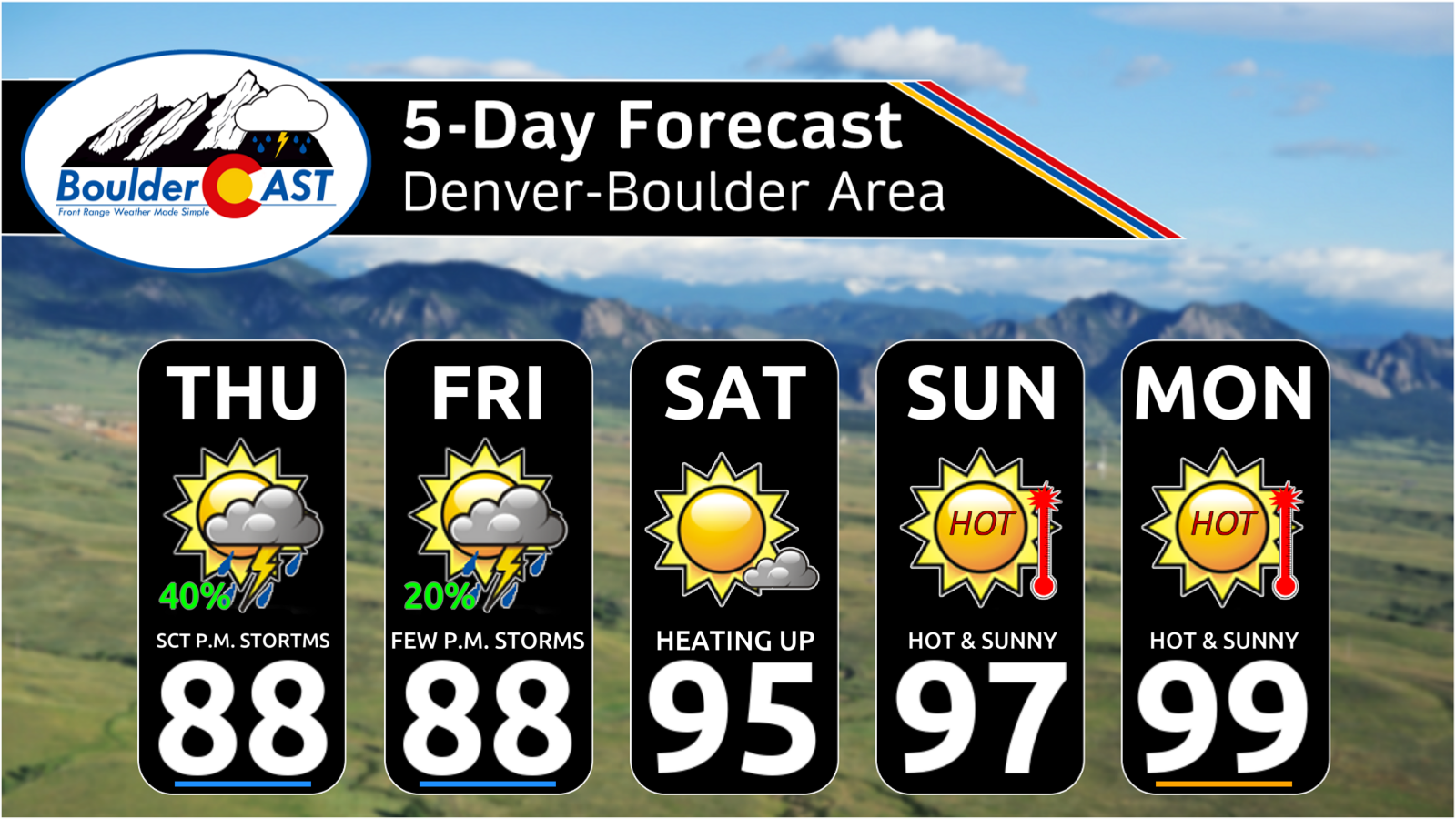
- Front Range Temperature Impact — Expect a long string of daily highs reaching 95–100°F and overnight lows near 70°F, limiting natural cooling and making homes harder to ventilate at night. The heat begins on Saturday.
- Western Slope Really Sizzles — Downslope warming west of the Divide will push temperatures way above normal, making northwest Colorado and the Western Slope the most anomalously hot parts of the state.
- Dry, Cloudless Stretch — Strong subsidence under the ridge will wipe out precipitation chances and even cloud cover across eastern Colorado for many days, producing bone-dry air and full sunshine.
- Fire Weather Concerns — Hot, dry conditions will elevate fire danger across the Four Corners, with the added risk of dry lightning next week if monsoon moisture arrives aloft without a surface reflection.
- Monsoon Moisture Return Window — Early signs point to moisture rotating into Colorado around July 16–18, offering a return chance of storms but not guaranteeing widespread rainfall.
- Late but Not Lost Monsoon — Despite the delayed start, ensemble guidance still supports a more active monsoon pattern developing in late July and lingering into August.
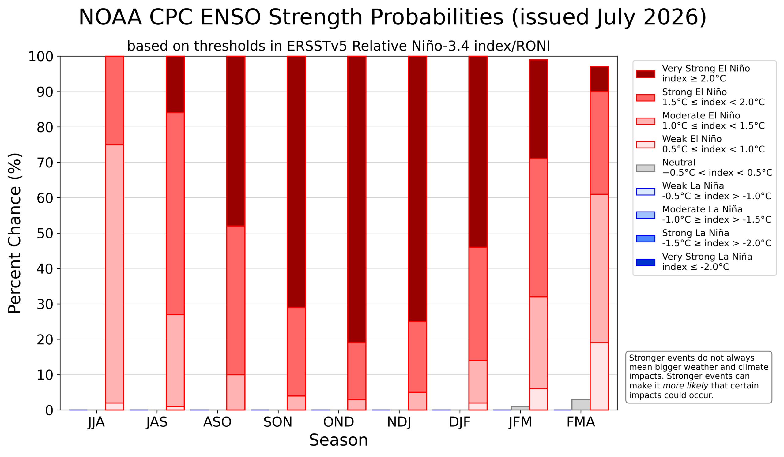
- Strong El Niño Inbound — A rapidly strengthening strong El Niño tilts the odds toward wetter-than-normal conditions for the Front Range later this summer into fall, something that historically boosts precipitation in our area most months of the year.

Go Premium, get all the perks.
Daily Forecast Updates
Get our daily forecast discussion every morning delivered to your inbox.
All Our Model Data
Access to all our Colorado-centric high-resolution weather model graphics. Seriously — every one!
Ski & Hiking Forecasts
6-day forecasts for all the Colorado ski resorts, plus more than 120 hiking trails, including every 14er.
Smoke Forecasts
Wildfire smoke concentration predictions up to 72 hours into the future.
Exclusive Content
Weekend outlooks every Thursday, bonus storm updates, historical data and much more!
No Advertisements
Enjoy ad-free viewing on the entire site.
Quick Update: Saturday July 11th at 8:00 AM
Good Saturday morning, everyone!
The well‑advertised heatwave has officially arrived, for better or worse.
Our thinking hasn’t changed much on how this prolonged burst of summer warmth will play out. The good news: the Front Range will dodge the most extreme heat, while areas to our north and west face far more anomalous, and in some cases dangerous, conditions.
A few quick updates for the Boulder–Denver area:
- 🧊 The “cooler” scenarios continue to look more likely (thanks upslope!).
- 😀 We’re still not expecting any widespread 100° readings (a few hot spots will get there).
- 🏆 No record highs are expected to be set in the Denver area.
- 🌞 Very few clouds east of the Mountains for days on end.
- 💦 No rain chances until around Friday July 17th as monsoon moisture creeps into the area.
- 💥 Heatwave won’t crack until at least next weekend (July 18-20).
The Heatwave Catalyst: A Huge Ridge as Strong as They Come
Asprawling, high‑end heatwave is gearing up to engulf much of the nation this weekend into next week. Denver won’t take the brunt of it, but make no mistake — this will be a long-duration event with persistent, above‑normal heat across the state.
At the center of it all is a remarkably strong mid‑level ridge building over the Four Corners. By Sunday and Monday, this ridge will expand into a full‑blown continental-scale heat dome, dominating the weather from Los Angeles to New York City. Model guidance continues to advertise a 500mb height center exceeding 6000 meters, which is near the upper limit of what North American ridges typically can achieve. When heights get this high, the atmosphere cannot produce much else besides extreme heat.
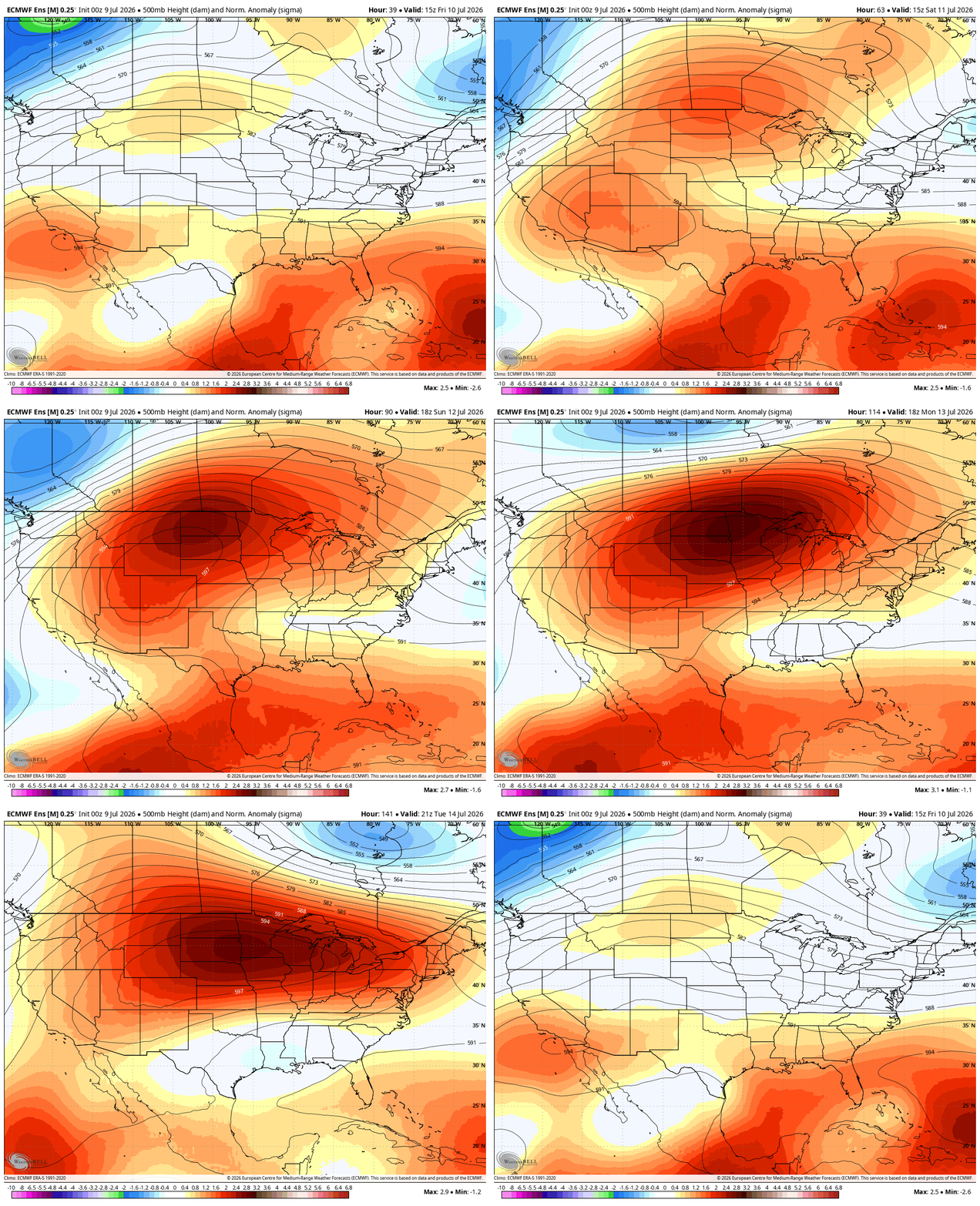
Fortunately for the Front Range, the massive ridge’s core is now projected to settle north and east of Colorado early next week — a subtle but crucial shift.
Why This Shift Matters: Upslope vs. Downslope
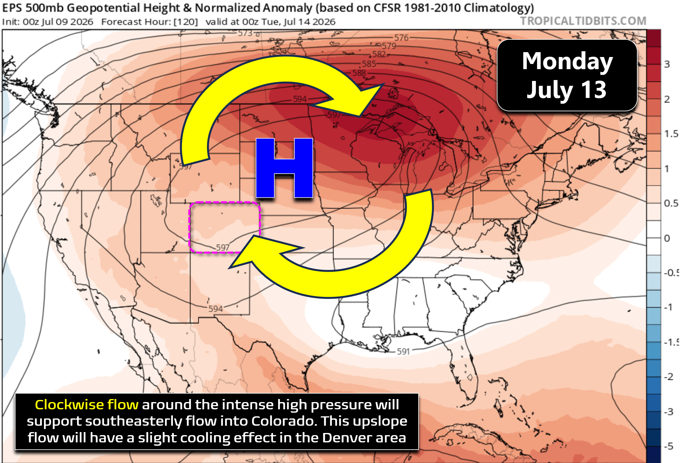
Clockwise flow around the ridge will deliver southeasterly to southerly winds through the lower half of the atmosphere in our area for many days. East of the Divide, that’s upslope, which will provide a small but meaningful cooling influence.
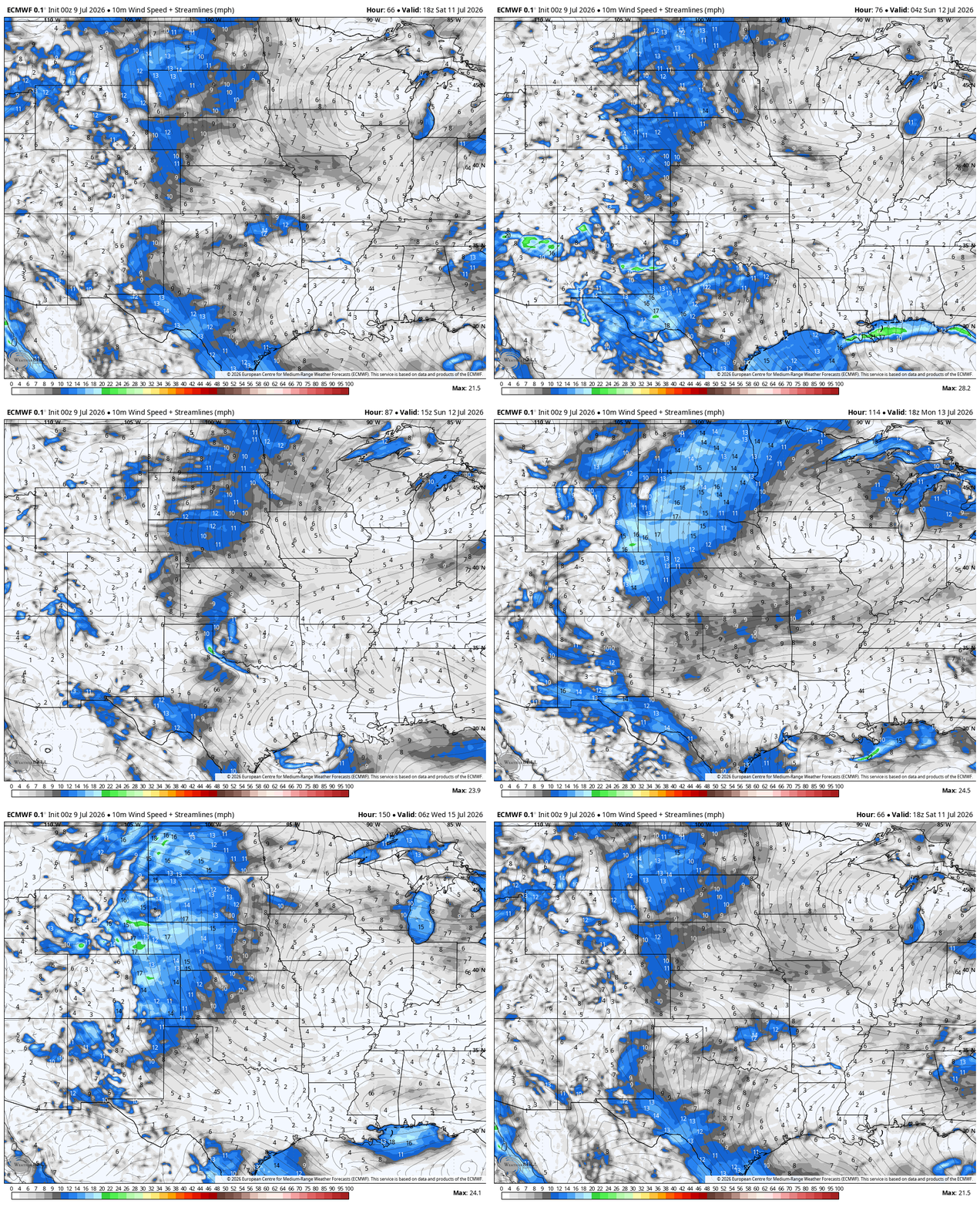
This is the key difference between:
- Earlier model runs → ridge centered farther south → southwesterly downslope into Denver → hotter, potentially record‑shattering temperatures
- Current model runs → ridge centered farther north → southeasterly upslope → several degrees of cooling instead of warming
This is why some weather apps and media outlets were advertising 107°+ earlier this week for Denver during the upcoming heatwave. That scenario required a downslope‑enhanced heatwave—and we were oh-so-close to that outcome.
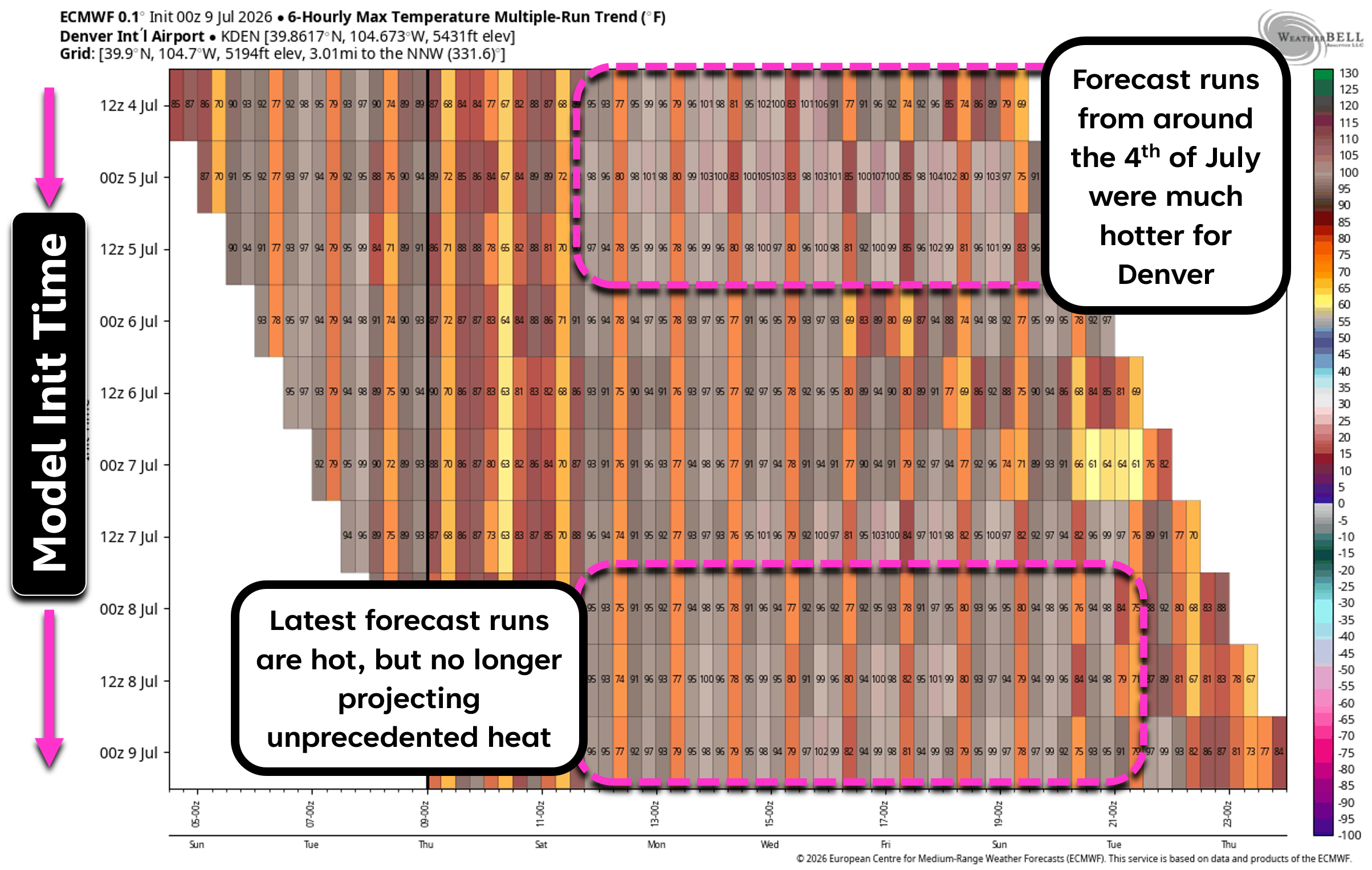
The takeaway: The Front Range is likely to narrowly dodge the worst‑case setup this time, but those earlier model runs did give us a crystal‑clear look at the exact pattern capable of smashing all‑time temperature records up and down the Urban Corridor. And we came uncomfortably close to seeing it unfold, sidestepping what could have been the second such unprecedented Colorado heatwave in 2026. We may not be so lucky next time.
Where the Worst Heat Will Actually Land
With the ridge displaced northward, the most anomalous temperatures will target:
- The Dakotas
- Montana
- Wyoming
- Idaho
- Utah
- And yes, Northwest Colorado & the Western Slope
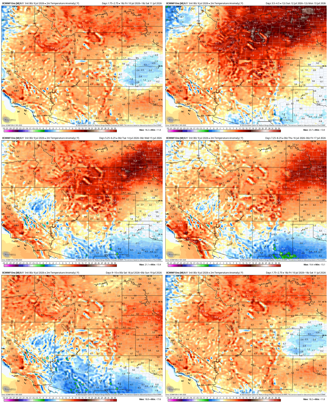
Remember that southeasterly flow is upslope for Denver, but downslope west of the Divide. That means places like Granby, Steamboat, Craig, Rifle, and Grand Junction will roast under compressional warming. Strong temperature anomalies of 10 to 18° will be common in these areas. Boulder and Denver will see anomalies more in the range of 7 to 13° during the heatwave.
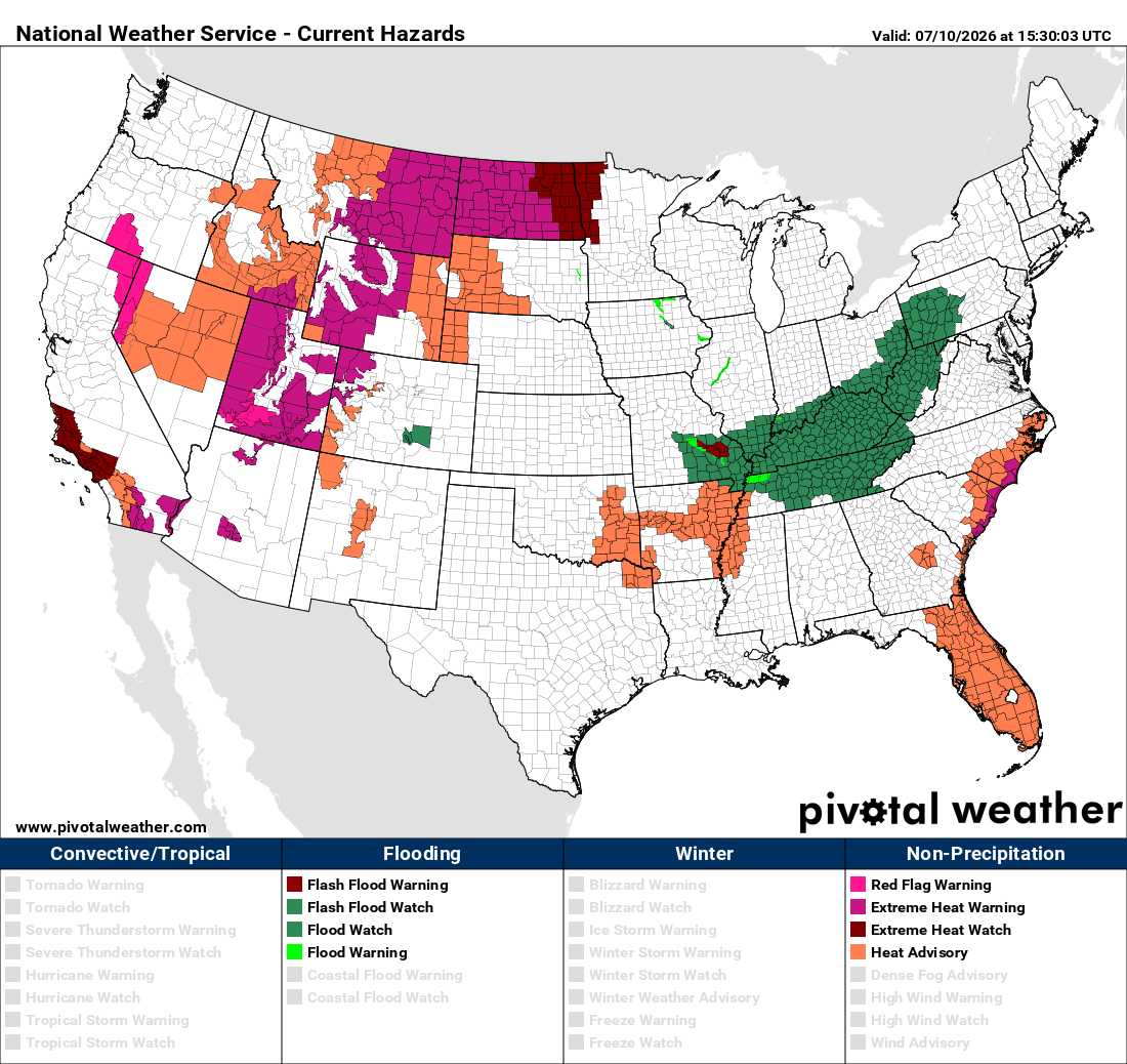
Heat-related Watches, Warnings and Advisories are already spreading across the West. Our area will likely join the “colorful” party by early next week, too.
So… How Hot Will It Get Along the Front Range?
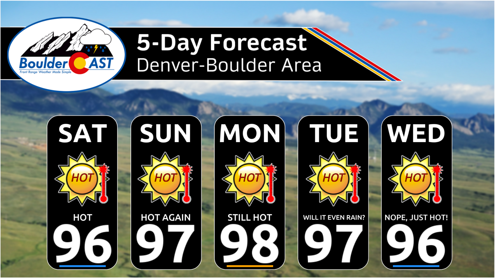
Latest model guidance points toward about one week straight with daily max temperatures sitting between 95 and 100° in the Front Range, beginning on Saturday. The European ensemble mean temperature forecast is shown below. The usual hot spots could reach into the low triple digits a few times, such as Greeley, Longmont and even downtown Denver. Overnight lows will be pretty brutal as well, not dropping much below 70° for many nights in a row. This will mean the usual tricks of opening the windows or turning on a whole-house fan won’t be effective after dark during this heatwave. Outside of aggressive use of air conditioning, relief from this heatwave will be hard to come by.
The GFS ensemble forecast remains equally relentless—if not worse—showing little to no meaningful cooling late next week and, in fact, projecting the hottest temperatures during that period. Unfortunately, to be honest, at this point we don’t yet know when to expect an end to this heatwave. Things could start to improve around next Thursday, or it could be many days beyond that. Such a hot airmass is being cooked up under this ridge that even after it weakens, the heat may linger unless a significant cold front can find its way into eastern Colorado. We’re just not seeing that yet.
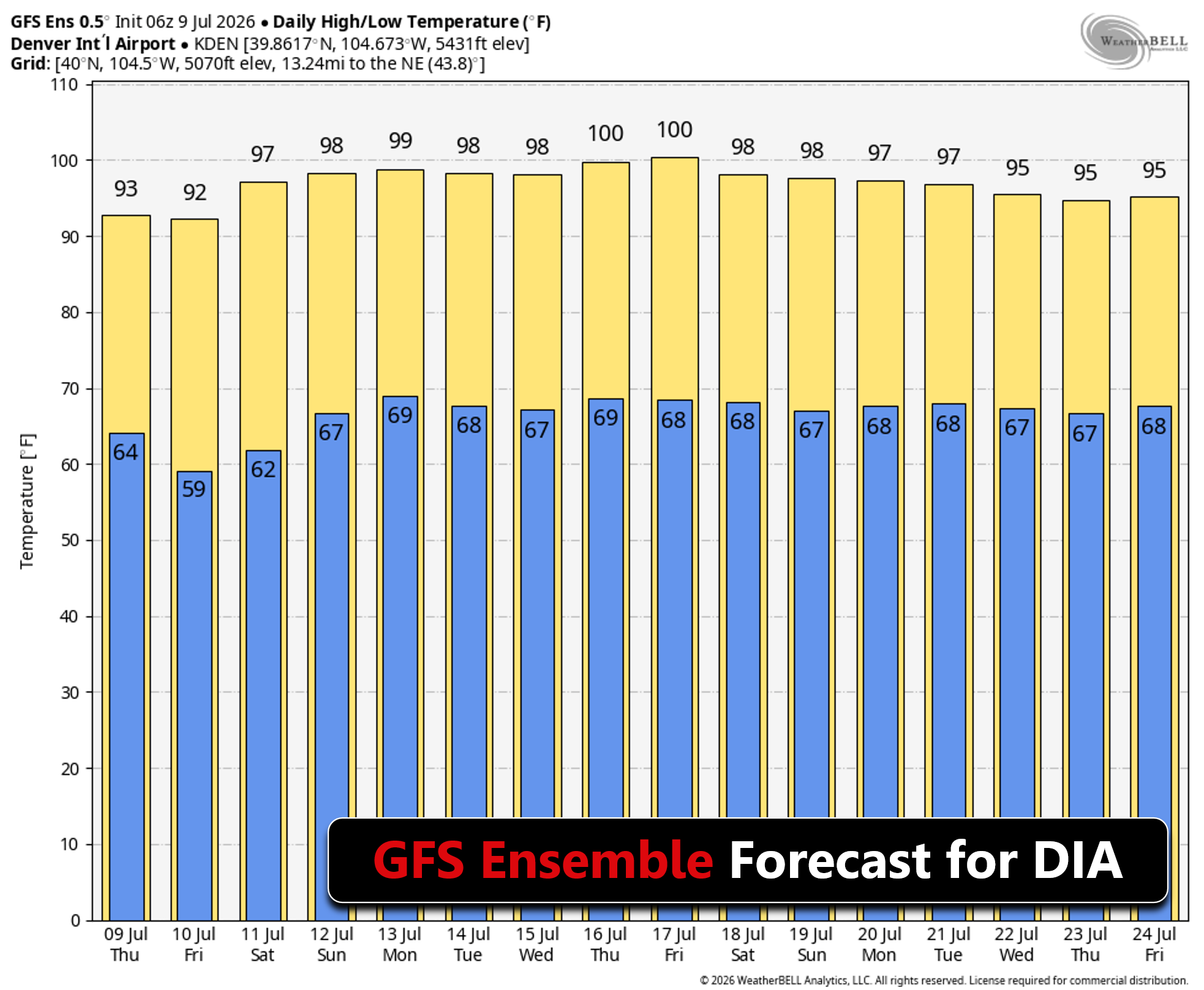
Our confidence is high for the next week: This will be a long-lasting heatwave, likely 6–10+ days depending on how quickly the ridge breaks down and what happens with an area of low pressure forecasted to retrograde beneath it. This heatwave is not shaping up to be historic in magnitude here, but it will be relentless.
Where’s the Rain?
Underneath the impressive ridge, broad subsidence will drag exceptionally dry mid-level air downward, wiping out cloud cover and precipitation chances across eastern Colorado.
Expect:
- Multiple days with zero clouds
- Zero meaningful precipitation
- Solar panel homeowners will feast
This is expected heat-dome behavior after all: sinking motion, drying air, and a complete shutdown of any meaningful convective processes.
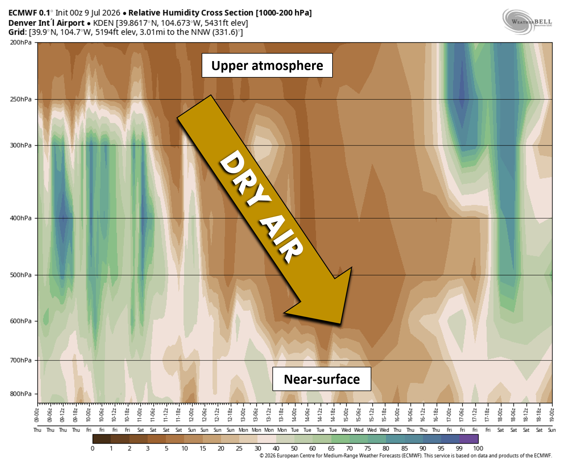
With this level of heat and dryness locked in, fire‑weather concerns naturally ramp up, and smoke transport becomes part of the conversation. The good news for the Denver–Boulder area is that the same broad southeasterly flow helping to temper our temperatures will also steer any smoke from existing or new Western fires away from the Front Range, keeping fine particulate air quality impacts fairly minimal during the heatwave. Good news for those with sensitive respiratory systems as smoke and heat would be a nasty combo. Ozone concentrations under this stable sinking setup could get pretty high during the event, though.
Monsoon Moisture: A Complicated Potential Benefit
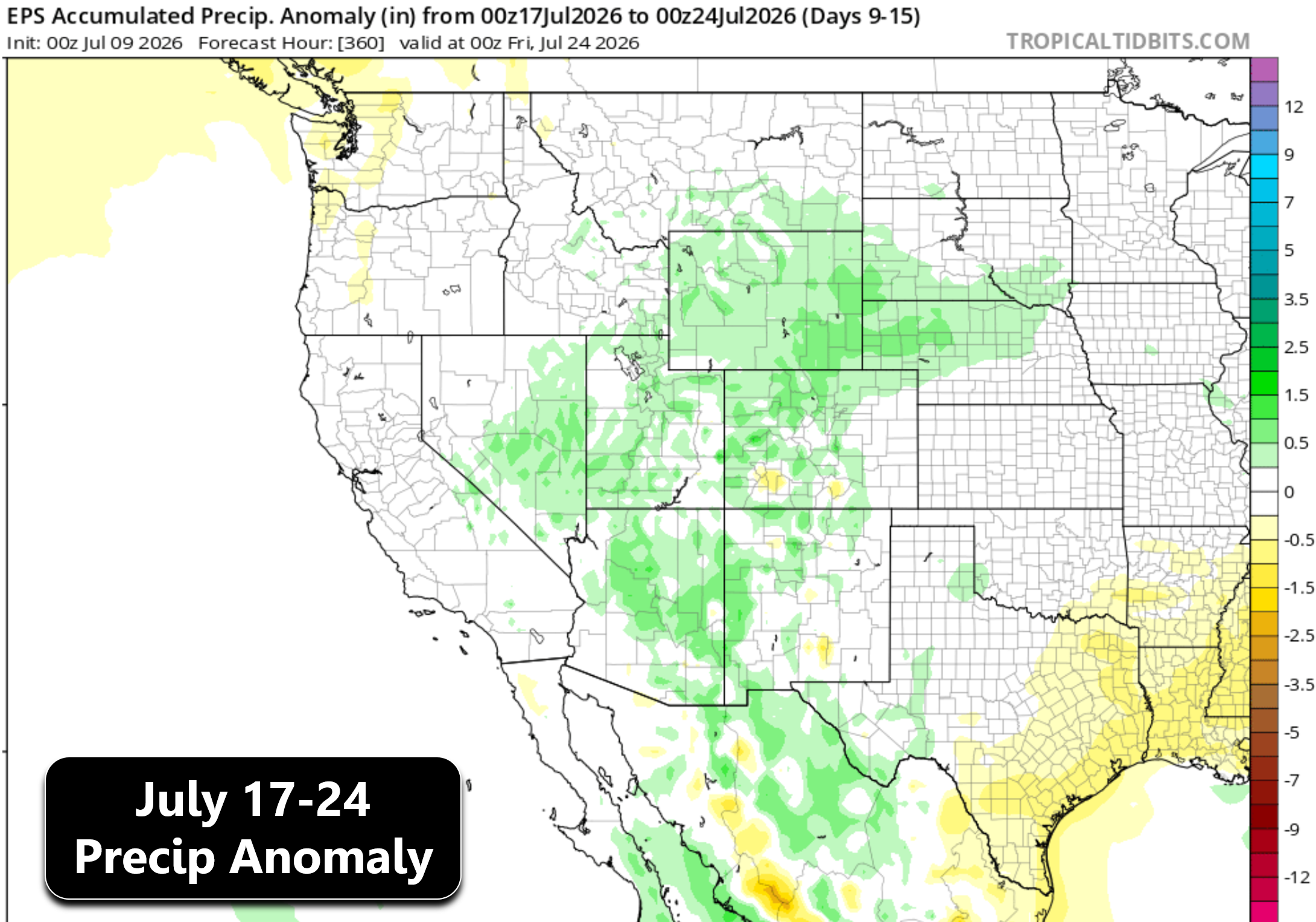
As we’re absolutely baking in the Front Range during the heatwave, moisture will begin pooling north on the western flank of the ridge — the early stirrings of monsoon season.
With this there will be two possibilities:
- If moisture reaches down to the surface: → the West will see legitimate storm chances returning to the forecast which may aid in drought recovery over time.
- If moisture stays elevated: → the West will see generally drier storms and pockets of dry lightning, which is a wildfire ignition concern.
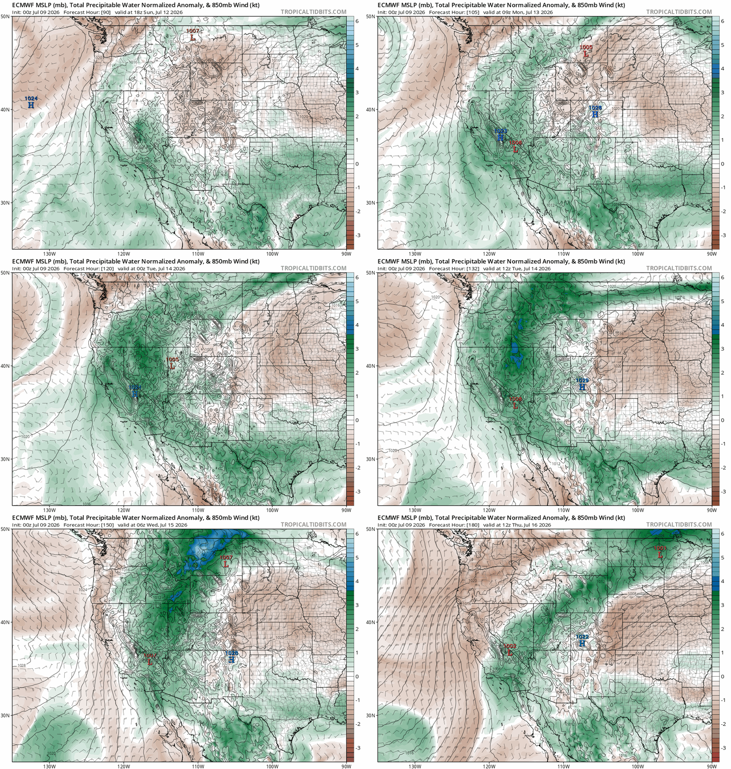
All of this moisture will initially stay well to our west across California and Nevada, but eventually it should rotate into parts of Colorado around the latter part of next week. This doesn’t necessarily mean we’re going to a see a huge deluge of rain or anything (yet), but at least precipitation chances should return to the forecast as this moisture works back into the area around July 16th to 18th.
After the ridge finally breaks down, ensemble guidance continues to support a fully active monsoon for the Southwest heading into late July.
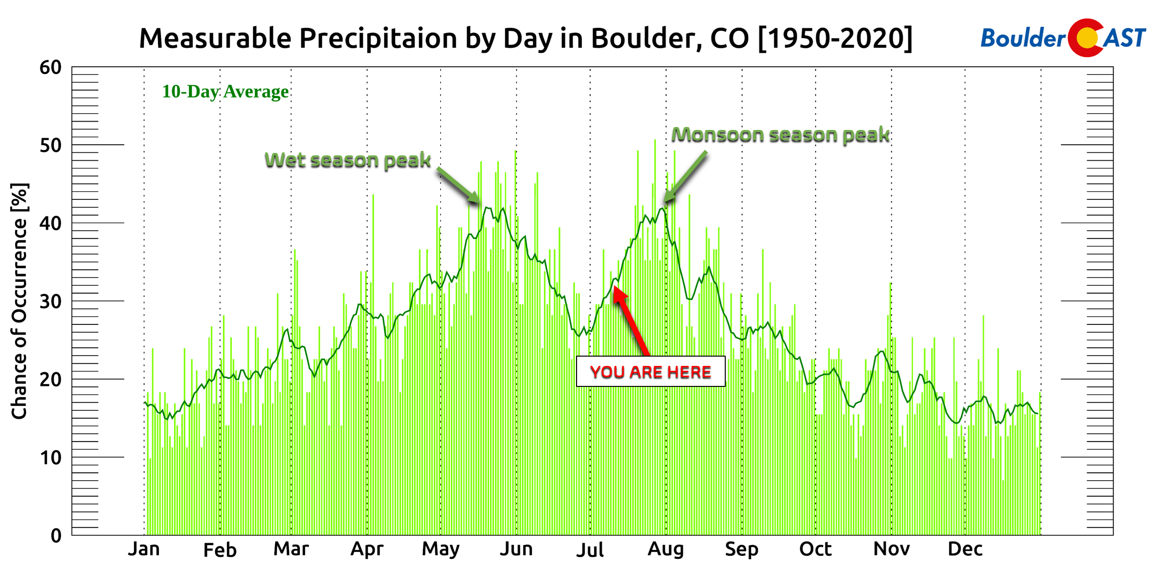
Monsoon Perspective: Yes, It’s Late — But Not Alarming Yet
Despite the negativity floating around social media regarding the delayed monsoon, there’s no major cause for concern at this stage.
- Monsoon season typically starts showing life in early to mid July
- It peaks in late July
- But often lingers into late August
We’re running a bit late, and the heatwave will delay things further — but the monsoon pattern is not lost yet.
And with a rapidly strengthening El Niño in the Pacific, the odds tilt toward wetter-than-normal conditions for the Front Range as we move deeper into summer. Is that guaranteed? Of course not — long-range forecasting never is.
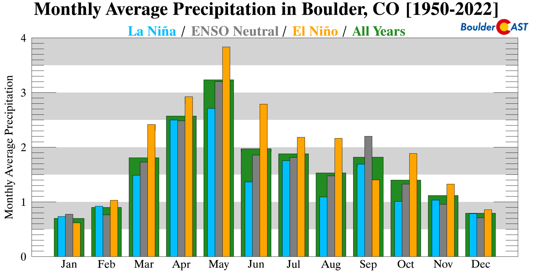
But historically, on average El Niño gives Boulder above-normal precipitation 10 out of 12 months of the year.
Bottom Line
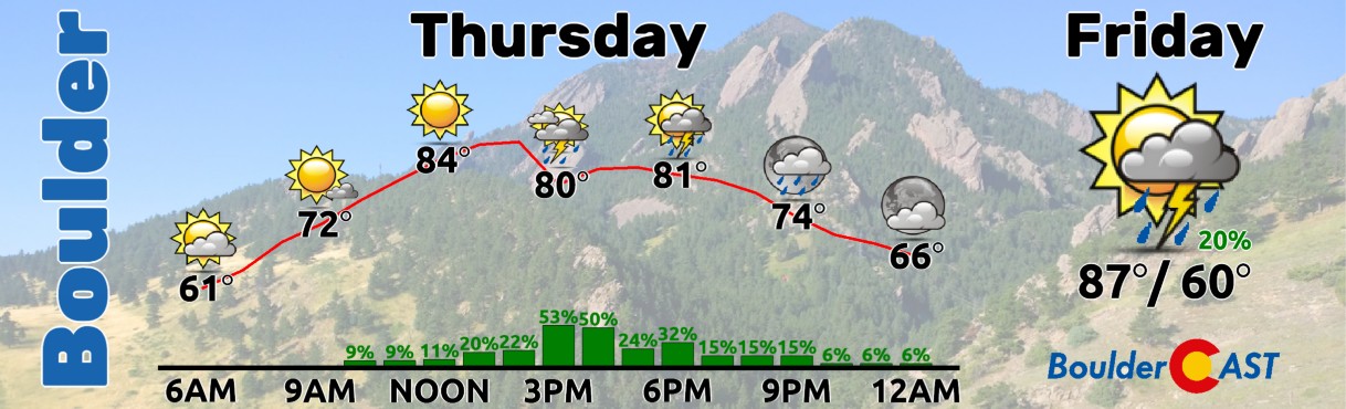
Front Range Colorado will sidestep the most extreme anomalies of the brewing national heatwave, but we’re still staring down a long, relentless stretch of 95–100°F heat coincident with poor overnight relief and essentially no precipitation for at least a week. Upslope flow will keep Denver and Boulder from hitting the truly historic numbers seen in earlier model runs, but northwest Colorado and the Western Slope will sizzle under downslope‑enhanced heat running 10–18°F above normal and heading for potential all-time record highs. During this heatwave, expect bone‑dry air, cloudless skies, elevated fire danger, and limited nighttime cooling. Today and Friday will feature a chance of late-day storms and also land relatively cooler than what is looming down the road, but not “cool” by any means. Enjoy the more pleasant near-term weather while you can!
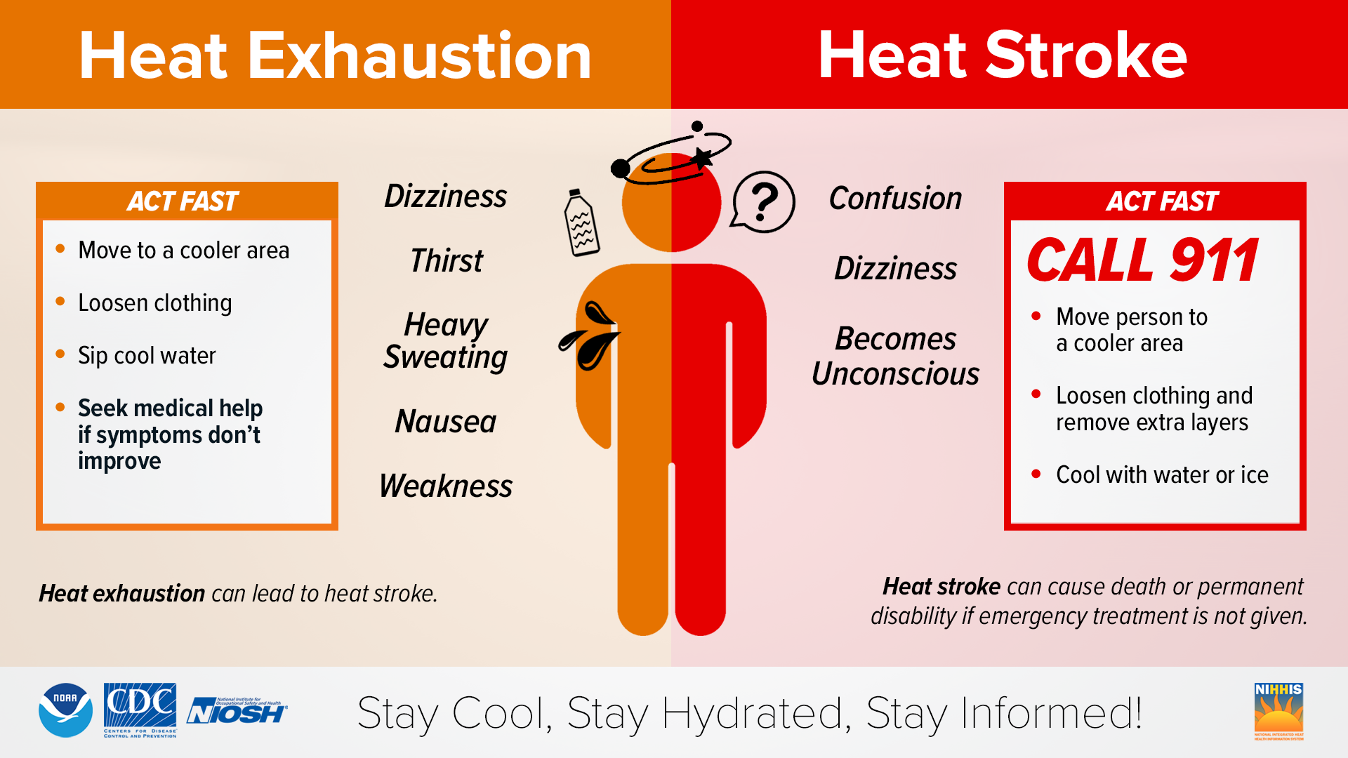
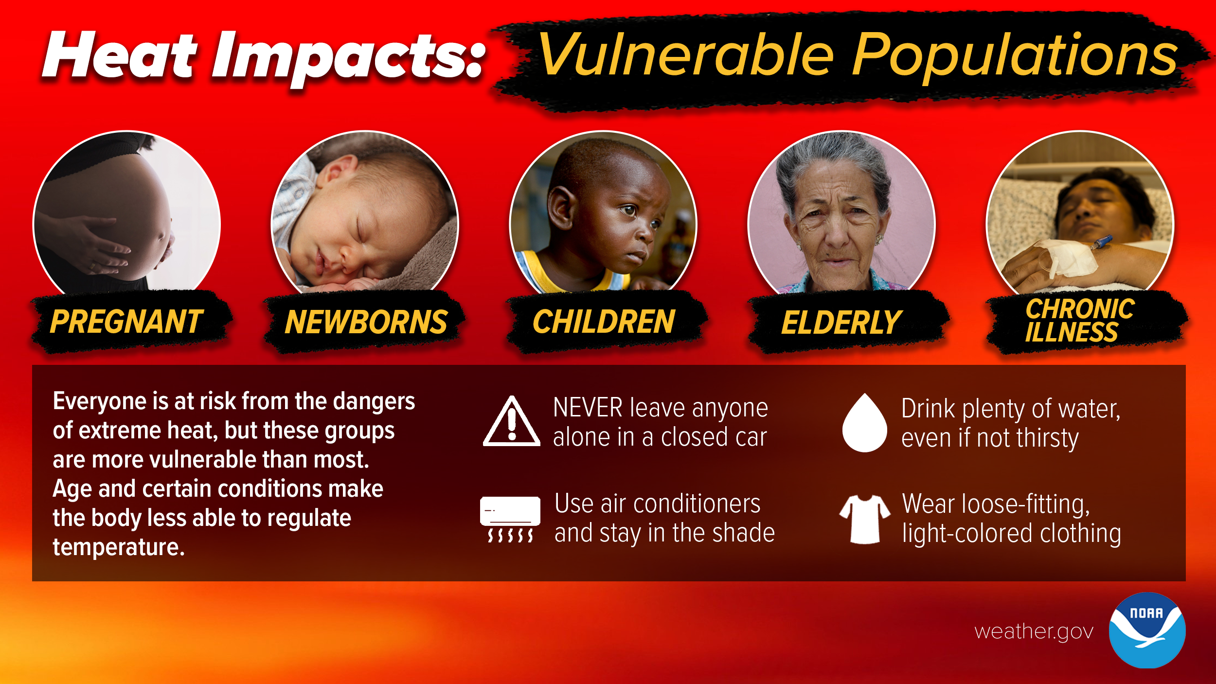
The stretch of heat ahead will demand some basic safety awareness. Stay hydrated throughout the daytime, limit strenuous outdoor activity during the hottest afternoon hours, and check on neighbors who may struggle with prolonged warmth. Keep indoor spaces cool early, avoid relying on nighttime ventilation, and never leave pets or kids in vehicles — even briefly. This isn’t historic heat, but it’s persistent, and respecting it will make a real difference. Stay cool, stay safe, and look out for one another.
Spread the word, share our crazy Colorado weather:
Go Premium, get all the perks.
Daily Forecast Updates
Get our daily forecast discussion every morning delivered to your inbox.
All Our Model Data
Access to all our Colorado-centric high-resolution weather model graphics. Seriously — every one!
Ski & Hiking Forecasts
6-day forecasts for all the Colorado ski resorts, plus more than 120 hiking trails, including every 14er.
Smoke Forecasts
Wildfire smoke concentration predictions up to 72 hours into the future.
Exclusive Content
Weekend outlooks every Thursday, bonus storm updates, historical data and much more!
No Advertisements
Enjoy ad-free viewing on the entire site.












You must be logged in to post a comment.