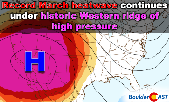
Wednesday’s remarkable 80° warmth marked the start of a stretch that’s far more reminiscent of early summer than mid‑March here in Colorado. An unusually strong ridge of high pressure is now locked over the region, setting the stage for several more days of exceptional heat with widespread record temperature destruction and increasing fire concerns. A brief cooldown will arrive over the weekend, but the broader pattern remains firmly tilted toward above‑normal temperatures the rest of the month, including a secondary heatwave already brewing for next week. Here’s a look at how this historic heatwave setup will unfold across the Front Range in the many days ahead.
What You Need to Know
- 🥵 Historic March heatwave: Mid‑March temps surged into the lower 80s on Wednesday, delivering Boulder’s warmest March day since 1910 and smashing record highs across the Front Range.
- 🌡️ Unprecedented ridge: A 5950‑meter 500mb ridge—more typical of late June—will keep extreme warmth locked in through Saturday.
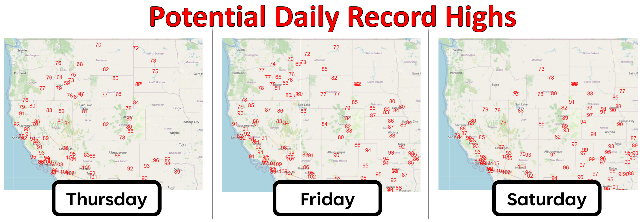
- 📈 More records coming: Highs today and Friday reach 83–86°F, with many cities poised to break all‑time March records. Saturday will be the hottest day near 90°F.
- 🔥 Fire danger on the rise: Red Flag Warnings near Wyoming Border on Thursday, with Saturday shaping up as the most dangerous fire‑weather day regionwide—humidity <10%, wind gusts 30+ MPH, and highs close to 90°F.
- 🌧️ Brief Sunday cooldown: A weak front drops temps into the 60s with a chance for light, nearly meaningless rain showers.
- 🔄 Heat returns in force next week: The hot airmass will reload early next week, bringing another stretch of 80s, more records to be broken, and renewed fire danger.

Go Premium, get all the perks.
Daily Forecast Updates
Get our daily forecast discussion every morning delivered to your inbox.
All Our Model Data
Access to all our Colorado-centric high-resolution weather model graphics. Seriously — every one!
Ski & Hiking Forecasts
6-day forecasts for all the Colorado ski resorts, plus more than 120 hiking trails, including every 14er.
Smoke Forecasts
Wildfire smoke concentration predictions up to 72 hours into the future.
Exclusive Content
Weekend outlooks every Thursday, bonus storm updates, historical data and much more!
No Advertisements
Enjoy ad-free viewing on the entire site.
The Historic Heatwave Rolls On…
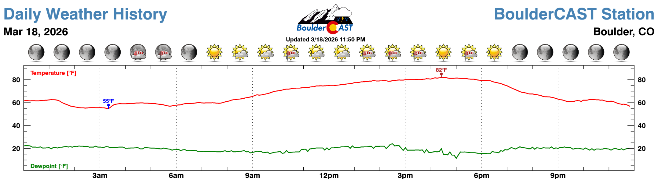
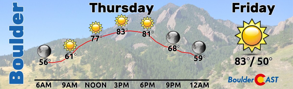
Wednesday’s heat was nothing short of extraordinary for mid‑March, and that was only the beginning of our heatwave. High temperatures surged into the lower 80s across nearly every Front Range city, with our Boulder station topping out at 82°F around 4:30 PM. While the official number isn’t available yet, Wednesday almost certainly ranks as Boulder’s second‑warmest March day on record—and the warmest since 1910. Nearby observing sites corroborate the magnitude of the warmth: 83°F at the NCAR Foothills Lab, 82°F at Boulder Municipal Airport, and 82°F on CU’s East Campus.
Little meaningful change in our weather is expected in the coming days. We remain firmly entrenched beneath an exceptionally strong and unusually symmetric ridge of high pressure centered over southern Arizona. This ridge is projected to peak near 5950 meters at 500mb, a geopotential height field more typical of late June than the final days of winter. For context, 5950 meters is well beyond what has ever been observed in the continental United States in March.
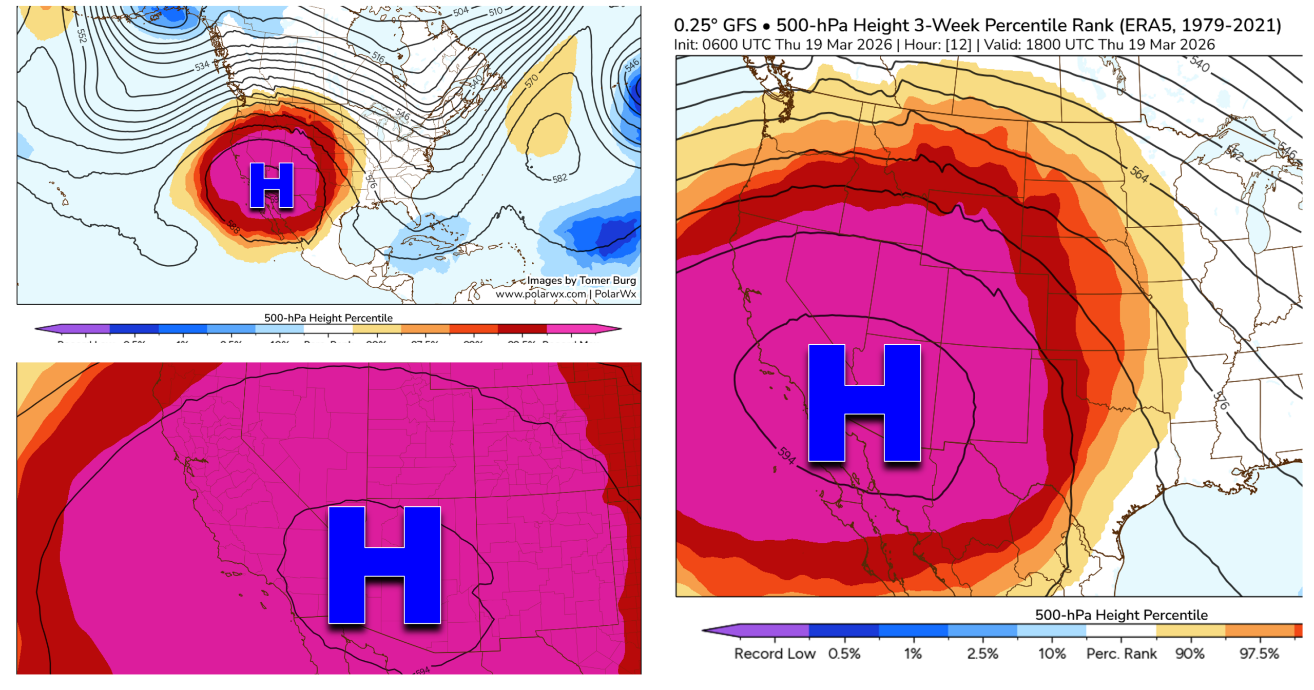
The ridge will remain fully concentric and remarkably intact through Friday before finally flattening and retreating southward into Mexico this weekend.
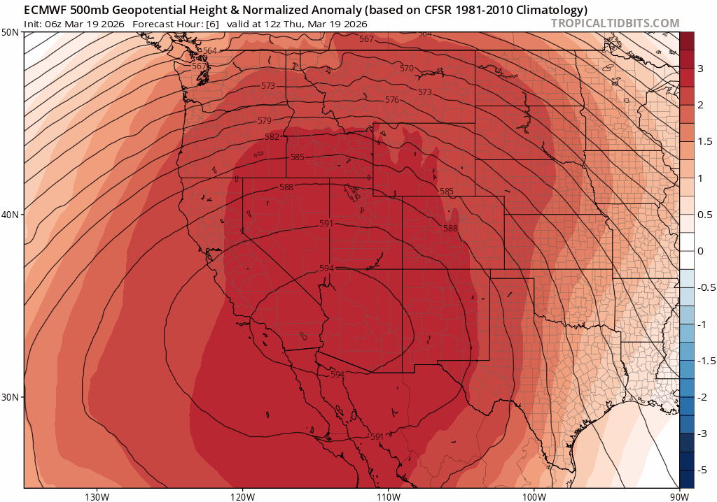
Euro 500mb height anomaly forecast for Thursday through Saturday night. The ridge flattens this weekend allowing a cold front to reach our area.
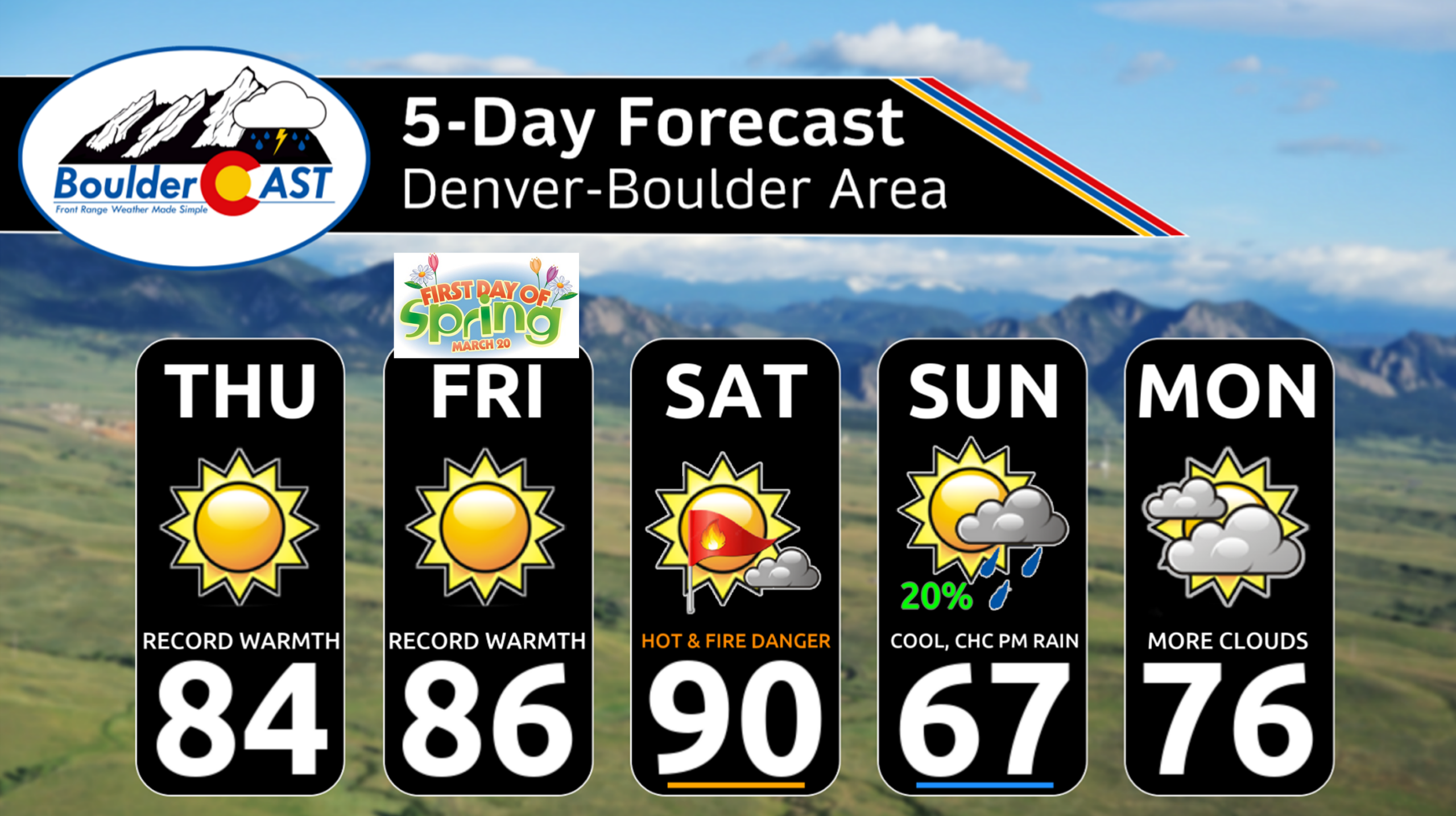
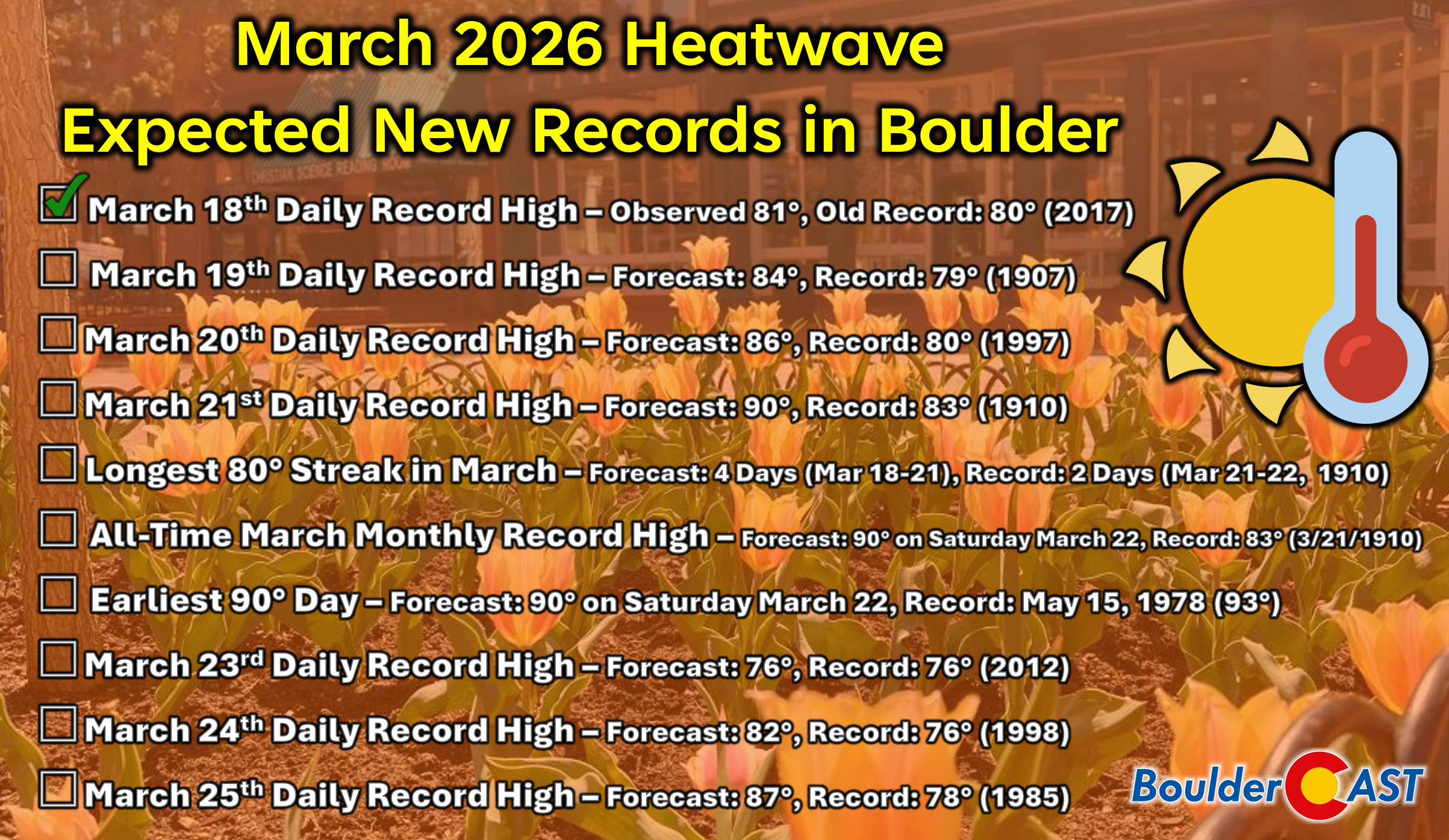
Temperatures will climb another couple of degrees today, with most Front Range locations landing between 83°F and 85°F. That means March 19th daily records will be obliterated across the board, and several cities—including Boulder and Denver—are poised to challenge or break their all‑time March monthly records. Friday brings a near‑repeat performance, though perhaps a degree or two warmer, keeping us squarely in record‑bashing territory.
Fire weather concerns remain focused along the Wyoming border today, where gusts up to 30 MPH have prompted another round of Red Flag Warnings in effect through 7PM. Closer to Boulder and Denver, winds will be breezy but generally capped at 15 to 20 MPH—below Red Flag criteria but still enough to breed minor concern.
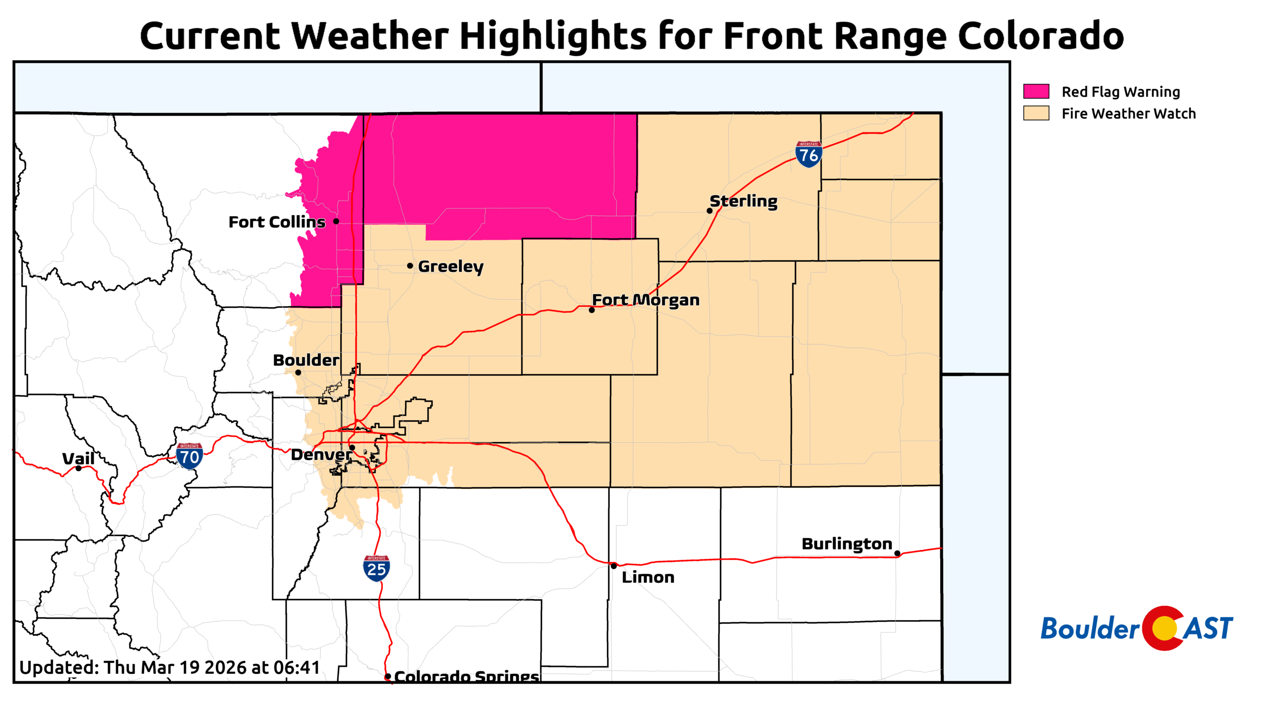
The Fire Weather Watch highlighted in the graphic above is not for Friday but instead is for Saturday, which remains the most concerning fire‑weather day of the entire heatwave—and also the hottest. As the ridge begins to weaken and shift, westerly flow will strengthen aloft, allowing more efficient mixing of downslope winds into the lower elevations. Humidity values will crash below 10%, temperatures will surge into the upper 80s to lower 90s, and afternoon wind gusts will commonly reach over 30 MPH. This combination is classic late‑spring fire weather, not something we typically see in March. It’s entirely plausible that Boulder Open Space may again close trails on Saturday, similar to last weekend’s precautionary shutdown. The wind speeds on Saturday are going to be far too low to trigger an Xcel Public Safety Power Shutdown, so do not worry about that.
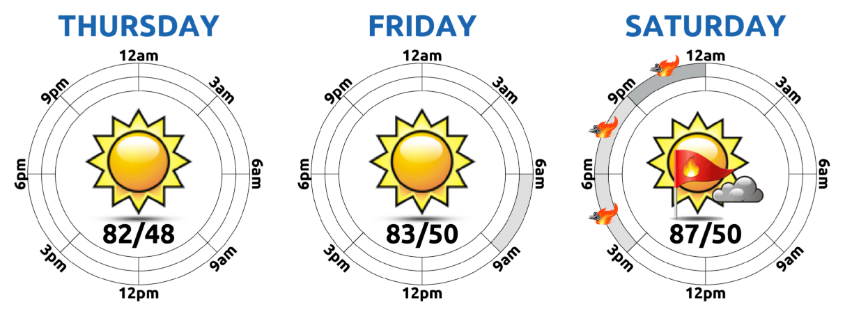
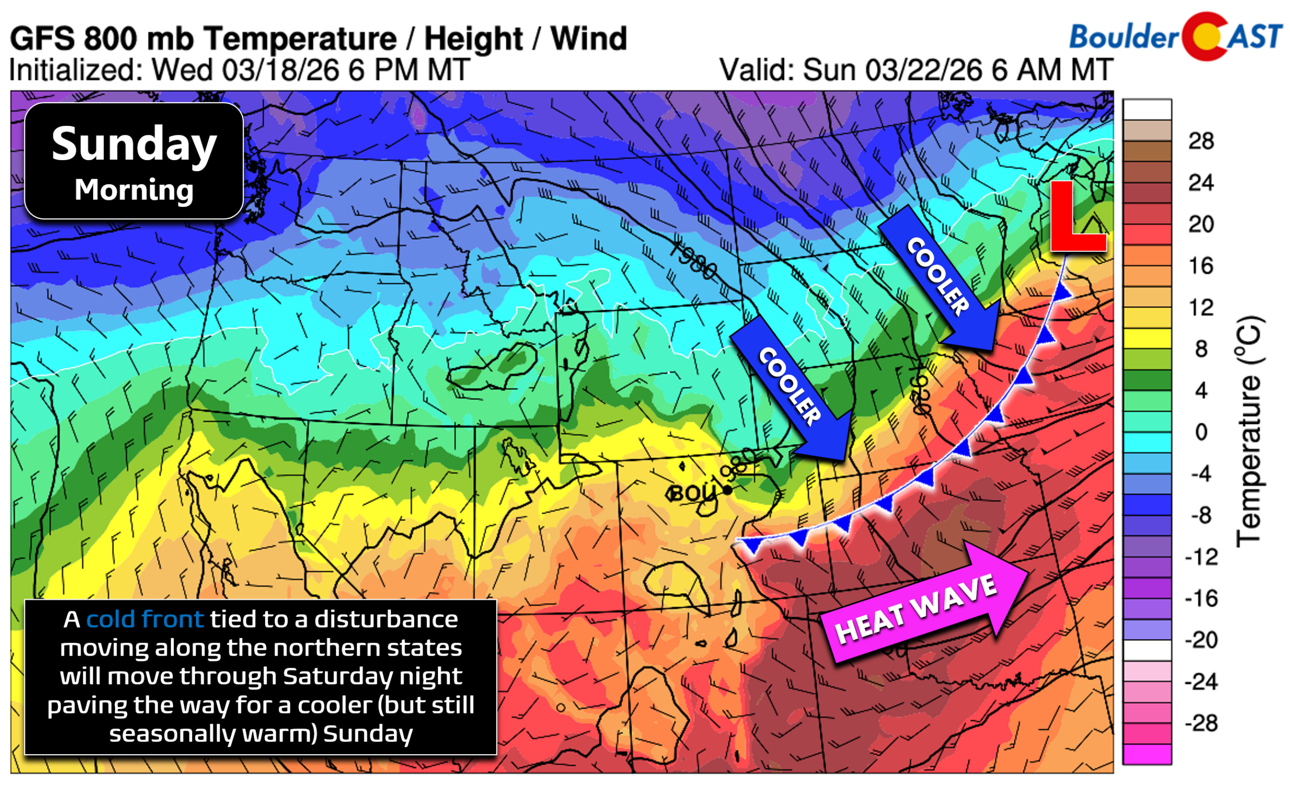
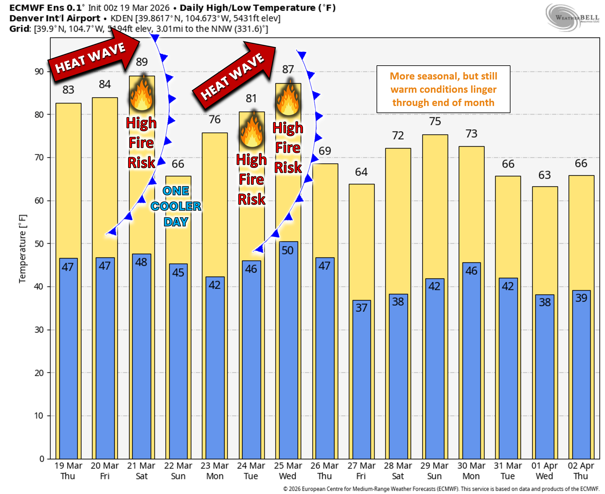
Our historic heatwave finally breaks Saturday night as a frontal boundary slides south into eastern Colorado. This front is not particularly cold by March standards, but it will be enough to knock temperatures back into the 60s on Sunday, ending our four‑day streak of 80°+ highs.
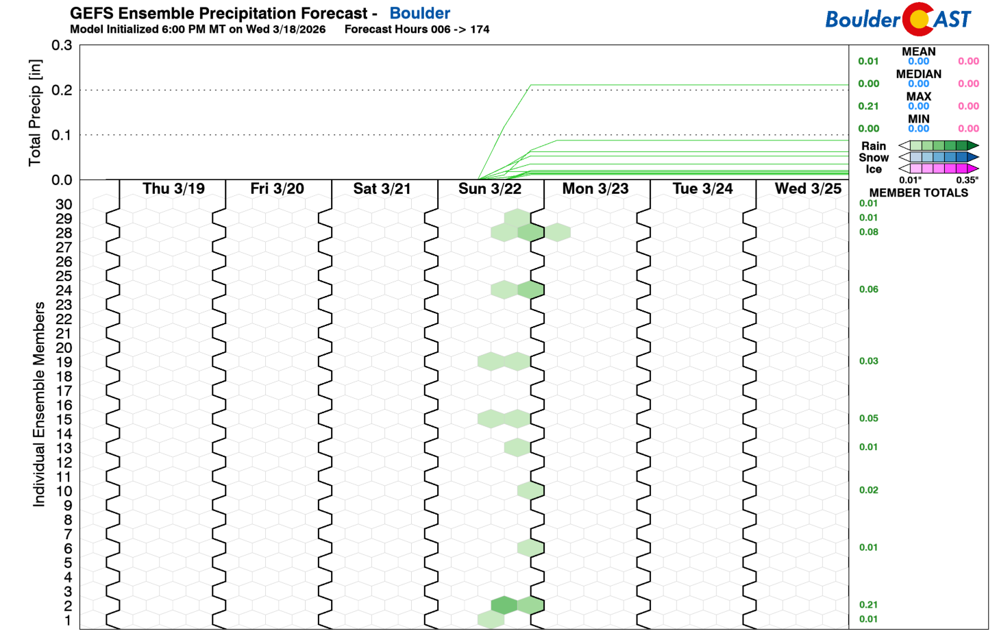
A few light rain showers may develop Sunday afternoon (around 20% chances), with spotty snow showers confined to the northern Mountains. Precipitation amounts will be very light—a few hundredths of an inch at best down low, up to a tenth in the High Country.
The five‑day forecast looks more like early June than mid‑March. The first day of spring on Friday will feel more like the first day of summer.
As for records: every day except Sunday carries a strong chance of setting new daily record highs.
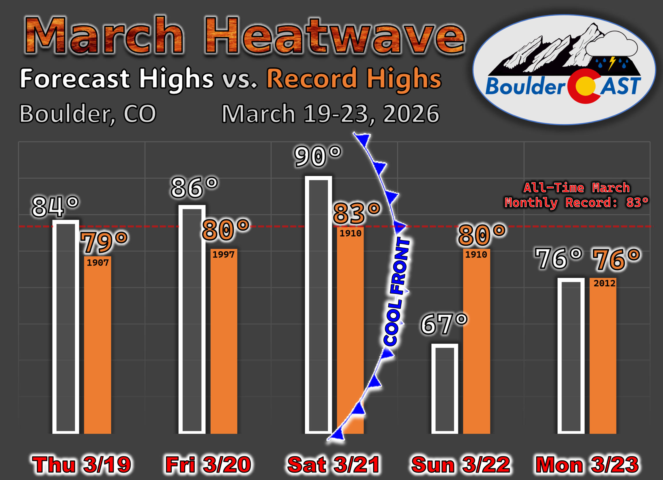
And whatever temperature we reach on Saturday—currently projected to be near 90°F—will become Boulder’s (and Denver’s) new all‑time March temperature record, shattering the previous mark from 1910 by roughly seven degrees. If we do reach the ridiculous 90-degree mark, that would be the earliest 90° day ever observed, breaking the prior record by an insane 8 weeks in Boulder (May 15th) and six weeks in Denver (April 30th).
Record heat will encompass the entirety of Colorado these next few days, and really all of the western United States which together will remain in firm grasp of the same historic ridge of high pressure. This is a truly exceptional event by every historical metric.
The weak front sliding through will knock temperatures down for a day in the Denver area, but it won’t fully dislodge the exceptionally hot airmass that built under this week’s intense ridge. That warmth will linger in the Desert Southwest and quickly rebound northward, pushing back into Colorado as early as Monday. Temperatures are expected to surge to historic levels again throughout the early and middle part of next week, putting daily record highs back in play for several days.
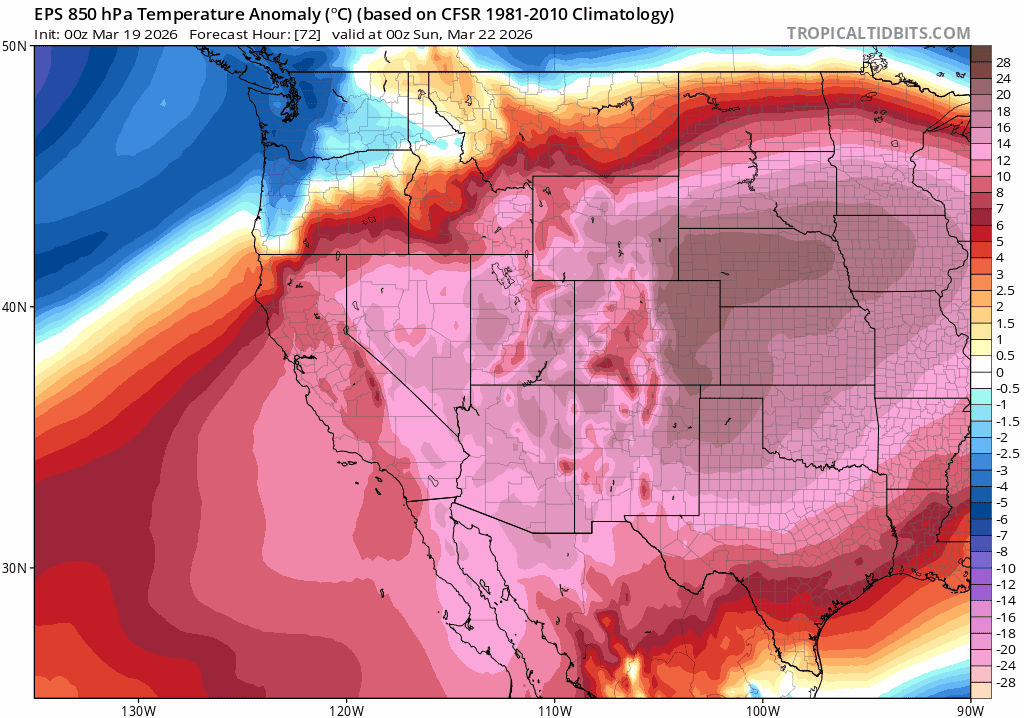
Euro ensemble 850mb temperature anomaly forecast animation for Saturday through next Wednesday. Note the cooldown in eastern Colorado but the quick resurgence of hot air behind it on Monday.
While the details are still coming into focus, the signal is strong: another round of 80°+ temperatures is likely by Monday or Tuesday, along with a renewed rise in fire danger to likely critical levels.
Bottom line
We’re in the midst of a truly historic March heatwave—one that’s already rewriting the record books and will continue doing so through Saturday as temperatures surge into the upper 80s and near 90°F. Fire danger will escalate sharply Saturday as well with bone‑dry humidity and strengthening downslope winds, bringing late‑spring fire behavior into a month that rarely sees anything like it. A weak cold front Saturday night will indeed knock us back into the 60s on Sunday, but the cooldown is only a brief one. The same anomalously hot airmass is set to reload early next week, pushing temperatures back into the 80s and threatening another multi‑day stretch of record highs and likely critical fire danger.
This heatwave isn’t just extreme for March—it’s unprecedented, persistent, and poised to return almost immediately after a short Sunday interruption.
Spread the word, share our crazy Colorado weather:
Go Premium, get all the perks.
Daily Forecast Updates
Get our daily forecast discussion every morning delivered to your inbox.
All Our Model Data
Access to all our Colorado-centric high-resolution weather model graphics. Seriously — every one!
Ski & Hiking Forecasts
6-day forecasts for all the Colorado ski resorts, plus more than 120 hiking trails, including every 14er.
Smoke Forecasts
Wildfire smoke concentration predictions up to 72 hours into the future.
Exclusive Content
Weekend outlooks every Thursday, bonus storm updates, historical data and much more!
No Advertisements
Enjoy ad-free viewing on the entire site.


You must be logged in to post a comment.