Category: Fire Weather (Page 1 of 38)

Boulder County Rolls Back Fire Restrictions as Extreme Drought Persists

Boulder County just rolled back its fire restrictions—right as we close the book on one of the hottest, driest, most fuel‑parching summers in recent history. The county says “improved conditions” justify easing the bans, yet rainfall has been almost impossible to come by within county limits, Extreme Drought now blankets 84% of the county, and fuel moisture is objectively worse today than when restrictions were last ramped up back in late June. It begs a very reasonable question: what exactly has improved? We break down the data behind the decision and examine why Boulder County’s fire environment remains primed as we step closer to autumn—historically one of our area’s most volatile fire seasons in recent years.

Continue reading

A Monsoon in Name Only: Inside One of Colorado’s Hottest, Driest Summers on Record

Summer 2026 is beginning to wrap-up, but before we close the books on one of Colorado’s most punishing warm‑season patterns in recent memory, we’re taking you through the full story — from the record‑warm, snow‑starved winter that set the stage, to the monsoon that never quite cohered leaving fuels critically dry statewide, to the heat dome that kept both day and night historically warm.

Read on as we break down why Boulder’s rainfall never materialized this summer, why Denver fared only marginally better, how nearly 250,000 acres burned statewide, and why half of Colorado is now in Extreme or Exceptional Drought. This summer has certainly been one for the record books, in more than one way.

Continue reading

This Week in Colorado Weather: August 24, 2026

A stubborn late‑summer pattern is locked in across the Front Range this week. While it won’t bring major shifts, it will deliver subtle day‑to‑day changes worth watching. A strong subtropical ridge keeps monsoonal moisture just high enough for daily storm chances, yet still too disorganized to produce reliable rainfall — a theme all summer. With shifting flow aloft, a mid‑week cold front and moisture bump, and a gradual drying trend late in the week, there’s plenty to unpack, from renewed severe potential to evolving flash‑flood risks and ongoing drought concerns. Read on as we break down the key ingredients driving this persistent — and likely still underperforming — monsoon pattern.

Continue reading

July 2026 Graphical Weather Review: In Some Respects, Boulder’s All-Time Hottest Month on Record

July 2026 along the Front Range was relentlessly hot, dry, and devoid of storms, dominated by stubborn upper‑level ridging that fueled long, punishing heatwaves and pushed Denver and Boulder into one of their hottest months on record. Occasional pulses of monsoonal moisture did break through, producing slow‑moving thunderstorms and localized flash flooding near vulnerable burn scars, while wildfire smoke from the West periodically dimmed skies and degraded air quality early in the month. With meaningful rainfall largely absent, Colorado’s severe drought deepened, cementing a July defined far more by heat and haze than by the usual rhythm of afternoon thunderstorms.

Here’s a graphical look at how July 2026 unfolded across Boulder, Denver, and the Front Range — and how it compared to climatology.
Continue reading

This Week in Colorado Weather: August 3, 2026

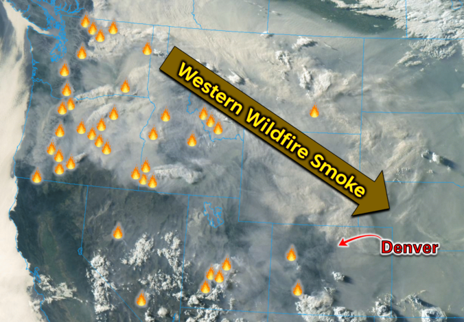
A blistering heat wave will end with one of the more dynamic forecast days we’ve seen all summer. From potentially record‑setting triple‑digit heat to a late‑day cold front, gusty virga showers, and a thick wall of wildfire smoke set to drop into the Front Range tonight, Monday packs an unusually busy mix of weather hazards and changes. We’ll walk you through the timing, the impacts, and the brief but welcome multi-day cooldown ahead — plus why the heat dome isn’t done with us yet. We also look ahead to when the monsoon could return.

Continue reading

Colorado Forecast Update: Triple Digits & Wildfire Smoke Loom as the Monsoon Temporarily Shuts Down

After a lively stretch of monsoon storms and even some flooding across the state, the atmosphere is shifting in a way that favors heat, haze, and a temporary shutdown of our storm pipeline for the Front Range. A stout Southwest heat dome is about to take center stage, triple‑digit temperatures are lining up for Boulder and Denver, and wildfire smoke is poised to make an unwelcome return. We break down the ridge, the records, the smoke, and the eventual cooldown.

Continue reading

This Week in Colorado Weather: July 27, 2026

Eastern Colorado just came off a truly blistering weekend, with Denver and Boulder both shattering daily records as temperatures surged past 100°F on back‑to‑back days. Now the pattern is shifting, at least temporarily. An unusually juiced monsoon plume will set the stage for more robust afternoon storms through mid‑week, including a legitimate threat for locally heavy rainfall and burn‑scar flooding. But the faucet will shut off quickly. A rapidly intensifying Southwest heat dome will retrograde into Arizona late‑week, cutting off monsoon flow, drying out northern Colorado, and potentially steering wildfire smoke from the Pacific Northwest into the state as winds shift. By the weekend, the Front Range will sit on the fringe of that expanding heat dome, meaning another round of hot, dry weather and potential triple-digit readings again. Read on for all the details.

Continue reading

« Older posts