Category: Fire Weather (Page 2 of 37)
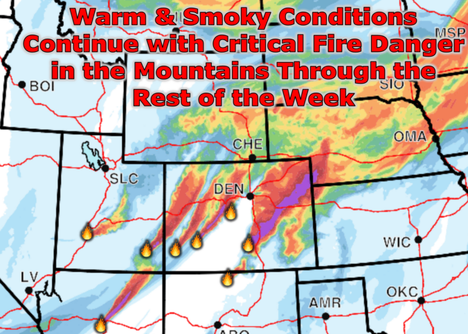
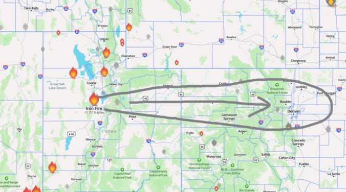
The last weekend of June didn’t just sizzle — it erupted. As a powerful early‑summer trough carved into the Great Basin, the Southwest lit up with new fires and thick smoke thanks to some of the most volatile atmospheric conditions we’ve seen this season. Colorado wasn’t spared, either: several fast‑growing fires ignited across the Western Slope and Mountains, sending plumes straight into the Front Range. And with a stubborn dipole pattern locking in place across the nation, the week ahead promises more wind, more dryness, and more smoke — plus a few twists in the forecast you’ll want to keep an eye on. Let’s break down what’s driving this outbreak, what it means for the Boulder–Denver corridor, and when relief may finally arrive.
The atmosphere is gearing up for one of those classic late‑June stretches where Colorado tries to run every weather storyline at once. Several days of unusually strong flow aloft, deepening upslope moisture, and a parade of shortwaves are about to collide over the Front Range. The result will be day after day of severe thunderstorms. Add in waves of incoming wildfire smoke and a potentially high‑end fire danger setup by the weekend, and there’s plenty to unpack in this week’s forecast. Let’s take a closer look.
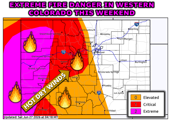
A western heat dome is gearing up to push the Front Range toward its hottest stretch of the season so far, with downslope winds and fire‑weather concerns building right alongside it. A weak front will try to break the heat later in the week, but largely fail as temperatures rebound into the 90s quickly by Friday and the weekend. As our spring wet season has now come to an end, storm chances remain woefully low throughout the extended leading to further drought intensification statewide.

Warmth, wind, and a few atmospheric curveballs are lining up for the Front Range this week — and it all starts with a sharp swing from severe storms to hot fire danger in less than 24 hours. From Monday’s hail‑ready instability to mid‑week blow‑dryer conditions and a potential cool‑down lurking on the weekend horizon, this week’s forecast has a little bit of everything. Read on as we detail what to watch as this surprisingly active June pattern unfolds across Colorado.

Live View of Boulder

Current Conditions

Live Radar

Latest Smoke Forecast

Recent Premium Posts

BoulderCAST Daily – Sat 07/11/26 | Here comes the heat!
🥵 Heat start today: Upper 90s start today and continue well into next …
BoulderCAST Daily – Fri 07/10/26 | The heat builds into the weekend
⛈️ Storms around today: A weak impulse of energy favors some isolated storms …
BoulderCAST Daily – Wed 07/08/26 | The Front Range Has Broken Out of the Haze — Storms Fire After Noon
🌬️ Smoke has (mostly) cleared out: Westerly flow pushed the thick plume south/east, …
3-Day Forecast

Trending Content

© 2026 Front Range Weather, LLC