
Warmth, wind, and a few atmospheric curveballs are lining up for the Front Range this week — and it all starts with a sharp swing from severe storms to hot fire danger in less than 24 hours. From Monday’s hail‑ready instability to mid‑week blow‑dryer conditions and a potential cool‑down lurking on the weekend horizon, this week’s forecast has a little bit of everything. Read on as we detail what to watch as this surprisingly active June pattern unfolds across Colorado.
This week’s highlights include:
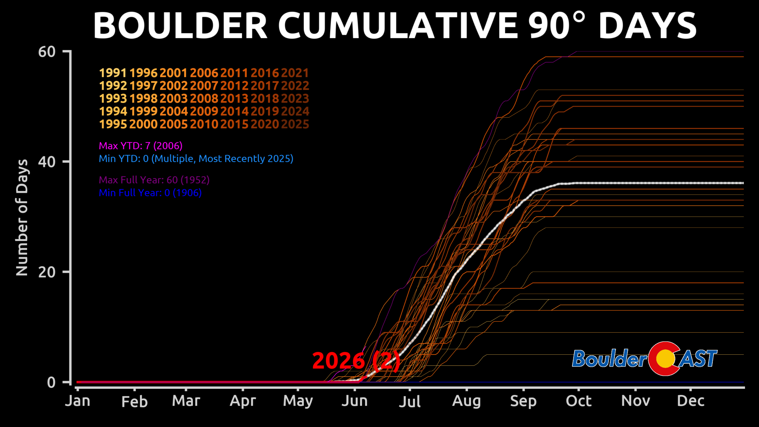
🥵 First 90s of 2026 in the Book: Boulder finally cracked the 90° mark this past weekend, hitting 92° Saturday and 93° Sunday, ending a streak of near‑misses in the upper 80s.
🌩️ Severe storms Monday: A weak early‑morning cold front plus upslope moisture sets the stage for scattered severe thunderstorms across northeast Colorado.
⚡ Instability + shear: If the cap breaks, storms will tap into 1000–2000 J/kg CAPE and 45–55 knots of shear, supporting supercells with very large hail and a small tornado risk.
⏱️ Timing for Boulder–Denver: Storms fire early afternoon near the Foothills, with the 1–6 PM window carrying the highest severe threat locally before all activity shifts east.
🔥 Fire danger spikes Tue–Wed: Hot, dry, windy conditions surge back with gusts 25–35 MPH, humidity near 10%, and highs in the low to mid‑90s, supporting elevated to near‑critical fire danger. Red Flag Warnings are possible for some of the area.
🌡️ Record temperature watch: Tuesday’s heat will approach June 9th record highs — which are 96° in Boulder and 95° in Denver — though current guidance keeps us just shy.
📉 Brief cooldown late week: A weak front Wednesday night brings temps back to the upper 70s to low 80s, with very dry air keeping storm chances at bay.
🌦️ Weekend pattern shift: Moisture returns from the south, bringing isolated to scattered storms and a potential cooler stretch in the 70s heading into early next week.
DISCLAIMER: This weekly outlook forecast is created Monday morning and covers the entire upcoming week. Accuracy will decrease as the week progresses as this post is NOT updated. To receive daily updated forecasts from our team, among many other perks, subscribe to BoulderCAST Premium.

Go Premium, get all the perks.
Daily Forecast Updates
Get our daily forecast discussion every morning delivered to your inbox.
All Our Model Data
Access to all our Colorado-centric high-resolution weather model graphics. Seriously — every one!
Ski & Hiking Forecasts
6-day forecasts for all the Colorado ski resorts, plus more than 120 hiking trails, including every 14er.
Smoke Forecasts
Wildfire smoke concentration predictions up to 72 hours into the future.
Exclusive Content
Weekend outlooks every Thursday, bonus storm updates, historical data and much more!
No Advertisements
Enjoy ad-free viewing on the entire site.
✅ First 90° day(s) of the year
As warm as this spring has felt, it may have seemed like Boulder had already cracked 90° several times — but that wasn’t the case. We flirted with it repeatedly, hitting 88–89° four different times in 2026, yet never sealing the deal. Denver followed a nearly identical trajectory. That changed over the weekend as the atmosphere finally tipped into true summer mode. Boulder officially logged 92° on Saturday, marking the city’s first 90° day of the year.
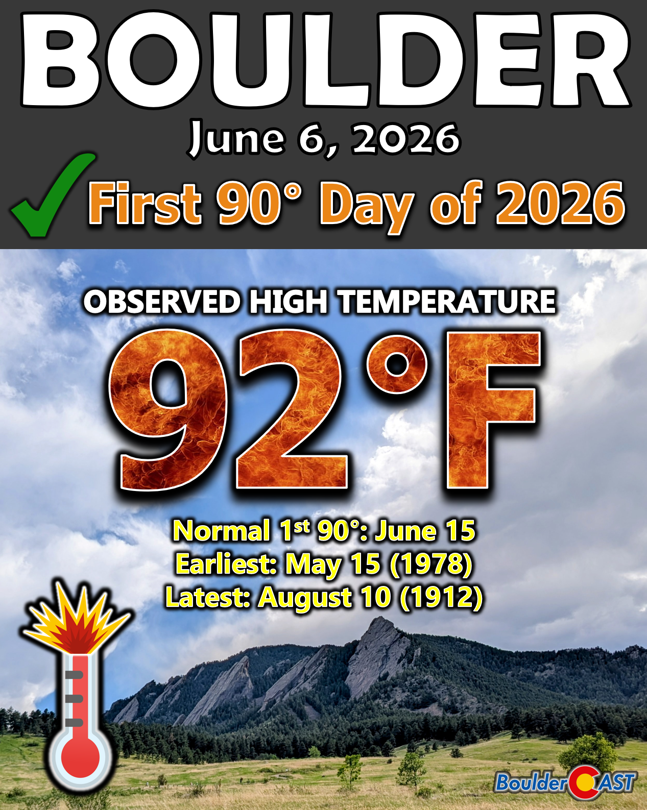
Sunday followed with 93°, bringing the year‑to‑date 90° tally to two. With more heat queued up this week, that number will climb…
Severe Storm Risk on Monday
A weak cold front slipped south through the region during the early‑morning hours Monday, setting the stage for scattered severe thunderstorms across northeast Colorado. Behind the front, temperatures will cool, but easterly upslope flow will tap us into Gulf moisture and boost low‑level dew points — a key ingredient for storm development.

The big question is whether we can break the cap. Cooler post‑frontal air and the current deck of morning stratus clouds make this somewhat uncertain.

View of the potentially severe-busting cloud deck over Boulder Monday morning
However, if storms do initiate, they’ll have access to 1000 to 2000 J/kg of CAPE, per short‑range guidance — plenty for robust updrafts.

Wind shear won’t be lacking either. Model soundings show 45–55 knots of deep‑layer shear across the Front Range Monday afternoon, more than enough to support organized supercells.

Put it all together — moisture, instability, and shear — and Monday carries a very real severe weather threat. Hazards include:
- Very large hail (up to tennis balls in Denver area, softballs further east))
- One or two tornadoes (perhaps even strong ones)
- Damaging winds (mainly well east of Denver during the evening)
The NOAA Storm Prediction Center places most of northeast Colorado under a Slight Risk (Level 2/5), with Boulder, the western suburbs, and the Foothills in a Marginal Risk (Level 1/5).
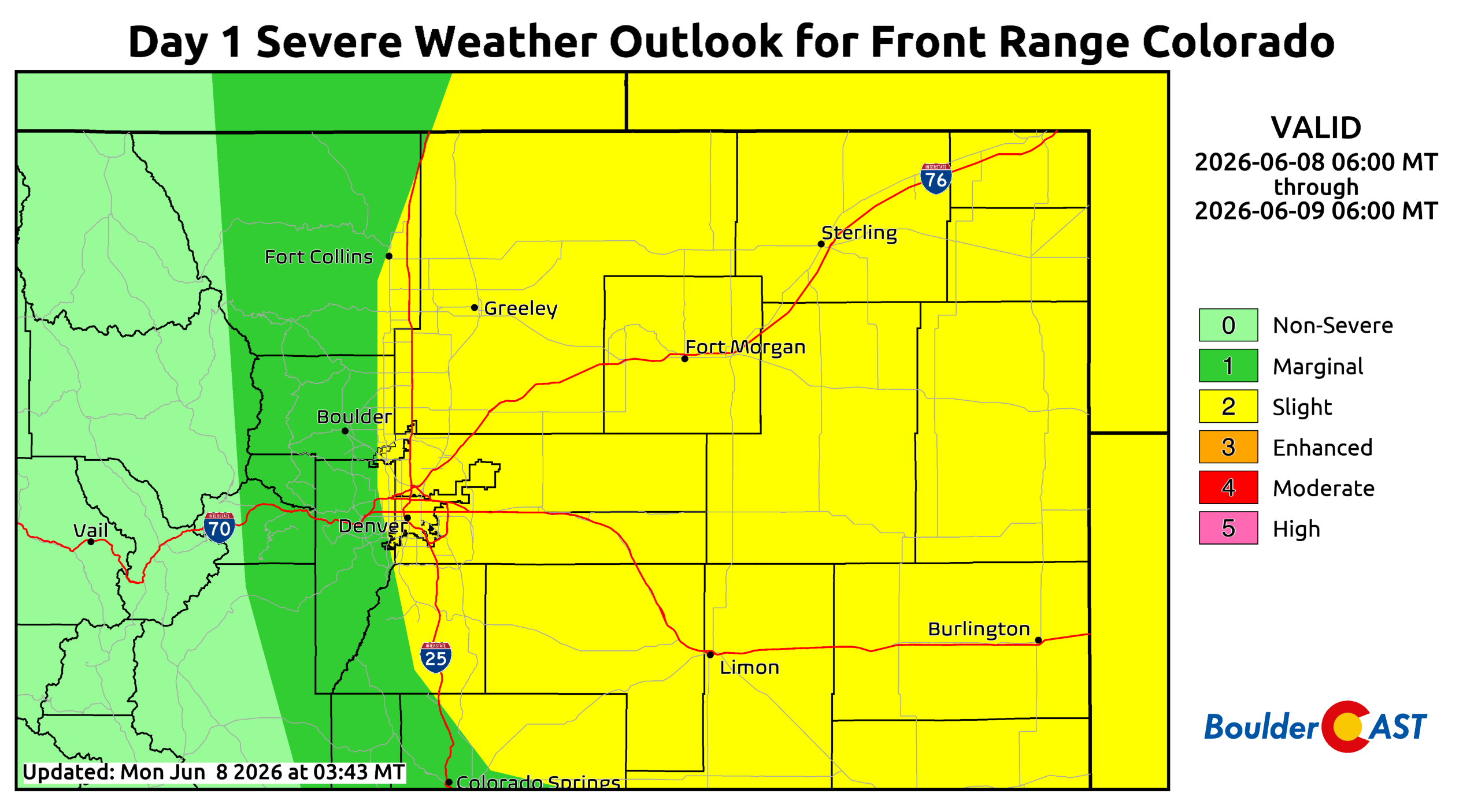
Storms should initiate near the higher terrain early in the afternoon, then intensify rapidly as they move east of I‑25. Supercells with very large hail will dominate the early threat window, transitioning to a wind‑driven event toward Kansas and Nebraska later in the evening.
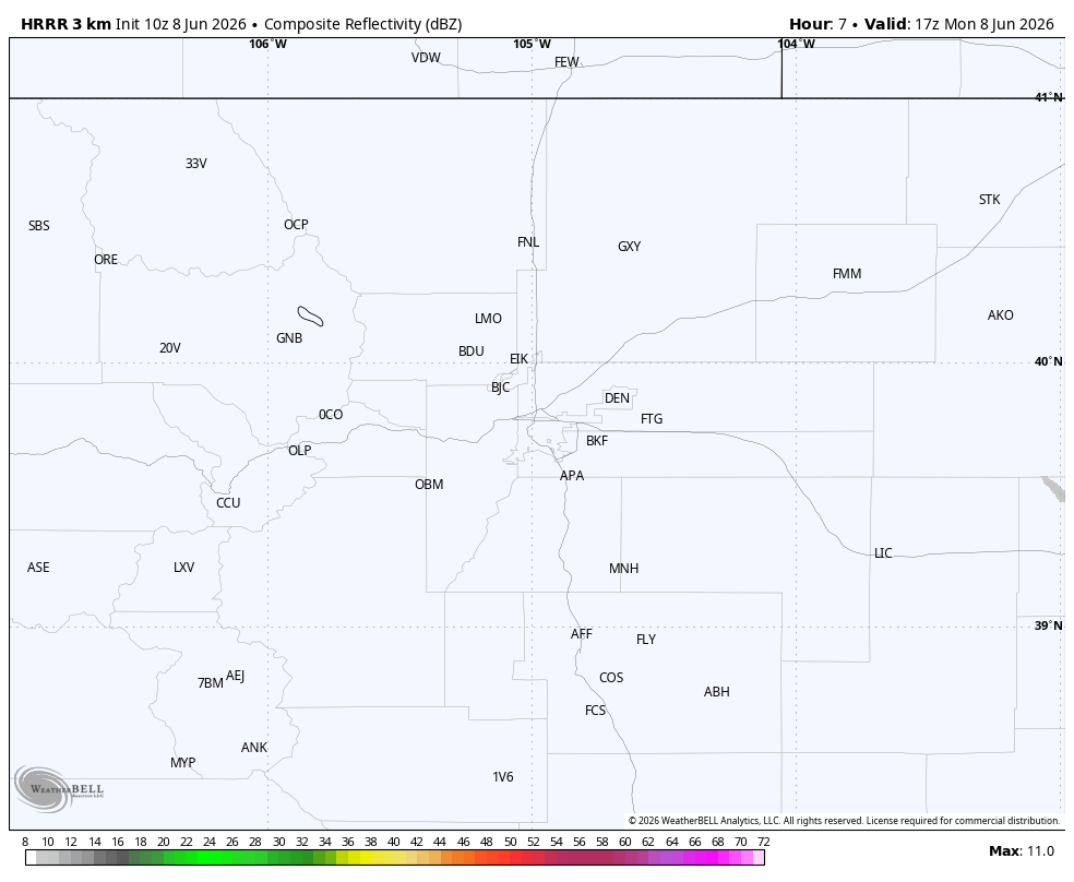
HRRR simulated radar for Monday showing the explosion of severe storms over NE Colorado
For Boulder–Denver, the primary severe window runs 1–6 PM with hail up to tennis ball-sized (2.5″). After that, activity shifts east and conditions will quiet down. Highs land in the upper 70s to middle 80s. Keep an eye on the sky Monday afternoon — the big hail risk is higher than usual around here!

Hot, Dry, and Windy Tuesday & Wednesday
The pattern flips sharply Tuesday. Monday’s brief cooldown vanishes as hot, dry air surges back into the Front Range. Expect:
- 25 to 35 MPH gusts
- Low to mid‑90s for highs
- Humidity near or below 10%
This “blow‑dryer” setup will support elevated to near‑critical fire danger. Red Flag Warnings are possible, though some areas may be excluded thanks to May’s beneficial moisture keeping fuels less receptive to ignition.

Fire weather outlook for Tuesday
Wednesday brings a near‑repeat performance. A weak cool front Tuesday night won’t do much; highs still reach the upper 80s to near 90°, with humidity and winds similar to Tuesday. Another day of elevated to near‑critical fire danger is likely.

Record highs — 96° in Boulder and 95° in Denver for June 9 — will be within reach Tuesday, though current guidance suggests we will fall a bit short.
Quieter Late Week
Another weak cold front will move in Wednesday night or early Thursday, tied to a system in southern Canada. Timing varies widely among models, but the outcome is similar: cooler temperatures in the upper 70s to lower 80s and a temporary pause in fire danger.

Very dry air will linger over northern Colorado through early Saturday, so rain chances for us remain nearly non-existent from mid to late-week.
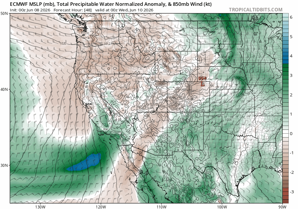
Euro precipitable water forecast animation for mid to late week showing the persistent dry air over the Front Range that will keep storm chances very low to near zero.
By Friday, highs rebound to near 90° again. Winds may increase, and with continued dry air, another round of near‑critical fire danger is possible.
A Cooler, Wetter Weekend?
Storm chances will tick upward this weekend as deeper moisture returns from the south. Nothing looks particularly organized yet, but isolated to widely scattered storms should reappear by late Saturday and continue into early next week.

Extended ensemble guidance hints at a cooler stretch developing Sunday into early next week, with highs dropping back into the 70s — a welcome break after the early‑June heat of late.

The Climate Prediction Center supports this idea, showing increased odds for both cooler and wetter conditions heading into early next week for the Front Range.

Bottom Line
In all, this week will deliver the full spectrum of early‑June volatility: a burst of severe storms to start, a fast‑moving return to heat and fire danger midweek, and a subtle but promising shift toward cooler, wetter conditions by the weekend. The pattern isn’t locked in yet, but the signals are there: moisture creeping back in, temperatures trending down, and at least a brief break from the blow‑dryer regime. Be sure to stay weather‑aware through the first half of the week given the severe storm and fire risk, and keep an eye on how the weekend setup evolves. Several days in the 70s might actually be waiting on the other side for us!
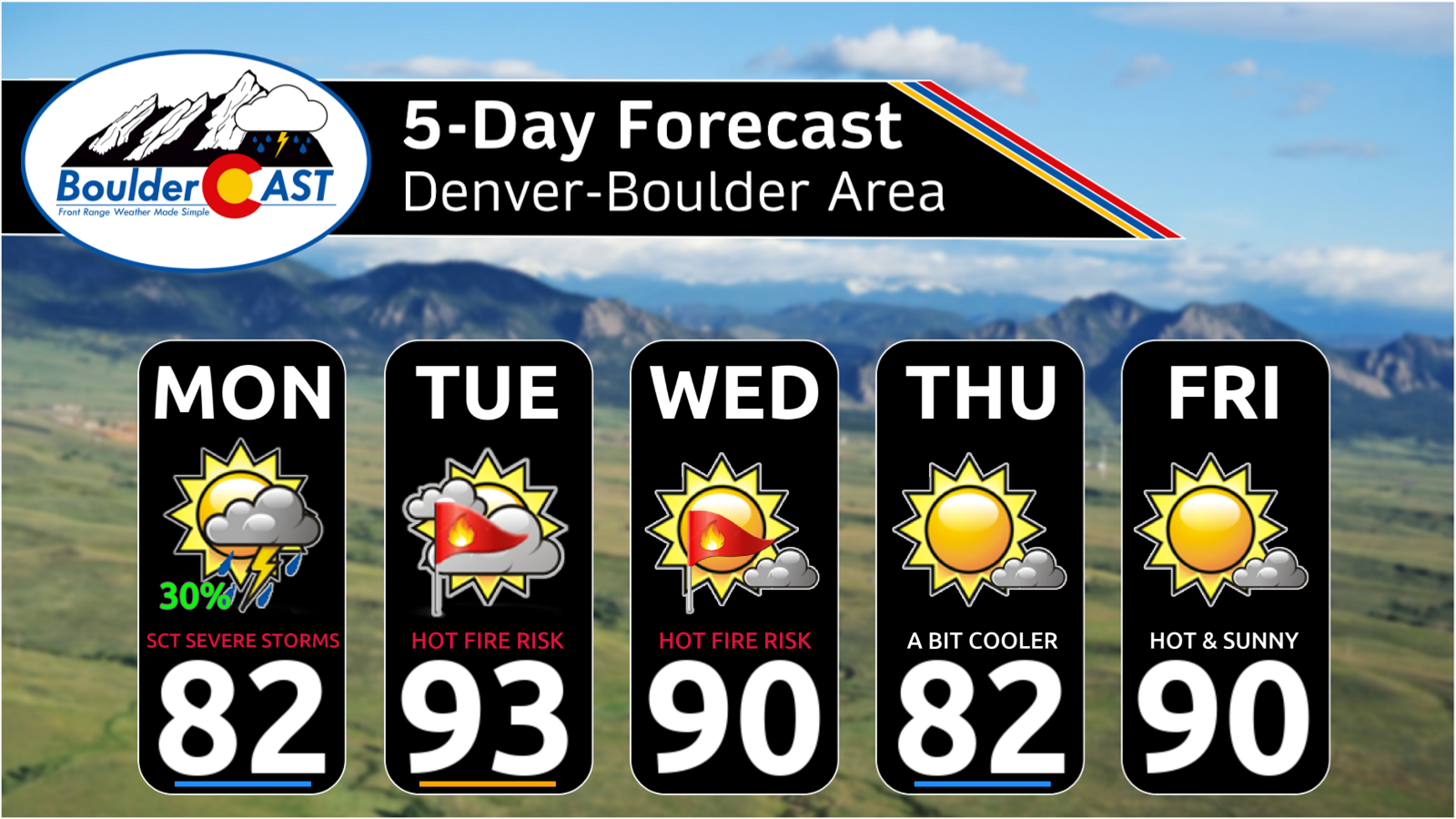
Forecast Specifics:
Monday: Scattered strong to severe thunderstorms during the afternoon hours with large hail the primary concern (up to 2.5″ diameter or tennis ball-sized). Highs in the upper 70s to lower 80s on the Plains, with upper 60s in the Foothills.
Tuesday & Wednesday: Partly cloudy, hot and gusty with near-critical fire danger developing each day. Winds will gust 25 to 35 MPH with humidities near or below 10%. Highs across the lower elevations will be in the low to middle 90s with upper 70s in the Foothills. Red Flag Warnings may be issued for some of the area both days.
Thursday: Mostly sunny and cooler behind an overnight or morning cold front. Highs near the lower 80s for the Plains with lower 70s in the Foothills.
Friday: Heating back up again with a potential return to near-critical fire danger. Highs will land near 90° on the Plains with upper 70s in the Foothills. Gusty winds will be around.
DISCLAIMER: This weekly outlook forecast is created Monday morning and covers the entire upcoming week. Accuracy will decrease as the week progresses as this post is NOT updated. To receive daily updated forecasts from our team, among many other perks, subscribe to BoulderCAST Premium.
Go Premium, get all the perks.
Daily Forecast Updates
Get our daily forecast discussion every morning delivered to your inbox.
All Our Model Data
Access to all our Colorado-centric high-resolution weather model graphics. Seriously — every one!
Ski & Hiking Forecasts
6-day forecasts for all the Colorado ski resorts, plus more than 120 hiking trails, including every 14er.
Smoke Forecasts
Wildfire smoke concentration predictions up to 72 hours into the future.
Exclusive Content
Weekend outlooks every Thursday, bonus storm updates, historical data and much more!
No Advertisements
Enjoy ad-free viewing on the entire site.
Enjoy our content? Give it a share!


You must be logged in to post a comment.