Let’s take a look at how we ended up in a severe drought so quickly and where things might go in the winter months ahead.
NOTE: For the climatology discussions in this post, we are referencing meteorological autumn which by definition runs from September 1st to November 30th.
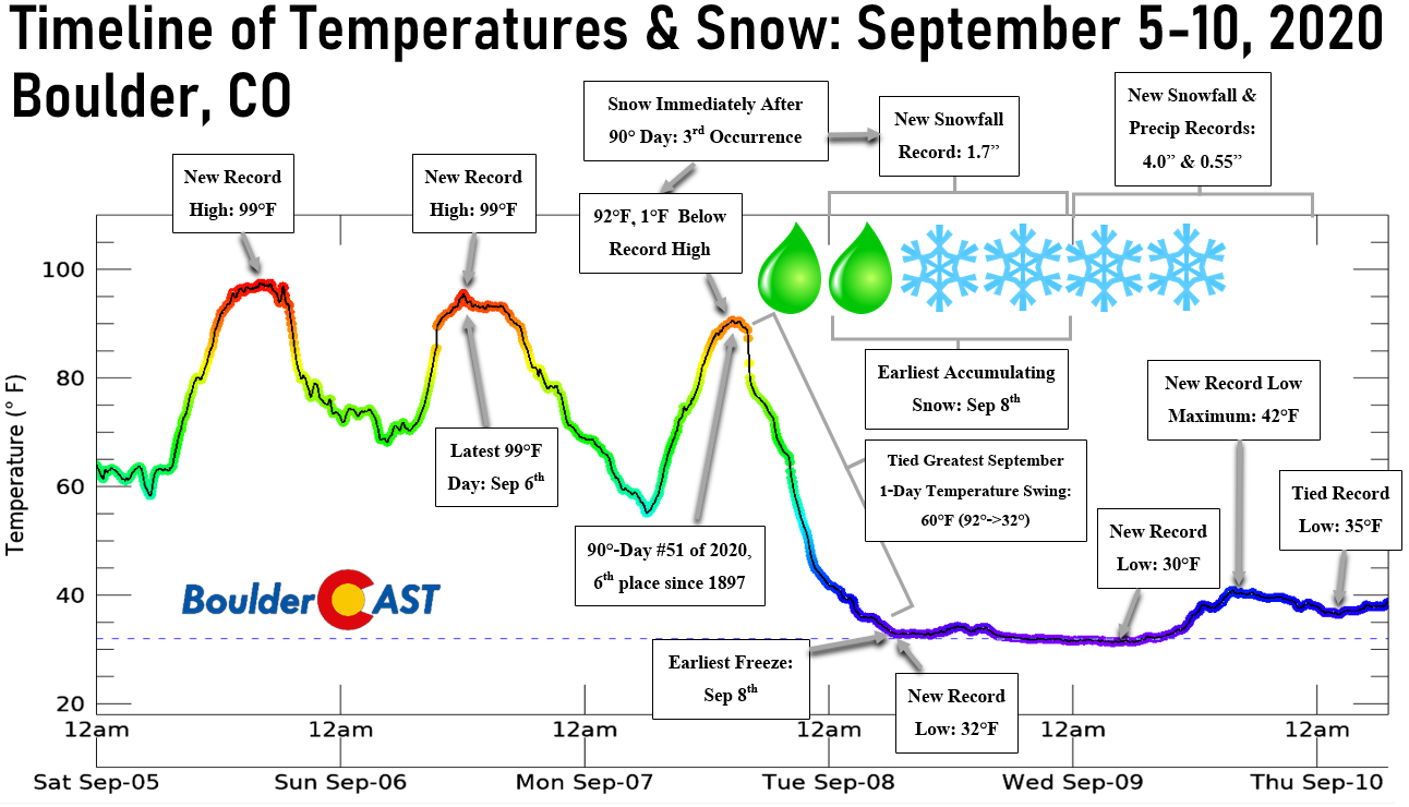
More often than not, we barely get time to enjoy everything that autumn has to offer because it rarely lasts more than a few hours, or days if we’re lucky. The gap between the searing summer heat is often woefully short here in the Denver area. There’s no clearer example of this than the crazy shift from summer to winter that occurred in early September of last year when it went from 100-degrees to accumulating snowfall in the blink of an eye! While this change happened a few weeks sooner than normal producing Boulder’s earliest snowfall on record, the manner in which it went down is all too familiar. Front Range Colorado has one of the most varied climates and weather patterns in the country and arguably the world due to our close proximity to a massive mountain range and interior continental positioning. As many of your know, the transitional seasons here are a wild ride like no other!
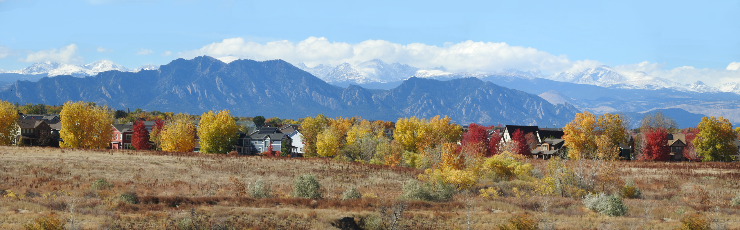
This autumn started out as a breath of fresh air, but it soon became clear something was just not right, even by Front Range standards. No snow was in the forecast, not even any cold air and certainly not any moisture. For once, we got to enjoy the beautiful fall colors, which actually is not that common here due to how soon the first snow and Arctic airmasses tend to arrive and bring down the leaves before the colorful show even starts.
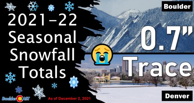
Fast forward to now. At the beginning of December, Boulder has reported less than 1″ of total snowfall for the season.
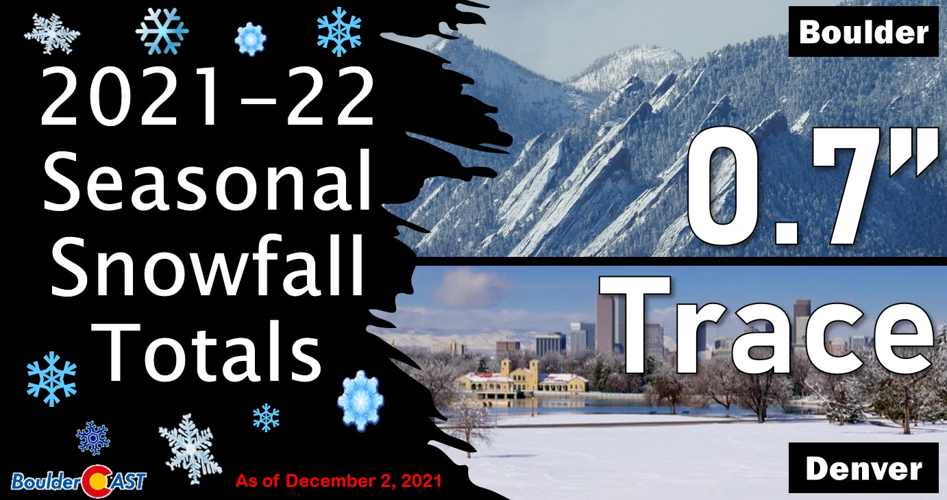
It took forever, but Boulder officially notched its first snow on November 21st which tied for the latest ever first snow. Better late than never, we say. Even worse, Denver is still waiting in purgatory for its first snow entirely. Let this sink in — this was the first autumn in recorded history completely devoid of measurable snow in Denver!
Boulder Latest First Snows
- #1: November 21 (2021 & 2016)
- #3: November 15 (2005, 1988, 1987, 1962)
- #7: November 14 (1964)
- #8: November 11 (2015)
- #9: November 9 (2010)
- #10: November 8 (1983 & 1977)
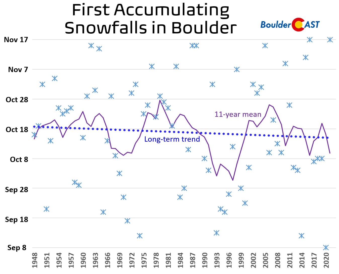
Not surprisingly, Fall 2021 concluded as Boulder’s least snowy as well when considering the more reliable snowfall data which began in 1948.
Boulder’s Least Snowy Autumns (1948 to Present)
- #1: 0.7″ (2021)
- #2: 1.5″ (1982 & 2008)
- #4: 1.9″ (2005)
- #5: 2.0″ (2010)
- #6: 2.5″ (1978)
It’s not just a dearth of snow this autumn has put forth. It’s a complete lack of moisture resulting from extended periods of unfavorable weather patterns. Yes, this year was Boulder’s driest fall on record as well with an embarrassing total of rain and melted snow amounting to just 0.78″. For reference, Boulder’s average fall-time precipitation is 4.87″. For Denver, this was the third driest fall with only 0.43″ recorded at the airport.
Boulder’s Driest Autumns
- #1: 0.78″ (2021 & 1944)
- #3: 0.81″ (1901)
- #4: 1.00″ (1943)
- #5: 1.16″ (1977)
- #6: 1.18″ (1917)
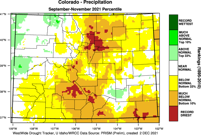
With the exception of far northwestern Colorado, most of the state was exceptionally dry this fall, but none so anomalously as the Boulder-Denver area.
After an extremely snowy spring headlined by the monster March blizzard, things have slowly taken a dry turn for much of Colorado. There was almost no monsoon season for the Denver Metro area. Thankfully, the rainy season was closer to normal in the Mountains which helped stave off a devastating fire season in the High Country. We had our fair share of smoke this summer, but fortunately most of it was from massive out-of-state wildfires.
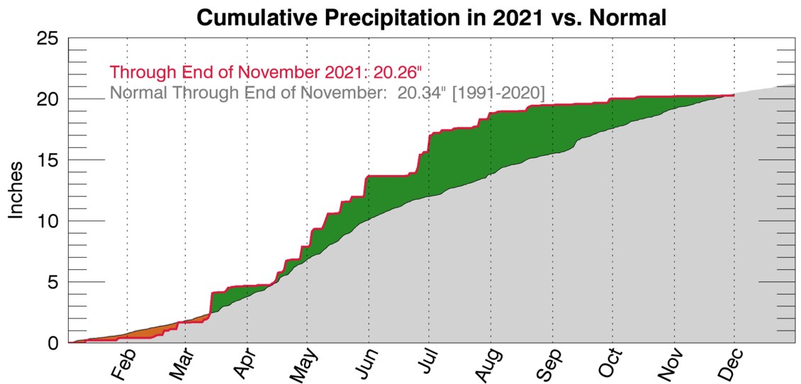
A combination of the extra dry fall and a meager monsoon showing immediately prior has left us in a tough place heading into winter. The last four months have been the driest such stretch on record for both Boulder and Denver.
It’s hard to believe, but at one point in late July, Boulder was sitting pretty with a roughly 5″ precipitation surplus for the calendar year. The hydrological outlook was actually good for once. It’s taken a solid four months, but we’ve slowly but surely chipped away at the surplus entirely and are now at a slight deficit for the year.
During the autumn, drought has expanded from covering 36% of the state up to 95% as of November 30th. Drought has improved slightly in the northwest corner of the Centennial State, but everywhere else it has gotten drastically worse — again with the Denver Metro area leading the charge.
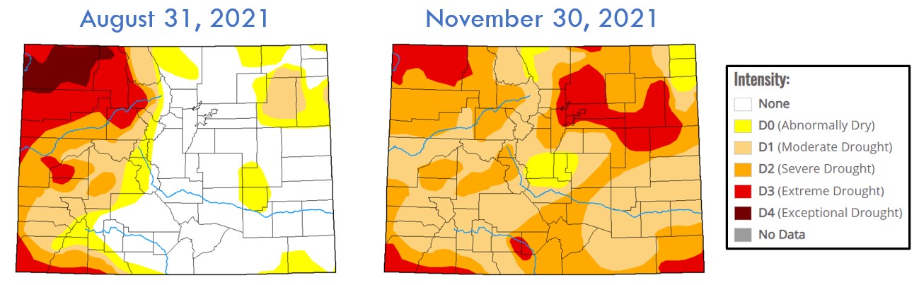
Change in drought intensity throughout the fall for Colorado | US Drought Monitor
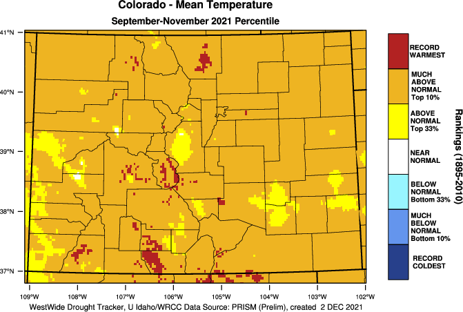
As is so often the case, when it is drier than normal it will also be warmer than normal. This autumn was overall Boulder’s 6th warmest since records began in the 1890’s. September and November where particularly toasty, while October was somewhat closer to normal. Similarly, this fall was Denver’s second warmest.
Boulder’s Warmest Autumns
- #1: 57.8°F (1953)
- #2: 57.5°F (1963)
- #3: 57.1°F (2016)
- #4: 56.9°F (1949)
- #5: 56.4°F (1956)
- #6: 56.3°F (2021)
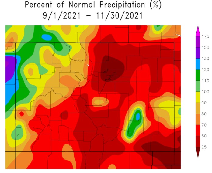
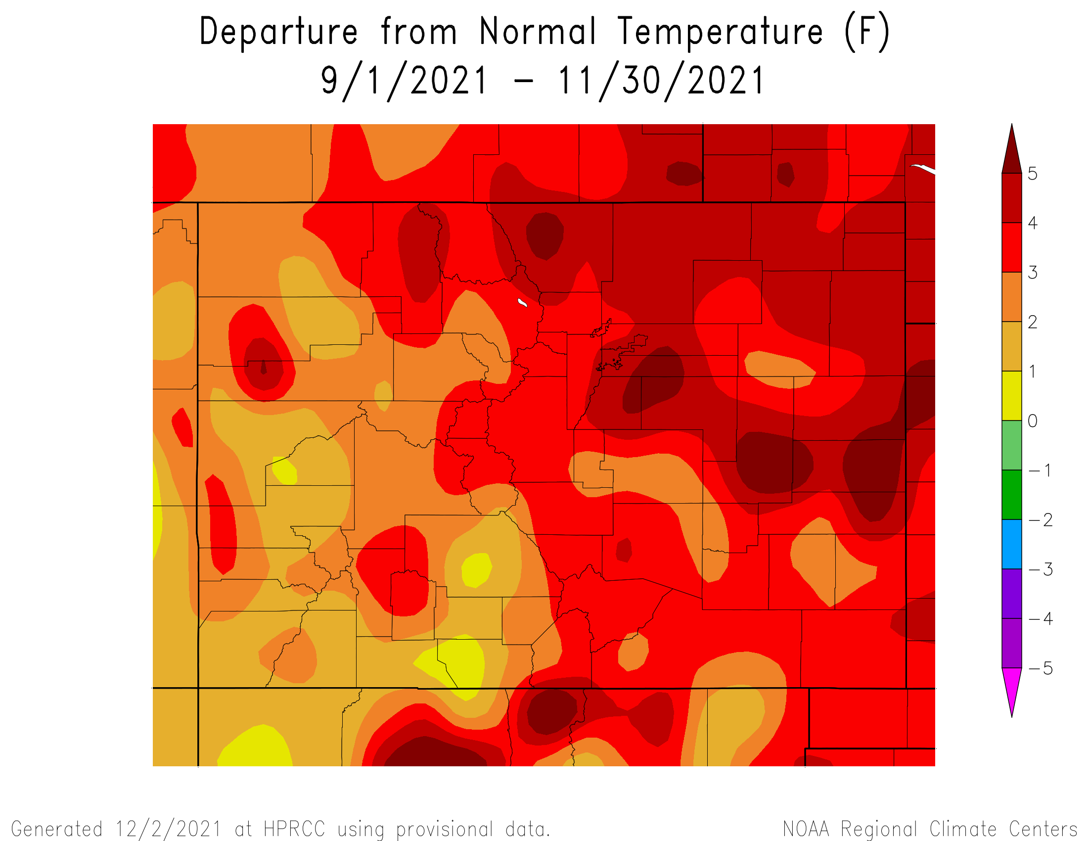
The entire state saw above average fall temperatures overall, in some cases by more than 5°F. That may not sound like a lot, but that’s five degrees over the entire season which is quite remarkable.
The locations in red below had their warmest autumn on record.
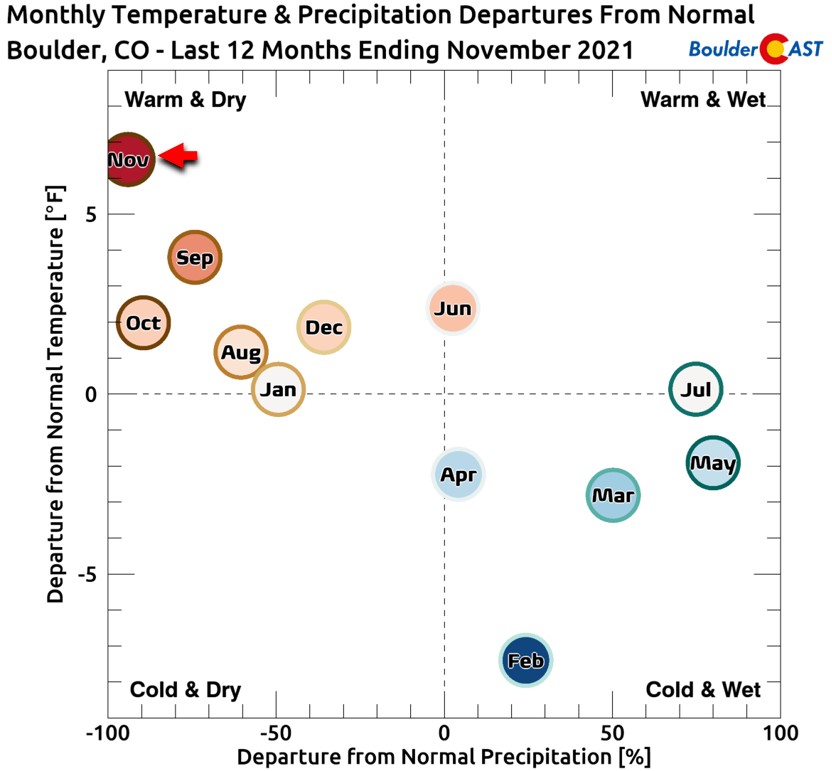
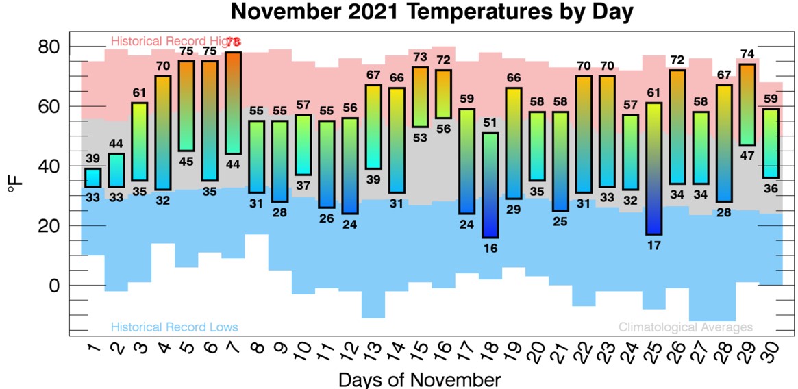
November was the month where everything culminated and ultimately solidified the fate of Autumn 2021; November was the 7th driest and 3rd warmest for Boulder.
Boulder’s Driest Novembers
- #1: 0.00″ (1913)
- #2: Trace (1899, 1901 & 1949)
- #5: 0.01″ (1984)
- #6: 0.05″ (1939)
- #7: 0.07″ (2021)
- #8: 0.08″ (1904)
Boulder’s Warmest Novembers
- #1: 53.1°F (1949)
- #2: 48.4°F (1904)
- #3: 48.0°F (2021, 1999 & 1901)
- #6: 47.9°F (1917)
The temperatures reached 70 degrees on 10 different occasions during the month, one shy of the record set back in 1939.
Boulder Novembers With Greatest Number of 70+ Degree Days
- #1: 11 days (1939)
- #2: 10 days (2021, 2017 & 1999)
- #5: 9 days (2016 & 1949)
- #7: 8 days (1953 & 1931)
Of course, we had a feeling this is how autumn would play out across the area. Maybe not to this extreme end of the spectrum, but our autumn outlook did call for warmer and drier than normal weather as La Niña dubiously reformed in the tropical Pacific Ocean. This season in particular tends to be warm and dry under La Niña patterns. The good news is that the warm/dry signal goes away during the coldest winter months ahead (and actually reverses by the time we get to February).
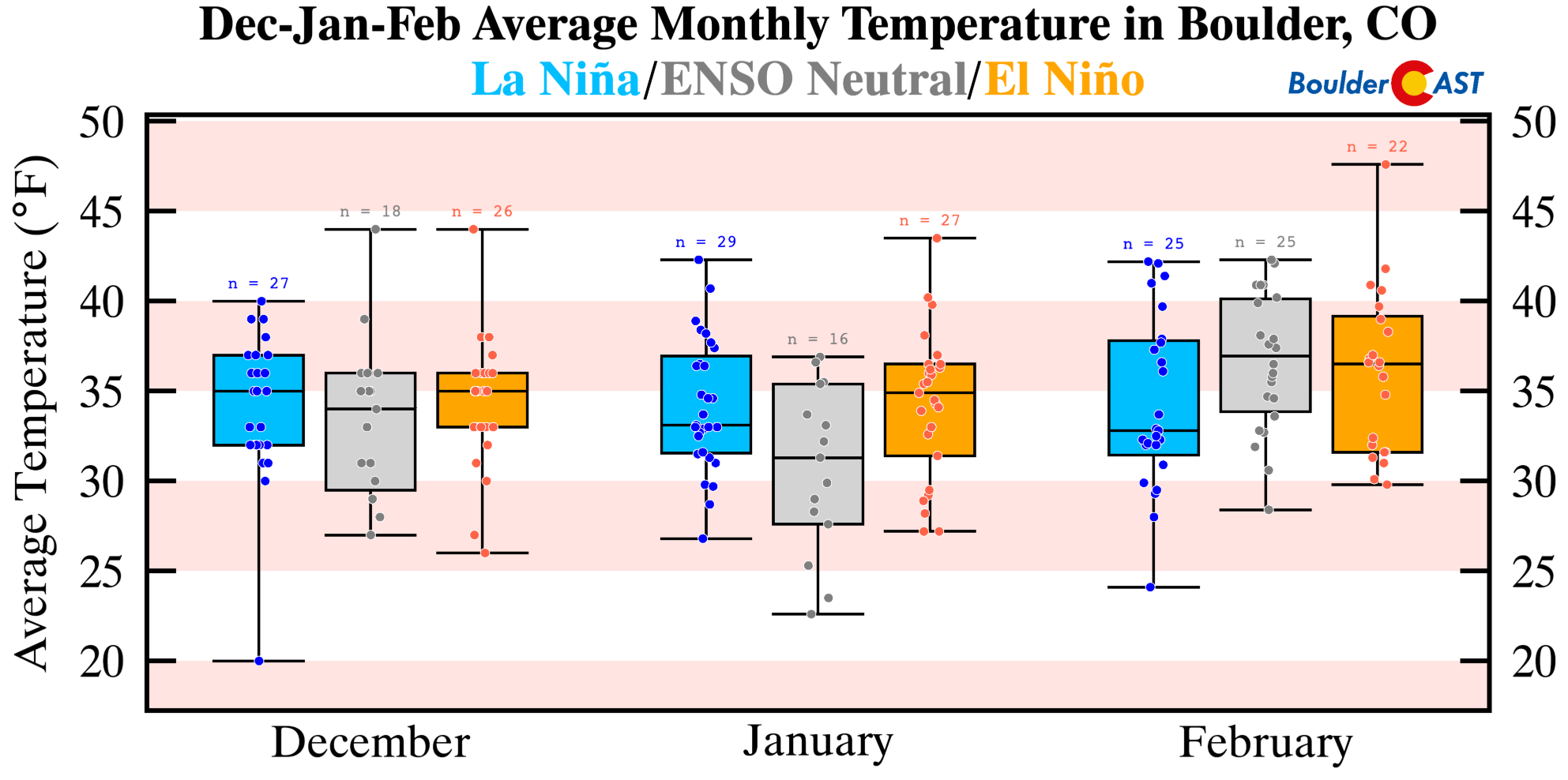
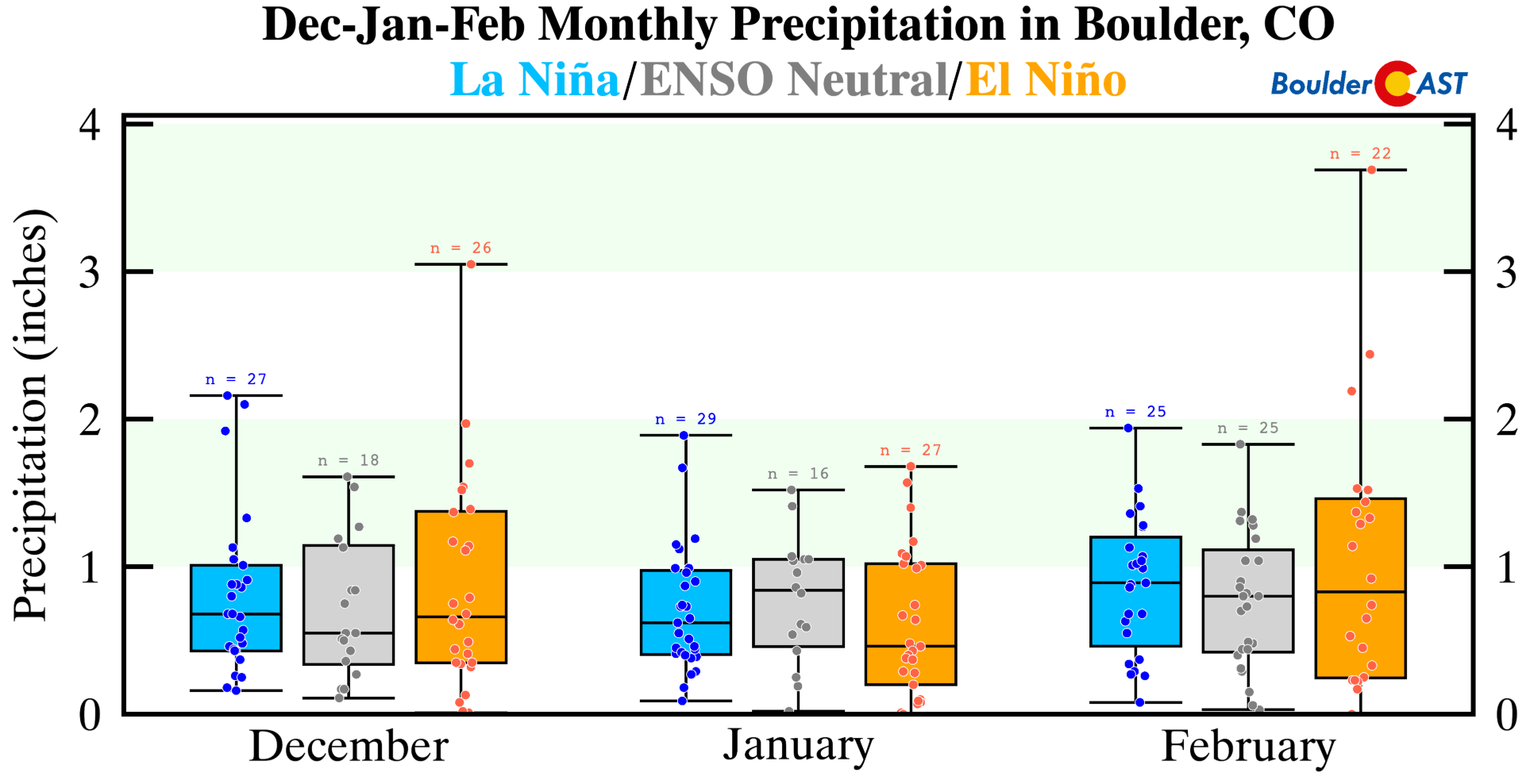
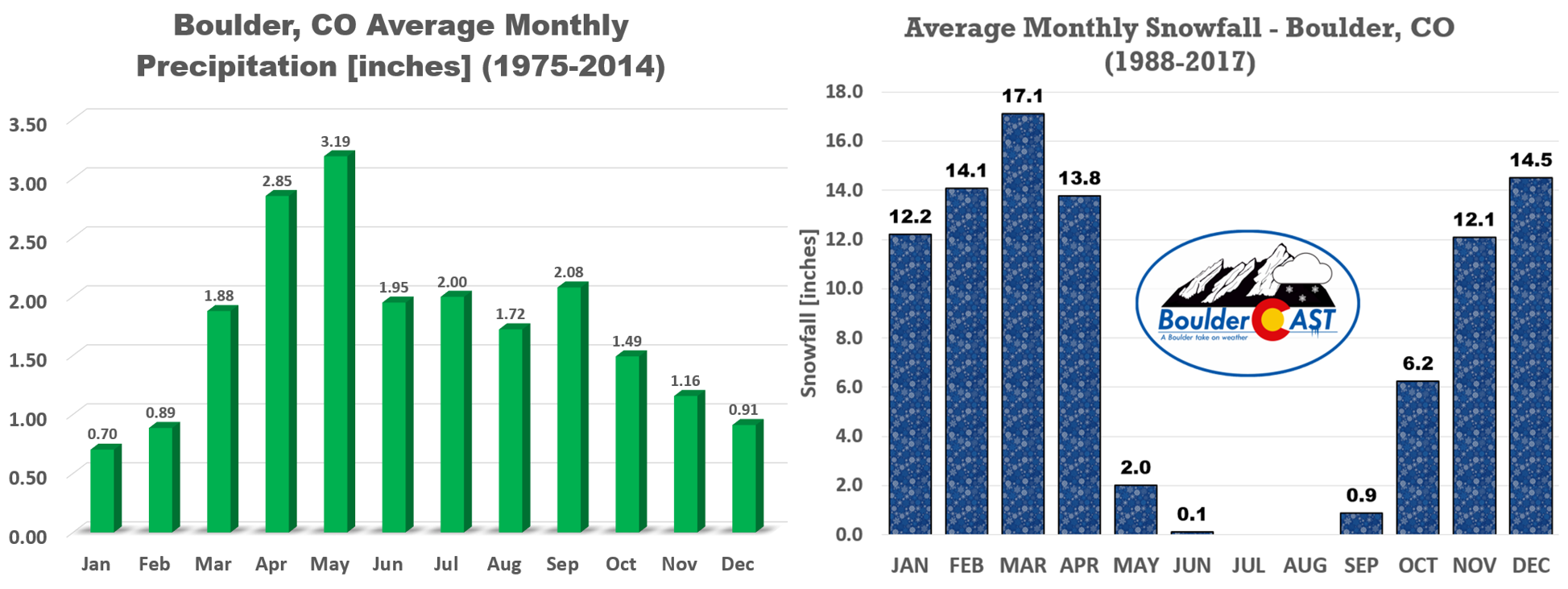
December, January and February, however, are not particularly fruitful months when it comes to precipitation for us. There could be a few notable snowstorms ahead, but winters on the lowlands of northeast Colorado are generally drier than people realize. All three months average less than 1″ of moisture in Boulder.
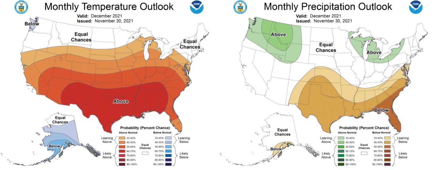
The outlook for December is somewhat promising for northern Colorado. According to the Climate Prediction Center, our area still has elevated chances for a warmer than normal December, but has equal odds for both above and below normal precipitation to occur.
We shouldn’t completely write off the entire snowfall season either. Taking a look at some of the most dismal autumns in Boulder’s past, we find the average seasonal snowfall for the following situations….
- The Top 5 Driest Falls: 70″
- The Top 5 Least Snowy Falls: 64″
- The Top 5 Latest First Snows: 74″
Compare those to Boulder’s average seasonal snowfall of 90″ for the period of 1991-2020. Based on the numbers, it’s a good bet we will indeed end with below normal snowfall this season after getting off to such a sluggish start. It’s going to be very difficult to near impossible to overcome this deficit. However, we are monitoring the threat of snow for the area early next week around December 6th or 7th. It’s still quite a ways out, but we’re hopeful. Not only for a dash of snow in the near-term, but that we can salvage the rest of the winter across the Plains and Mountains alike…
For a more detailed recap of all the happenings and data from the three 2021 autumnal months, follow the links below.
Help support our team of Front Range weather bloggers by joining BoulderCAST Premium. We talk Boulder and Denver weather every single day. Sign up now to get access to our daily forecast discussions each morning, complete six-day skiing and hiking forecasts powered by machine learning, first-class access to all our Colorado-centric high-resolution weather graphics, bonus storm updates and much more! Or not, we just appreciate your readership!

Spread the word, share Colorado weather:


You must be logged in to post a comment.