During July 2021, the summer monsoon pattern tended to favor areas further west with persistent high pressure holding over Colorado. Despite this, with a little luck involved, Boulder managed to notch a Top 20 wettest July, while most of the Front Range was very dry. Other weather highlights during the month included persistent smoke from new fires burning in the Pacific Northwest, multiple bouts of triple-digit heat, highly localized flooding in portions of Boulder, and frequent mudslides across the Mountains which has left Interstate 70 indefinitely closed near Glenwood Springs. Here’s a quick and colorful recap of our weather during July and how it relates to climatology.
Help support our team of Front Range weather bloggers by joining BoulderCAST Premium. We talk Boulder and Denver weather every single day. Sign up now to get access to our daily forecast discussions each morning, complete six-day skiing and hiking forecasts powered by machine learning, first-class access to all our Colorado-centric high-resolution weather graphics, bonus storm updates and much more! Or not, we just appreciate your readership!

Top Weather Highlights of July 2021:
HELLO MONSOON! Monsoon season officially began right at the start of July, with the heaviest rain in 2021 so far impacting portions of the Front Range on July 1st. Boulder reported more than 1.5″ of rain on this evening. Now that’s what we like to see to kick off monsoon season!
1.5" of rain fell in south Boulder Thursday from the round of showers and intense storms. Those were the heaviest rainfall rates we've had in literal years! How much rain did you get? Share a picture of the street flooding! #cowx #boulderwx pic.twitter.com/z3nY5gQ60D
— BoulderCAST Weather (@BoulderCAST) July 2, 2021
HAPPY BIRTHDAY, USA! Despite a few isolated storms around the area on July Fourth, twilight firework displays went off without a hitch as things quieted down with plenty of time to spare.
From all of us at BoulderCAST, happy Independence Day! 🎆 pic.twitter.com/6r0td9aFLB
— BoulderCAST Weather (@BoulderCAST) July 4, 2021
NEARLY TRIPLE DIGITS…AGAIN! On July 8th and 9th, another heatwave clipped northeast Colorado as high pressure developed near the Four Corners region. Some cities across the West set new all-time record highs, including Grand Junction.
BREAKING: At 4:54 PM MDT, the Grand Junction Regional Airport set a new ALL-TIME record high temperature of 107 degrees. This breaks the old all-time record of 106 from July 21, 2005. Records at Grand Junction go back to 1893. #COwx pic.twitter.com/tMo8S3Wj0p
— NWS Grand Junction (@NWSGJT) July 9, 2021
Thankfully northwest flow was present over our area preventing all-time historic heat. Denver did reach 102°F on the 8th, the city’s hottest temperature yet in 2021.
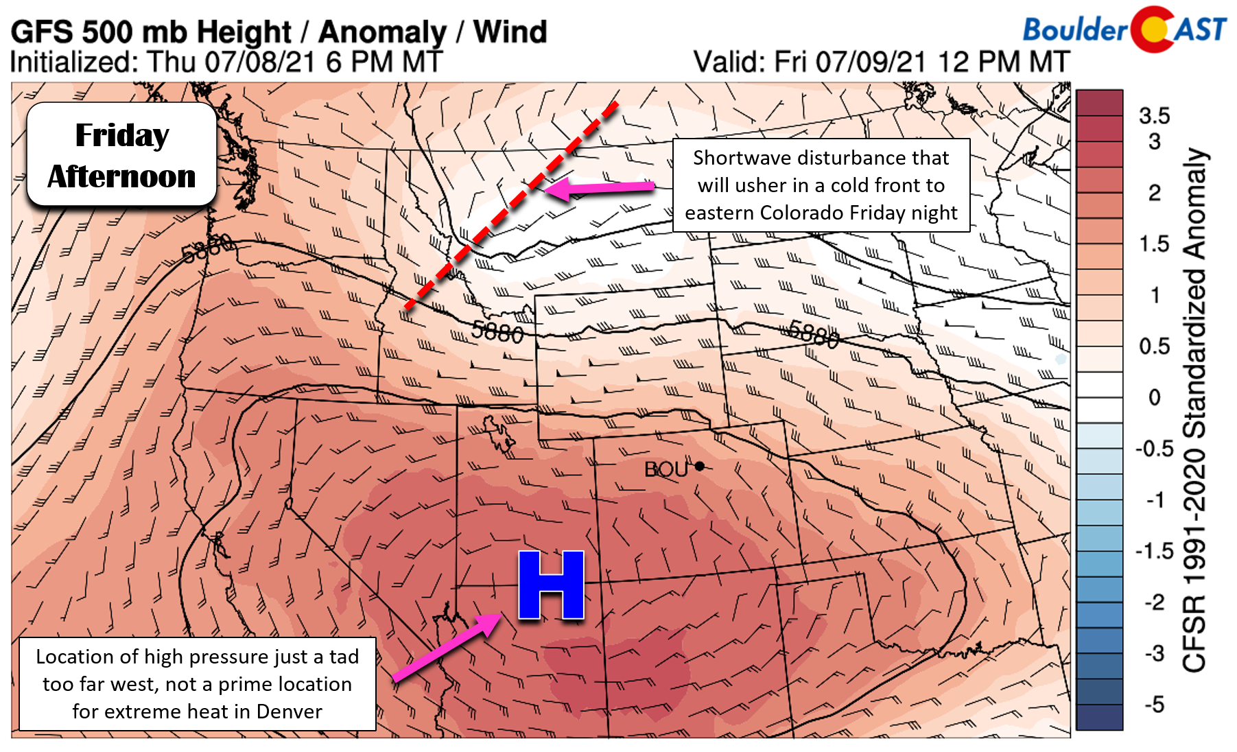
Boulder failed to touch the century mark again, coming up just a degree or two short across the city both days. We hit 99°F at BoulderCAST Station on July 8th.
Sitting at 99°F at BoulderCAST Station as of 12:30PM. This is the 4th time this summer we've hit that mark! #COwx
Follow along in the chase for the elusive 💯 in real-time: https://t.co/ibPStZnc79 pic.twitter.com/R5m5Us0nNY
— BoulderCAST Weather (@BoulderCAST) July 8, 2021
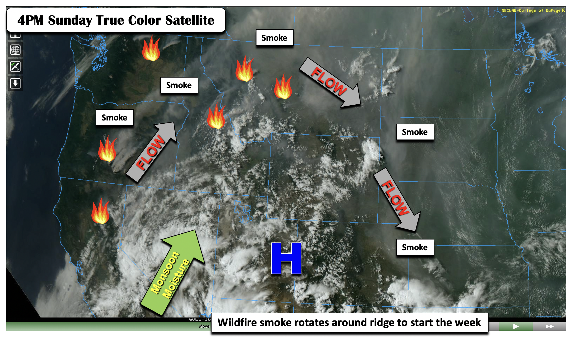
GETTING SMOKIER: Though the smoke never truly went away in early July, a ton of new fire starts in the Pacific Northwest during the prior heatwave, and even in Colorado with the Morgan Creek Fire, led to a notable increase in smoke for us beginning around July 10th. Even since, thick smoke has been a mainstay for our area.
You think it's smoky now in the skies above Denver? Wait until Sunday and Monday! 🔥
The forecast looks bleak as thick, elevated smoke arrives from MANY fires burning out of state and a few within Colorado: https://t.co/gcXXztAvZa#COwx #Smoke #Denverwx #MorganCreekFire pic.twitter.com/M0bJ4cno3V
— BoulderCAST Weather (@BoulderCAST) July 10, 2021
The sun rises Monday morning to reveal a blanket of smoke over Colorado and surrounding states #COwx #smoke pic.twitter.com/XYJ576nzQN
— BoulderCAST Weather (@BoulderCAST) July 12, 2021
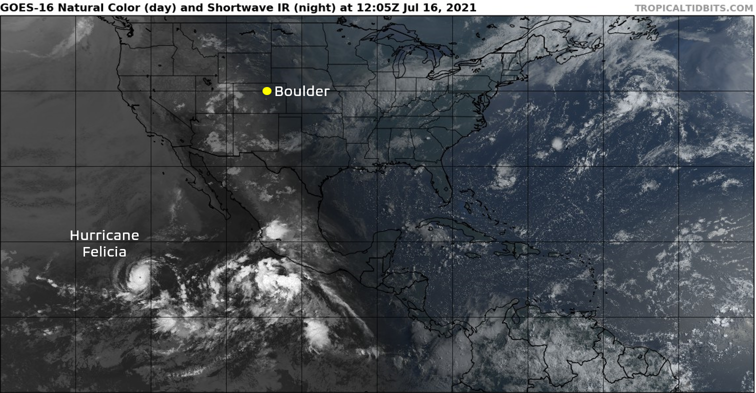
FIRST MAJOR HURRICANE: Only July 16th, Hurricane Felicia reached Category 4 status in the eastern Pacific Ocean. No impacts were felt in Colorado, or anywhere really, as Felicia never made landfall and moved out to sea and weakened. This was the first major hurricane in the Atlantic and Eastern Pacific Basins in 2021.
WHERE’S THE MONSOON? Many of you were asking this very question most of July. The monsoon moisture plume was nudged largely west of the Front Range for most of the month while out-of-state smoke continued to circulate around high pressure and fill our skies. The heat was unrelenting it seemed and rain was hard to come by with non-irrigated vegetation turning brown.
Trust us, the monsoon has truly been raging this summer, just not for Front Range Colorado. Check out out the percent of normal precipitation map for July below. Note the below normal precipitation for most of the Front Range. However, Arizona, southern California, Nevada and even portions of southwest Colorado were wet in July.
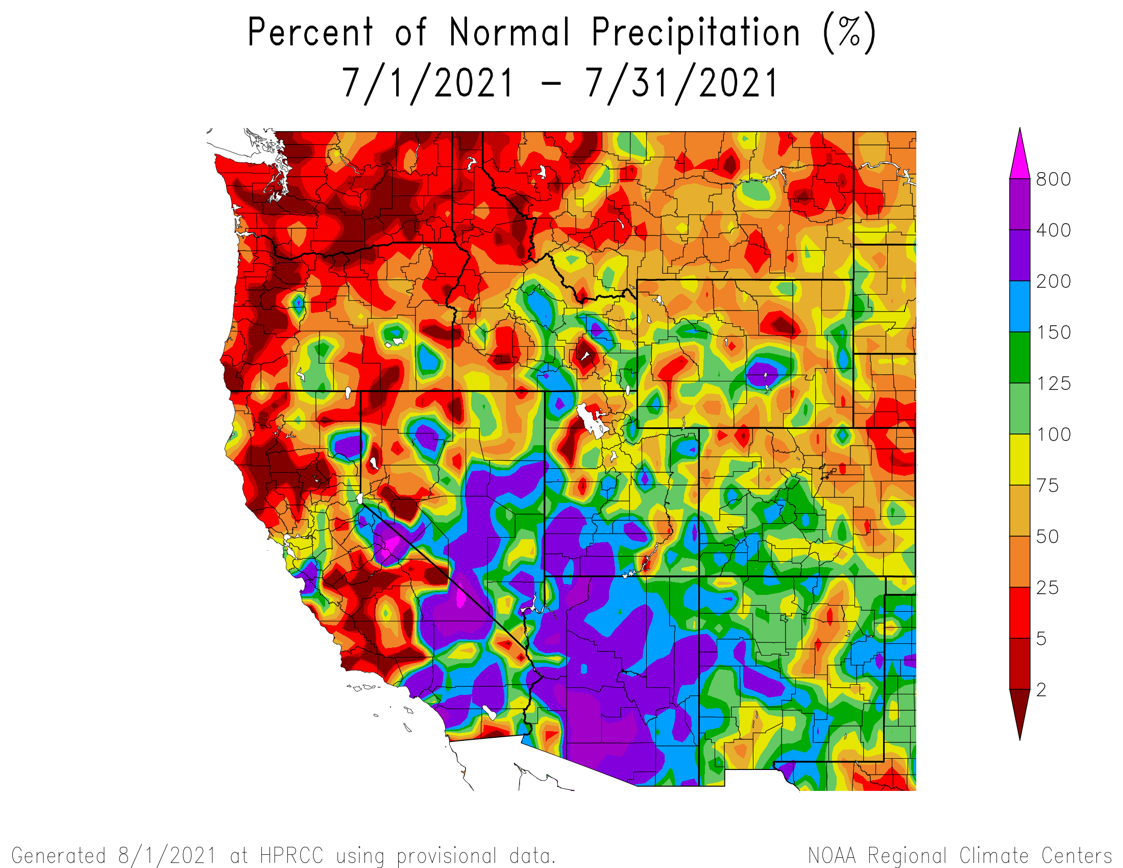
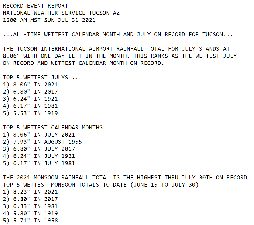
Tucson Arizona, for example, set a new all-time monthly precipitation record in July with more than 8″ of rain falling….a staggering amount considering its desert climate! To put this into perspective, the last time Boulder had 8″ of rainfall in a single month was during the multi-day flood of September 2013. The previous 8″+ month to that was all the way back in May 1995! As we foretold, this roaring Arizona monsoon is typical for an ENSO Neutral summer following a La Niña winter.
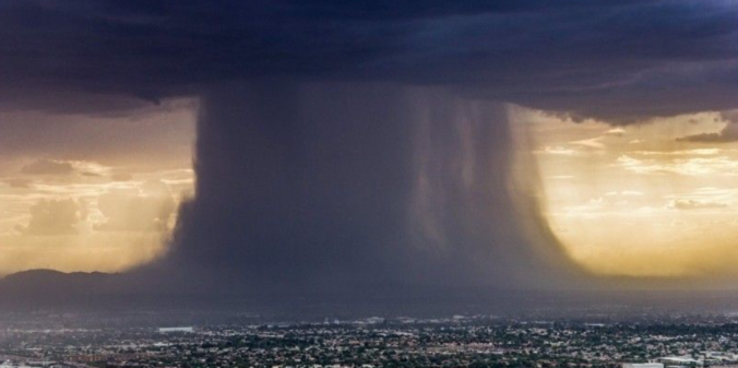
SURPRISE! MAJOR BUT LOCALIZED FLOODING IN BOULDER: Only July 25th, a slow-moving isolated thunderstorm in Boulder developed almost out of the blue during the evening hours. This thunderstorm spawned as a result of an outflow boundary originating from 70 miles to the east near Limon. Tapping into deep monsoon moisture on a relatively stable evening, this cell quickly produced between 2 and 3″ of rain in just over one hour’s time in west-central portions of Boulder.
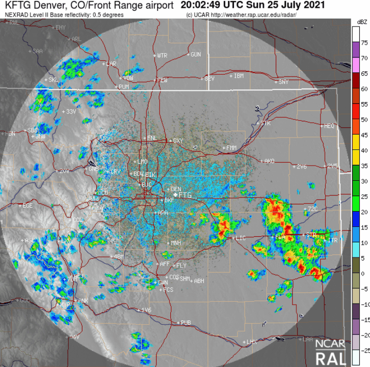
This much rain this fast was bad news for the city and caused minor street flooding in the area of 9th Street from Canyon to Balsam in west-central Boulder.
Boulder, #Colorado received some heavy #rain in the afternoon on Sunday.
They got two inches of rain in just one hour, that led to some street #flooding that can be seen here in this video! #monsoonseason #COwx #flood pic.twitter.com/rWbYHo0zwe
— WeatherNation (@WeatherNation) July 26, 2021
ONE LAST TRIPLE DIGIT FOR DENVER: On July 28th, Denver hit 100 degrees again for the 5th time this summer (Boulder did not). This puts 2021 into third place all time for most 100 degrees days in a calendar year. Both Boulder and Denver average less than one day in the triple digits each year, so this summer has been quite anomalous in the Mile High City!
100-degree days this year: Denver 5, Boulder 0 https://t.co/ekI9ksD3Uz
— BoulderCAST Weather (@BoulderCAST) July 28, 2021
HEAVY RAIN TO FINISH THE MONTH: The final two days of July saw atmospheric conditions align favorably for flash flooding — deep monsoon moisture and weak upper-level winds. On both July 30th and 31st, huge portions of Colorado were under Flash Flood Watches and dozens of Flash Flood Warnings and Flood Advisories were issued.
It's ACTIVE early evening across the entire state of Colorado. At least 8 Flash Flood warnings (mainly in burn scars), 2 Severe T-Storm Warnings, and ~50% coverage of Flash Flood Watches statewide! #COwx pic.twitter.com/8KzUx2zyIw
— BoulderCAST Weather (@BoulderCAST) July 30, 2021
The state’s many recent burn scars were hit particularly hard.
Very heavy rainfall is occurring across the Cameron Peak Burn Area. Roads are beginning to wash out. Follow all evacuation orders if you are in this area! #cowx https://t.co/NgdBDg6p2g
— NWS Boulder (@NWSBoulder) July 30, 2021
Not surprisingly, both directions of Interstate 70 near Glenwood Springs remain an absolute disaster and major issue for Colorado and travelers due to daily mudslides and closures from heavy rain falling over the Grizzly Creek Fire burn scar. Right now that stretch is closed with no definitive opening date. So much mud, rocks and water have impacted the highway, it’s possible it could be structurally compromised at this point.
CDOT: New images of I-70 thru Glenwood Canyon. Details #KDVR #KWGN pic.twitter.com/l2oIDQEXO2
— jimhooley (@jimhooley) August 2, 2021
Boulder received about a half inch of rainfall on those final two days, but localized spots saw more than 4″ near Erie and Broomfield. Overall, it was a wet end to the month to say the least. Much needed moisture was dished out across the entire region. If only it could have come without the flooding and mudslides!
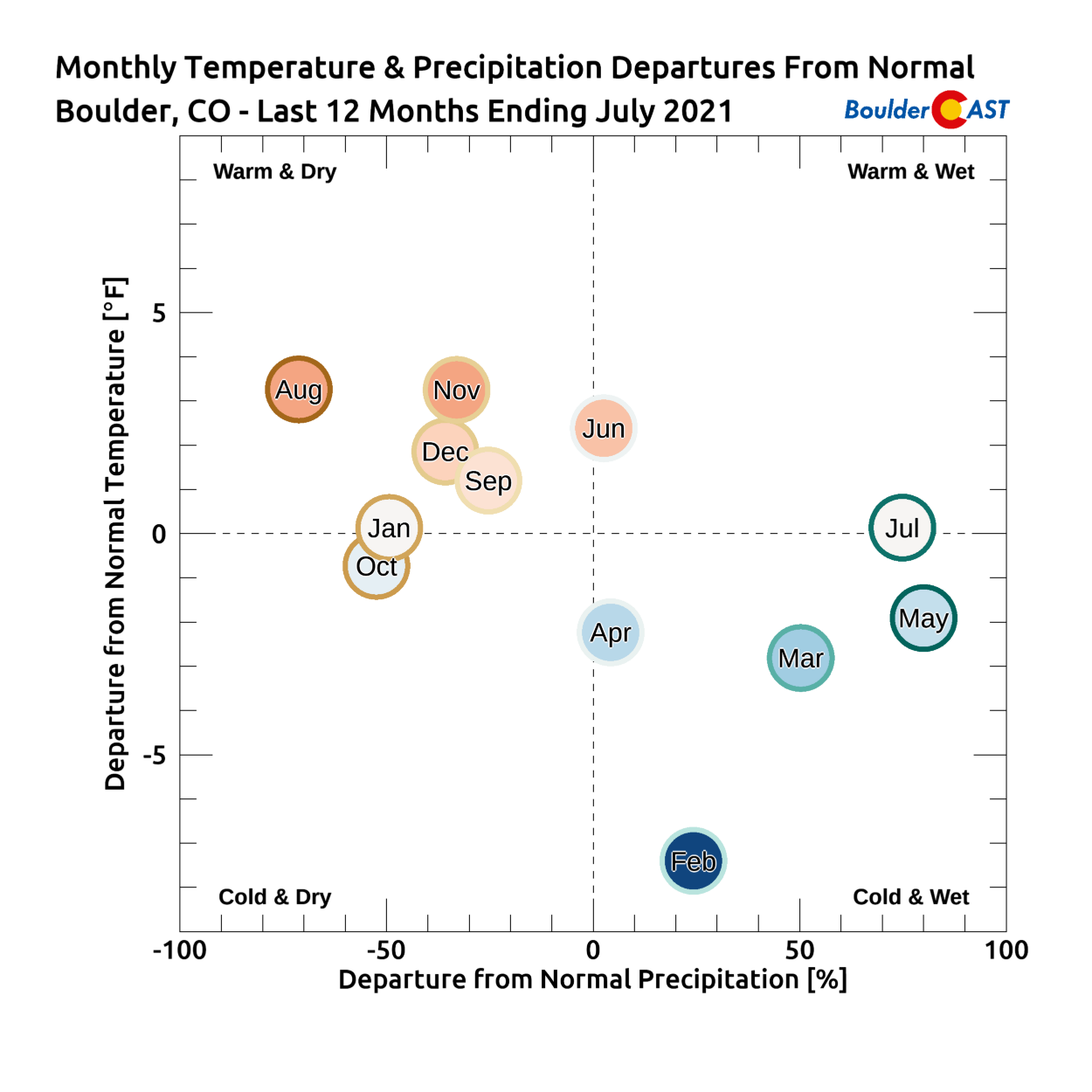
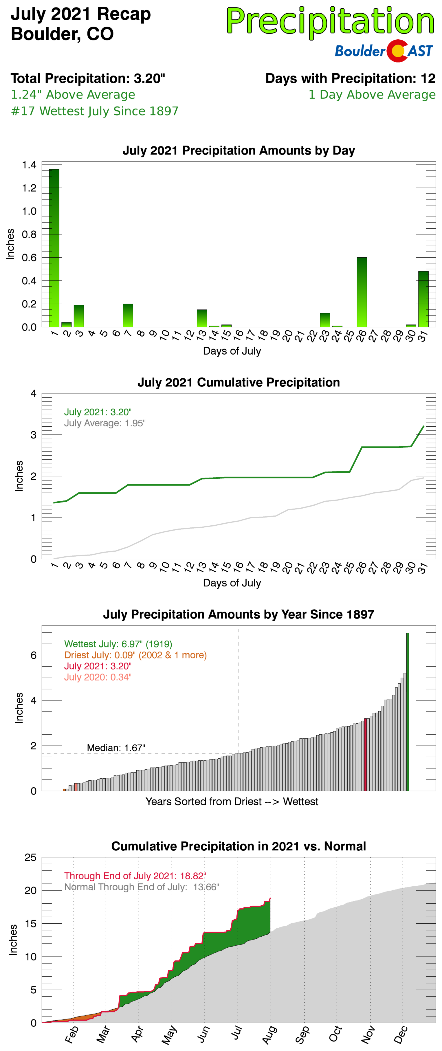
BOULDER, AND ONLY BOULDER, WAS WET: Boulder was one of the few bright spots in the Denver Metro area for July, concluding the month with above normal precipitation. In fact, July 2021 was Boulder’s 17th wettest since the late 1800’s. However, as you can see below, with very few exceptions, most Front Range cities were much drier than normal during the month. For example, Denver International Airport reported just 0.34″ of rain which ranks in the top 20 driest July’s for Denver.
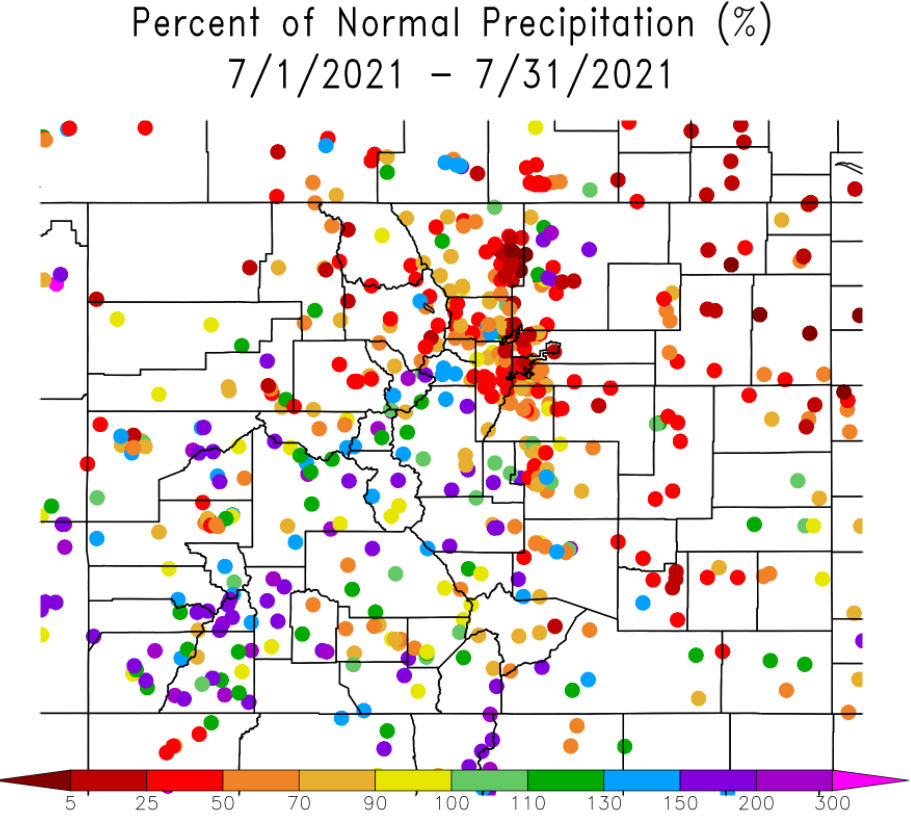
July 2021 was the 6th consecutive month of above normal precipitation in Boulder, a trend which began back in February.
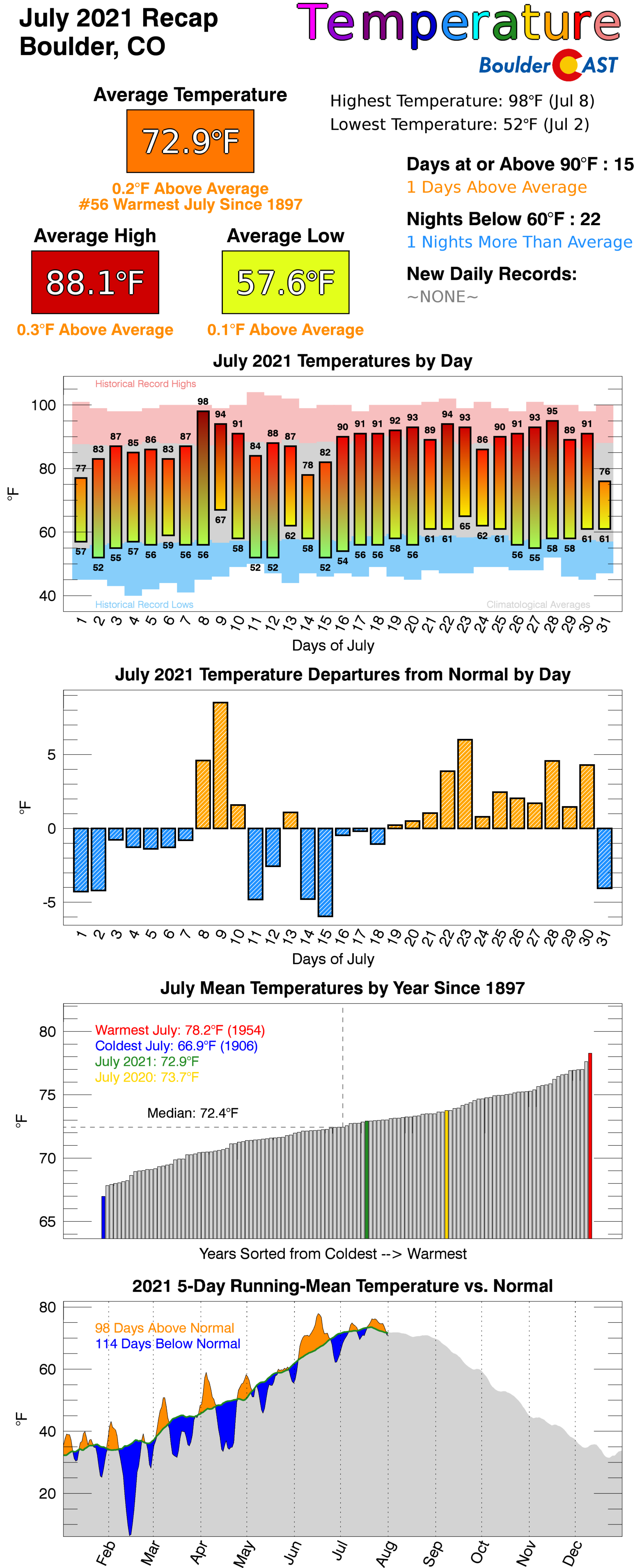
July 2021 Recap Graphics:
Spread the word, share Colorado weather:
We discuss Boulder and Denver weather every single day on BoulderCAST Premium. Sign up today to get access to our daily forecast discussions every morning, complete six-day skiing and hiking forecasts powered by machine learning, access to all our Front Range specific weather models, additional storm updates and much more!


You must be logged in to post a comment.