
Here’s a quick and colorful rundown of our weather during February 2021 and how it relates to climatology.
Help support our team of Front Range weather bloggers by joining BoulderCAST Premium. We talk Boulder and Denver weather every single day. Sign up now to get access to our daily forecast discussions each morning, complete six-day skiing and hiking forecasts powered by machine learning, first-class access to all our Colorado-centric high-resolution weather graphics, bonus storm updates and much more! Or not, we just appreciate your readership!

Top Weather Highlights of February 2021:
JET-SNOW IN FAR SOUTHERN METRO: The first taste of winter weather to arrive during the month occurred on February 3rd in the form of jet-forced snow bands. Most areas saw no snow from this event as the band was highly localized southeast of Denver.
RADAR UPDATE 9PM: A band over very heavy wet snow has developed on the southeastern fringes of the Denver Metro area. With snowfall rates of 1"+ per hour in this band, localized spots could see 2-4" of snow tonight. Nothing happening on the north side of town though 🙁 #COwx pic.twitter.com/5OZZxjmnuk
— BoulderCAST Weather (@BoulderCAST) February 4, 2021
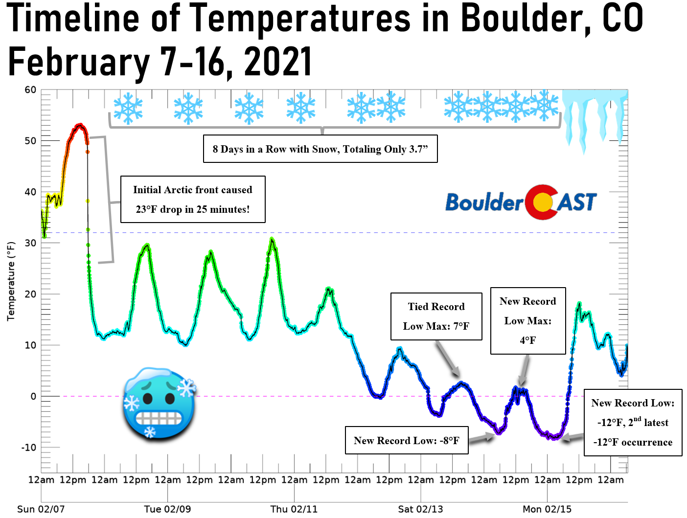
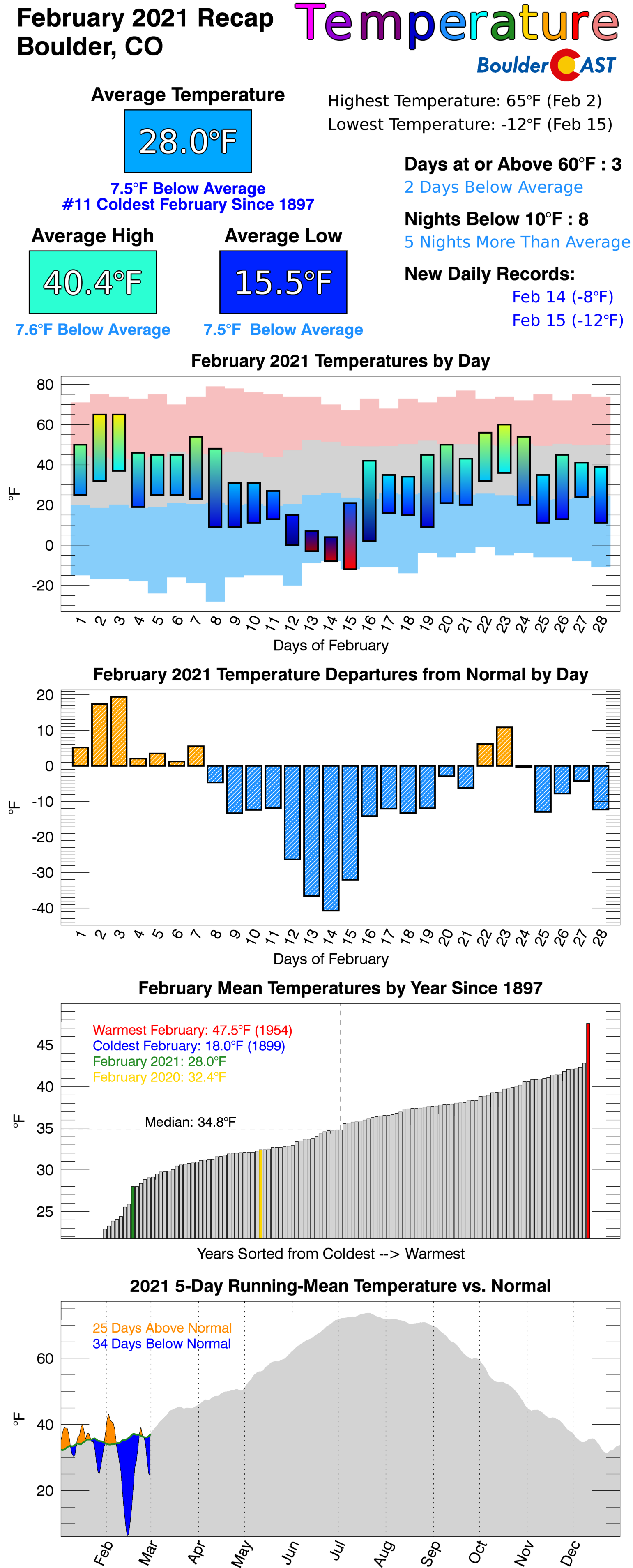
THE DEEP ARCTIC FREEZE: February 7th was a day that changed everything. An off-shot of the Polar Vortex dove into the central United States and kicked into Colorado rather abruptly. It took more than eight days for Boulder and some portions of the Metro area to get back above freezing. There were numerous record cold temperatures broken and eight straight days with snow. For more information about this historic cold air outbreak, for Colorado and the country as a whole, check out our in-depth summary post HERE.
CONVECTIVE SNOW!? After a disappointing amount of snow fell in our area during the Polar Vortex outbreak the week prior, we got more snow than south Texas and Louisiana on February 17th! The atmosphere was primed for an explosion of snow that evening in the Foothills and western Denver Metro area and it did not disappoint this time. Favorable conditions for convective heavy showers for a short window produced up to a foot of snow in some areas. Read our recap post of this snowfall event HERE.
HEADS UP: Difficult-to-predict heavy convective snow showers will be around Boulder and Denver Wednesday afternoon and evening ❄️⚠️
Read our full forecast: https://t.co/3JjsjzPHU0#COwx #Snow #ConvectiveSnow pic.twitter.com/KBcv5BBvIY
— BoulderCAST Weather (@BoulderCAST) February 17, 2021
The profile overhead today is a dangerous one w/ a rapid decrease in temps all the way up to the stratosphere. The low-level upslope interacting w/ the terrain *should* be enough to fire pockets of heavy snow from late afternoon thru evening near & west of the Boulder area #cowx pic.twitter.com/06xR9Rz3MR
— BoulderCAST Weather (@BoulderCAST) February 17, 2021
ANOTHER JET SNOW: A weak storm system and associated jet streak moved across Colorado on the evening of February 20th producing bands of moderate snowfall for a brief period.
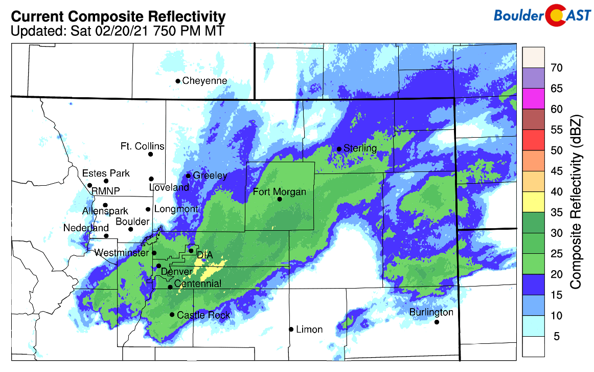
Radar animation from February 20, 2021 in the evening
As expected, southeastern portions of the Denver Metro area were hit hardest:
Here's a look at last night's snow totals. Officially 0.4" in Boulder, 1.2" in Denver. Highest reports came out of Aurora/Parker area at 3 to 4" #COwx #Snow pic.twitter.com/SSLhMfXPeA
— BoulderCAST Weather (@BoulderCAST) February 21, 2021
A SURPRISE FOOT OF SNOW IN DENVER! On the evening of February 24th, a rare wintertime wind phenomenon specific to the Front Range led to an explosion of heavy, slow-moving snowfall across the Denver Metro area. Some locations that were only expecting an inch got a foot! For more details on why this storm boomed so hard in the Denver area, read our recap post HERE.
WINTER STORM RECAP: What caused such an explosion of heavy snow in the heart of Denver last night? 💥 Let's talk about it: https://t.co/MEF95WjneD#COwx #COsnow #Boulder #Boulderwx #HeavySnow pic.twitter.com/oQu6N6yep4
— BoulderCAST Weather (@BoulderCAST) February 25, 2021
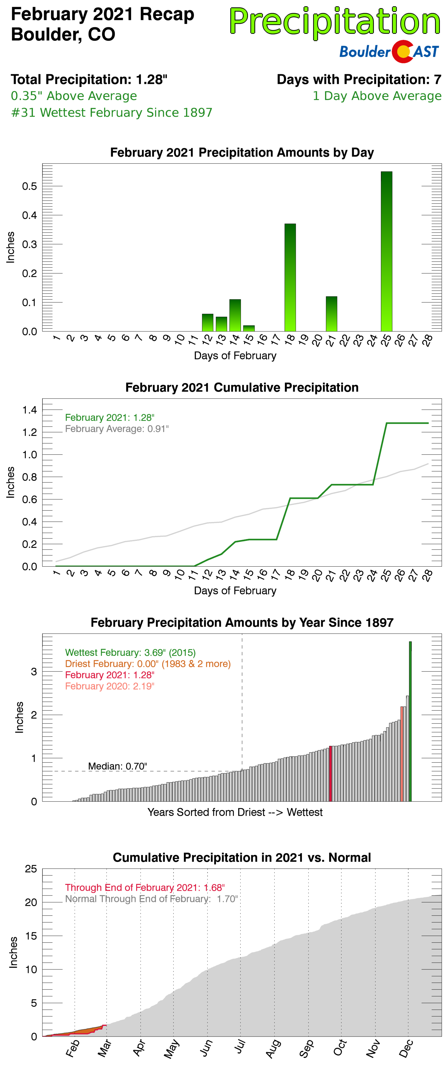
This was the storm that really saved February from being the 8th straight month of below normal precipitation for the area. Instead, this big snow event late in the month boosted much of the lower elevations above normal for the month. In the heart of winter, a typically fairly dry season for us, sometimes one storm is all it takes!
February 2021 Recap Graphics:

Spread the word, share Colorado weather:
We discuss Boulder and Denver weather every single day on BoulderCAST Premium. Sign up today to get access to our daily forecast discussions every morning, complete six-day skiing and hiking forecasts powered by machine learning, access to all our Front Range specific weather models, additional storm updates and much more!


You must be logged in to post a comment.