
No one fully expected the Arctic airmass that arrived last Sunday evening, a solid nine days ago, to remain entrenched across the Denver Metro area for this long…but it did! We take a look back at the series of events as they unfolded over the last week, including the first regional wildfires of 2021, two dollops of light snow and the coldest temperatures for our area since 2014.
Sunday Feb 7th
This is where it all began. It started like any other typical February day with morning temperatures in the 20’s. However, something was brewing. It quickly warmed up into the 50’s with strong downslope winds and localized blowing dust across the Metro area. A few “small” human-caused brush fires flared up in the afternoon and spread rapidly. Fortunately, a significant weather change was looming to help the firefighters….
UPDATE: Multi-mission aircraft (MMA)flight over the #MorrisonRoadFire (also known as the #BearCreekFire) has the fire at 446 acres tonight. This video shows what it was like on the ground this afternoon. Fire size could be adjusted when crews get a better look after sunrise. pic.twitter.com/1re0K6u0Ja
— WestMetroFire (@WestMetroFire) February 8, 2021
By afternoon, the Arctic front was surging southward towards Denver which was something we warned you about a week in advance. By evening, the front had moved through the entire area.
Just a little bit longer… Winter is coming! (the feel but NOT the snow) #cowx pic.twitter.com/LLThT98dtH
— BoulderCAST Weather (@BoulderCAST) February 8, 2021
In most cases, the temperature dropped 25 to 35 degrees in less than one hour, including at our own BoulderCAST Station. The last time we were above freezing was just before the six o’clock hour. We didn’t know it at the time, but those would be the last moments above freezing for the next 8 or 9 days!
52°F ->19°F in 80 minutes. At one point, the temperature dropped 23°F in just 20 minutes #COwx #Boulderwx #ArcticFront pic.twitter.com/1KfwEGsFS1
— BoulderCAST Weather (@BoulderCAST) February 8, 2021
Monday Feb 8th – Wednesday Feb 10th
The Arctic air was fully entrenched by Monday morning with temperatures below 6500 feet elevation sitting in the teens.
The Arctic airmass across the area early Monday morning is only ~1000 feet deep. This can be gleaned from the regional temperature obs spread across the terrain, or from the weather balloon data launched this morning at Stapleton. 40°F above, 12°F within #COwx #Boulderwx pic.twitter.com/mMfYh8vguq
— BoulderCAST Weather (@BoulderCAST) February 8, 2021
That was alright, though. There was overwhelming consensus in the weather models that this Arctic air would retreat slightly, allowing for warmer westerly flow to scour away the bitter cold temperatures by afternoon. This unfortunately never happened. Day after day, the models got this same projection wrong and the frigid airmass persisted across the Front Range. It was starting to feel like the movie Groundhog Day there for a while. Each day started with freezing fog and snow flurries. By afternoon, clouds slowly cleared to give way to some sunshine, but the Arctic chill never departed fully. Each night, the cold, dense air oozed even more strongly up against the terrain west of Denver. The net result was day after day of completely busted forecast temperatures! Monday, Tuesday, and Wednesday all saw high temperatures in the mid to upper 20’s.
Thursday February 11th – Friday Feb 12th
Thursday and Friday were more of the same. Our Groundhog Day movie analogy lived on. It was even colder and clouds were more stubborn to clear out in the afternoons. Highs Thursday were in the teens, while Friday was in the single digits. The first of two light snow events produced about 1″ of snow in Boulder Thursday evening and night, but less than 1/2″ fell elsewhere across the Denver Metro area.
Here's a look at overnight snow totals from @CoCoRaHS which were highest northwest of Denver into Boulder. Flurries and spotty snow showers are possible through Friday night. The main round of accumulating snow comes Saturday afternoon into Sunday morning #COwx #Snow pic.twitter.com/7XnBCvexDW
— BoulderCAST Weather (@BoulderCAST) February 12, 2021
Saturday February 13th
Saturday was an extremely cold and largely cloudy day. You can see in our weather history graphic below the “sharp” drop in temperature around 2:45AM. This was a reinforcing shot of Arctic air that set the stage for an even colder day. The official high temperature in Boulder was 7°F, tying the existing low maximum temperature for the date. Because Boulder’s record keeping goes off UTC time, this temperature actually occurred on Friday evening the day before. We know, confusing right. The “real” high temperature on Saturday occurred at midnight and was just 3°F. Snow was expected to develop by early evening and continue through the overnight hours, which it did for the most part.

Sunday February 4th
By Sunday morning, it was clear the second round of snow was a bit of a flop. Most Front Range locales picked up between 1 and 3″ of new snow from Thursday night into Sunday. However, 5 to 10″ fell in the higher Foothills and west of the Divide. Our three-day snowfall forecast map is shown below with storm totals overlaid in boxes.
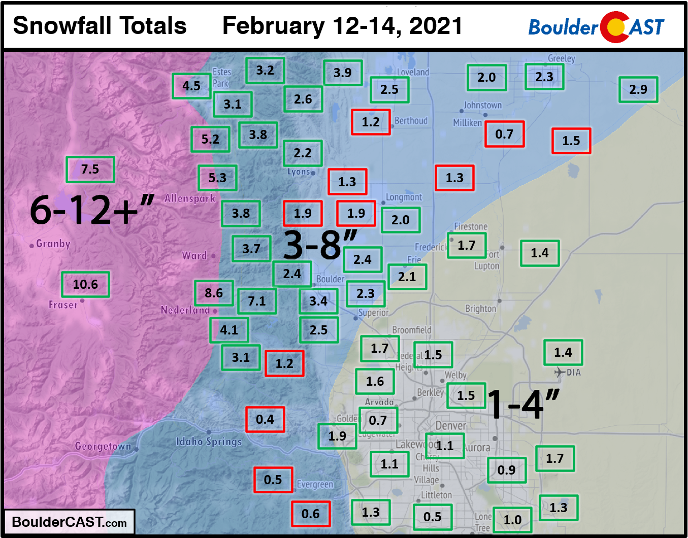
In our storm post-mortem discussion, we attributed the lack of snow to the grand finale of Arctic air just not being strong enough to make it up and over the Continental Divide. Without this facet, areas around Denver were not able to tap into much if any Pacific moisture aloft. The bitter cold, bone-dry, and now completely isolated Arctic airmass produced just very light snow across the region with less than half of the expected moisture falling regionwide. By the end of the weekend which slammed much of the country with winter weather…. Seattle, San Antonio, Little Rock, Austin, Memphis, Shreveport, Oklahoma City, and Miami all picked up more snow than Boulder. Okay, that last one might not be true. But the others are and the feeling of disappointment definitely hits hard. The dismal snow season in Front Range Colorado continues for at least a little while longer.
Going out on a limb here: it's a Critical Weather Day for @NWSWPC. What a mess nationwide, including Colorado #COwx #ArcticBlast pic.twitter.com/LuHrcStNAc
— BoulderCAST Weather (@BoulderCAST) February 13, 2021
Where there is failure, there is opportunity! And that’s exactly what we saw Sunday night. That weaker push of Arctic air allowed skies to clear out much earlier than expected. This opened the door for overnight lows to tank Sunday night…and tank they did!
Sunday’s high temperature was just 4°F in Boulder which shattered the existing low maximum record by 10 degrees for the date. Sunday’s minimum temperature in Boulder was -8°F setting a new daily record low.
Monday February 15th
The coldest temperatures all along were expected to be Monday morning. Skies were partly to mostly clear across the area producing overnight lows ranging from -10°F to -30°F (!) across northeast Colorado. Winds chills were dangerously cold, so we hope you didn’t have to venture outside and were able to secure your pets and livestock. Boulder set a new record daily low temperature at -12°F. Denver’s official minimum temperature was -16°F which was not a new record.
It's very cold this morning, especially on the plains! Make sure to dress properly for the cold if you're going outside. #COwx pic.twitter.com/NnfhzHteJV
— NWS Boulder (@NWSBoulder) February 15, 2021
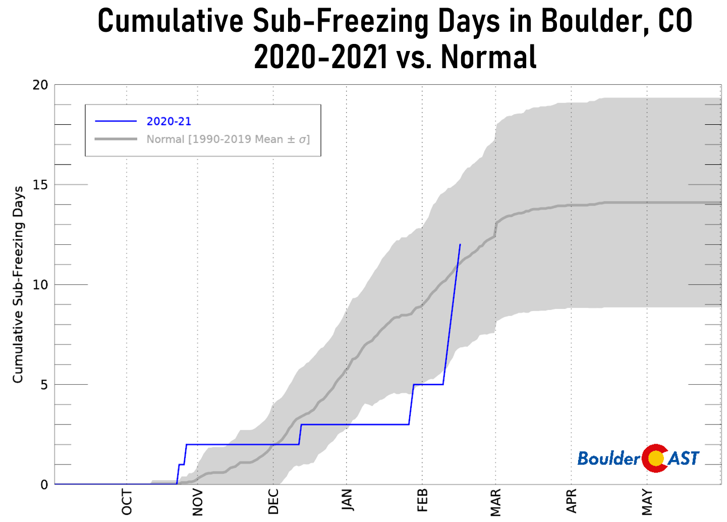
Afternoon highs Monday varied across the Denver Metro area from the upper teens to lower 30’s, but it was sunny everywhere. In Boulder, the high was 21°F marking the 7th official day with below freezing temperatures. In case you’re wondering, the record for most consecutive days below freezing in Boulder is 12 days set back in January of 1929. This week’s stretch of seven days ranks in 12th place for longest sub-freezing streak. Can you imagine those 11 other times when it was this cold for even longer? We don’t want to…
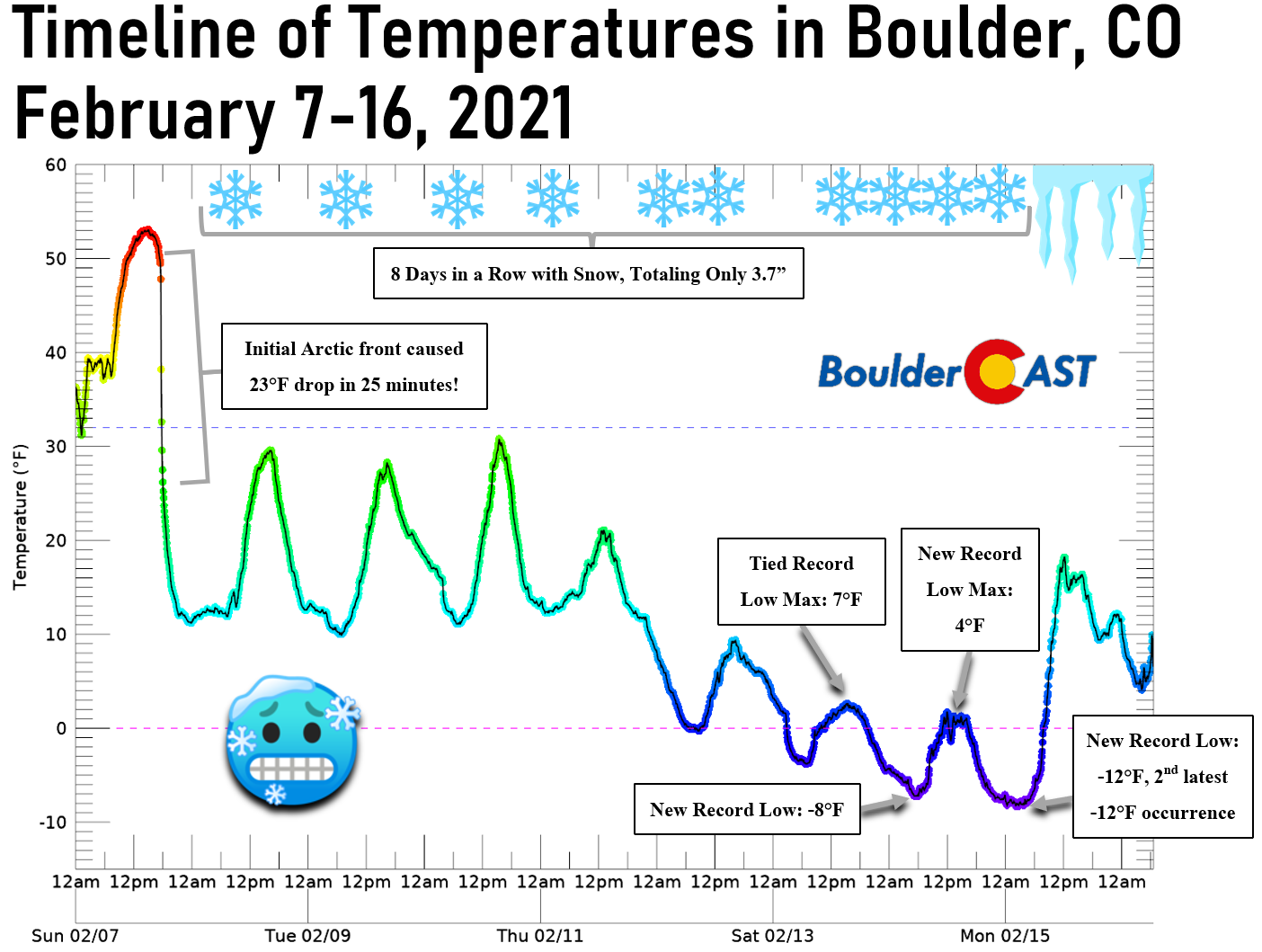
Week-Long Recap Graphic
The graphic below summarizes everything that unfolded in Boulder this week, with four cold weather records set and some other interesting tidbits.
A slight warming trend is already underway, though snow is staying in the forecast. We’re currently keeping an eye on our next two systems which will offer the chance of convective snow showers for the area. After a chance at a few non-accumulating snowflakes Tuesday evening, some areas could pick up an inch or two later on Wednesday. We’ll talk more about Wednesday light snow in another forecast update soon. For now, let’s root for warmer weather! As always, subscribe to get instant email notifications when our new forecasts go live, and don’t forget to follow us on Facebook or Twitter.
Help support BoulderCAST and save 25% with promo code FRIGID (Ends Friday February 19th)
Help support our team of Front Range weather bloggers by joining BoulderCAST Premium. We talk Boulder and Denver weather every single day. Sign up now to get access to our daily forecast discussions each morning, complete six-day skiing and hiking forecasts powered by machine learning, first-class access to all our Colorado-centric high-resolution weather graphics, bonus storm updates and much more! Or not, we just appreciate your readership!

.
Spread the word, share Colorado’s crazy weather:
.


You must be logged in to post a comment.