
Snowfall amounts over the last few days were largely disappointing across the Denver Metro area, mostly coming in below expectations. We discuss what happened to all the snow, look ahead to the coldest temperatures which are still to come and discuss why Sunday night will actually be warmer than last night in some locations.
At a Glance:
- Snowfall over the last few days was disappointing and below expected amounts, likely caused by a misstep on forecasting the depth/oomph of the Arctic air
- Daily records for low temperatures have already been broken Saturday and Sunday in both Boulder and Denver
- Temperatures Sunday night into Monday will plummet further across the Front Range with more records expected to be broken
- Warmer weather, at least comparatively, lies ahead this week
The snowstorm(s) flopped
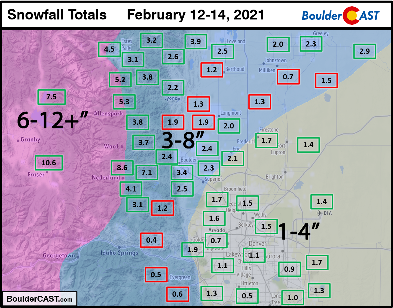
Mother Nature dangled a snowy carrot in front of us this weekend, but then abruptly took it away. Most locations ended up seeing less snow than expected over the last few days, or at least on the low end of our forecast. It’s just been that kind of year. The first round of snow Thursday evening and night produced up to 1″ of snow around Boulder and north of Denver. The second, stronger wave of snow produced just 1 to 2″ across the region. When it was all said and done, the Denver Metro picked up 1-3″ while the Foothills saw anywhere from 1 to 8″, with higher amounts owing to a little spill-over from the Continental Divide (which was expected). Austin, Seattle and Amarillo all picked up more snow than Boulder this weekend. This is truly rock bottom…
Shown below is our snowfall forecast map issued Thursday morning with actual storm totals overlaid in boxes. Green boxes indicate that our forecast verified to within one inch of the observed snowfall. Red did not.
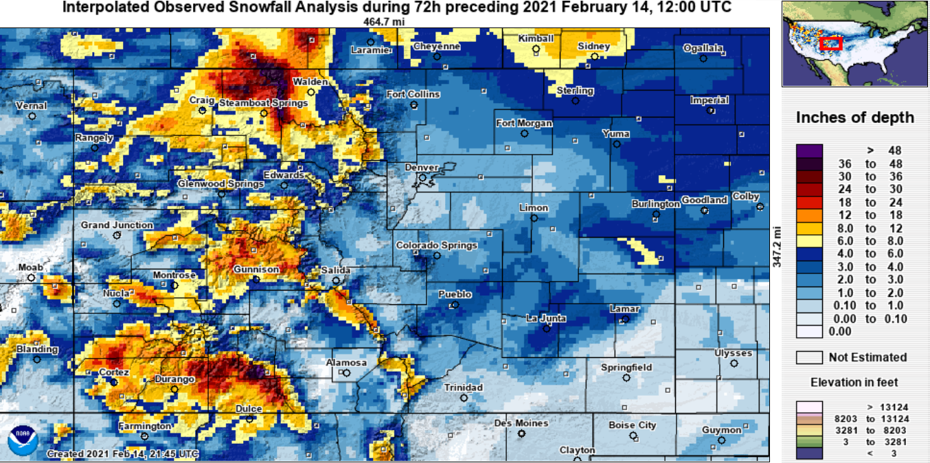
So what happened? Well, our best guess is that the push of the Arctic air from the east wasn’t as strong as the models were showing. Not only did this weaken the upslope component for the Front Range, it shifted the focus of the over-running further out across eastern Colorado. The 3-day snowfall total map for all of Colorado below shows a clear bias of higher amounts east of the Metro area, sadly.
From looking at the morning low temperatures on Sunday, we see that the Arctic air largely didn’t make it up and over the Continental Divide. While certainly you couldn’t cook an egg on the hood of any cars in Granby this morning , it was above zero in Middle Park and actually about 30°F warmer than a like elevation on the other side of the Divide. This isn’t surprising. Cold, dense Arctic air is not easy to get up and over a 12,000+ foot topographic barrier. Every single weather model really dropped the ball on this one, and as a result, so did we. Arctic outbreak events this cold are quite rare. In the weather world, the less “experience” models have with a particular scenario, the lower the accuracy (i.e. the 2013 Colorado Flood). This may have factored into the poor forecast as well.
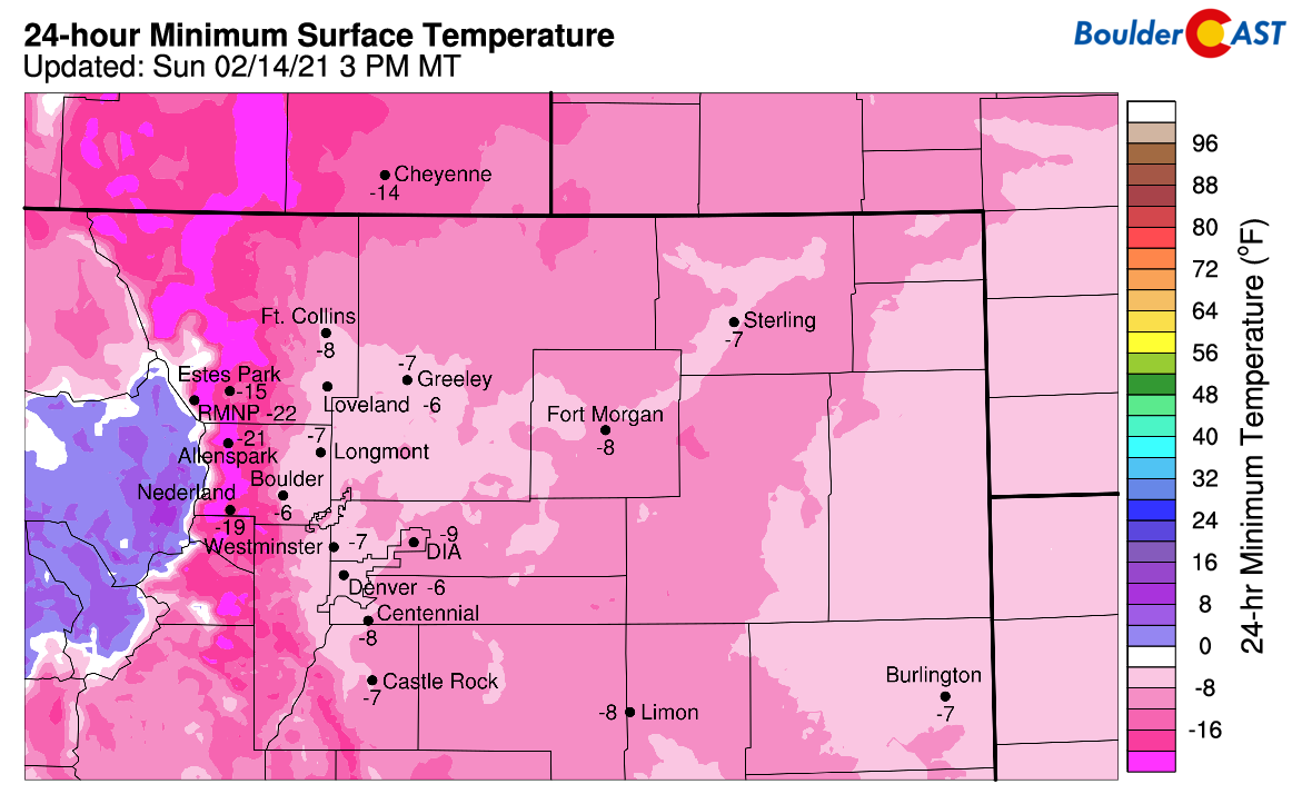
Overnight lows Saturday night into Sunday
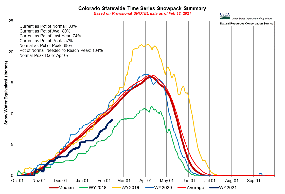
Finally, the Mountains and many ski resorts did see big totals over the last few days. Steamboat, A-Basin, and Aspen all reported around a foot of new snow. Way down in the San Juans, Wolf Creek checked in with nearly 3 feet of new powder… if you are one of the four people that believe Wolf Creek snow reports, that is. Overall, this month we’ve seen continued but still very minor improvement in our mountain snowpack statewide and in the local South Platte Basin as well. Every single bit of snow helps, but at this point, it just hasn’t been enough to stave off the potentially devastating fire season which is knocking on our door.
The coldest night since 2011 is brewing in Boulder
The busted snowfall event has opened up the door for a bitter cold night ahead Sunday night. We’ve already seen record cold temperatures for February 14th broken in both Boulder and Denver at -8°F and -10°F, respectively. The official numbers are not in yet, but we’ll also likely be breaking the record for the lowest maximum temperature on Sunday as well. As of 4:00PM, Denver International Airport has yet to get above zero today. In Boulder, where very light snow continues to fall at this hour (!), we’ve just barely cracked that threshold.
We knew Sunday night into Monday morning would bring the coldest temperatures all along. We just weren’t sure of exactly how cold it would get with a fair amount of clouds still in the forecast. We’ve seen a few peeks of sun this afternoon in Boulder between snowflakes, but largely it has been an overcast day. However, further east skies are partly to mostly sunny as seen in the GOES-East visible satellite animation below from Sunday afternoon. The lingering low-level easterly winds are just enough to keep the clouds and light snow banked up against the Foothills. The weaker push of Arctic air allowed the clouds to clear out a dozen or more hours early across the area. The weaker push may have hurt our snow totals, but it will ultimately bump up our record cold chances. Maybe we can consider that a win?
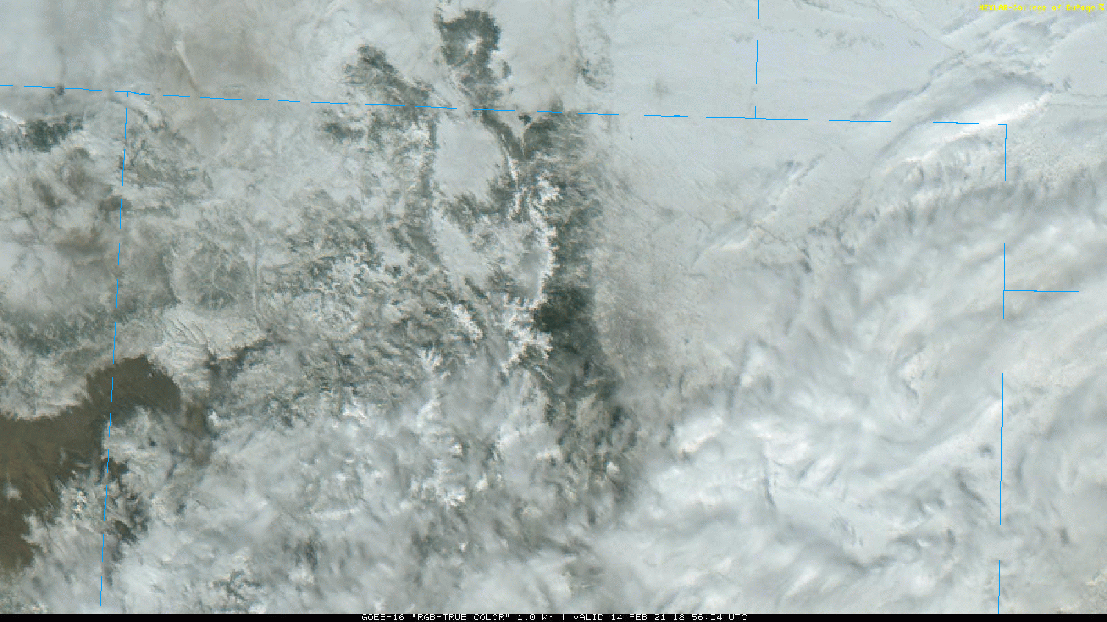
GOES-East visible satellite animation from Sunday afternoon
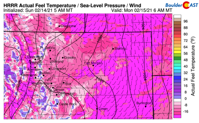
As we head into the overnight hours, temperatures will plummet again, especially in spots where clouds have cleared out more. The 1 to 3″ of new snow across the Denver Metro area isn’t ideal to maximize radiative cooling, but it should mostly do the trick. Models are indicating overnight lows of -6 to -16°F across the Metro area. One such model output, the HRRR, is shown below.
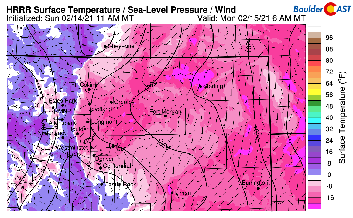
HRRR model forecast temperatures for Monday morning
Even though we’re only looking at light winds overnight, the impact those 5 to 10 MPH breezes have at these bitter cold temperatures is magnified. Areas across the Plains of eastern Colorado will see dangerous wind chills overnight of -20 to -35°F. Wind Chill Warnings are posted out that way. In the immediate Metro area, the winds will be lighter and temperatures a tad warmer in the -15 to -25°F range. The tamer Wind Chill Advisory is in effect for our area.
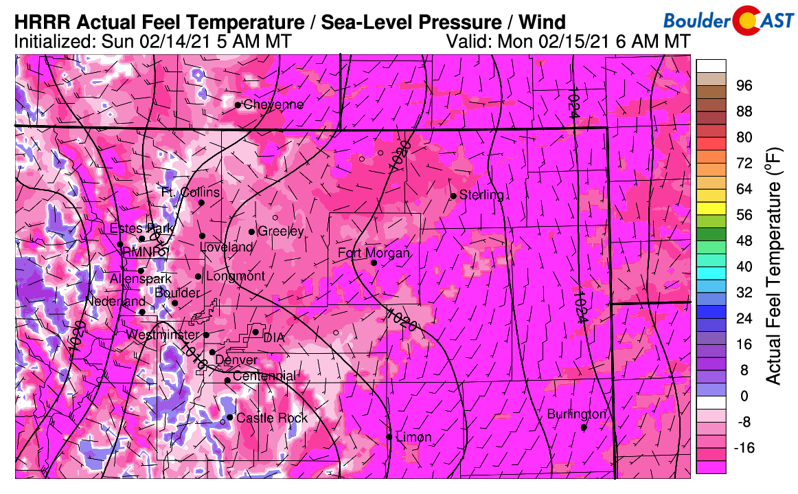
HRRR model forecast wind chills for Monday morning
Another aspect to consider is that the Arctic airmass will begin its planned retreat quickly overnight with comparatively warmer downslope flow taking over in the Foothills. For instance, while Boulder’s overnight temperature will drop through the night….just 15 miles west, Nederland at 8200 feet elevation will shift to downslope with temperatures forecast to warm-up 20 degrees through the overnight. For those of you above 6500 feet elevation, the coldest temperatures are probably already in the rear-view mirror.
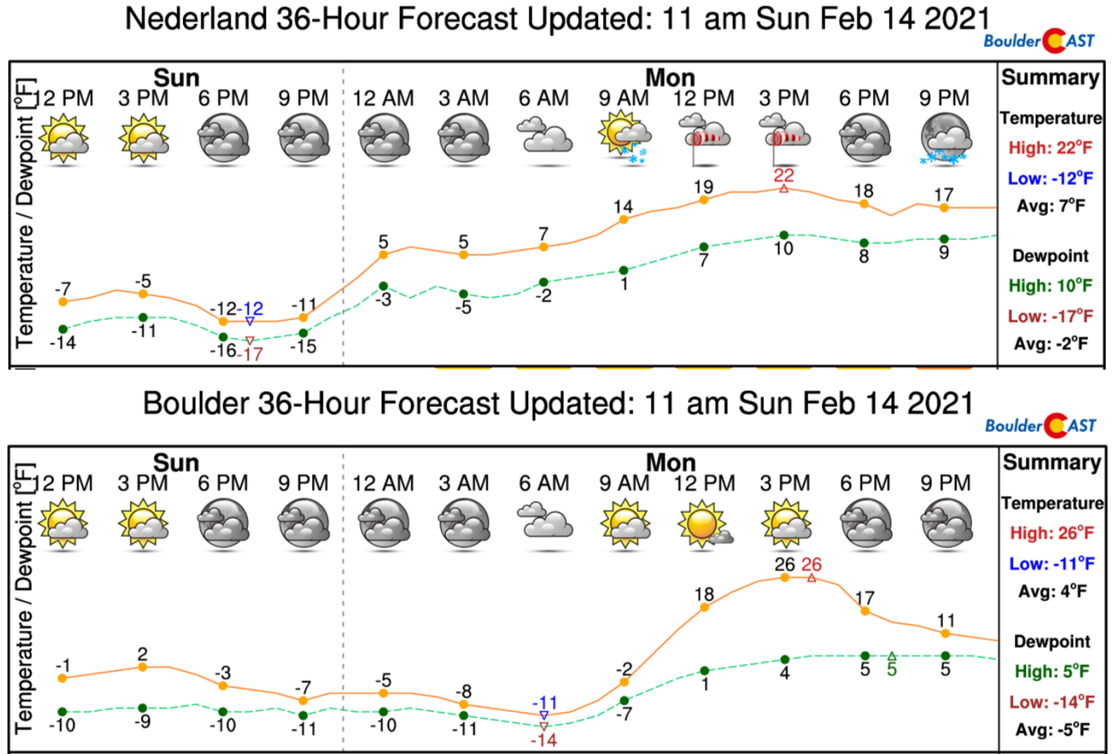
The question remains if these warmer downslope winds will funnel down into the adjacent lower elevations of the Denver Metro area and spoil what would be the coldest temperature in Boulder since 2011. We’re not expecting it, but it could happen on small scales, especially within a mile or two of the base of the Foothills. You’ll know if your area catches some of this downslope; the temperature will increase 25 to 40 degrees rather quickly!
Moderating, but still very much chilly temperatures are expected for the week ahead. We’ll talk more about this welcomed warming trend in our weekly outlook tomorrow morning. Stay toasty!
Help support BoulderCAST and save 25% with promo code FRIGID
Help support our team of Front Range weather bloggers by joining BoulderCAST Premium. We talk Boulder and Denver weather every single day. Sign up now to get access to our daily forecast discussions each morning, complete six-day skiing and hiking forecasts powered by machine learning, first-class access to all our Colorado-centric high-resolution weather graphics, bonus storm updates and much more! Or not, we just appreciate your readership!

.
Spread the word, share the BoulderCAST forecast:
.


You must be logged in to post a comment.