
After a bitter cold stretch under the fringes of the Polar Vortex, a “relative” warming trend develops this week but we still remain largely below average. By mid-week a cold front will bring the return of light snow to the area. Week’s end may turn breezy and finally near normal with potential Chinook winds developing. Let’s dig into the details.
This week’s highlights include:
- We finally say goodbye to the extremely cold Arctic air as it oozes away to our east
- The deep cold moves out to allow for slight downslope warming
- A chance of light snow returns to the forecast Tuesday and Wednesday
- Late-week the pattern may favor Chinook winds with jet stream remaining nearby
DISCLAIMER: This weekly outlook forecast is created Monday morning and covers the entire upcoming week. Accuracy will decrease as the week progresses as this post is NOT updated. To receive daily updated forecasts from our team, subscribe to BoulderCAST Premium.
“Warming” trend starts the week
What a bitter cold stretch it has been since the initial Arctic front plowed through the Front Range more than a week ago! Monday morning’s low temperatures are well below zero and are the coldest yet. On Sunday, some locations barely got above zero, while many did not.

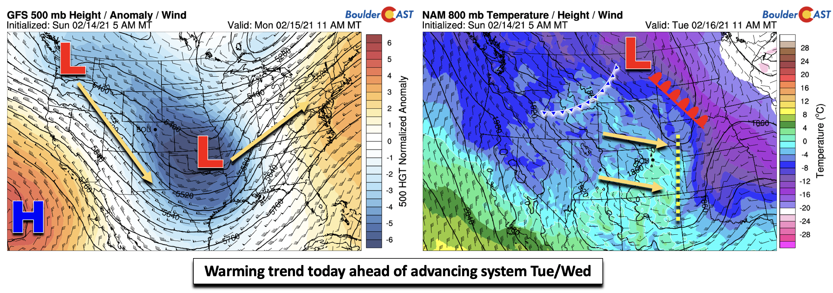
However, this epic cold snap is all about to give in. Looking at the mid-level flow pattern across the country (below left), a trough in the Midwest is bringing snow to the MO/IL and Ohio Valley regions, with rain across the southeast. Weak height rises over Colorado today and tomorrow ahead of another digging trough over Washington state will allow for weak downslope warming this afternoon and tomorrow (below right). It might not seem like an improvement, but the airmass just above the surface warms from -22°C to -10°C today, and to up to 1°C on Tuesday. While that certainly still is cold, it is a huge improvement from where we were a few days ago. The “warmth” is relative as highs Monday will only top out in the middle teens. However, that’s over quite a bit warmer than Sunday!
Chance of midweek snow with a cold front
Another cold frontal passage late Tuesday will continue our stretch of below normal temperatures through at least Thursday with highs near the lower 30’s. In Boulder, we were last above average on February 7th (54°F). This cold air is certainly not as cold as what we experienced last week (below right), but the troughy pattern over eastern Colorado on Wednesday (below left) prevents the true warmth from the Desert Southwest from penetrating into the state. The frontal passage Tuesday may lead to a very slight chance of snow showers but it will be spotty at best with likely 1″ or less of accumulation.
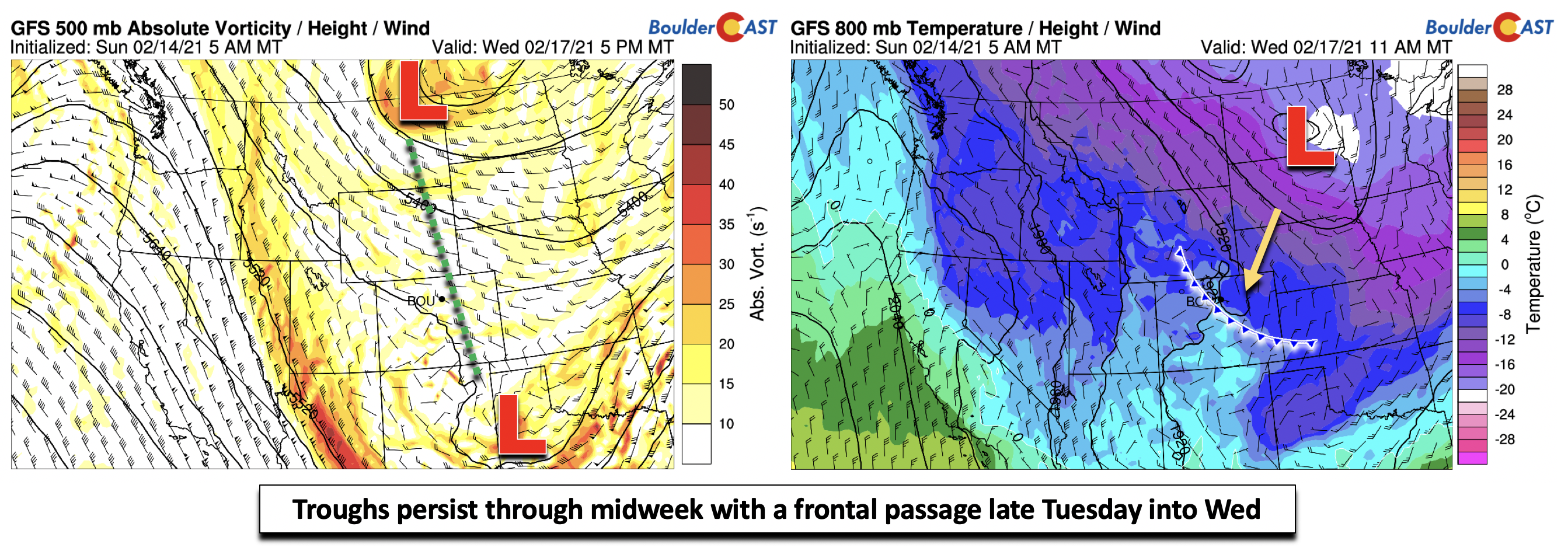
Come Wednesday afternoon/evening, the forecast guidance is hinting at the potential for some light snow (below right). This would be in concert with the surface upslope flow behind the front, as well as weak mid-level frontal forcing with high relative humidity (below left). The lift is not impressive and the trough passage is well south of our area (go figure!). However, enough of this frontal lift tied to possibly weak instability warrants a 40% chance of snow on the Front Range.
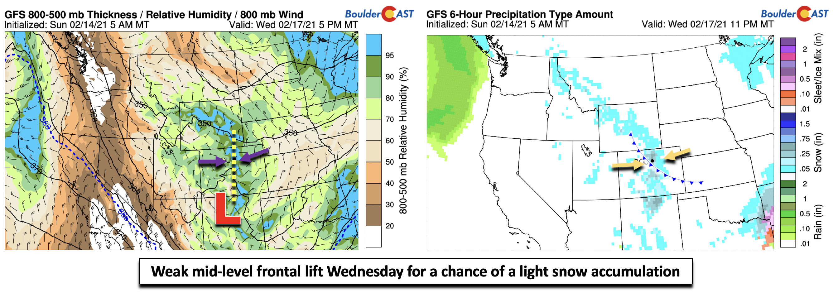
Unless the pattern changes drastically over the next day or two, Wednesday’s snow event will produce a dusting to 3″, though some models are showing the potential for a little more in the Boulder area. It bears watching but isn’t impressive by any means, consistent with the latest ensemble guidance (below) which indicates a light snow event but nothing that would offer major impacts or much moisture unfortunately. Nonetheless, as always we will be watching this system closely.

Getting back to normal late week
Friday’s forecast is sort of a mixed-bag at the moment. While it should be our warmest day of the week, there is the potential for gusty Chinook winds. The jet stream on Friday is poised to be blowing directly across the High Country from west to east (below left). That usually favors elevated chances for windy conditions on the Plains, as evident in the gusty low-level wind forecast (below right). We don’t have enough confidence to say a maximum gust potential, but from a pattern recognition standpoint, it could easily exceed 40 mph.
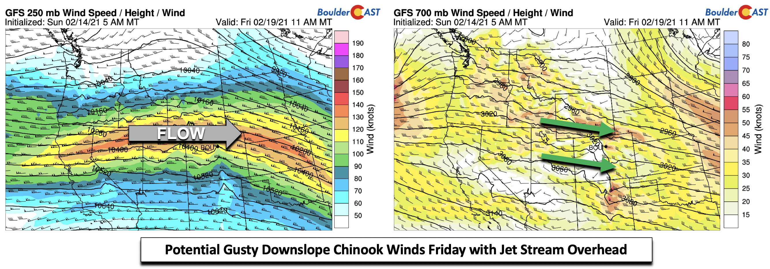
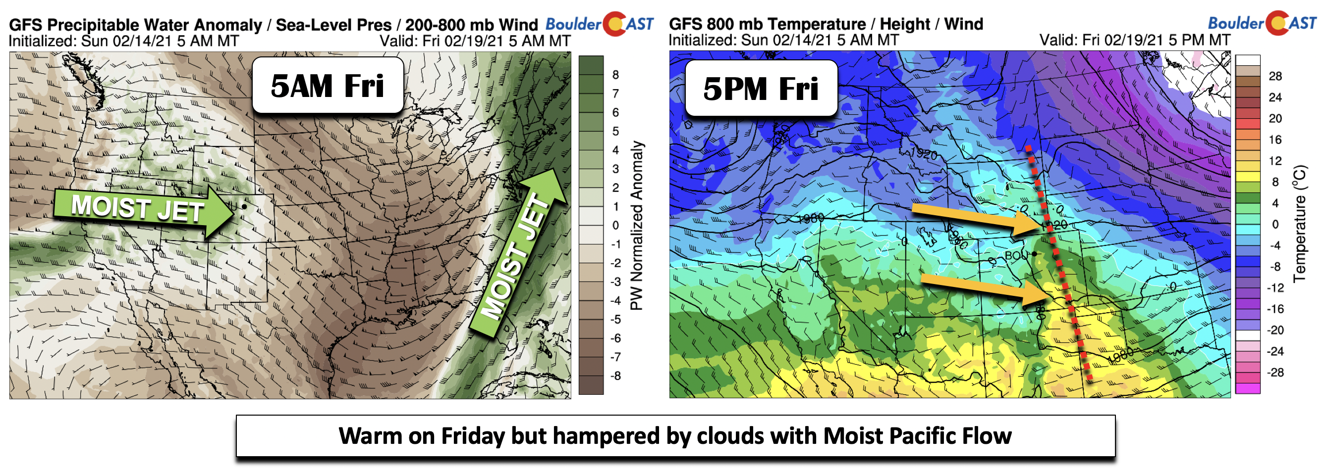
The potential gusty westerly winds on the Plains will spell out continued warmth at the surface, with the low-level airmass warming above freezing (below right). This would potentially translate to highs reaching the middle 50’s to end the week. However, with the strong jet stream overhead, a moist Pacific flow (below left) will likely lead to considerable wave clouds, hampering our warmup. Upper 40’s on Friday is a good forecast this far out, which would place us above average for February. Finally!
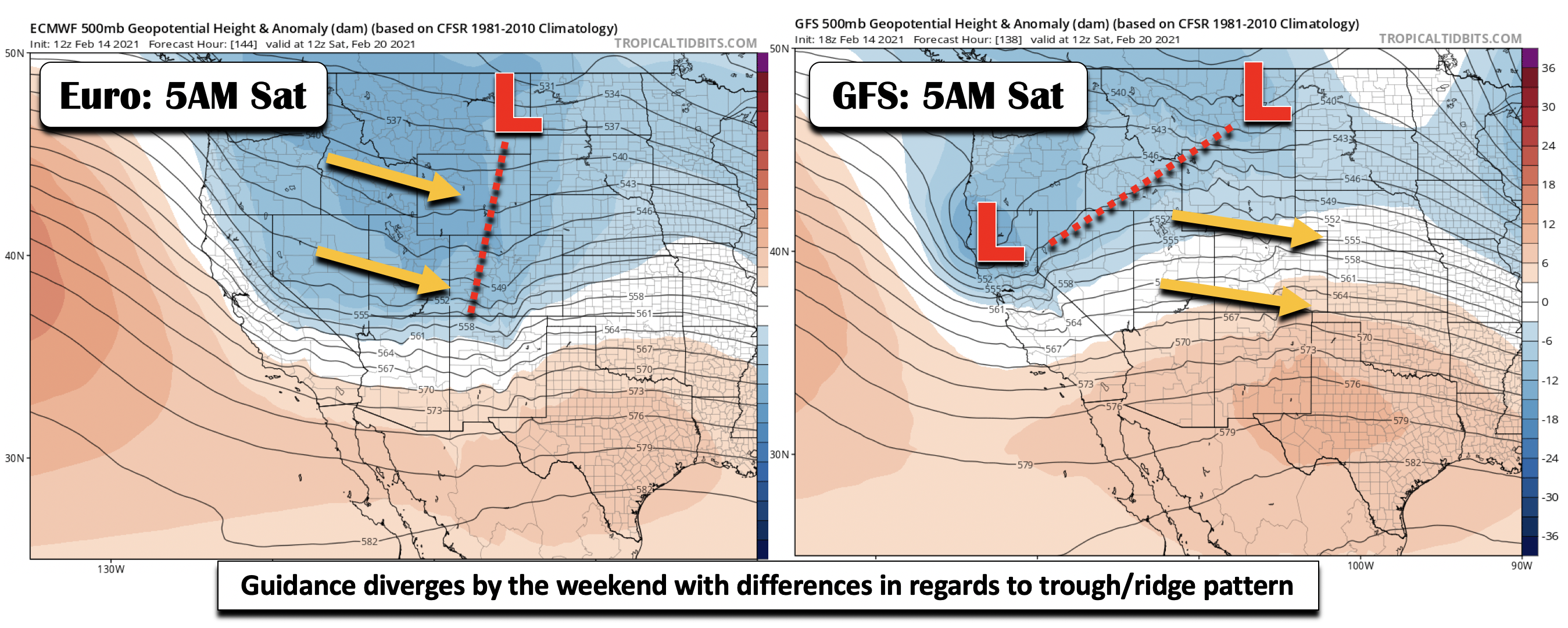
Over the weekend, the guidance diverges on the forecast. The Euro model (below left) is faster to bring a trough across Colorado, while the GFS is slower (below right). These differences translate to varying outcomes in high temperatures on Saturday and in regards to potential cloud cover. The trough passage at this point could lead to snow/rain on Saturday but the varying solutions at this point breeds low confidence.
Finally, if you happened to miss our recap of the recent disappointing snow storm, you can find that HERE. Have a great week!
Forecast Specifics:
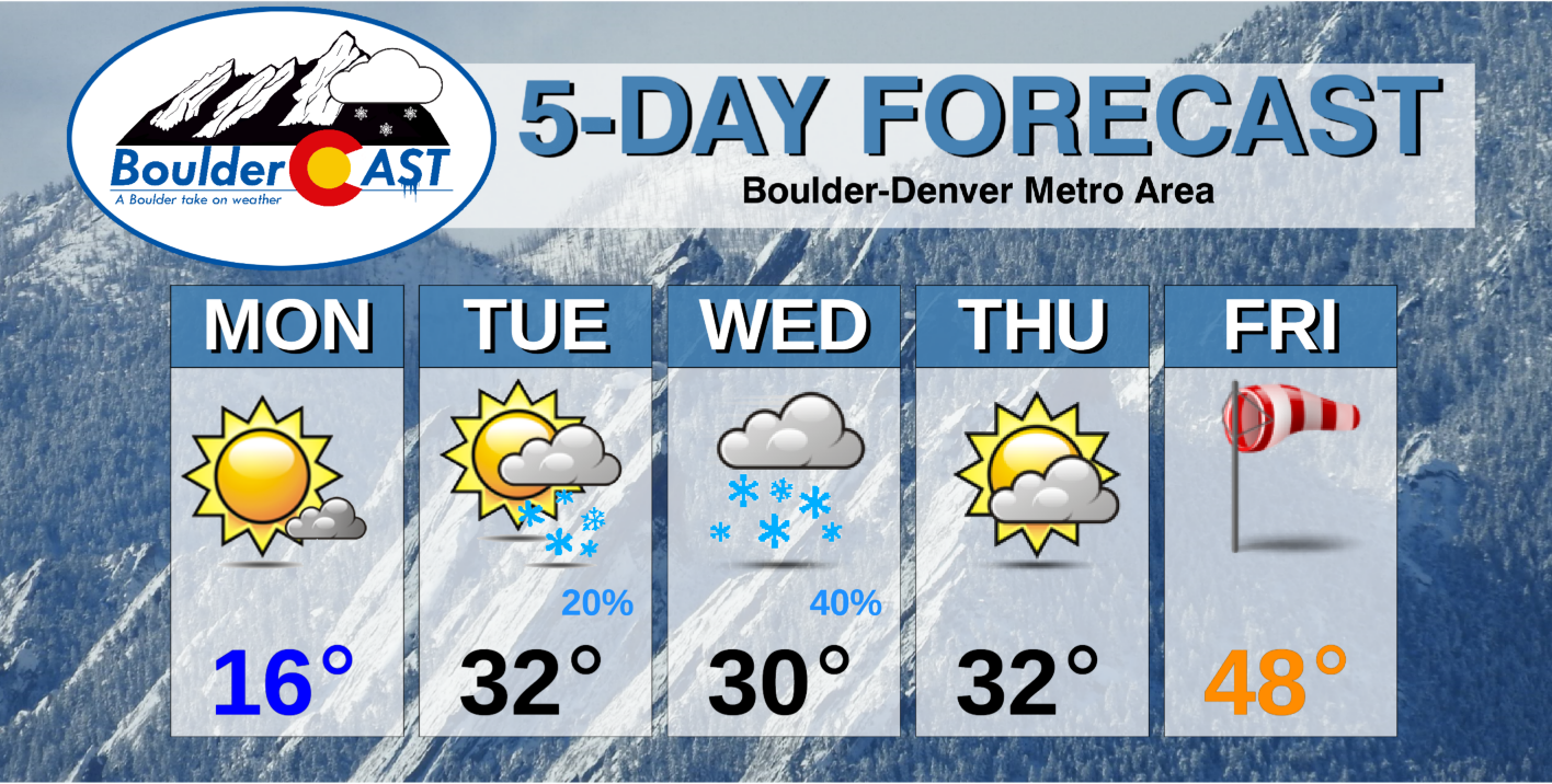
Monday: Bitter cold to start the day with lows well below zero. A few morning clouds becoming mostly sunny. Highs in the teens on the Plains but 20’s in the Foothills.
Tuesday: Partly cloudy skies with highs in the lower 30’s on the Plains and lower 30’s in the Foothills. A slight chance of snow showers in the afternoon into evening but no accumulation expected.
Wednesday: Chillier and mostly cloudy with a decent chance of light snow. A dusting up to 3″ of accumulation is possible. Highs in the lower 30’s on the Plains and middle 20’s in the Foothills.
Thursday: Morning clouds becoming more sunny through the day. Chilly with highs in the lower 30’s for the Plains and middle 20’s in the Foothills.
Friday: Partly to mostly cloudy skies, warmer and breezy with highs in the upper 40’s on the Plains and lower 40’s in the Foothills.
Weekend: Temperatures will likely be near normal, trending to below average. A slight chance of precipitation is possible over the weekend as well, but details are too unknown right now.
Mountains: The Mountains will see off and on periods of snow through the week under west-northwest flow.

Help support BoulderCAST and save 25% with promo code FRIGID (Ends 2/19/21)
Help support our team of Front Range weather bloggers by joining BoulderCAST Premium. We talk Boulder and Denver weather every single day. Sign up now to get access to our daily forecast discussions each morning, complete six-day skiing and hiking forecasts powered by machine learning, first-class access to all our Colorado-centric high-resolution weather graphics, bonus storm updates and much more! Or not, we just appreciate your readership!

.
Spread the word, share the BoulderCAST forecast!
.


You must be logged in to post a comment.