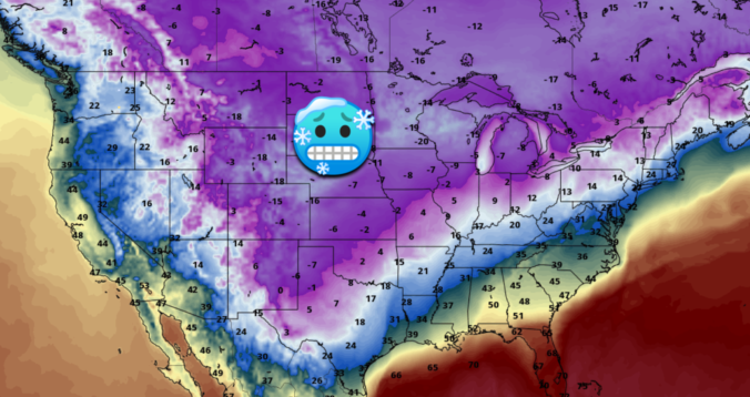
It’s certainly busy in the weather world this weekend as the coldest air in years arrives to eastern Colorado alongside several chances for light snow. The weather models have largely come into agreement regarding what will transpire in the coming days and thus our forecast confidence is growing. We discuss just how cold it will get, the timing on those snow chances and give our preliminary snowfall forecast for the region. Let’s take a look.
At a Glance:
- The coldest air in years will impact the Front Range this weekend as the Arctic blast continues
- Two storm systems and persistent shallow upslope will keep snow and gloom in the forecast daily
- The coldest day will be Sunday with highs in the single digits
- The absolute coldest temperatures should occur Monday morning, potentially reaching as low as -20°F if clouds clear out enough
- The Mountains will measure snow by the foot this weekend, while the lower elevations pick up lighter but still significant snow amounts
We’re going to discuss the bitter cold temperatures expected in the coming days first, as we believe this to be the bigger story this weekend. If you’re only interested in the snowy part of the forecast, just head to the next section where we discuss the timing and expected snowfall amounts.
HOW COLD WILL IT GET?
This week’s somewhat mild and pleasant forecast went out the window quickly with the Arctic airmass holding strong every single day this week since Monday. Daytime high temperature forecasts issued early in the week have been anywhere from 10 to 25 degrees too warm compared to what actually happened each day. This is the nature of the business with Arctic fronts and something we made crystal clear in our weekly outlook this past Monday. These scenarios have a lower predictability than most other aspects of weather. Despite how many “the weather man was wrong again!” jokes are shared in small-talk and memes around the world, each and every day we are literally predicting the future. Just keep that in mind before you click the share button on that next demoralizing meteorologist meme!
Let’s get to back to the issue at hand: the coldest stretch of weather in years is coming to the Front Range in the next few days! Seriously, we mean it. The Arctic airmass which has lingered the entire week so far will be reinforced multiple times in the coming days as the parent Arctic high pressure center shifts from southern Alberta today into Minnesota by Sunday night, which is shown below.
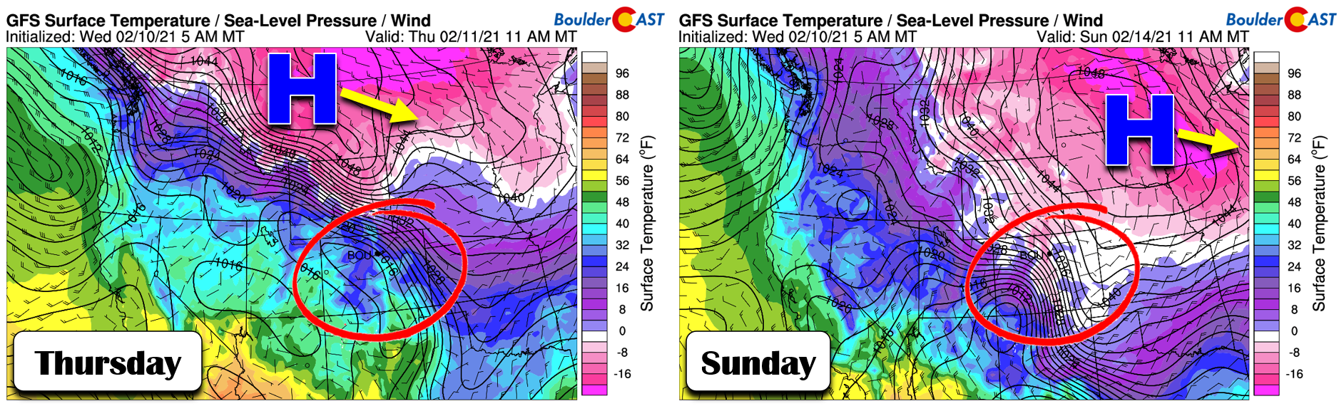
This shift will bring the coldest air southward to encompass all of eastern Colorado. In the days following, the same front will push all the way south to the 20th parallel in central Mexico!
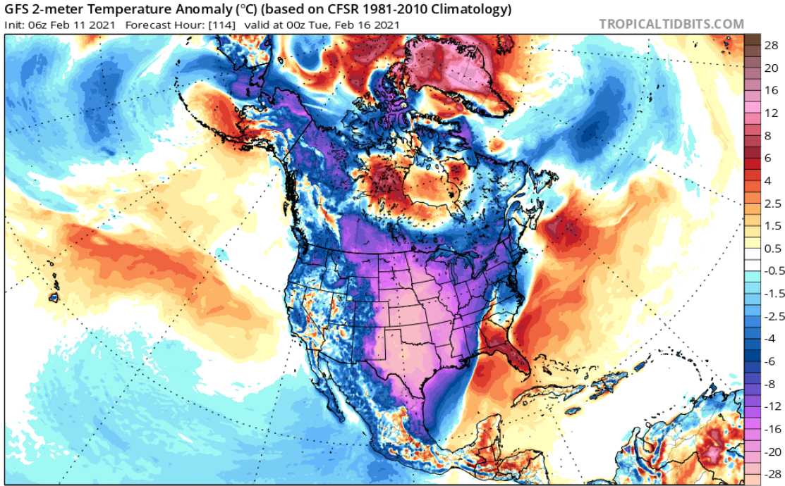
GFS forecast surface temperature anomaly for Monday evening. The extent of the cool-down stretches much further south than Colorado
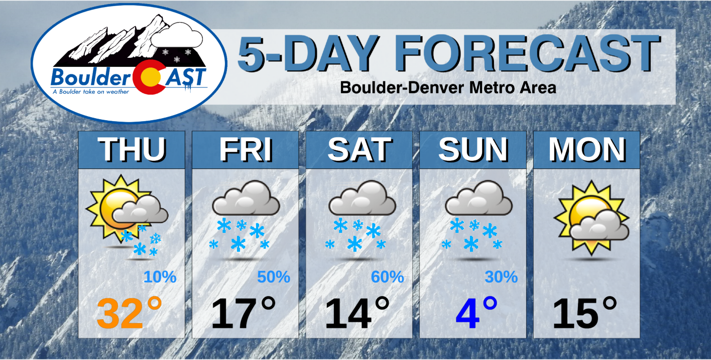
For us the cold air will come in waves, with the first Thursday evening and a second following suit Saturday evening. There won’t be much of a warm-up between the waves with extensive cloud cover and snow expected much of the time. We’re looking at highs only in the teens Friday and Saturday. That’s not too bad right? Just wait. The second wave of cold air is gearing up to make Sunday the coldest day of all with highs in the single digits, perhaps even lower single digits at that!
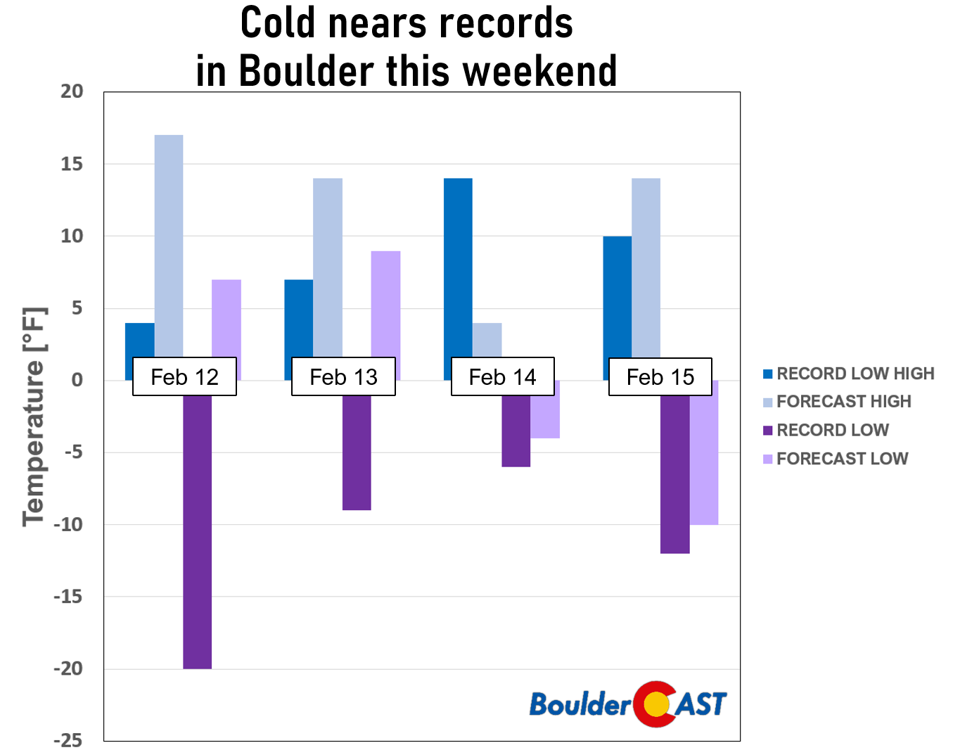
The coldest overnight period will be Sunday night when temperatures could dip into the -10 to -20°F range across the lower elevations (and even colder in the Foothills). The key factor will be cloud cover and if it will clear out quickly enough for much radiative cooling to happen. As we will discuss in the next section, there will likely be fresh snow on the ground regionwide which does boost radiative cooling if skies are able to clear. Right now it looks like the skies should become at least partly clear before sunrise Monday, potentially opening the door for new daily record lows in much of eastern Colorado. If skies stay overcast, we’ll instead probably settle around a balmy -5°F Monday morning. The potential for -20°F is there if skies do clear, however. A temperature this cold would be fairly historic in Boulder. -20°F has only been recorded about 10 times in Boulder in the last 135 years…roughly once every 13 years or so. However, most of those occurrences were front-loaded into the early 1900’s before climate change and widespread urbanization in the Front Range (see urban heat island). The last time we dipped that cold was December 22, 1990 (-24°F).
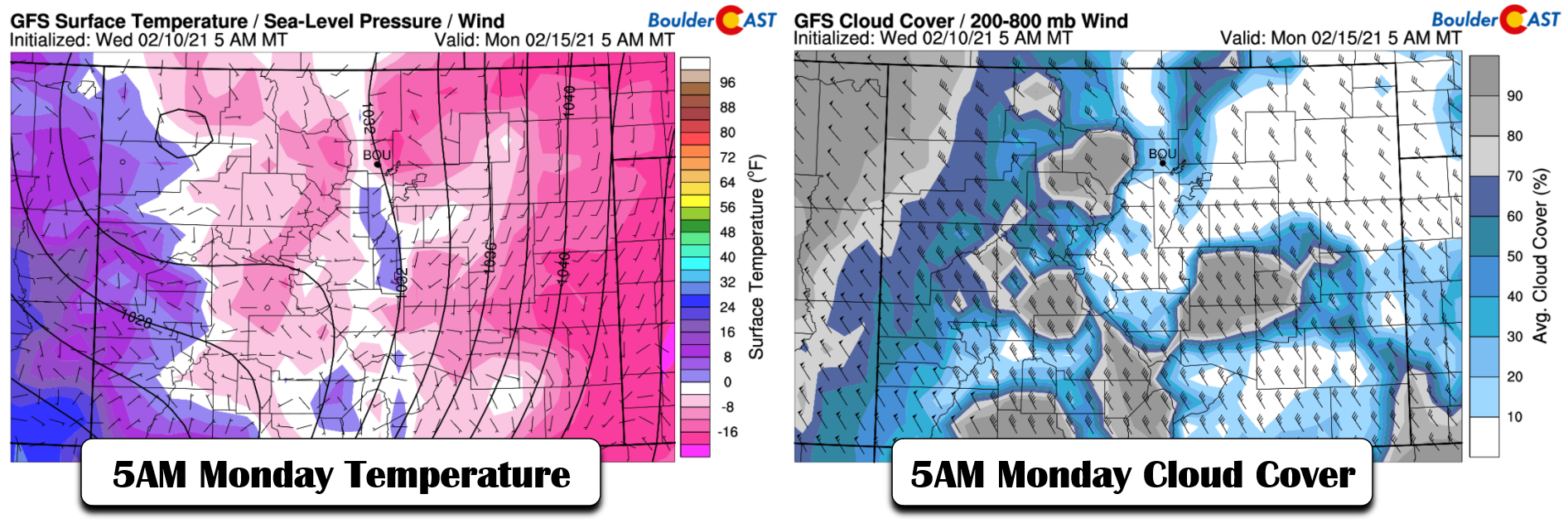
It’s important to note that there is a reason that -20°F is quite uncommon in Boulder. It’s because every scenario that gets this cold will almost always be accompanied by an expansive Arctic high in the Great Plains which will feed easterly flow (i.e. upslope) into the Boulder area. We’ve already discussed this and it will be the case this weekend as well. Boulder is very susceptible to low clouds with even weak upslope and limited moisture, which can prevent much radiative cooling. The usual layperson’s analogy is that the clouds act as a warm blanket over the surface. Finally, remember that we are forecasting a key shift in cloud cover which will happen towards the backside of two passing storm systems and is still four days out. Obviously, there is some uncertainty but we are giving you the latest.
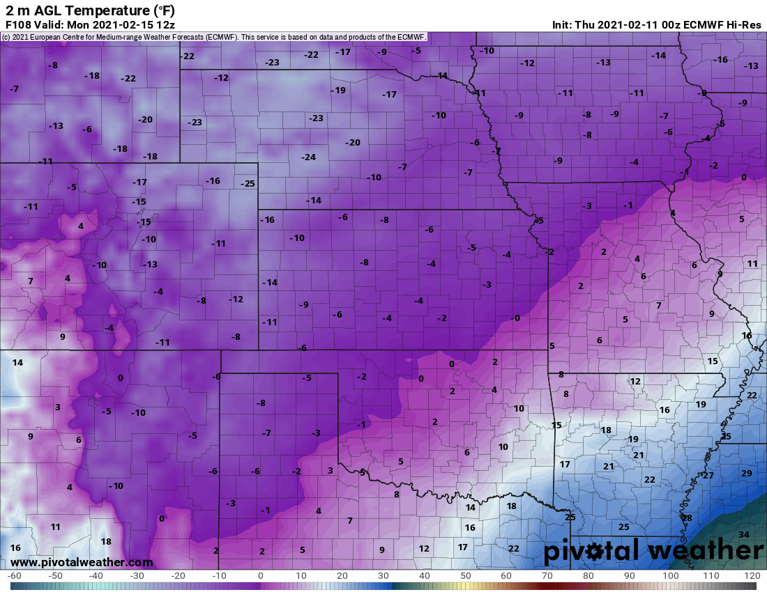
European model forecast low temperatures Monday morning
On the tail-end of things, models want to quickly warm us back up Monday afternoon into the upper 20’s as the influence of the Arctic high begins to wane in Colorado. However, typically the transition will not happen this rapidly at all and we’re expecting temperatures on Monday to warm only back into the lower to middle teens. Furthermore, depending if Boulder is able to rise above freezing this (Thursday) afternoon, we could be looking at a sub-freezing stretch of nearly 9 straight days and 200 straight hours. Just another facet of this cold snap which could be notched in the history books….
In reality, a temperature of -20°F isn’t that bad, especially since winds will be fairly light. Ironically, just today social media reminded me of a particularly frigid day nine years ago from one of my trips to central Greenland during grad school. Yes, that is the actual wind chill. So you see, it’s all about perspective!
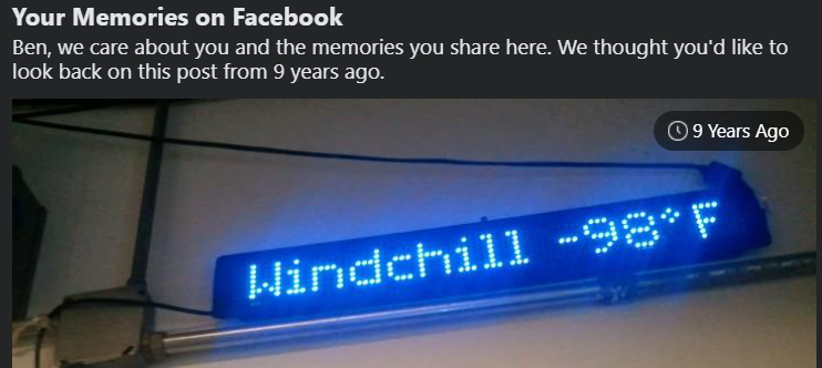
The air temperature at Summit, Greenland often dips below -65°F with wind chills below -100°F not uncommon.
HOW MUCH SNOW WILL ACCOMPANY THE BITTER COLD?
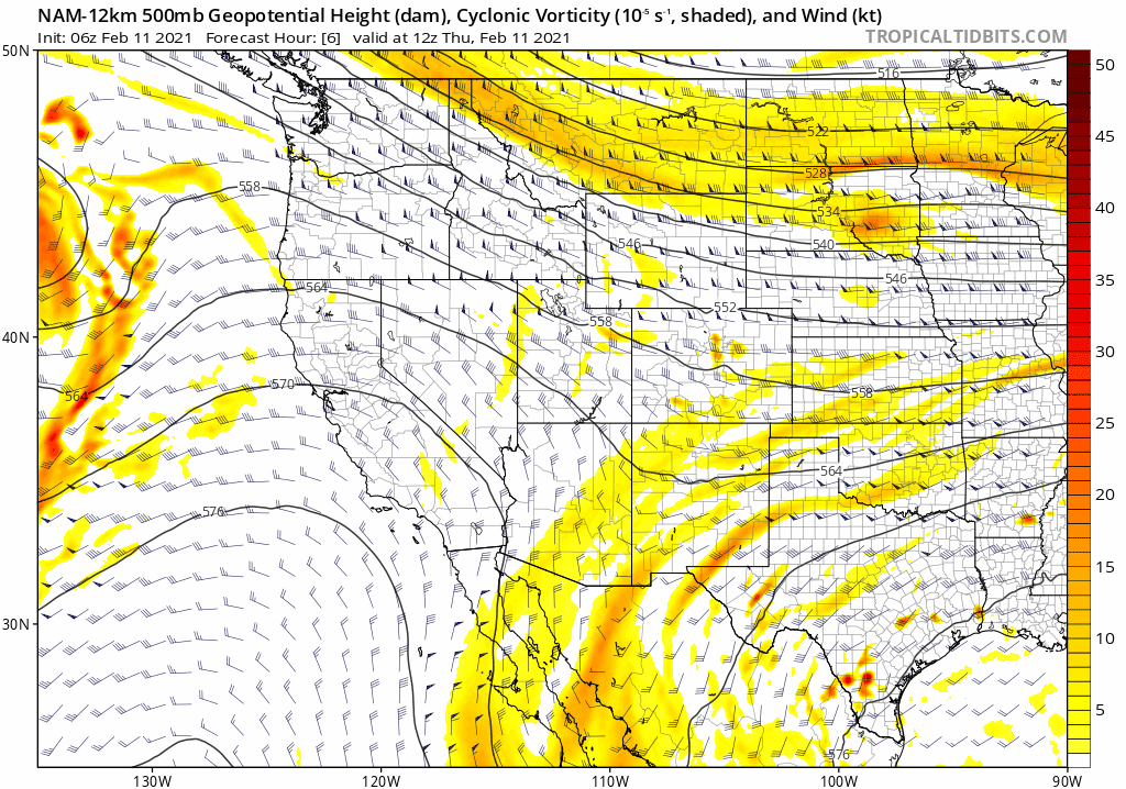
The much-needed snowfall is definitely taking a back-seat to the extreme cold over the weekend, but there still is a lot to consider. It will be the tale of two airmasses this weekend as the Mountains are under the gun from a warmer and more moist Pacific airmass while the Plains shiver in a drier polar wonderland. All the while the Arctic air remains fully entrenched in eastern Colorado, two completely separate Pacific storm systems will come ashore and move across the southern Rockies. These features are visible in the 500mb forecast animation below which covers Thursday through Sunday. Notice how the first system is more compact and dives way south into Mexico. The second system more directly targets southern Colorado and is stronger.
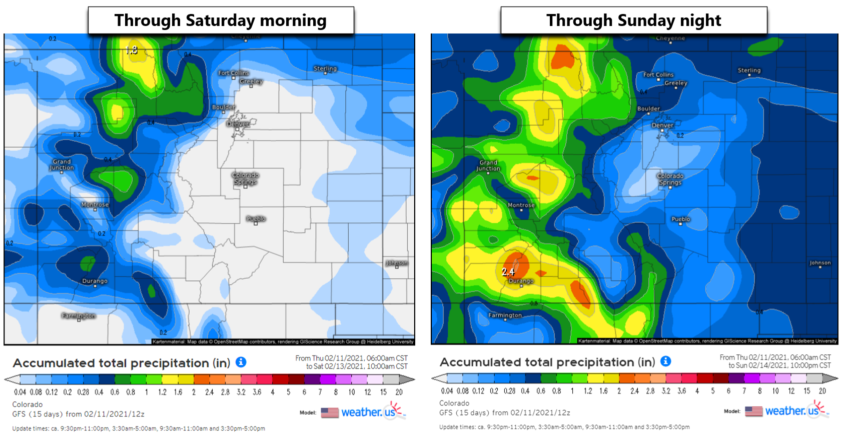
As the reinforcing cold air arrives from the northeast, the Arctic airmass will deepen considerably and allow for the development of widespread light snow and flurries Thursday night into Friday night as weak upslope helps to wring the moisture out of this bitter cold airmass. This period of light snow should ultimately amount to 1″ or less of fluffy snow in most areas through Friday night. We should see some drying on Saturday but with still overcast skies and a few flurries hanging around. Little to no additional accumulation is expected during the day Saturday.
The main event, if you want to call it that, will come with the second stronger storm Saturday night. Pacific moisture will be streaming in aloft and over-running the Arctic airmass. This injection of moisture and lift from the developing closed-low near the Four Corners will fuel snow for much of Colorado Saturday night into Sunday morning. The west-southwest flow will favor the central and southern Mountains slightly for big accumulations, but really the entire state will do great through the end of the week and weekend.
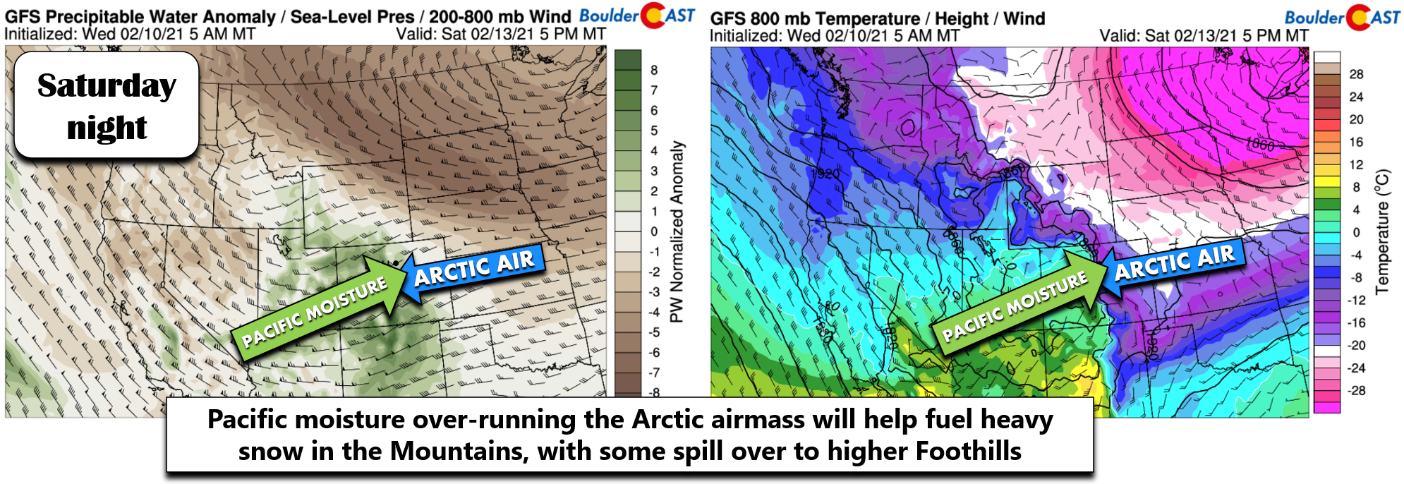
Over-running scenarios are typically not handled well by the models with a tendency toward underestimation. There will be quite a dumping near and west of the Divide throughout the state. This is great news with snowpack definitely needing a mid-winter boost to get back on-track! Additionally, there will be some spill-over dropping into the highest Foothills of Boulder/Larimer Counties which too could pick up some impressive snow.
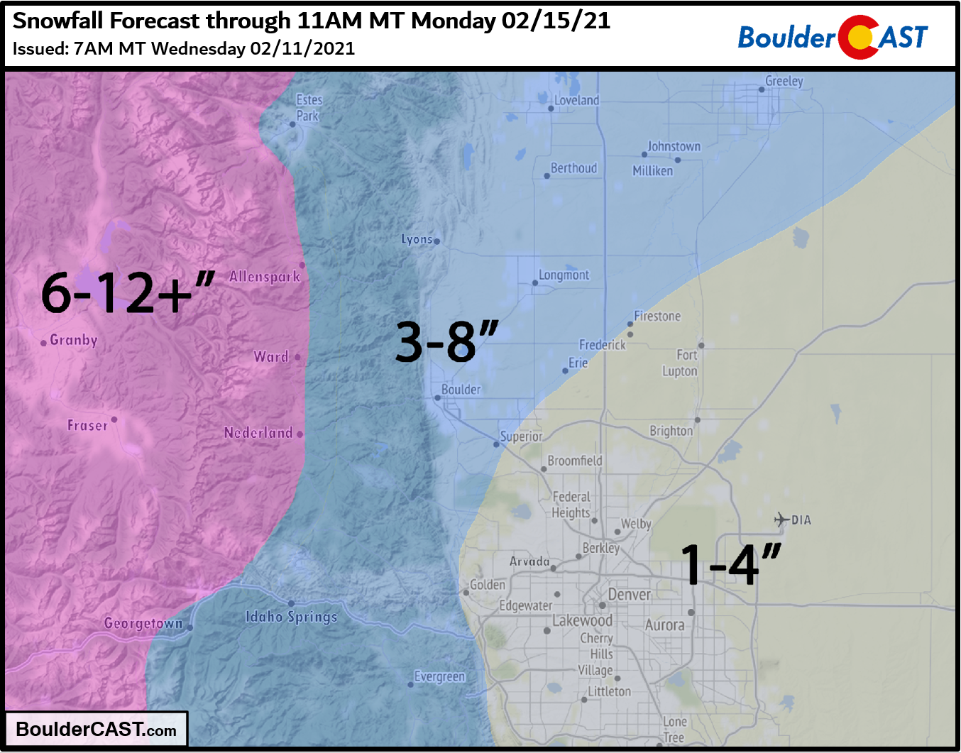
Across the lower elevations, we’re looking at fairly minimal accumulation potential initially…anywhere from a light dusting up to 1″ by Saturday morning. The main event Saturday night into Sunday is shaping up to a bigger deal for the Denver Metro area. We’re looking at about 0.25″ of moisture with that second system in Denver and perhaps double that in the Foothills of Boulder and Larimer Counties. The reason for this northwest bias in moisture across the region is the low-level wind direction. It will be southeasterly Saturday evening for a good while before turning more northeasterly overnight. SE winds favor Larimer County. The second wave of snow should produce anywhere from 2-4″ in Denver and 3-7″ from Boulder north and west.
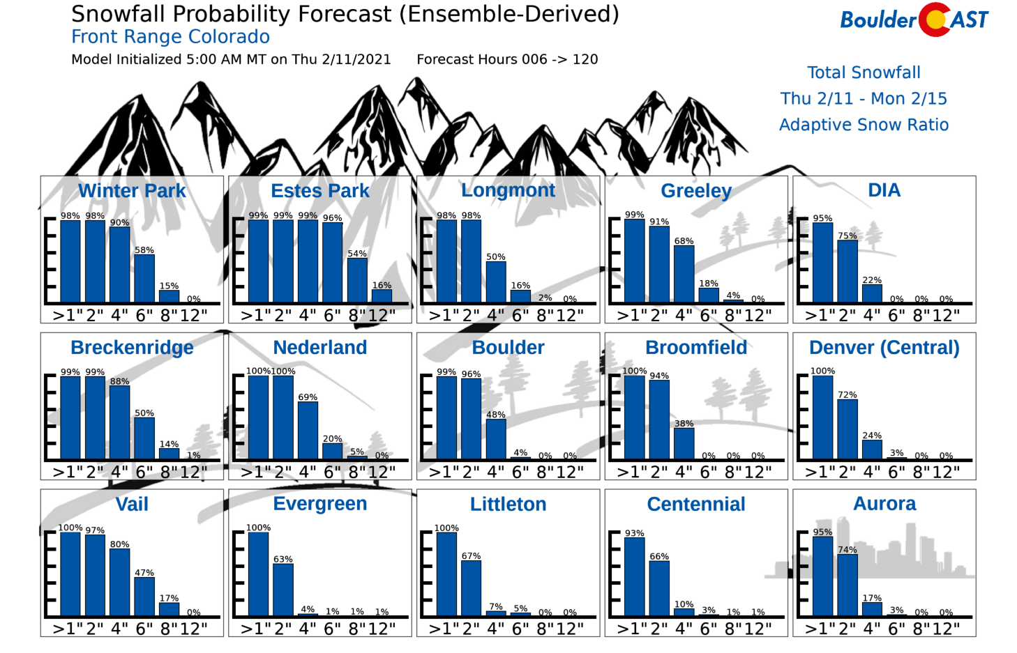
Our Snowfall Probabilities show the chance of snow is highest west and north as well.
Our PRELIMINARY snowfall forecast for EVERYTHING falling Thursday night through Sunday night is shown below. Given the projected temperatures, any snow that falls will have little trouble making for slick and snow-packed roadways. Melting agents used by road crews just don’t work at temperatures this cold, so it could get quite messy all around, especially in the Mountains. For these travel impacts alone, it’s probable that Winter Weather Advisories will be posted late Saturday into Sunday for much of the area.
Our five day forecast remains entirely below freezing and is one of the coldest we’ve ever issued since BoulderCAST’s founding in 2015.
That’s all for now. We’ll post another update or two leading up the main event of snow Saturday night and then the encore of the coldest temperatures Monday morning. Make sure you are subscribed and following us on Facebook and Twitter. Be safe and good luck staying warm!
Help support BoulderCAST and save 25% with promo code FRIGID
Help support our team of Front Range weather bloggers by joining BoulderCAST Premium. We talk Boulder and Denver weather every single day. Sign up now to get access to our daily forecast discussions each morning, complete six-day skiing and hiking forecasts powered by machine learning, first-class access to all our Colorado-centric high-resolution weather graphics, bonus storm updates and much more! Or not, we just appreciate your readership!
.
Spread the word, share the BoulderCAST forecast:
.


You must be logged in to post a comment.