This week’s snow event, while certainly welcomed, is not nearly enough not help the ongoing extreme drought across the entire state of Colorado. With a dry stretch shaping up through the weekend ahead, Boulder will most likely polish off January with its 7th consecutive month of below normal precipitation. We recap the recent “snowstorm”, discuss the current state of the drought, update you on the evolving La Niña, and provide our prediction for what lies ahead the rest of winter.
At a Glance:
- This week’s light snow event produced generally 1 to 3 inches regionwide, right in-line with expectations
- This was the 8th straight “snowstorm” that generated less than 4 inches of snow in Boulder
- La Niña is forecast to continue through the rest of our snow season, and possibly into next winter
- February through April will likely continue the dry (and warm) trend across the area
- The table is set for another devastating fire season in Colorado this summer and autumn with extreme drought running rampid and no relief in sight
Help support our team of Front Range weather bloggers by joining BoulderCAST Premium. We talk Boulder and Denver weather every single day. Sign up now to get access to our daily forecast discussions each morning, complete six-day skiing and hiking forecasts powered by machine learning, first-class access to all our Colorado-centric high-resolution weather graphics, bonus storm updates and much more! Or not, we just appreciate your readership!

Is two inches considered a snowstorm? This year it is…
Another week, another tiny snowstorm for Front Range Colorado. A small amount of snow fell Monday evening and night mainly south and west of Denver. However, a bulk of the more widespread stuff with this storm came in a “second wave” during the day Tuesday when temperatures were bitterly cold in the lower 20’s across the Metro area. The timeline of weather observations below is from our location in north Boulder. Very light snow was reported for more than twelve straight hours. There were a few brief bursts of more moderate snow with dendrites here and there, but overall this was strictly a light snowfall event, which was well advertised by the models and in our forecast.
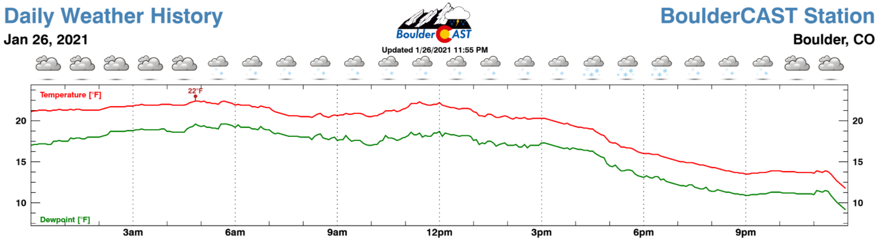
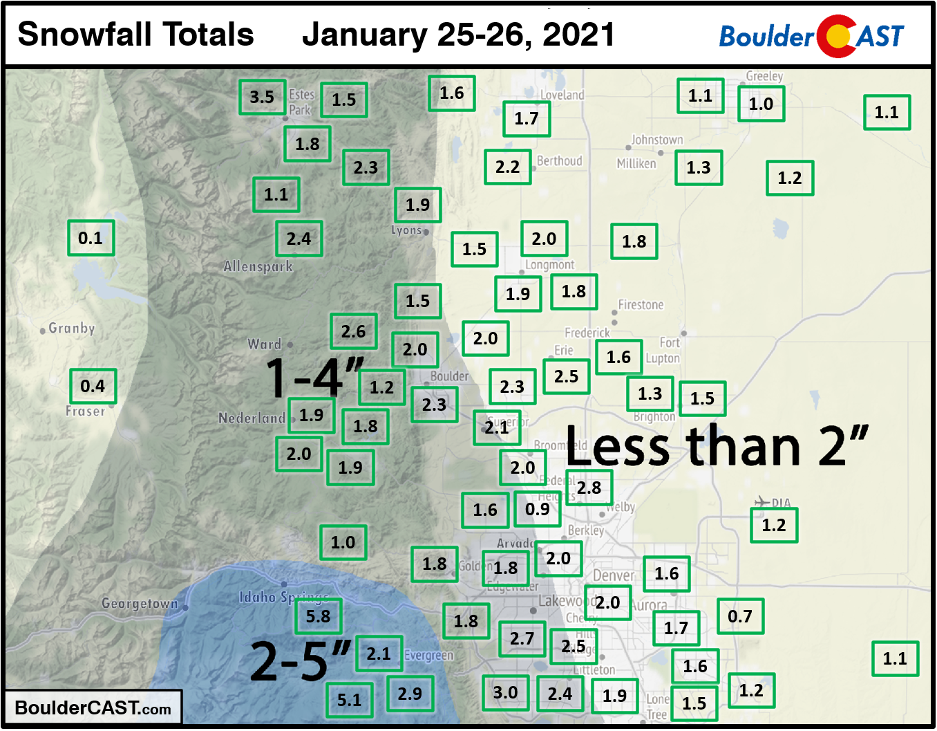
The official snowfall report in Boulder for this recent event was 2.3″. This is compared to 1.2″ in Denver at DIA. Most locations across the region picked up anywhere from 1 to 3″ of new snow, though totals near 5″ were observed in the higher Foothills of Jefferson County. Shown below is our snowfall forecast map issued Monday morning with actual storm totals overlaid in boxes. Green boxes indicate that our forecast verified to within one inch of the observed snowfall. Red did not (there are no red).
We should all be used to these petite snowstorms by now. This week’s event marks the 8th consecutive one that produced less than 4″ in Boulder.
- Jan 25-26: 2.3″
- Jan 9-10: 3.8″
- Dec 28-29: 1.1″
- Dec 15: 1.1″
- Dec 13: 0.9″
- Dec 11: 2.7″
- Nov 24: 3.9″
- Nov 9-10: 3.6″
The last “real” snowstorm we had was all the way back in late October. If you recall, that particular snowstorm brought more than a foot of snow to Boulder, the earliest ever single-digit temperature to the city, and dumped enough snow to effectively maim the raging wildfires in the Mountains.
Visit our 2020-2021 Winter Snow Summary
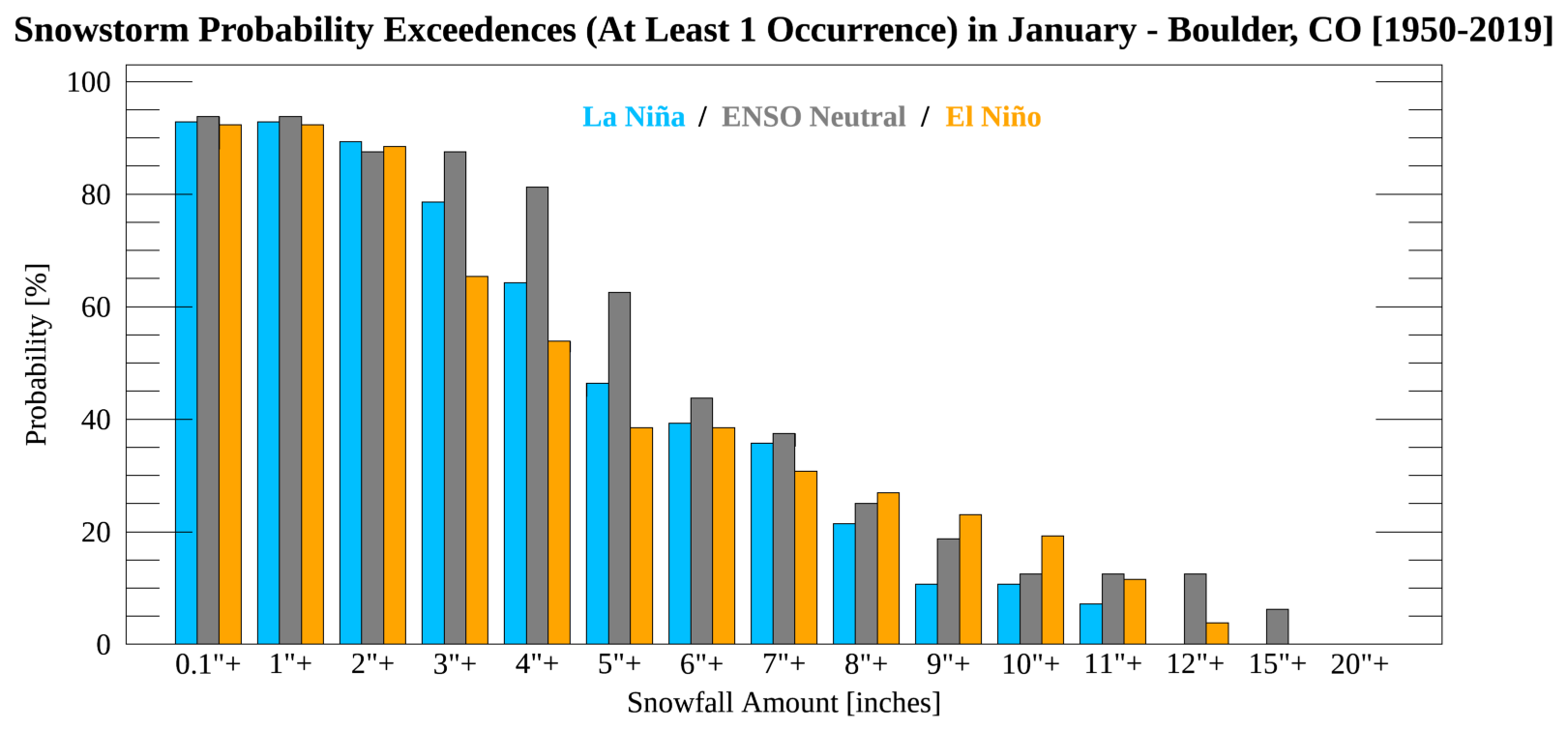
Is there anything more “La Niña-esque” than a tiny snowstorm? Not really. There is only about a 65% chance for a snowstorm greater than 4″ to occur in Boulder during any given La Niña January. With the month coming to a likely dry conclusion, January 2021 should help to lower that probability further.
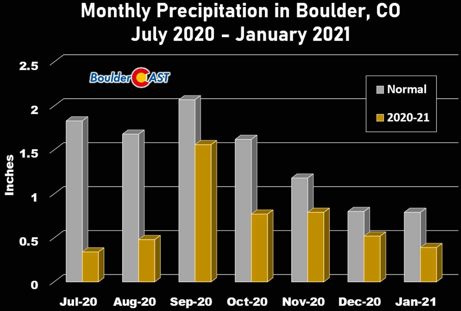
The dry get drier
For January so far, Boulder has recorded just 0.40″ of precipitation. This month is typically our driest of the year, but even what we have seen is less than two-thirds of normal. If the dry rest of January pans out as we expect, this will go down as Boulder’s 7th straight month of below normal precipitation.
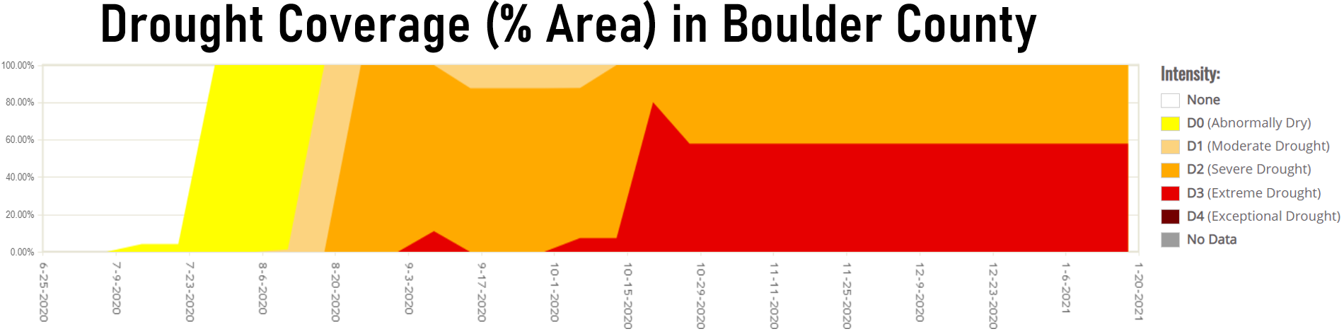
It should come as no surprise that drought has overtaken the area during this lengthy period of parched weather. 100% of Boulder County has been in drought since mid-August, with now more than 50% of the county in extreme drought.
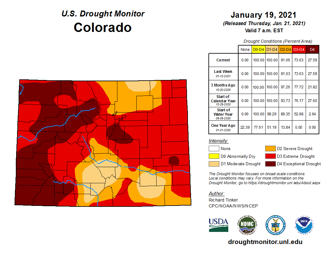
Statewide, the situation is even more dire with a huge portion of the Western Slope and Palmer Divide experiencing “Exceptional Drought”, the worst classification that can be issued by the United States Drought Monitor. These mountainous areas are unfortunately also the most flammable which frighteningly doesn’t bode well for the upcoming fire season. Could Colorado’s 2021 fire season really top the record-shattering one we just endured in 2020? It certainly seems that way. The stage is clearly already set.
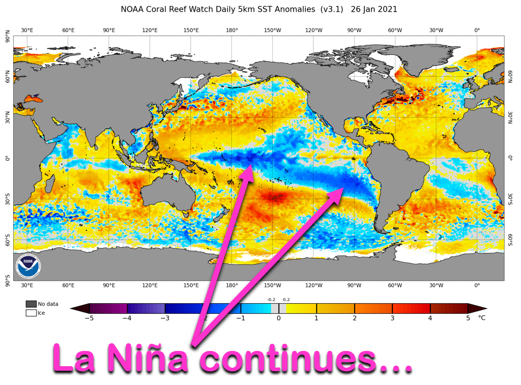
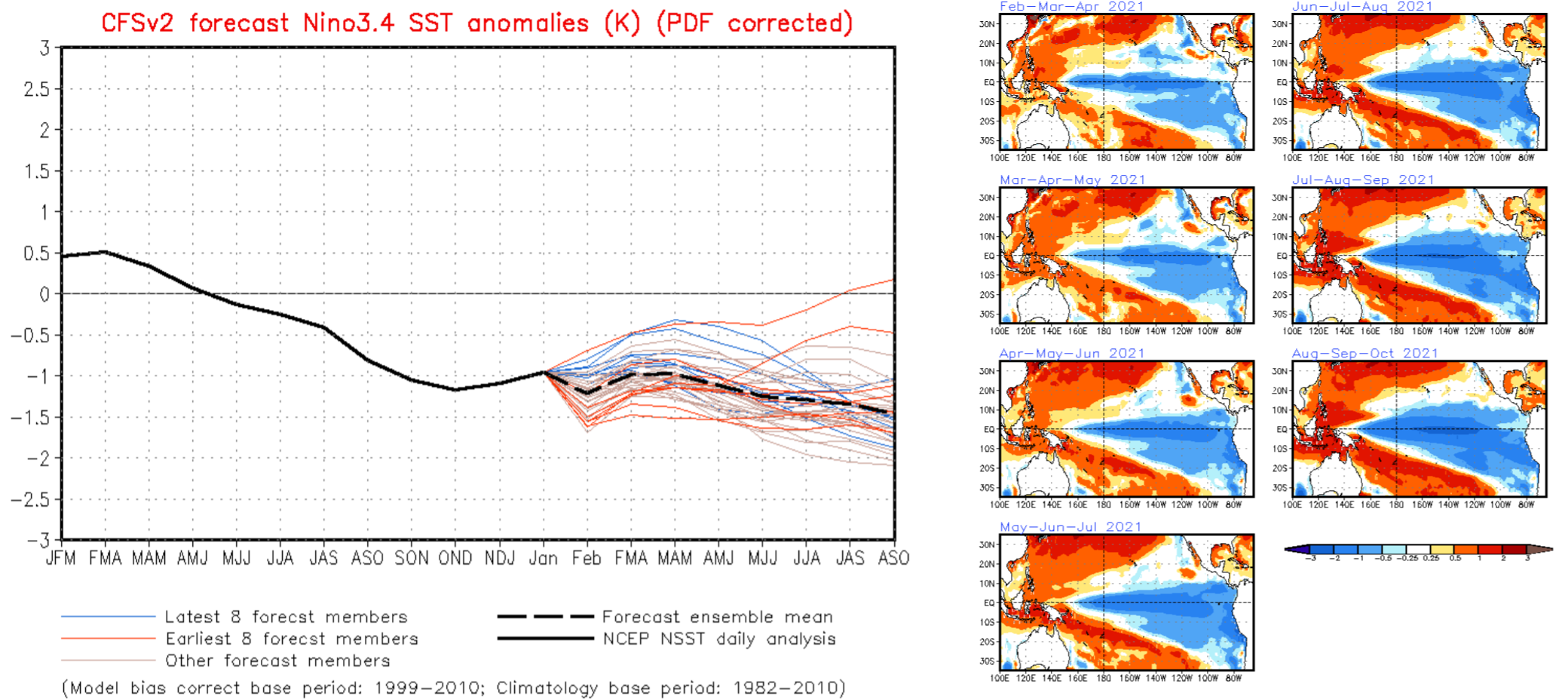
La Niña continues to rage across the Pacific Ocean with significant cold sea surface temperature anomalies observed right now along the Equator and off the South American coast.
The consensus from the climate forecasting community has La Niña continuing at least into April with some chance that it could weaken back to ENSO-Neutral conditions by late spring. However, the most likely scenario has La Niña persisting throughout 2021 and into next winter. The forecast below is from just one climate model’s ensemble.
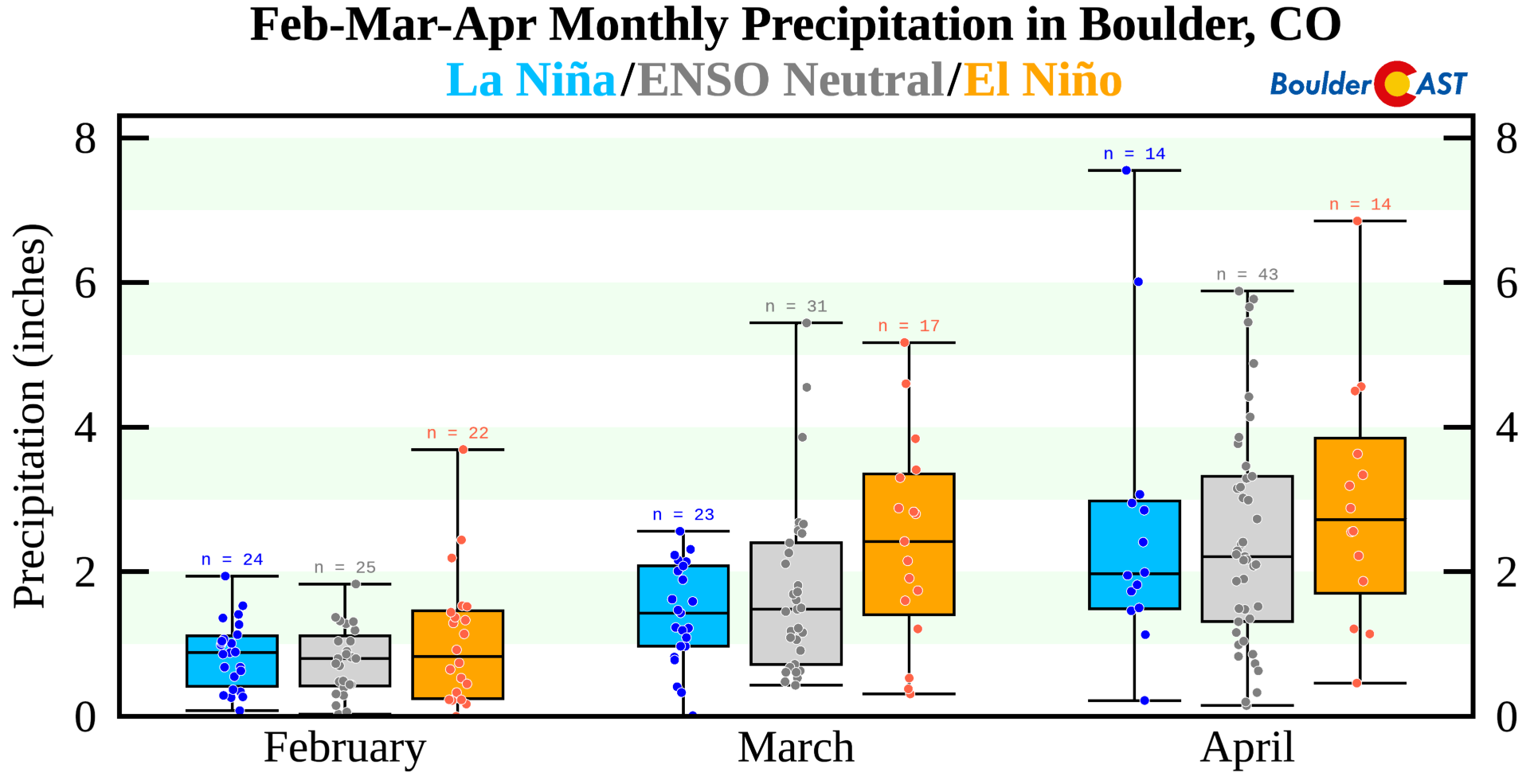
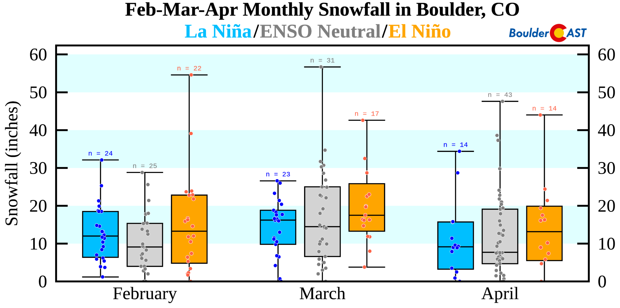
With La Niña set to drag out for at least the next three months, this does give us some insight into how much precipitation we might see the rest of winter. While there isn’t really a notable dry signal during La Niña Februaries in Boulder, March and April are clearly another story.
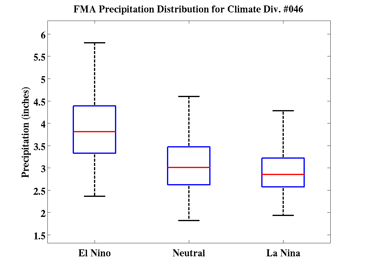
The same is also true for the broader region, not just Boulder. We see a similar dry signal when looking generally at Climate Division #46, which is basically the entire South Platte River Basin and all of northeast Colorado.
In case you were wondering (we know you were!), this drier trend translates over to less snowfall as well in Boulder during La Niña years in the months of February through April, at least compared to El Niño. ENSO-Neutral conditions surprisingly offer up the least amount of snow for Boulder.
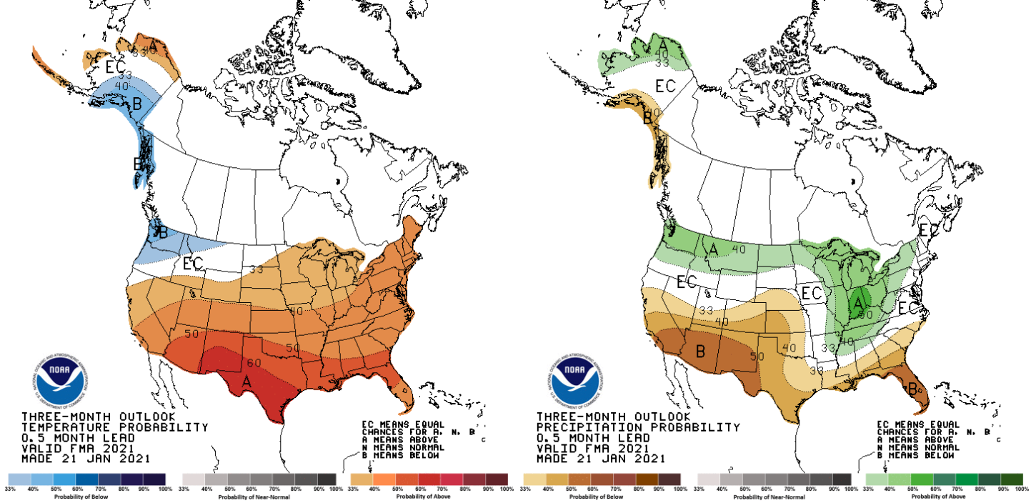
The Climate Prediction Center is on the same page we are. They are also predicting elevated chances for drier (and warmer) than normal conditions for most of Colorado over the next three months.
Ski resorts have already been decimated by COVID this year. Combining this with a lack of powder days, this has kept much of their customer-base away. Most of the skiers we know have only been out one or two times this winter (or not at all), and haven’t really enjoyed those occasions either. With the current look of things, it doesn’t seem like the situation will get much better in the coming months either.
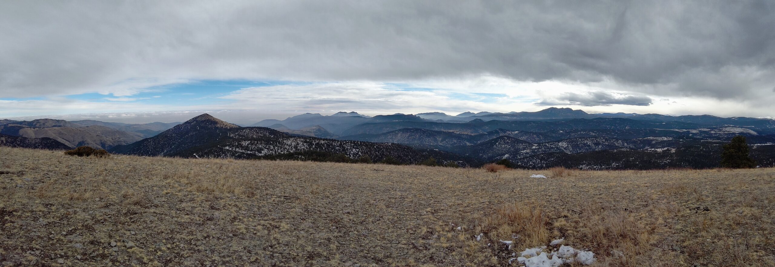
The view from the Foothills west of Boulder on January 24, 2021. Where’s the snow?
That’s all for now. If you’re not a Premium member, you likely won’t be hearing from us until early next week. However, if Mother Nature serves up what she’s cooking, we should have more snow to talk about then. Be sure to subscribe to get email notifications of our new posts and winter weather updates. Have a great rest of the week!
Get BoulderCAST weather updates delivered to your inbox!
We respect your privacy. You can unsubscribe at any time.
Help support our team of Front Range weather bloggers by joining BoulderCASTPremium. We talk Boulder and Denver weather every single day. Sign up now to get access to our daily forecast discussions each morning, complete six-day skiing and hiking forecasts powered by machine learning, first-class access to all our Colorado-centric high-resolution weather graphics, bonus storm updates and much more! Or not, we just appreciate your readership!
.
Spread the word, share this BoulderCAST post:
.


You must be logged in to post a comment.