Winter weather returns to the entire Front Range Monday and Tuesday with light snow on the table for the area. We discuss factors contributing to the early week snow and provide our snowfall forecast map. By mid-week, the pattern will shift abruptly and we could be talking 60 degrees come Friday. Read on for our complete outlook of this week’s weather.
This week’s highlights include:
- A broad but weak storm system will move from California through the Four Corners early in the week
- Light, intermittent snow is expected Monday and Tuesday across the Front Range with minor accumulations
- Highs will be very cold…near freezing Monday and in the 20’s Tuesday
- Dry weather returns Wednesday through Friday with temperatures trending upward
DISCLAIMER: This weekly outlook forecast is created Monday morning and covers the entire upcoming week. Accuracy will decrease as the week progresses as this post is NOT updated. To receive daily updated forecasts from our team, subscribe to BoulderCAST Premium.

Light snow Monday AND Tuesday
Unsettled weather was present all weekend long across the state, and this trend will continue into Tuesday night. Up until now, the snow has been piling up only in the Mountains with just a trace to 0.1″ reported east of the Continental Divide over the weekend. The San Juans of southern Colorado got hit the hardest over the last few days with two to three feet of new snow being reported at Silverton, Wolf Creek and Purgatory ski resorts.
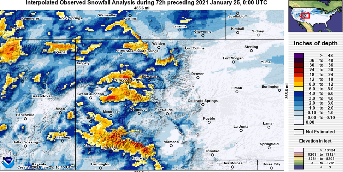
72-hour snowfall totals ending at 5PM Sunday. Not that this map does not include the heavy snow that fell in southern Colorado mountains Sunday night
Closer to home, the situation is much less wintery. Some of our team spent time in the Foothills west of Boulder yesterday. It is certainly concerning to see how little snow there is up there right now. Seriously…it’s late January and this is what it looks like….
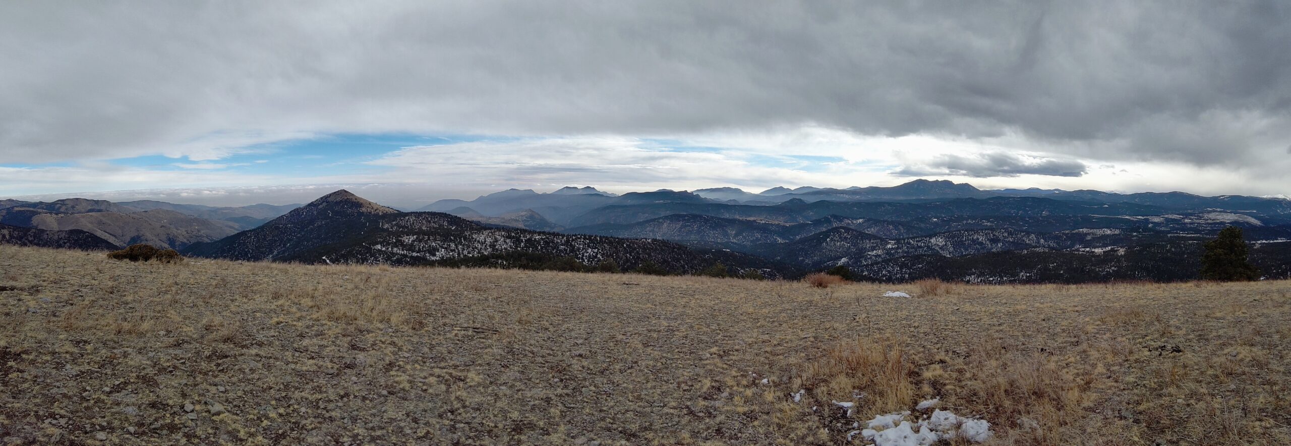
The view from 9100 feet in western Boulder County on Sunday (1/24/21)
In what has been a veritable trend so far in 2021, another southern-track low pressure system will begin to spread snow into our area through the day on Monday and into Tuesday. A look back Earthward from the GOES-East weather satellite this morning shows two low pressure systems spinning across the West. Our incoming storm is currently located in California near the Bay Area.
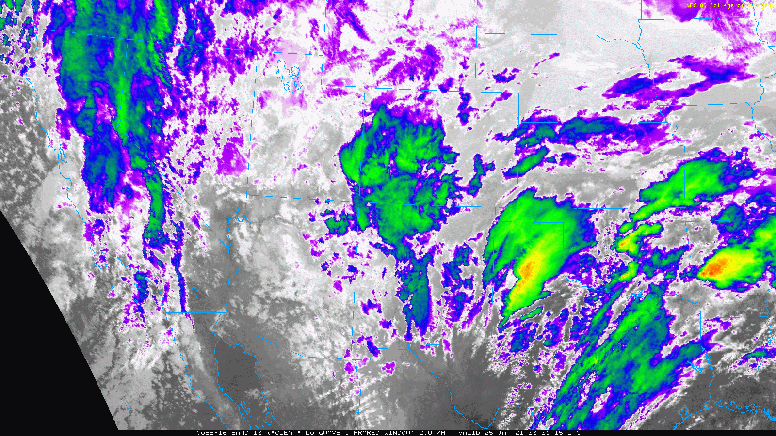
GOES-East infrared satellite animation from Monday morning
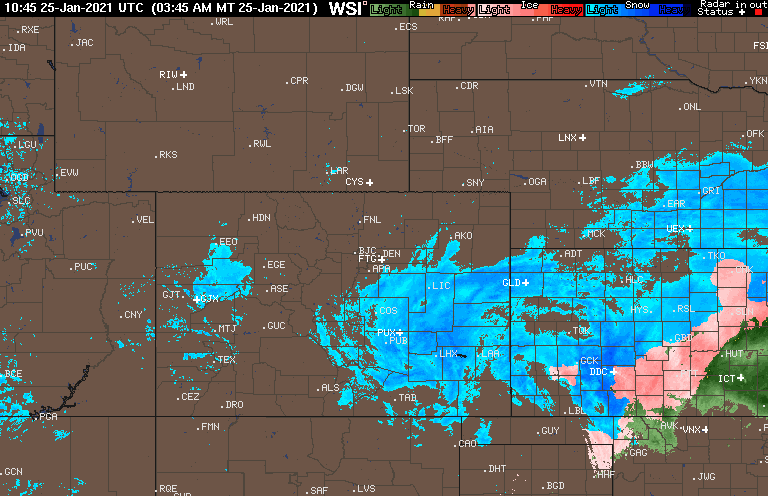
A second, more beefy lee cyclone has rapidly developed in southeast Colorado this morning. This system is already too far southward with downslope widespread across the Front Range as of Monday morning. This low will continue to pull east early in the week spreading winter weather across the country. This morning’s radar animation shows the impressive shield of snowfall which has unfortunately already bypassed our area without producing a flake. Expect accumulating snow east of DIA to the Kansas border throughout much of Monday morning.
Our focus right now is on the approaching low to our southwest in California which will slowly migrate from the Baja into the Four Corners region by tomorrow afternoon. With this track, it will offer a chance of light snow for the entire Boulder and Denver Metro area, beginning Monday evening and continuing in light and intermittent fashion through Tuesday evening. Like has been the case so, so many times already this winter, moisture and energy with this system are severely limited, so don’t set your bar too high with this storm. Let’s look at some of the key factors influencing this snow event, paired with the four-panel diagram below….
- Upper left: The track of the low is too far south passing through northern Arizona and New Mexico in the coming days. Even worse, there is very little energy available northward of the low pressure itself. Most energy will wrap around the southern tier of the storm and largely bypass northern Colorado.
- Upper right: Both the subtropical and polar jet streams are present, but again are too far south. Colorado is firmly entrenched in the cold airmass with no overhead jet forcing in-play this time around.
- Lower right: The fact that we’re solidly within the cold airmass will play into this next point…Moisture is lacking across the entire western United States, mainly because the polar jet is so far south and has been for a handful of days already. There is some moisture overall the lower and middle atmosphere will be relatively dry tonight through Tuesday. Not dry enough to prevent light snowfall, but dry nonetheless.
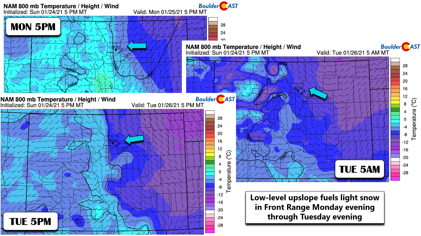
- Lower left: Though the core of the system will be a moving through northern Arizona and New Mexico (very far south), models are showing some signs of hope at the 700mb level with two “lobes” of low pressure forming. The one further north in Utah/Colorado, in conjunction with a Canadian high pressure in the northern Plains, will fuel an extended period of weak upslope in our area.
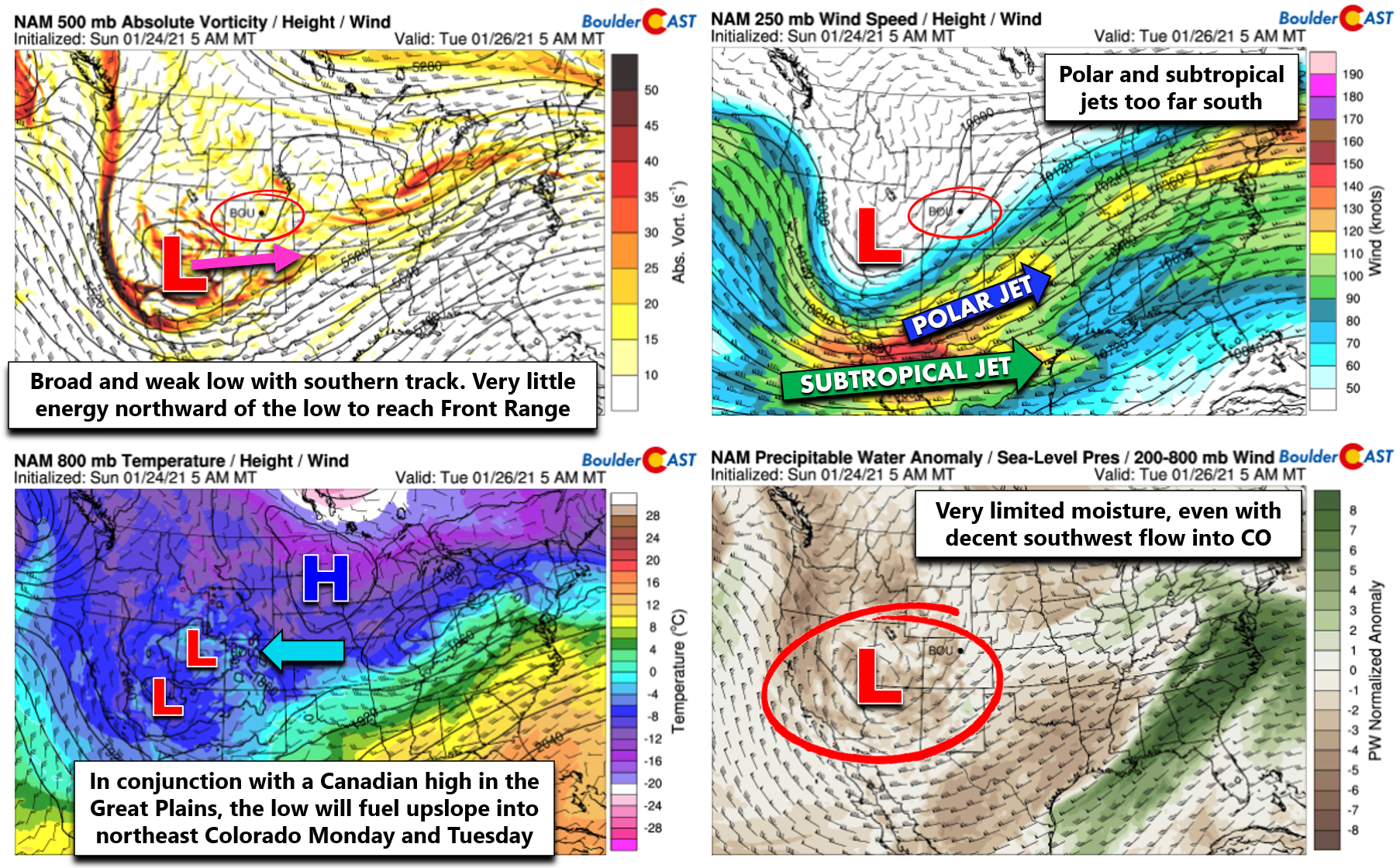
Four panel forecast graphic showing conditions Tuesday morning
As you can see, this system is lacking moisture and jet forcing. The track is once again not favorable with most of the lift passing too far south. However, as is the case so often in the Front Range, the easterly winds butting up against the topography can produce just enough lift to generate snowfall in what would otherwise be a dry scenario had the terrain not existed. The one favorable aspect of this snow event? With the large breadth and slow movement of the storm, easterly flow will be present across our area from Monday afternoon into Tuesday evening. That’s a solid 24-hour window for light upslope snow. It certainly will not be snowing the entire time as the easterly winds wax and wane in intensity and change direction slightly through the period. In particular, winds look to shift to southeasterly Tuesday morning (right panel below) which would tend to shut off the snow for the Denver Metro area. However, by Tuesday afternoon and evening, we may see a re-intensification of the upslope with a shift towards a more favorable northeasterly direction (bottom left panel below).
Light snow will be possible anytime from Monday afternoon into portions of Tuesday evening, especially in upslope-favored areas in the lower Foothills and the immediately adjacent Plains like Boulder. It’s hard to say exactly which periods will see the most widespread snowfall across the Front Range as there is fairly poor agreement in the models right now in regards to upslope direction, intensity, depth and timing.
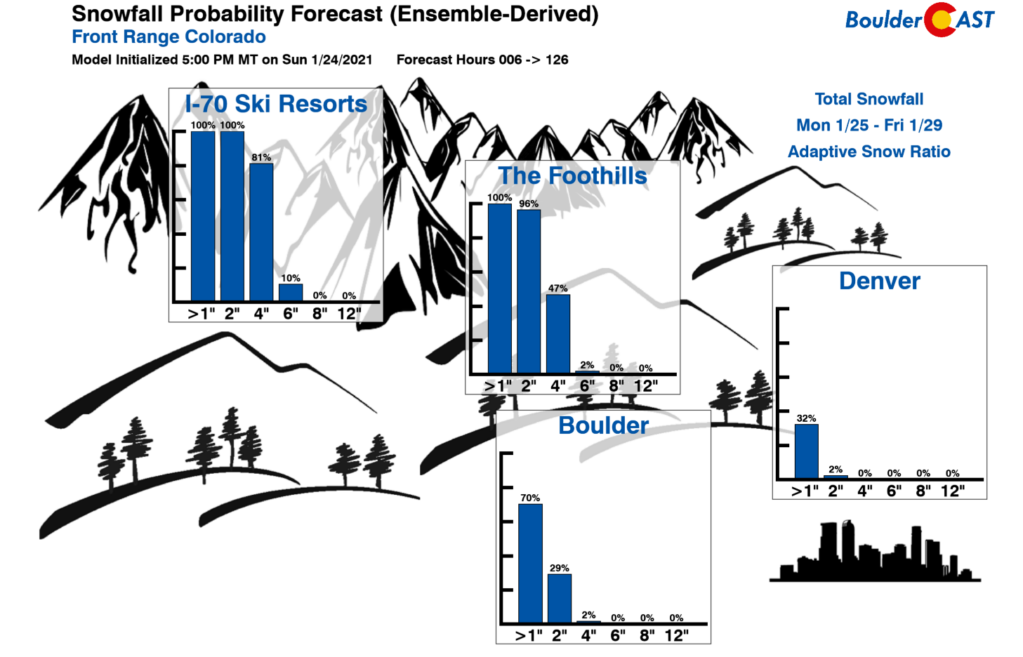
Since low-level upslope is really the only game in town here (plus a little instability), it makes predicting the exact behavior of the light snow challenging over the next two days. Regardless of which model solution verifies, we expect only light accumulations with this storm by the time things are all said and done Tuesday night.
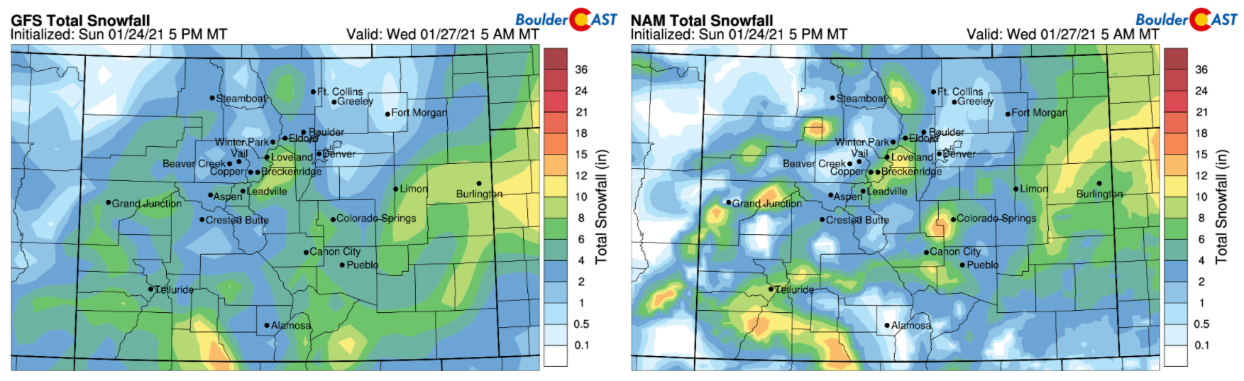
Model-derived snowfall forecasts through Tuesday night from the GFS (left) and NAM (right) models
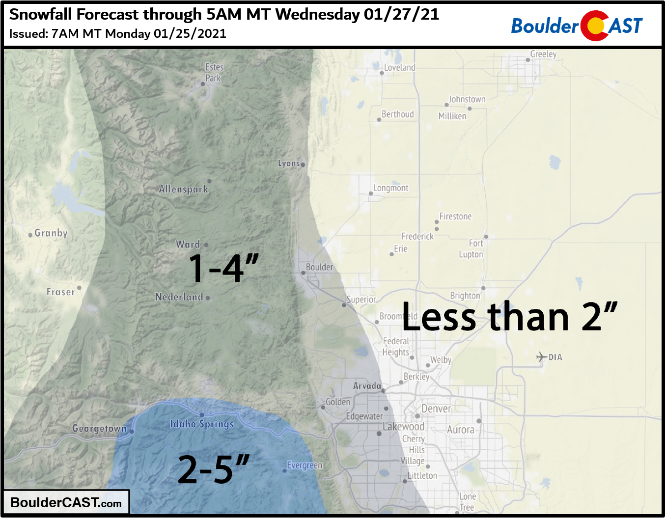
Our snowfall forecast map for the event is shown below. This covers snow falling all the way through Tuesday night. Don’t expect all this snow to fall at once or be on the ground when you wake up Tuesday morning.
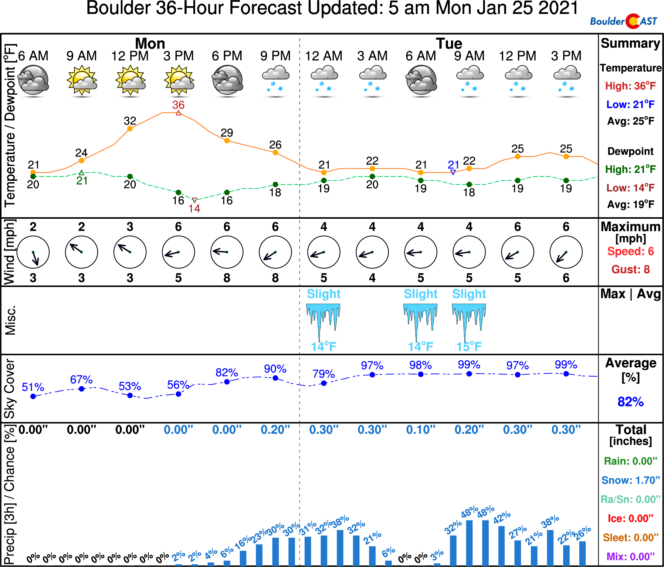
As mentioned earlier, northeast Colorado will remain deeply entrenched in the cold air as this system passes. Highs on Monday will only be slightly above freezing. On Tuesday, we’ll be stuck in the low to middle 20’s. Whatever snow does fall should have little trouble sticking. Do watch for some snow-covered roadways at times, especially during the evening and overnight periods when the sun is down.
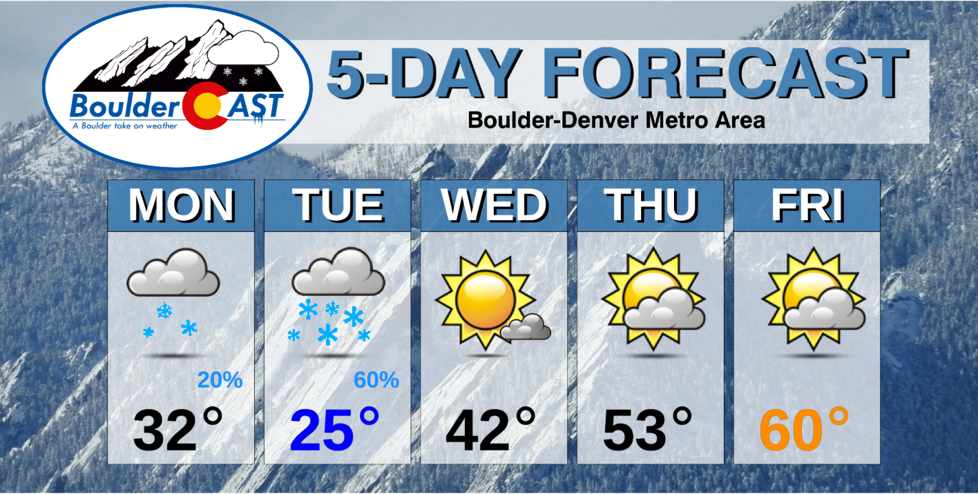
Drying out and warming up mid-week
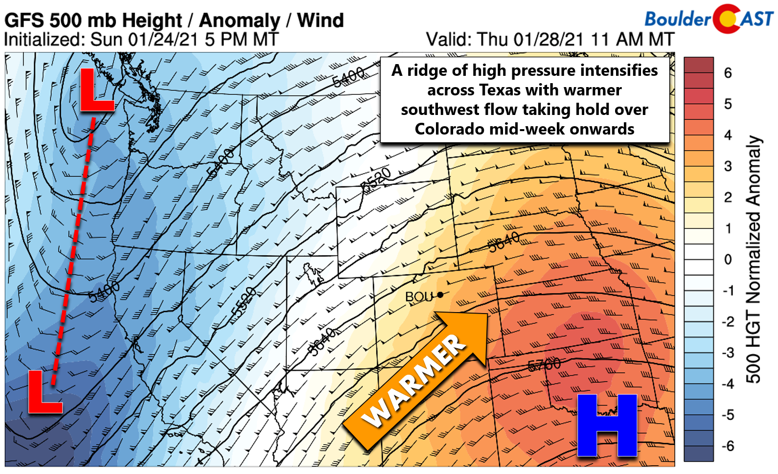
As the sun rises Wednesday, this round of unsettled weather will have wrapped-up across Colorado. Flow will shift to southwesterly and intensify leading to a significant warming trend for Colorado as high pressure builds across Texas. The 500mb height anomaly map below is for Thursday. We’ll have a few pleasant days under the influence of this high pressure before yet another series of storm systems dip into California and then kick eastward through the Four Corners in a very similar track to the one early this week. Highs for Denver will climb into the 40’s Wednesday, the 50’s Thursday, and close to 60°F by Friday.
With a troughy pattern indicated for the upcoming weekend, we could see another round of light snow, though it doesn’t appear likely at the moment with the approaching storm essentially fizzling out before it reaches Colorado. The Mountains may see additional accumulations Saturday or Sunday, but the lower elevations around Boulder and Denver should remain entirely dry with cooler temperatures expected behind a cold front dropping southward.
GFS 500mb height anomaly forecast animation from Wednesday through Saturday showing at first a building ridge for Colorado, but troughy/unsettled weather returning over the weekend
Despite the continued onslaught of storm systems impacting Colorado week after week, the resulting meager precipitation has left much to be desired. The drought situation remains dire statewide and the snowpack situation isn’t much better either. We’re hopeful but not optimistic that a major pattern change will take hold soon to prevent what very well could be another devastating fire season developing for the summer and autumn ahead.
Forecast Specifics:
Monday: Mostly cloudy and cold with a few flurries through the daytime hours. Light snow develops by evening and continues intermittently overnight with a dusting to 2″ of accumulation by sunrise. Highs in the low to middle 30’s on the Plains and middle 20’s in the Foothills.
Tuesday: Bitterly cold, overcast and occasionally snowy with highs in the middle 20’s on the Plains and teens in the Foothills. A dusting to 2″ of additional accumulation possible through the day into evening.
Wednesday: Mostly sunny and dry but still chilly with highs near 40 degrees on the Plains and in the upper 20’s in the Foothills.
Thursday: Thick wave clouds but some sunshine too and warmer temperatures. Highs in the lower 50’s across the Plains and in the upper 30’s in the Foothills.
Friday: Partly to mostly sunny and warm with a few wave clouds. Temperatures in the upper 50’s across the Plains with middle 40’s in the Foothills.
Weekend: More seasonal temperatures with highs in the middle 40’s to lower 50’s. Both days appear dry for the Denver Metro area.
Mountains: Snowy conditions will exist over the higher terrain Monday and Tuesday, but accumulations will be light in most of the state (just an additional 1 to 4″). Heavier snow will impact the San Juans with an additional 4 to 10″ there. Wednesday through Friday will be dry with increasingly strong southwest flow in the Mountains. The next chance of snow will come over the weekend, but accumulations should be minor…perhaps a couple of inches at most and also favoring southern Colorado.
Help support our team of Front Range weather bloggers by joining BoulderCAST Premium. We talk Boulder and Denver weather every single day. Sign up now to get access to our daily forecast discussions each morning, complete six-day skiing and hiking forecasts powered by machine learning, first-class access to all our Colorado-centric high-resolution weather graphics, bonus storm updates and much more! Or not, we just appreciate your readership!
.
Spread the word, share the BoulderCAST forecast!
.


You must be logged in to post a comment.