A strong storm system will move into Colorado during the day on Wednesday producing heavy snow in the Mountains. It will then kick eastward across the Denver Metro area Wednesday evening and night with a chance of rain changing to snow. We discuss the timing, amounts and provide our snowfall forecast map. Let’s take a look!
At a Glance:
- A strong, jet-driven storm system will impact Colorado today into tonight, after we briefly touch 60 degrees again this afternoon
- The heaviest snow will be in the Mountains above 10,000 feet where up to a foot could fall by Thursday morning, with pockets of thundersnow
- As we feared, the Boulder area will largely be bypassed with this storm thanks to quickly developing downslope
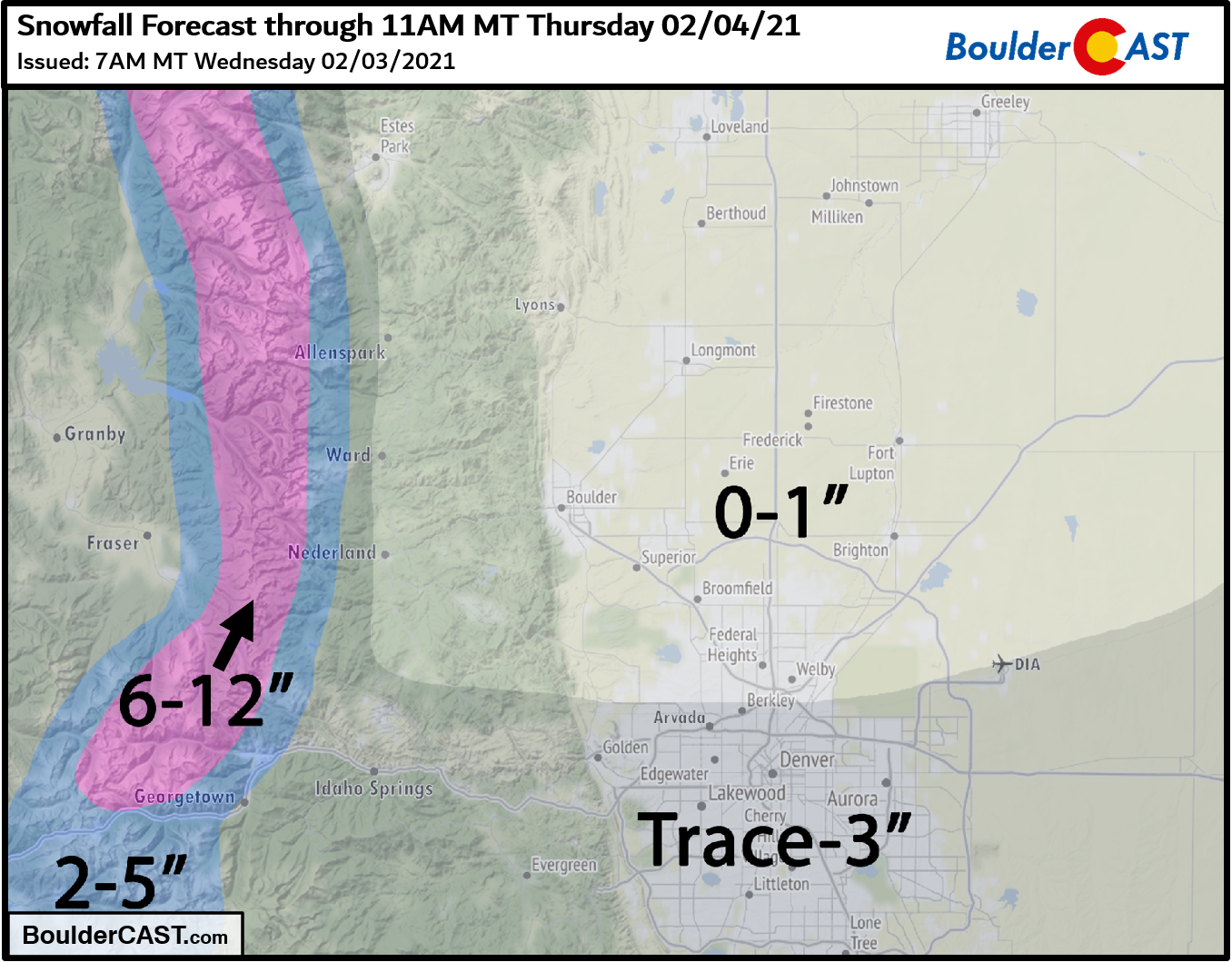
- Rain changing to snow later today with totals up to 3″ south of Denver, with nothing to 1″ elsewhere
- Thursday will be chilly, sunnier and breezy with highs in the 30’s
Help support our team of Front Range weather bloggers by joining BoulderCAST Premium. We talk Boulder and Denver weather every single day. Sign up now to get access to our daily forecast discussions each morning, complete six-day skiing and hiking forecasts powered by machine learning, first-class access to all our Colorado-centric high-resolution weather graphics, bonus storm updates and much more! Or not, we just appreciate your readership!

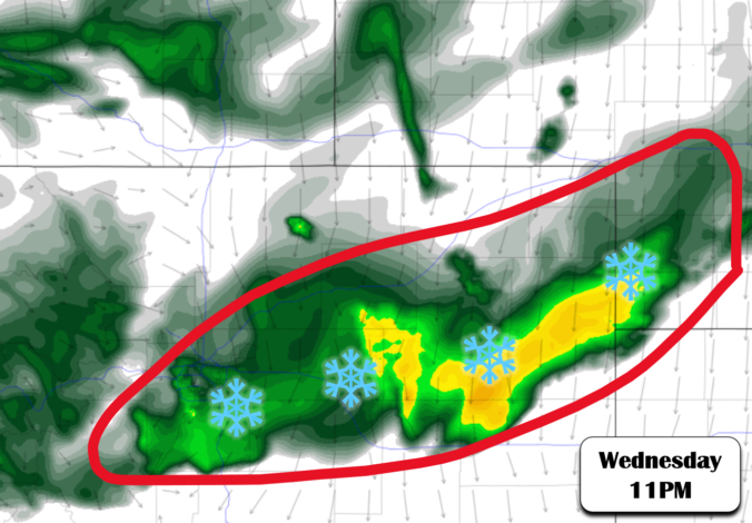
Not our bands!
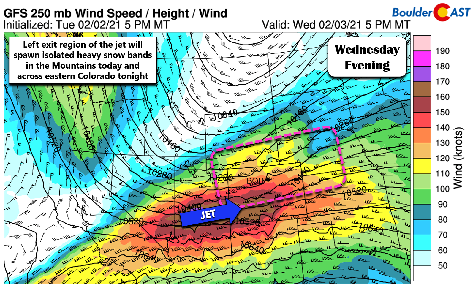
We’ve been monitoring this particular winter storm for a week or so at this point and it did have potential. Unfortunately, this system will largely bypass the Denver Metro area with strong downslope arriving too quickly, essentially nixing the chance of much snow across the entire area. This fear of ours was discussed in our lengthy forecast update yesterday. Nothing has changed since then. The main forcer for snow tonight will be an overhead jet max, with speeds up to 180 MPH overtop of Colorado. Much of the state will be in the left-exit region of this jet opening the door for isolated bands of heavy jet-forced snowfall.
In the Mountains, banding will be in-play this afternoon into portions of the evening. These bands, combined with moist upslope flow west of the Continental Divide will lead to difficult travel in the High Country today and tonight. We’re expecting 4 to 12″ above 10,000 feet, with the highest amounts in areas with the best western exposure.
We’re already seeing a fairly significant amount of lightning strikes upstream this morning in Utah and Wyoming with this jet-max.
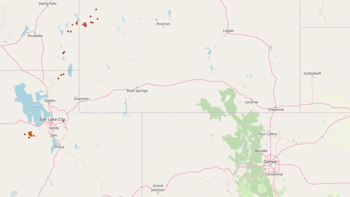
Red dots are detected lightning strikes from Wednesday morning
This energy will spread across Colorado through the day leading to the potential for thundersnow at times in the Mountains. This is supported by model data as well, which indicate up to 300 J/kg of convective available potential energy across the High Country this morning and afternoon.
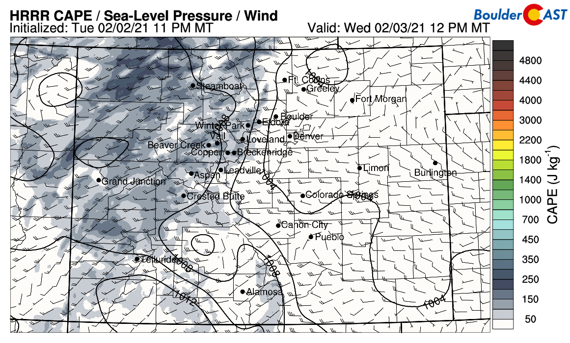
CAPE forecast for this afternoon shows enough instability to support isolated thundersnow
Across the lower elevations of eastern Colorado, the window for potential banding will be this evening. The high-resolution HRRR model has confirmed our initial suspicions that most (if not all) of the snow bands around Denver will occur south of Interstate 70. The simulated radar animation from the model for today into tonight is shown below.
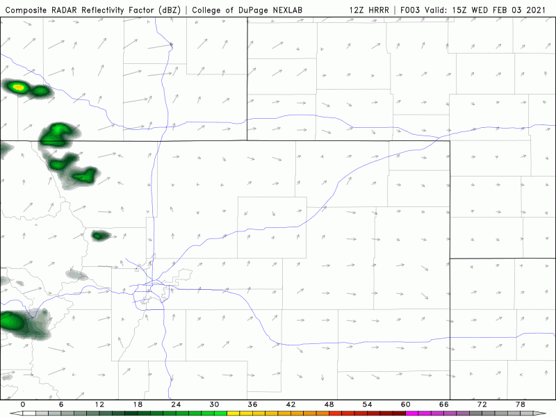
HRRR model simulated radar animation for Wednesday into Wednesday night
The result will be very little to no snowfall across northern portions of the area. Boulder could see a few raindrops/snowflakes later today and tonight, but most of the accumulating snow will be further south. The downslope effects will be strongest around Boulder into Fort Collins and thus snowfall will be least there. The best chances for banding will be from central Denver southward to the Palmer Divide tonight, mainly between 9PM and 3AM.
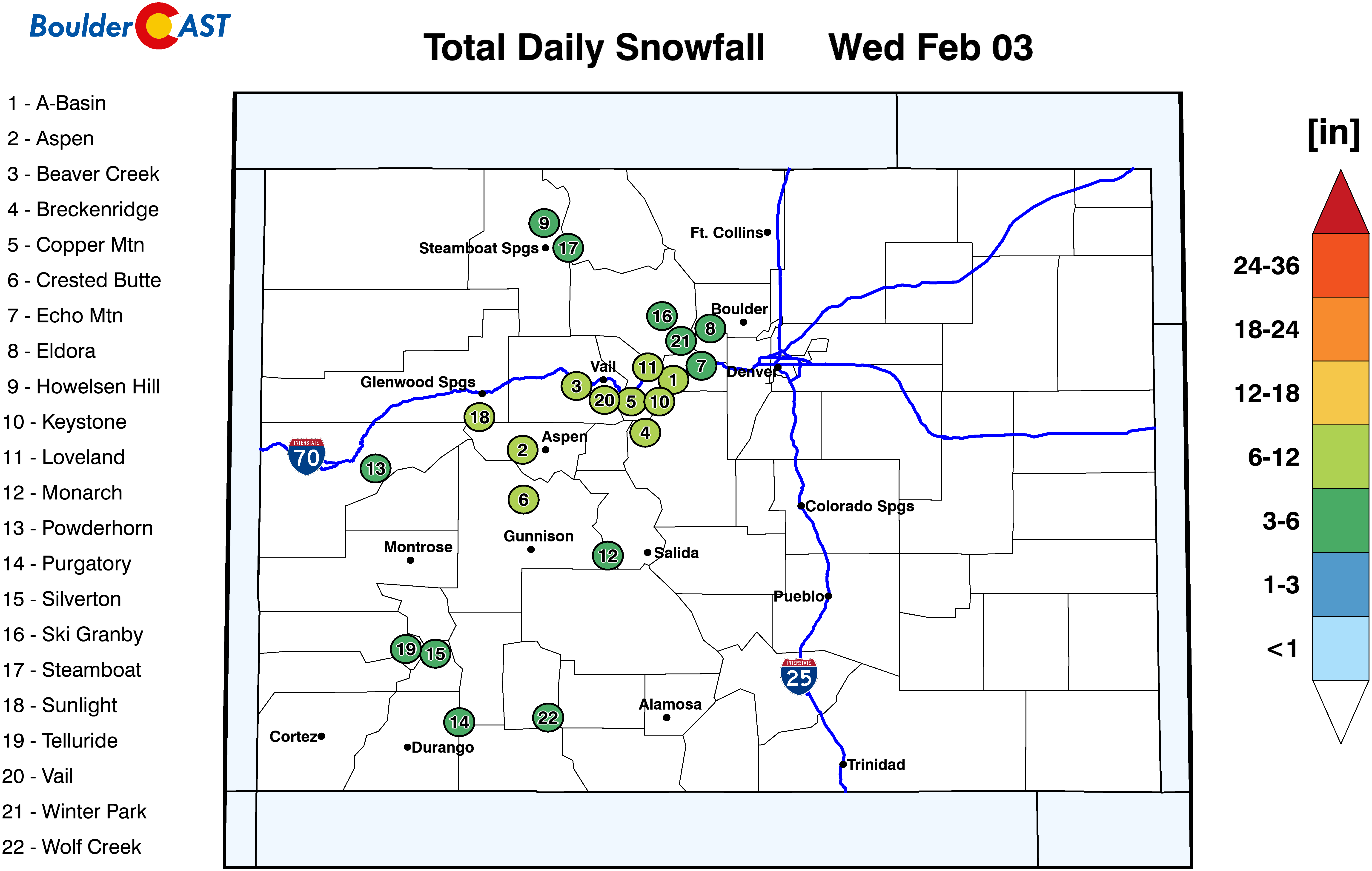
Our snowfall forecast map for the event is shown below. It just highlights the details we’ve already discussed.
After the storm moves past, Thursday will be chilly but sunnier with highs in the middle 30’s. Breezy conditions will be possible in the afternoon with gusts of 20 to 25 MPH common across the region.
Our next chance of winter weather arrives Friday night into early Saturday behind a more potent, Arctic cold front. It’s unclear at this point if this front will make a direct hit on our area or offer just a glancing blow. The finer details will determine if any accumulating snow will be possible Saturday, or if it will be more of a freezing drizzle type of event (or even if there will be no precipitation at all). Given the shallow and very cold nature of this front, any snowfall would be on the light side. We’ll keep you updated, so make sure you are subscribed and following us on Facebook and Twitter.
We hope you are able to get outside and enjoy the 60-degree weather early Wednesday afternoon before the cold front arrives!
Get BoulderCAST weather updates delivered to your inbox!
We respect your privacy. You can unsubscribe at any time.
Help support our team of Front Range weather bloggers by joining BoulderCASTPremium. We talk Boulder and Denver weather every single day. Sign up now to get access to our daily forecast discussions each morning, complete six-day skiing and hiking forecasts powered by machine learning, first-class access to all our Colorado-centric high-resolution weather graphics, bonus storm updates and much more! Or not, we just appreciate your readership!
.
Spread the word, share the BoulderCAST forecast:
.


You must be logged in to post a comment.