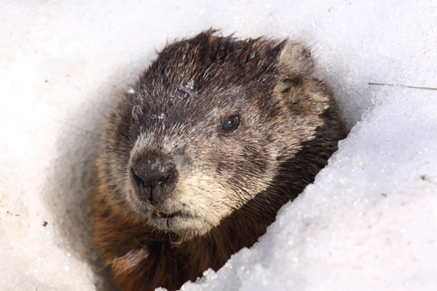
⦁❶⦁ Despite Phil’s wintery prediction earlier this morning, our temperatures will soar into the 60’s today and tomorrow
⦁❷⦁ A quick-hitting trough will bring a chance of snow to the Front Range Wednesday night
⦁❸⦁ Even with decent lift and a potent jet core overhead, downslope looks to be too much to overcome northwest of Denver with this system
⦁❹⦁ Expected accumulations are minimal, but as always forecasting jet snow is tricky so stay tuned!
Do you want the latest BoulderCAST Daily forecast discussion delivered to your inbox every single morning? If so, join BoulderCAST Premium where we talk Boulder and Denver weather every single day.

Detailed Forecast Discussion:
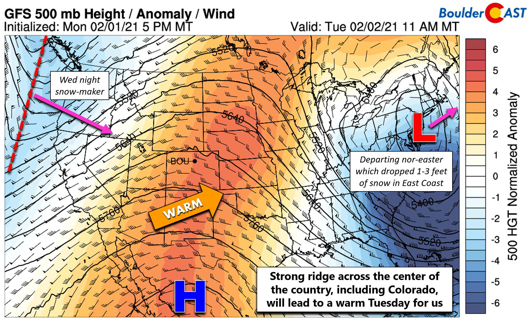
Just a short while ago this morning, Punxsutawney Phil the Groundhog saw his shadow indicating there will be six more weeks of winter for everyone! Of course, any meteorologist should be able to outperform an oversized rodent, and that we will do this week as the next two days will be very warm in the Front Range with temperatures in or near the 60’s for the lower elevations. The reason for the “spring-like” weather this week is the large ridge of high pressure which has developed and amplified across the center of the county (shown below). The ridge is sandwiched between our approaching snow-maker to the west and a departing nor’easter low pressure which has dropped one to three feet of snow along the I-95 Corridor (again!) .
We have a deep fetch of southwesterly flow in-play. Yesterday this flow was very rich in mid-level moisture, which made for a very gloomy, albeit mild Monday
The gloom in Boulder is intense right now…
More regional webcams: https://t.co/L0VLejKuY3#COwx #WaveClouds #Boulderwx pic.twitter.com/Q4xPoYwrI5
— BoulderCAST Weather (@BoulderCAST) February 1, 2021
Today, however, we will be mostly sunny. Not because the moisture aloft is gone, but instead because the ridge has intensified causing stronger sinking motion which has a warming/drying effect on the atmosphere above (just like downslope would). Expect mostly sunny skies with high temperatures in the low to middle 60’s. While this will be the warmest day we’ve had in a while, it’s nowhere near record territory. The record highs in Boulder and Denver are 75 and 74 degrees, respectively….so we’re not shattering those this afternoon. In any case, it will be a slap to the face of the Groundhog!
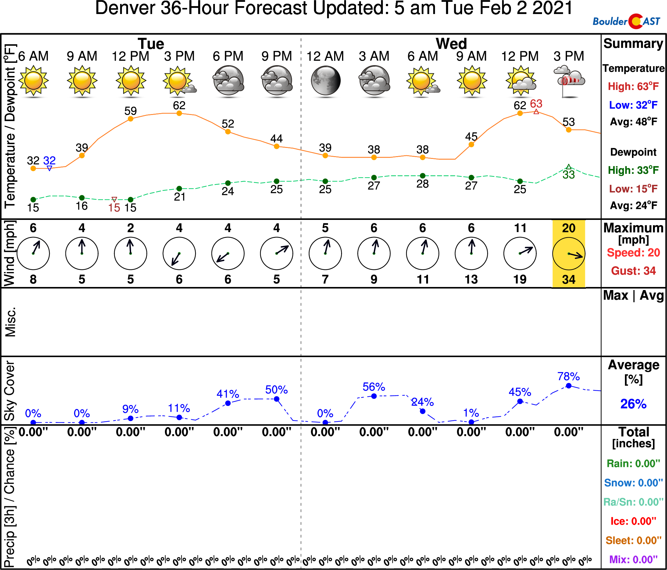
The ridge overhead is rather slow-moving and will influence our weather through the day today and into a portion of Wednesday. However, a quick-hitting storm system will blast across the Rockies Wednesday afternoon into Wednesday night bringing sharp changes to the Front Range. We’ll definitely be waving goodbye to those 60’s! The incoming storm is the one we gave you heads up about nearly a week ago. In the last day or two, models have increased the progressive nature of this system considerably. While initially it looked to be a mainly Thursday event for the Denver Metro area, the timeline has been accelerated with most if not all the expected snowfall occurring Wednesday night. The animation below shows the forecast trend for Thursday morning at 500mb from the GFS model over the last few days. Essentially, this is what the last 10 runs of the GFS have predicted for 5AM Thursday at 500mb.

GFS 500mb forecast anomaly trend animation with model runs from Monday and today for Thursday at 5AM. Essentially, this is what the last 10 runs of the GFS have predicted for 5AM Thursday at 500mb.
Notice towards the beginning of the animation that the trough axis was forecast to be closer to Salt Lake City at this time (which would favor lift/snow in the Front Range). However, as the animation progresses, we see that the trough shifts further east and the deepest anomalies move into far northeast Colorado. This change is due to the system moving much faster than model expectations and also a bit further north. Another very obvious shift over the last few days is the development of the cut-off low which breaks free along the southern edge of the trough. Initially this energy was expected to remain intact with the main trough itself, but as you can see, it’s now long-gone…forecast to drift westward off the coast of Baja California.
The trough is still a potent one, though, with most of the bells and whistles we want to see for snowfall. It’s just moving very quickly so the window for accumulating snow will be rather short, cut even shorter by developing downslope. This will ultimately be the limiting factor on snowfall totals across the Denver Metro area. The cold front will arrive Wednesday evening, blasting in from the north and northwest. The current timing on the front is around sunset, but with recent model trends tending to accelerate everything, it wouldn’t be surprising if the front moves through our area a little sooner. A combination of the frontal lift, lift from the trough, a little bit of upslope and concentrated lift from the left-exit region of the overhead jet will lead to a burst of moderate to heavy snowfall across eastern Colorado Wednesday night into early Thursday morning. The jet streak involved is actually a mixture of the polar and subtropical jet streams. It will be very strong with speeds close to 200 MPH at 35,000 feet.

As always, predicting the location of jet-forced banded snowfall can be challenging more than 12 to 24 hours in advance. Generally, models are targeting areas from Denver south and east with most of the banded snow.

Further north and west, very strong downslope behind the front looks to be too much to overcome. Therefore, areas from Arvada northward through Boulder and Fort Collins will likely see little to no snowfall from this event. It’s possible the downslope influence could expand further to wipe out the snow chances for the entire Metro area, but we’re still hopeful that some locations pick up a little banding considering the ingredients on the table.

For now, expect increasingly overcast conditions on Wednesday with temperatures reaching into the 60’s again. Snow will be widespread in the Mountains during the day with 4-10″ of accumulation. By evening, isolated rain showers will develop in the Boulder/Denver area and quickly turn to snow as the colder air arrives. The best chance for snow for us will be during the evening and overnight periods. Expected accumulations will range from next to nothing northwest of Denver to perhaps a couple inches southeast of Denver where banding is most likely.
The high-resolution models, those capable of fully resolving the fine-scale banding of the snowfall, will start to come into focus later today and tomorrow morning. This will give us a better idea of the specifics and if the downslope will truly bust this event in Boulder. Stay tuned!
Fun fact: My hometown in western Pennsylvania where I grew up was only about one hour away from Punxsutawney. However, I sadly never attended a single Groundhog Day celebration.
Remember, our daily forecasts are Premium content. Periodically, we open this forecast up to all of our readers. Today is one of those days!
Help support our team of Front Range weather bloggers by joining BoulderCAST Premium. We talk Boulder and Denver weather every single day. Sign up now to get access to our daily forecast discussions each morning, complete six-day skiing and hiking forecasts powered by machine learning, first-class access to all our Colorado-centric high-resolution weather graphics, bonus storm updates and much more! Or not, we just appreciate your readership!
.


You must be logged in to post a comment.