About half of the Front Range received snowfall right in line with our forecast last night, while the other half saw incredible snowfall amounts of a foot or more! What caused such an explosion of heavy snow in the heart of Denver last night? Let’s take a look.
We discuss Boulder and Denver weather every single day on BoulderCAST Premium. Sign up today to get access to our daily forecast discussions every morning, complete six-day skiing and hiking forecasts powered by machine learning, access to all our Front Range specific weather models, additional storm updates and much more!

At a Glance:
- Moderate to heavy snow bands developed and stalled over the Denver area Wednesday night leading to localized booming snow totals
- The band of heavy snow was created by a rare convergence of the winds forced by the surrounding terrain
- Snow totals ranged from 5 to 14″ across the Metro area, with the highest totals coming out of central Denver
- Strong downslope winds are expected on Friday with blowing snow likely
- A cold end to the month will solidify February 2021 as one of the coldest on record for us
WOW!
That’s all we can say after last night’s snowstorm dumped anywhere from 5 to 14″ of snow across many Front Range cities. We had a feeling that this storm would be an over-producer in some areas, updating our forecast relatively late in the game Wednesday afternoon, still a handful of hours before the snow started to fly. Our final words in that forecast update were as follows… “Is another surprise foot of snow in the cards tonight? It certainly is, but it may or may not ever reach the table.” We’d say that card was definitely dealt last night! However, no one could have imagined this snowstorm would boom so hard right in the heart of the Denver Metro area.
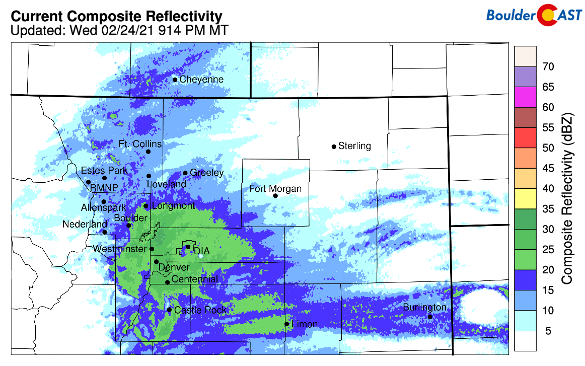
The snow outlook rapidly intensified as Wednesday progressed, with the National Weather Service expanding Winter Weather Advisories from just Boulder and Golden to the entire Denver area in the afternoon. This was certainly a good call and followed well with the model trends. By evening, though, heavy snow was parked across the entire Denver Metro area, as shown in the radar animation below from around 9:30 PM. Late in the evening, after 6 to 8″ of fluff had already fallen in many areas and no sign that the heavy snow would let up anytime soon, pretty much everywhere under this band was upgraded to a Winter Storm Warning.
When it was all said and done, anywhere from 5 to 14″ of snow fell from Longmont southward all the way to Colorado Springs. The heaviest dumping occurred right over the center of Denver with more than a foot of snow reported. Our snowfall forecast map for the event is shown below with storm totals overlaid in boxes. Green boxes indicate our forecast verified to within 1″. Red did not.
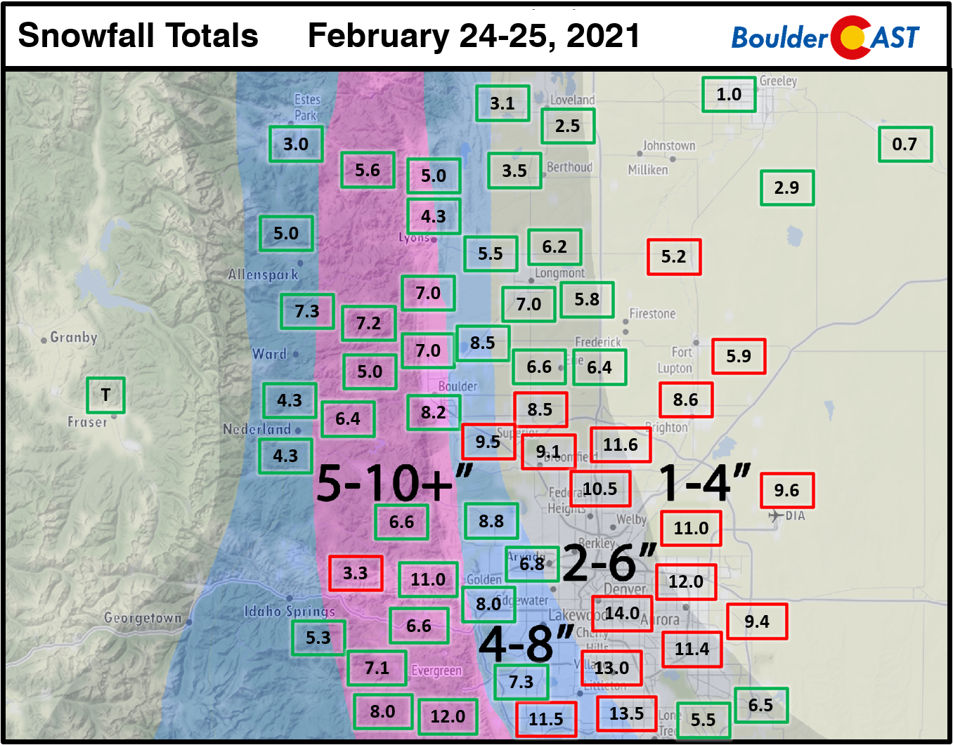
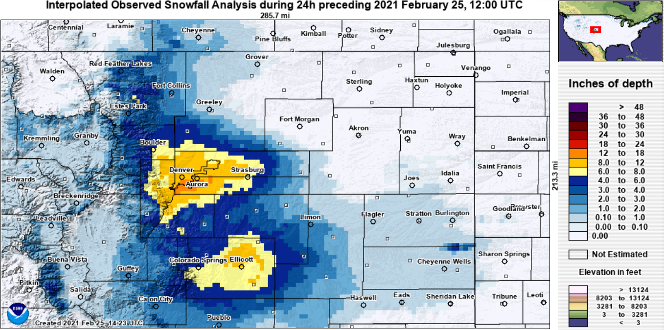
Yes, you’re reading that right. Double-digit snow totals were widespread across the Denver area. It was a bit of a mix bag however with some areas catching the heavy snow longer than others. This was the first “footer” in Denver proper since November of 2019. Officially Boulder reported 8.8″ of snow from this event, right on track with our forecast there. Denver’s official observation from DIA was 9.6″, incredible considering the strong expectations of very little snow out that way. Looking more broadly across all of eastern Colorado, we see that there was actually another bullseye with this snowstorm east of Colorado Springs. It wasn’t quite as intense as the one in our neck of the woods, though.
So why did this storm BOOM?
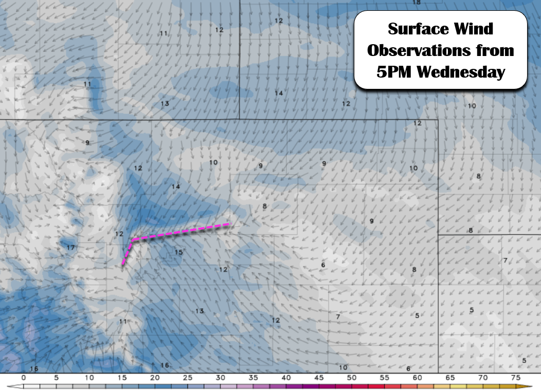
As things began to take shape early Wednesday evening, we were already seeing signs that the forecast might go awry. An arching band of very heavy snow dropped southward from Fort Collins and into Boulder. This band is the one that eventually ended up stalling over Denver through the night-time dumping hours of heavy snow in the Metro area. The graphic below shows how the heavy snow band matched up perfectly with a line converging winds where southeasterly flow and northeasterly flow were merging. It’s important to note that the bulk of the snow was located north of the convergence and over a fairly broad area. This is similar to how a warm front works, where a warm/moist airmass slowly glides up and over a cooler airmass, producing a broad shield of precipitation well north of the convergence line itself.
An arcing band of very heaving snow is sagging south across the Metro area. This band is driven by convergence. The winds from the southeast are overrunning the slightly denser air pushing in from the northeast. Per @keah88, this band has already produced 2"/hr in Longmont #COwx pic.twitter.com/5GemkpduCX
— BoulderCAST Weather (@BoulderCAST) February 25, 2021
Here’s a better look at the converging winds from Wednesday evening around 5:00PM. A setup like this happens frequently during the winter in the Front Range (about half of our cold fronts!), though usually the air surging southward is much colder and has a stronger push behind it. In most cases, this convergence might provide a brief burst of snow, but ultimately it does quick work and then moves along southward. This did not happen last night. The push coming from the south and the north were almost of equal intensity and the battleground where they met did not change very much for nearly 9 hours! This resulted in a relatively stationary band of moderate to heavy snow over Denver all night long. Truly a snow-lover’s dream!
This setup is actually a great example of a classic Denver Cyclone, a terrain-forced circulation that often occurs during the summertime in the Front Range. The line of convergence caused by this rotation is known as the Denver Cyclone Vorticity Zone (DCVZ) and it frequently acts as a sparking point for strong thunderstorms in the summer season. Last night’s DCVZ definitely produced thunderous results, but not the kind originating from lightning!
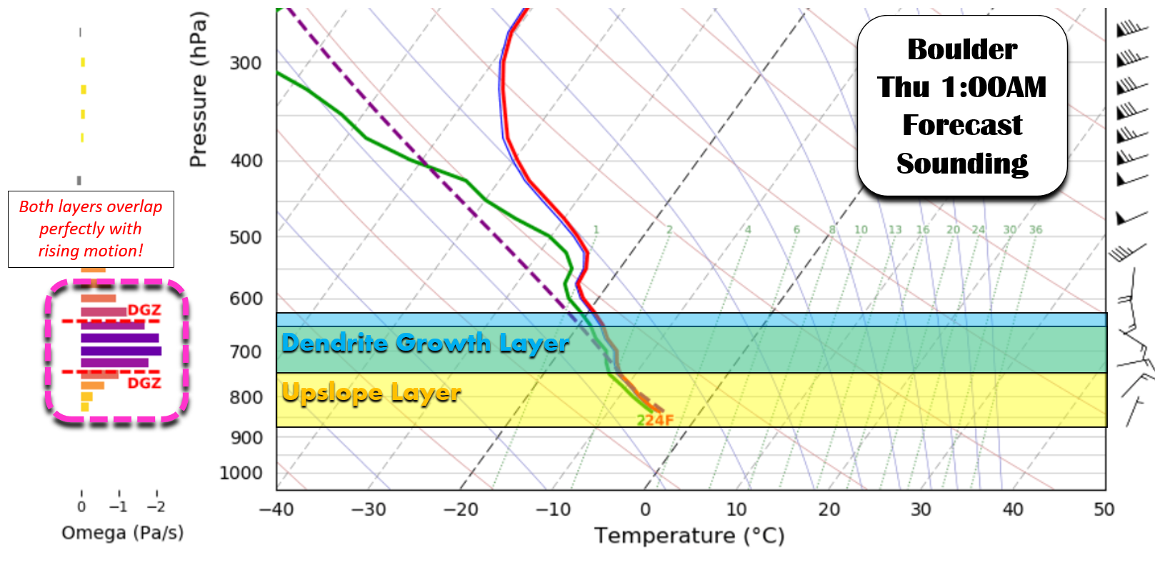
The stalled convergence line was critical for the heavy snow band to remain parked over the Denver area, but it was the atmospheric conditions aloft that were conducive for the growth of dendritic snowflakes that really put this storm over the top. The graphic below was part of our original forecast discussion showing that the upslope layer would overlap nicely with the dendritic growth layer in the atmosphere to produce big snowflakes that tend to boost accumulation very well with high snow to liquid ratios. The graphic was really demonstrating why the upslope interacting with the terrain would be so efficient at producing snow, but the same concept applies to the rising air along the convergence line.
Based on the snow observations from this event (both frozen and melted!), the snow to liquid ratios ranged from 15:1 to 19:1 across the Metro area. Here are just a few random examples:
- Boulder: 8.2″ snow, 0.55″ liquid = 14.9 ratio
- Broomfield: 9.1″ snow, 0.58″ liquid = 15.7 ratio
- Denver: 14.0″ snow, 0.75″ liquid = 18.7 ratio
- Aurora: 11.5″ snow, 0.60″ liquid = 19.1 ratio
- Arvada: 7.3″ snow, 0.47″ liquid = 15.5 ratio
- Littleton: 11.5″ snow, 0.62″ liquid = 18.5 ratio
- Golden: 11.3″ snow, 0.65″ liquid = 17.4 ratio
- Brighton: 8.5″ snow, 0.49″ liquid = 17.3 ratio
Ratios this high will equate to very fluffy snow which should be a breeze to shovel for everyone this morning or later today! If you’re interested in learning more about snow to liquid ratios and why they are so vital in every snowfall forecast, check out our deep-dive on this topic.
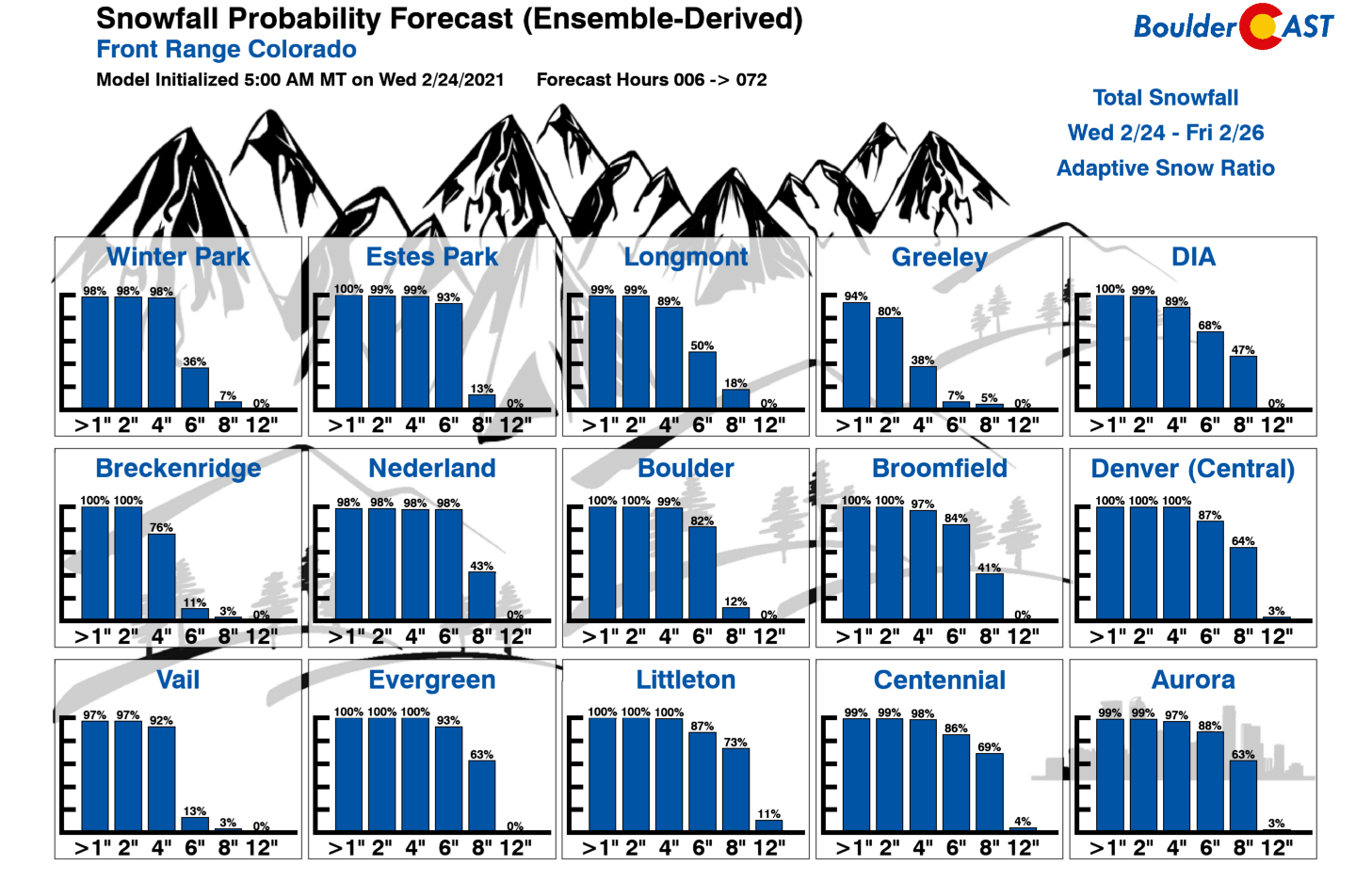
This event was one that the forecast models clearly struggled with, and as a result, just about everyone of us trying to interpret their data struggled as well. On the gauge of raw snowfall amounts, the GFS model verified best (take that Euro!). It was however the bullish outlier all along. The GFS didn’t predict this convergence line as it ultimately unfolded, so its accuracy seems to be more dumb luck than anything. We ended up not even mentioning the Snowfall Probabilities for this event in our forecast because they seemed heavily inflated due to the ingest of bullish GFS ensemble data. Our final set of probabilities before the snow commenced, shown below, actually painted a much more accurate picture of the outcomes.
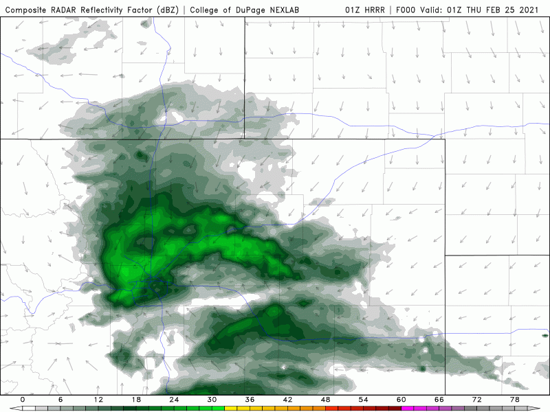
The higher-resolution models such as the HRRR, RAP and NAM-NEST models, had perhaps the best shot at predicting this rare Denver Cyclone infused winter storm, but they failed too. Once the setup was already in place, the HRRR model at least did anticipate that it would be rather persistent at dumping moderate to heavy snow throughout the night. It was likely this last minute model shift that caused the National Weather Service to panic and upgrade the entire Denver Metro area to Winter Storm Warnings. This forecast animation below from the HRRR model was initialized at 6PM Wednesday evening when heavy snow was already falling. It shows the surface winds and simulated radar. Can you pick out the swirl in the winds and reflectivity?
All things considered, our forecast didn’t turn out that bad. There were definitely some areas that boomed beyond even our wildest expectations, but more than half of the Front Range received their allocated snowfall as outlined in our forecast. The healthy dose of moisture injected to the area from this storm will go a long way towards helping with the ongoing drought, particularly across the immediate Denver Metro area where plenty of non-native plants and trees will be happy as the snow slowly melts in the coming days.
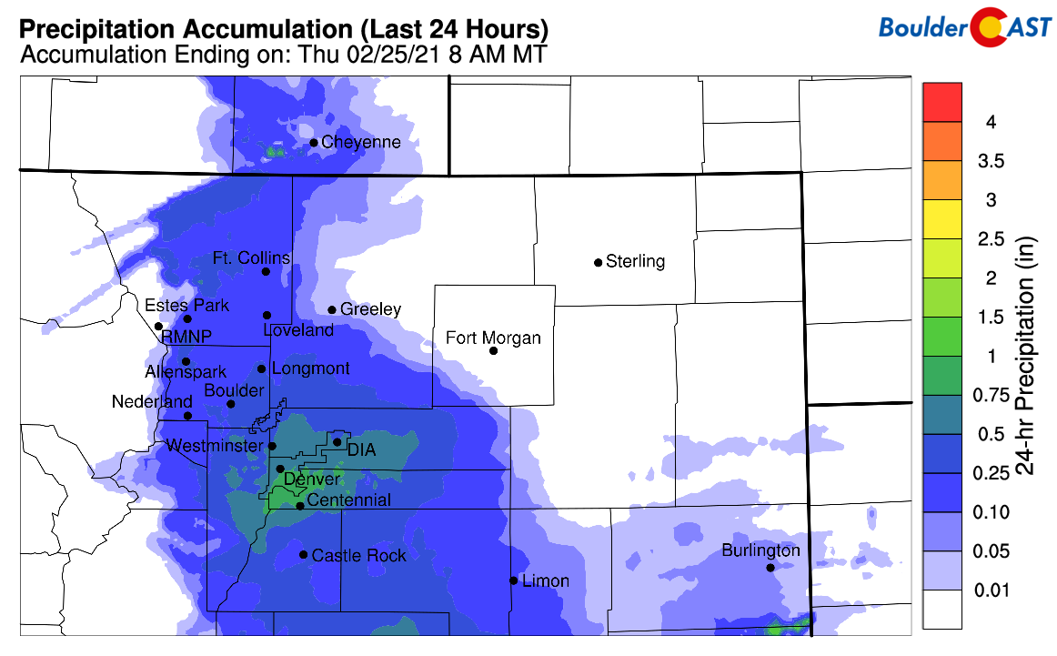
Estimated storm total liquid precipitation from the event
Looking ahead, we’re likely to see below normal temperatures persist through the end of the month solidifying February 2021 as one of the top 5 or so coldest in the historical record for many Front Range cities. We’ll more or less be in the 30’s to near 40 through Sunday.
One thing to watch, though, is the development of strong downslope winds Friday morning and afternoon as the polar jet stream dips back into Colorado. The winds won’t be particularly strong or intense by Front Range standards at least (30 to 45 MPH across the lower elevations), but due to the recent snowstorm these type of gusts will certainly create areas of blowing and drifting snow. If you’re traveling on Friday, consider the impact this could have on your plans, especially if they involve typically windy spots like Highway 93 between Boulder and Golden. In situations like this in the past, we have seen them shut down that stretch of road entirely!
That’s all for now. Enjoy the very snowy day with skies turning sunnier by afternoon!
We discuss Boulder and Denver weather every single day on BoulderCAST Premium. Sign up today to get access to our daily forecast discussions every morning, complete six-day skiing and hiking forecasts powered by machine learning, access to all our Front Range specific weather models, additional storm updates and much more!
.
Spread the word, share Colorado’s crazy weather:


You must be logged in to post a comment.