The weather models by and large are coming into a slightly snowier agreement this afternoon. We provide a quick update as winter weather bears down on the Front Range, including our final snowfall forecast map with totals adjusted upwards in many locations.
Help support our team of Front Range weather bloggers by joining BoulderCAST Premium. We talk Boulder and Denver weather every single day. Sign up now to get access to our daily forecast discussions each morning, complete six-day skiing and hiking forecasts powered by machine learning, first-class access to all our Colorado-centric high-resolution weather graphics, bonus storm updates and much more! Or not, we just appreciate your readership!

Watch for the boom!
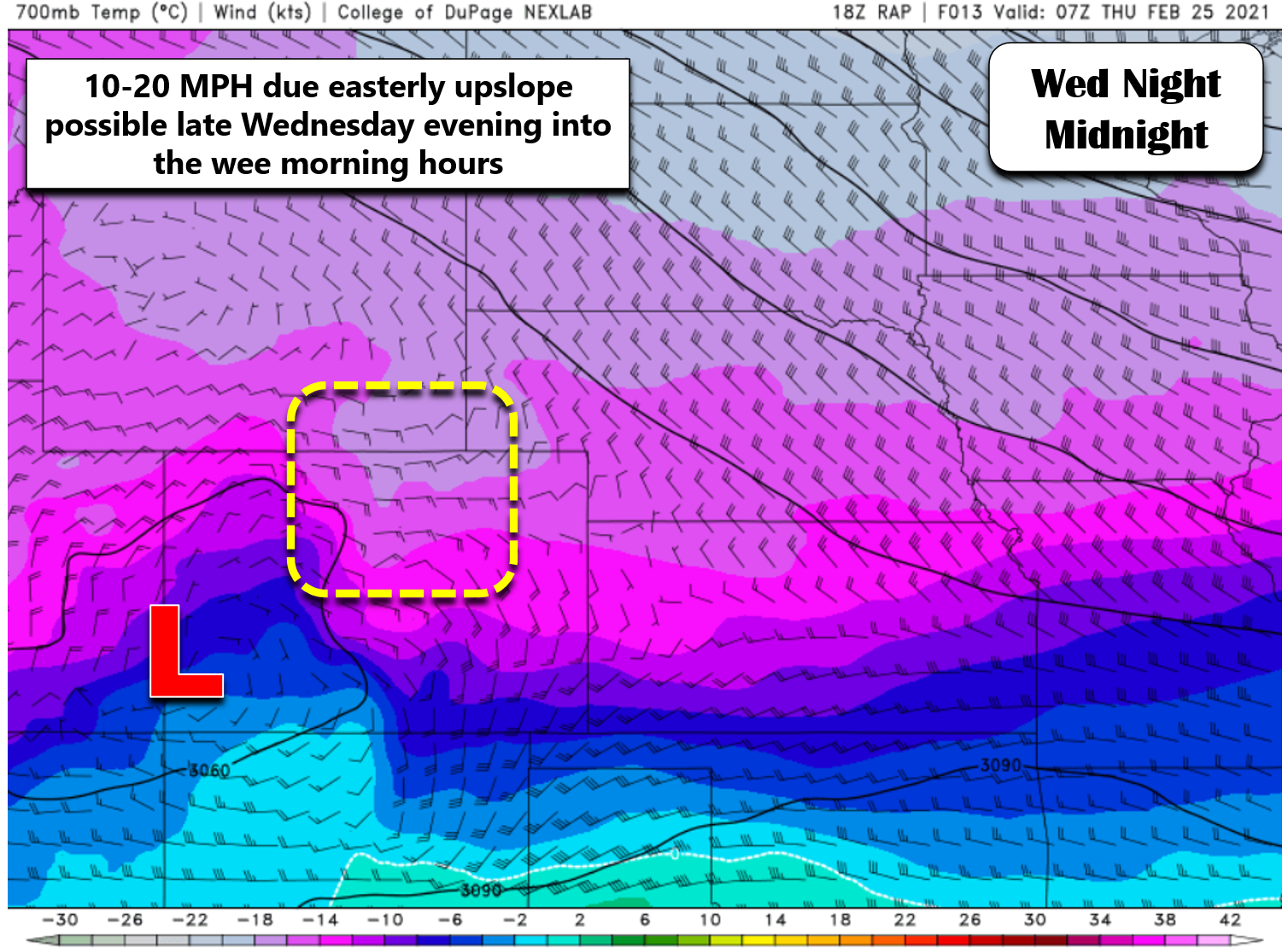
You can never underestimate the power of upslope in the Front Range. It is critical to almost every single rain and snow event we get from October through May. Over the last 24 hours, we’ve seen models start to converge on a solution that is a bit snowier than originally expected, though it was always a concern in the back of our minds. The GFS has come down in amounts, while the Euro has gone up allowing us to further fine-tune the forecast. The overall uptick in snow is largely due to an anticipated stronger surge of upslope Wednesday night. The difference between east winds of 10 MPH and 20 MPH might not seem that significant. In reality, the latter is twice as efficient of upslope as the former. The stronger upslope surge appears to be related to the storm system remaining intact longer. The closed-low pressure at 700mb tonight, shown below, will help to “pull in” that stronger easterly upslope to the Front Range.
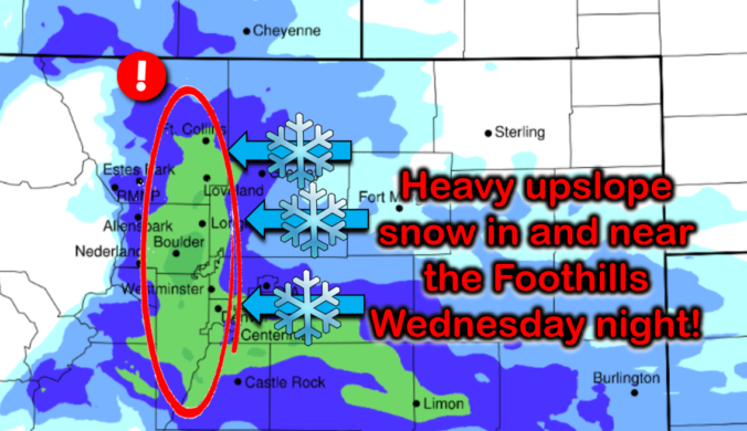
During this time of the strongest upslope tonight, roughly from 5PM to 2AM, moderate to heavy snowfall will likely impact the western Metro area, especially those spots right along the base of the Foothills. The strengthening of the upslope will also spread more snow further east away from the terrain. There’s still certainly going to be a gradient, but now it will be blurred a little…
High-resolution models, which now have a clear picture of the winter weather about to unfold, are mostly all on-board with our original expectations. There is a clear signal of a north-south oriented band of heavy snowfall right along the Foothills and the far western Denver Metro area late this evening, as seen in the HRRR model-simulated radar animation below. This makes sense given the upslope intensity and direction.
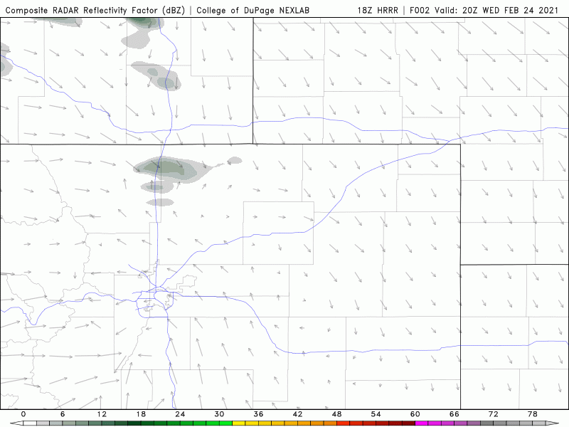
In case you are wondering, the resulting snow totals this model generates from these heavier snow bands are impressive. This forecast map below may not be that far from reality, as snowfall rates in the heavier bands of snow could easily be 1 to 2″ per hour.
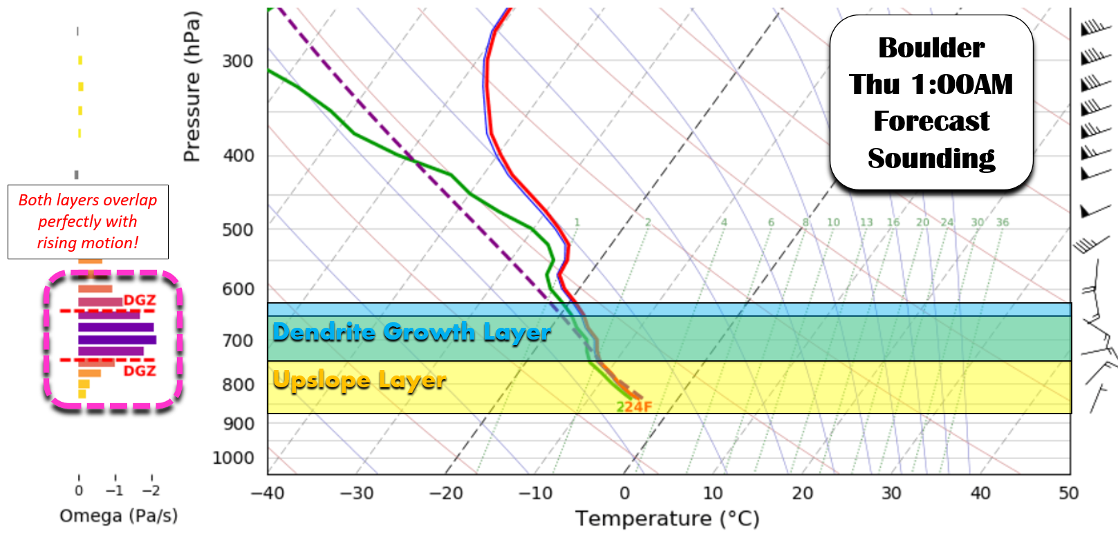
We haven’t even touched on snow ratios yet but they look promising as well. We’re forecasting ratios of easily 15:1 tonight, if not higher. Notice the clear overlap in the yellow upslope layer and the blue dendrite growth layer in the atmosphere of the forecast sounding below. Together, these two layers make for a nice juicy green layer where big fluffy snowflakes will be generated. Ratios closer to 20:1 may not be out of the question tonight!
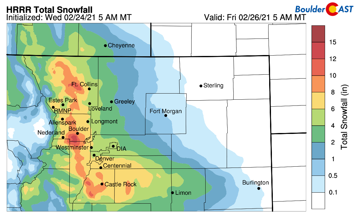
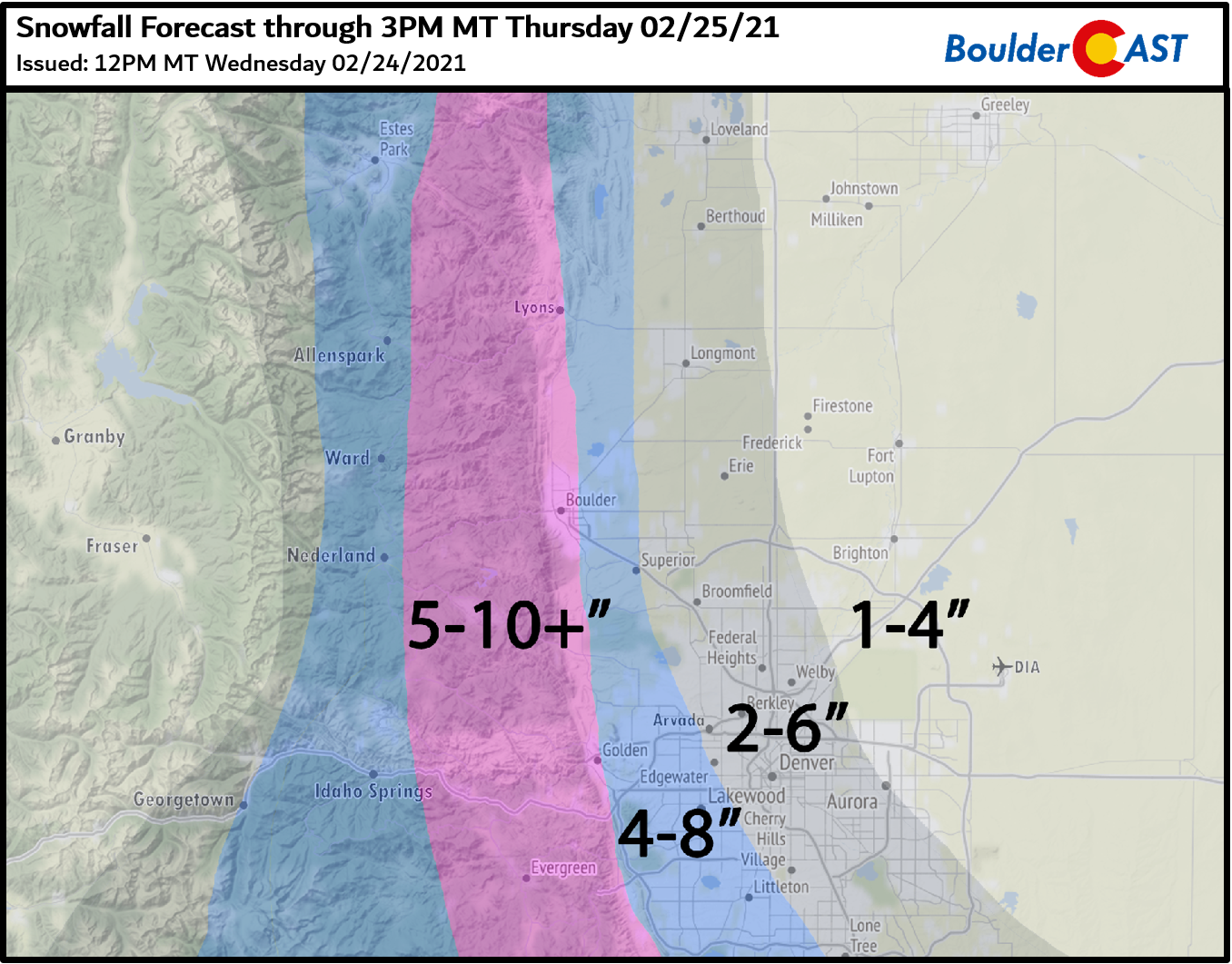
All things considered, we’re bumping up snow totals a little and blurring the overall gradient from west to east. Our updated and final snowfall forecast map for the event about to unfold is shown below. We’ve added a few inches since our forecast update yesterday. The far western Metro area will still do best with this storm. Our pink-shaded forecast of 5-10″ in the western suburbs and lower Foothills should do mostly alright, but it wouldn’t be surprising for localized areas to near a foot. Hence the “+” symbol.
The heaviest snow will be done with by sunrise Thursday and snow will taper off from north to south through the morning hours. Obviously the Thursday morning commute will be impacted, especially along and west of Interstate 25. Plan ahead and use caution as roadways will vary from a little messy to ugly.
A recent and potentially good historical analog for tonight’s snow event is what occurred back on Veterans Day 2018. That storm arrived to us in almost an identical manner, with a track too far into the Four Corners but with a favorable period of enhanced upslope progged for the Front Range. Our team’s forecast called for 5-9″ along the Foothills with a sharp gradient trending down to 1-3″ near DIA. Sound familiar? Ultimately, the models (and us) underestimated just how strong the upslope would be! The enhanced upslope snow bands absolutely dumped on areas right along the base of the Foothills with 1-2″ per hour snowfall rates. That particular storm put down 10 to 14″ of snow in the vicinity of Boulder. Is another surprise foot of snow in the cards tonight? It certainly is, but it may or may not ever reach the table….
Get BoulderCAST weather updates delivered to your inbox!
We respect your privacy. You can unsubscribe at any time.
Help support our team of Front Range weather bloggers by joining BoulderCASTPremium. We talk Boulder and Denver weather every single day. Sign up now to get access to our daily forecast discussions each morning, complete six-day skiing and hiking forecasts powered by machine learning, first-class access to all our Colorado-centric high-resolution weather graphics, bonus storm updates and much more! Or not, we just appreciate your readership!
.
Spread the word, share the BoulderCAST forecast:
.


You must be logged in to post a comment.