It’s been a glorious start to the week so far with highs getting back above normal on Monday and Tuesday. Even though it was quite breezy at times, temperatures flirting with 60 degrees took the chill right out of the wind. The stretch of fair weather changes very soon as two cold fronts and a taste of winter weather bear down on Colorado. A widespread, upslope-driven snowfall event is gearing-up for Wednesday evening into Thursday. Let’s take a look at the timing and snowfall amounts expected across the Front Range!
UPDATE (Wed 2/24/21 7:00AM): Updated snowfall forecast map, fine-tuning amounts and the position of the expected sharp gradient. Details of these changes are included in Wednesday morning’s Premium weather discussion, found HERE.
At a Glance:
- The 60’s of Tuesday will be replaced by 30’s the next few days following a cold front frontal passage
- It will be slow to develop, but a purely upslope-driven snowfall event arrives late Wednesday
- Look for a tight east-to-west gradient in snowfall heading away from the terrain
- Expected snowfall totals of up to 8″ in the Foothills and the western Metro area, but less than 1″ east of Denver
Help support our team of Front Range weather bloggers by joining BoulderCAST Premium. We talk Boulder and Denver weather every single day. Sign up now to get access to our daily forecast discussions each morning, complete six-day skiing and hiking forecasts powered by machine learning, first-class access to all our Colorado-centric high-resolution weather graphics, bonus storm updates and much more! Or not, we just appreciate your readership!

Upslope is the only game in town
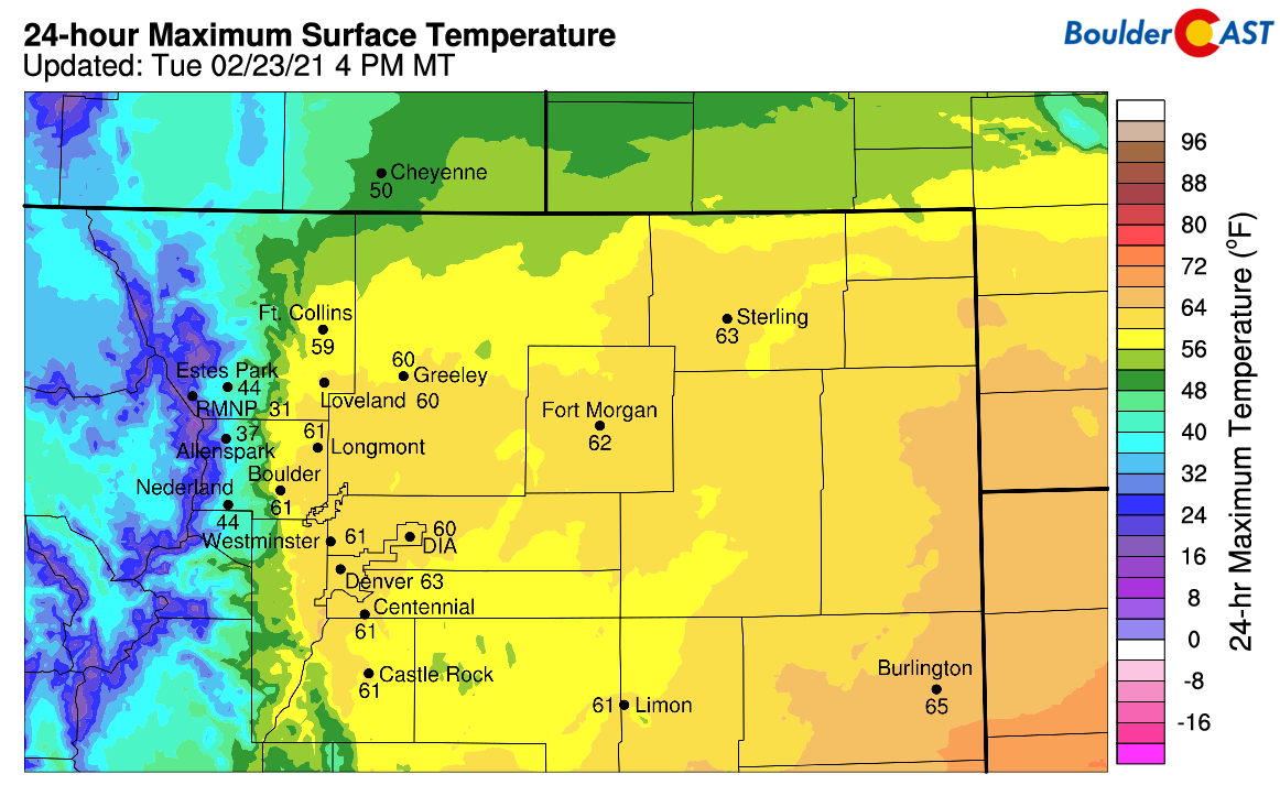
Boulder hit 60 degrees for the first time in three weeks today! We reported an early afternoon high of 62°F at BoulderCAST Station before slightly cooler air filtered in. Judging by the regional high temperature map today, many locations got close to this threshold as well….
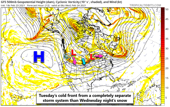
The warm stretch is about to end, though…isn’t it always? A cold front is approaching from the north (see below) and should arrive to the Denver Metro area early Tuesday evening with temperatures trending downward more than usual overnight. Highs on Wednesday will only make it back into the 30’s with cool upslope flow holding strong.

The cold front this evening is associated with a completely separate storm system than the one that will bring the snow Wednesday night. The parent low of the cold front is located all the way up in the Dakotas and Minnesota. This front will simply cool us off; it doesn’t have enough lift or moisture to do anything more just yet.

The snow-maker we are watching is actually still located in British Columbia as of Tuesday evening. Its projected track will take it sharply southward into the Four Corners region by Thursday morning, as shown in the animation below.
For what seems like the tenth time in a row (really, we’re not kidding), this storm will pass too far south and west of the Front Range again, bringing very limited ingredients for snowfall to the area Wednesday evening into early Thursday. Moisture is fairly scarce. The jet is nowhere to be found. The low pressure is too far away. Essentially the only game in town will be deep but weak upslope for this event. Fortunately, the upslope looks decent and will lift right through a deep dendritic growth layer aloft. This will produce widespread fluffy snowfall in the Foothills and western Metro area for a 12 to 18-hour period. The key word being “western”!
Here’s a look at the near-surface winds and temperatures during the event. Winds first turn to an efficient easterly direction early Wednesday evening. They become strongest in the middle of the overnight before weakening and eventually turning southerly Thursday morning. Higher up in the atmosphere, winds are more-or-less the same, indicative of a deep layer of upslope, but again we stress that the intensity is lacking.

Given that this is almost an entirely upslope-driven event, the real question will be how much snow areas further away from the terrain pick up. When things are all said and done, there will be quite the snowfall gradient from west to east across the Denver Metro area. We’re thinking close to 3 to 8″ in Boulder, whereas areas east of Interstate 25 may see less than 1″.
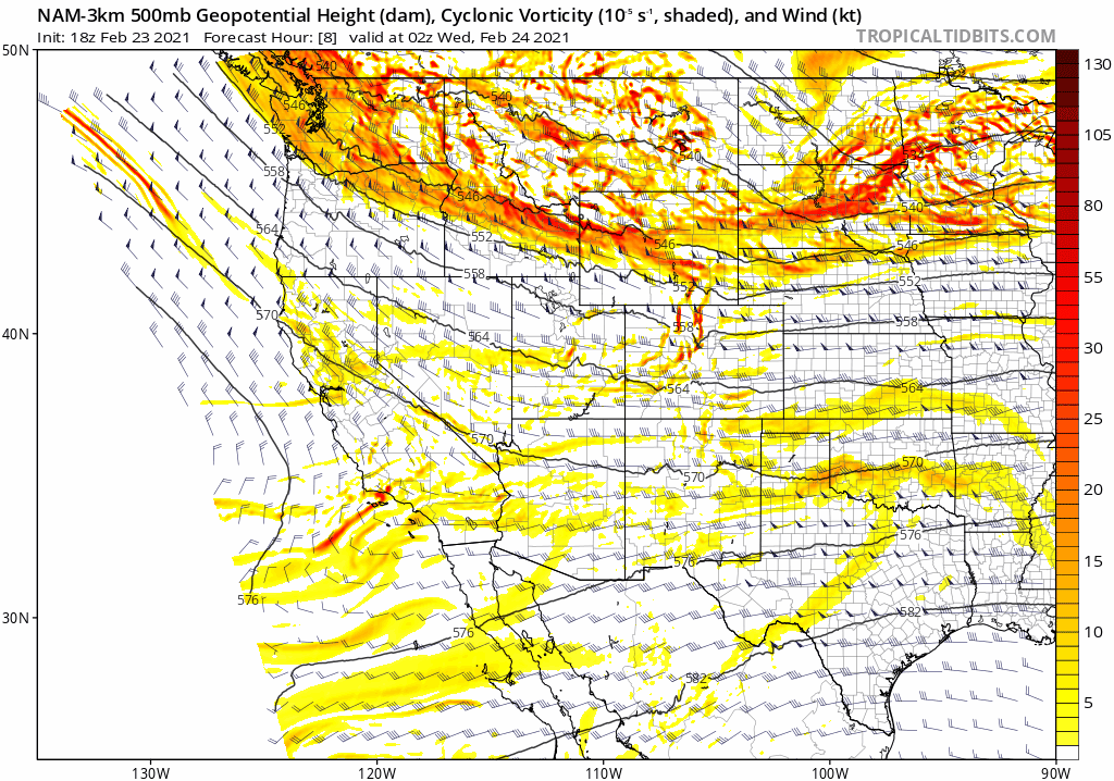
Here’s a look at the latest from the GFS and NAM models. As was the case yesterday, the GFS is still the most bullish model of them all, though it has come back closer to reality today. The NAM remains fairly consistent over its last handful of runs, and actually agrees quite well with the Euro model (not shown).

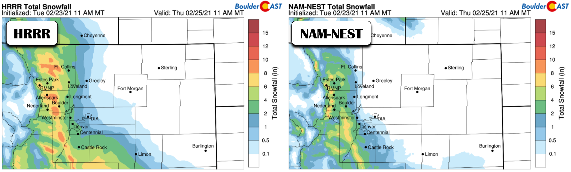
The higher-resolution weather models shown below paint a very similar picture, though even they cannot agree fully on where and how strong the east-west gradient in snowfall will be across the Denver Metro area. However, it’s crystal clear that there will be a strong gradient. Fun times!
Timeline & Amounts
Expect light snow to start developing first in the Foothills of Larimer County as low-level moisture increases Wednesday afternoon under southeasterly upslope. Snow will spread southward into the western Metro area through the early evening. It may take until the mid-evening (or even late evening) for snow to begin falling in the heart of Denver and areas east. The most widespread and heavy snowfall will line up right along the Foothills, in places like Boulder, Golden and Littleton.
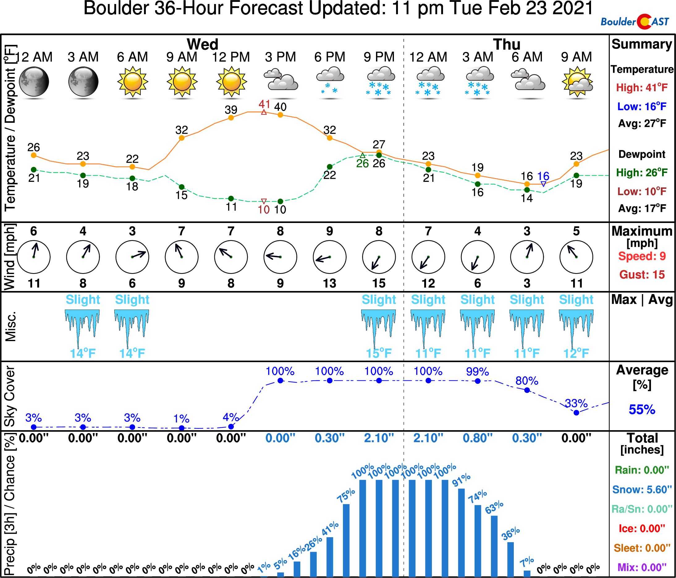
This type of upslope will greatly favor these western suburbs, as well as the Foothills below 8000 feet elevation. In these areas we are predicting anywhere from 4 to 8″ of snow. There could be localized totals right along the interface with the terrain that see up to 12″. Boulder would be a good candidate for this localization, but it’s definitely a stretch to see those type of totals. The anticipated sharp snowfall gradient will see amounts drop dramatically heading east away from the terrain. Denver International Airport could very well see next to no snow from this storm.
Our snowfall forecast map for the event is shown below. This covers snow falling Wednesday afternoon through Thursday afternoon.

All in all, we’re dealing with a somewhat challenging forecast. The fine-scale, exclusively terrain-forced nature of this event will likely leave some of you disappointed. Time will tell exactly who that is, though. With a slew of more up-to-date model runs between now and the first snowflakes, we’ll continue to evaluate the situation and shoot out another update on Wednesday if needed. We’ll be doing our best snow dance tonight. Feel free to join in…
Get BoulderCAST weather updates delivered to your inbox!
We respect your privacy. You can unsubscribe at any time.
Help support our team of Front Range weather bloggers by joining BoulderCASTPremium. We talk Boulder and Denver weather every single day. Sign up now to get access to our daily forecast discussions each morning, complete six-day skiing and hiking forecasts powered by machine learning, first-class access to all our Colorado-centric high-resolution weather graphics, bonus storm updates and much more! Or not, we just appreciate your readership!
.
Spread the word, share the BoulderCAST forecast:
.


You must be logged in to post a comment.