The nicest weather in nearly three weeks will unfold Monday and Tuesday, but snow is just a few days away! Yet another wintry system with an unfavorable track will impact the area Wednesday evening into Thursday bringing widespread upslope snow to the Front Range. We’re also watching the potential for a more significant winter storm during the upcoming weekend, but uncertainty remains this far out. Read on for our complete outlook of the week ahead.
This week’s highlights include:
- Mild and breezy Monday and Tuesday in the 50’s as dry northwest flow and high pressure stay in control
- A dry cold front arrives late Tuesday knocking temperatures back down for Wednesday
- Our next storm system arrives Wednesday evening with widespread upslope snow expected across the Front Range
- The pattern remains active into the weekend with cool temperatures and more snow on the table

DISCLAIMER: This weekly outlook forecast is created Monday morning and covers the entire upcoming week. Accuracy will decrease as the week progresses as this post is NOT updated. To receive daily updated forecasts from our team, subscribe to BoulderCAST Premium.

Milder Monday & Tuesday
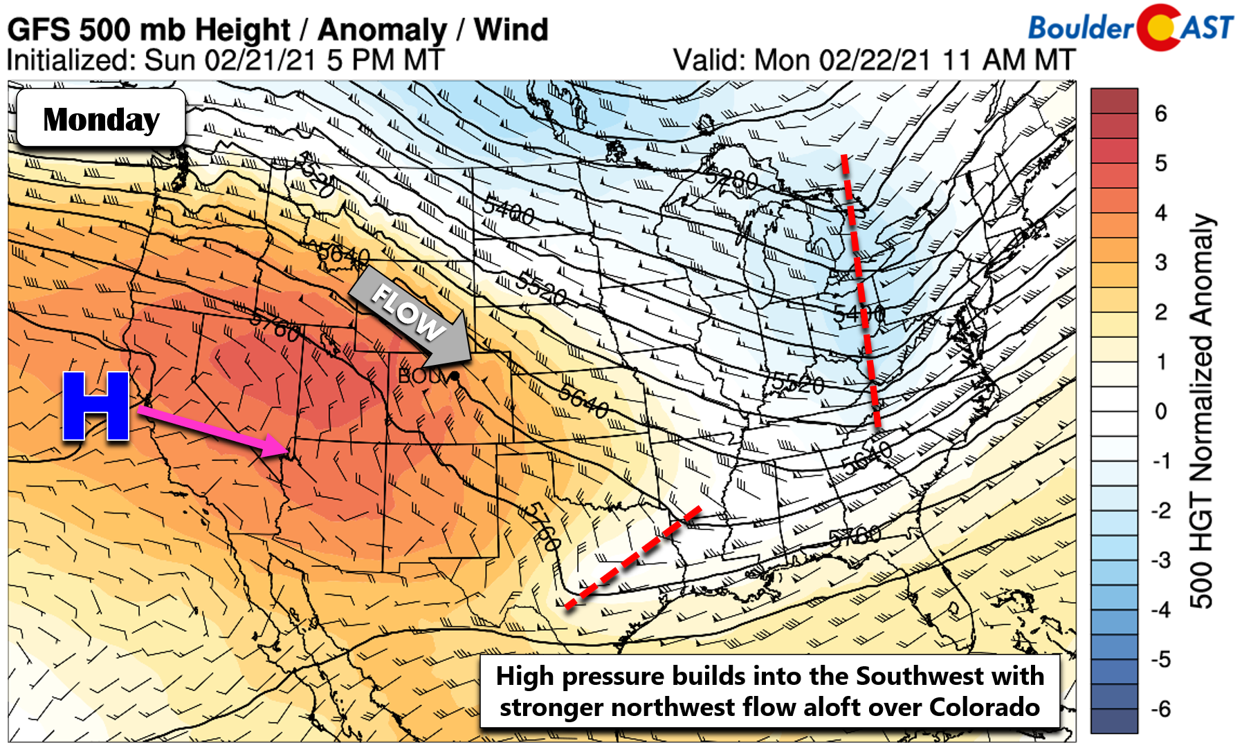
The best weather days this week will occur right at the start as high pressure builds in across the southwestern United States. Initially on Monday, a somewhat tight height gradient exists over Colorado with northwest flow aloft. This will produce gusty winds in and near the Foothills of 20 to 40 MPH, with up to 65MPH in the Mountain ridges. Heading away from the terrain, the winds will be lighter. Things quiet down wind-wise late Tuesday and beyond.
GOES-East satellite imagery shows us the broad clockwise flow around the high pressure off the California coastline as of Monday morning. There are some pockets of clouds upstream, but there will be plenty of sun in the Front Range early this week.

GOES-East infrared satellite animation from Monday morning
Accompanying the high pressure will be warmer temperatures. Northwest flow from the Pacific doesn’t generally produce warm weather for us, unless it is ousting a colder Canadian airmass. Comparatively, yes this northwest flow will produce a welcomed warmer period early this week. Temperatures both Monday and Tuesday will get into the middle 50’s.
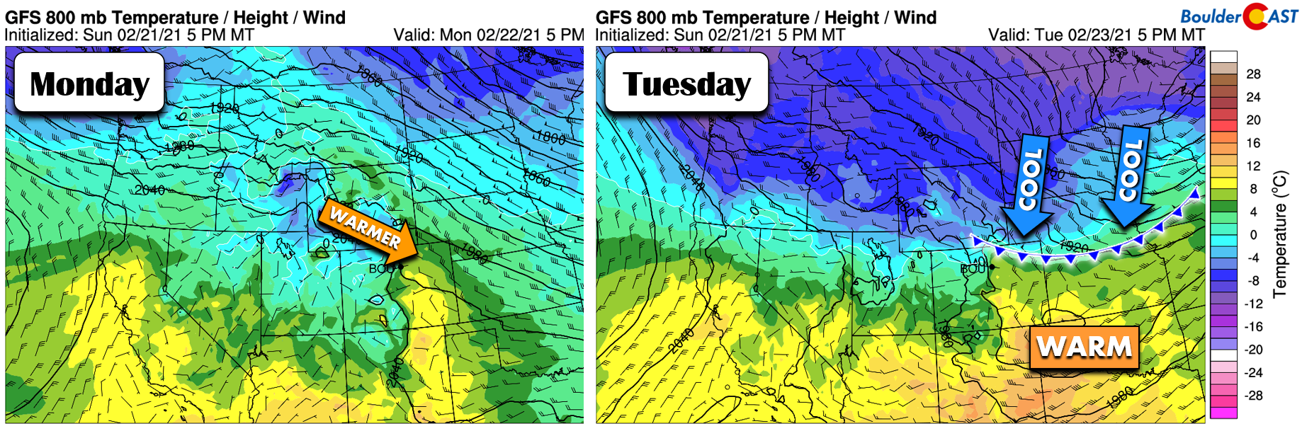
However, by late Tuesday, a weak clipper system will be moving across North Dakota and a trailing cold front will be knocking on our door. This is shown in the right panel above. The current timing has this front moving through the Denver Metro area Tuesday evening. Moisture will be too scant with this setup and the Mountains and Plains will remain dry.
Snow returns Wednesday evening
Wednesday will be largely dry, but significantly colder following the passage of the front the evening prior. High temperatures Wednesday will fall back into the low to middle 30’s, well below normal for late February.
Our first chance of snow for the week ahead begins to take shape late in the day Wednesday as the next shortwave system digs into the Four Corners region. The 500mb vorticity forecast animation below shows the system moving from Idaho Wednesday morning into New Mexico by Thursday morning. This is more-or-less an identical path to our last ten or so snow events across the Front Range. Thus, you know this is not a great track for us, but we’ll probably still squeak out some underwhelming amount of light snow anyways.
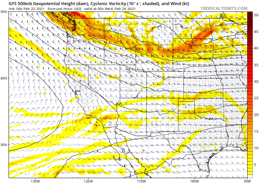
With most of the energy from the mid-week system skirting too far south and west again and no favorable jet dynamics to fill the gap this time, the focus to force any snowfall shifts to upslope which does appear to be decent Wednesday night. Models are consistently indicating 10 to 15 MPH upslope from the surface to the top of Continental Divide. This setup could produce sizable snowfall totals along the terrain west of Denver.

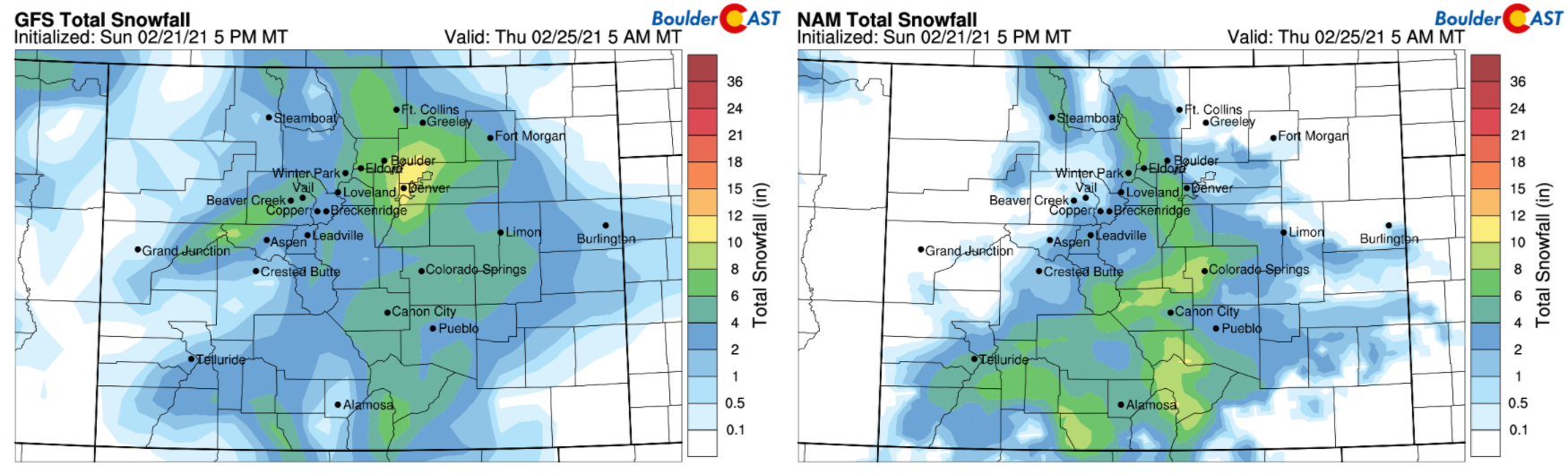
There is a lot of variation in the models right now in regards to potential snowfall amounts for us. There is still some movement in the track of the parent storm system, which is certainly playing a role in how the wind fields interact with the terrain across the Front Range. The GFS, shown below on the left, is one of the more bullish models at this juncture for snow with a “big snowy bullseye” right over the Denver Metro area (almost a foot!). The NAM (below on the right) and Euro models are more modest and likely more reasonable with snow amounts, producing 3-7″ of snow in the western portions of Denver, including Boulder….with lesser amounts east of Interstate 25.
With that said, plan on widespread light snow developing late Wednesday afternoon or evening as the upslope intensifies, continuing through the overnight into Thursday morning. The heaviest of the snow would likely occur Wednesday evening and night in and near the Foothills. Light snow will be winding down Thursday morning with winds turning to downslope and skies clearing. Highs Thursday stay in the 30’s.

By Friday, we’ll be in between storm systems with zonal flow for the most part. Highs creep back into the 40’s across the Front Range. Overall, the unsettled pattern will return into the weekend. Another storm is progged to move into the Rockies or Four Corners area on Saturday, with outcomes still quite variable. On paper, this system should offer another chance of snow for our area taking a similar track. However, some models are trying to develop a cut-off low somewhere in Arizona over the weekend with could be a major player for us. While this is intriguing, it’s still likely a fantasy being so far out in the models. We will certainly be keeping an eye on this system as it would have the potential to tap into warmer, more moisture rich Gulf of Mexico air. For now, plan on a chance of snow late Saturday and Sunday with temperatures trending downward.

Forecast Specifics:
Monday: A few wave clouds here and there. Otherwise, mostly sunny, mild and breezy with gusts of 20 to 40 MPH through the day. Highs in the middle 50’s on the Plains and lower 40’s in the Foothills.
Tuesday: Partly cloudy, mild and breezy with gusts up to 25 MPH. Highs in the middle 50’s on the Plains, but falling behind a cold front that arrives by early evening.
Wednesday: Colder with morning sun, but increasing clouds with widespread snow developing by evening. Snow could be heavy in and near the Foothills and will continue into early Thursday. Highs in the low to middle 30’s on the Plains and in the middle 20’s in the Foothills.
Thursday: Morning clouds and light snow linger, but skies clear through the day. Preliminary snowfall expectations are 2-6″, but this is still uncertain. Temperatures stay in the low to middle 30’s across the Plains and in the lower 20’s in the Foothills.
Friday: Mostly sunny and dry with highs in the lower to middle 40’s on the Plains and upper 20’s in the Foothills.
Weekend: Unsettled weather continues into the weekend with another system moving towards Colorado on Saturday. Models vary on where this storm goes and how it evolves, but some indication has a cut-off low forming to our southwest which is something to watch. Expect highs in the 40’s Saturday and 30’s (or 20’s) Sunday with light snow chances backloaded in the weekend.
Mountains: The Mountains will see windy but largely sunny conditions on Monday and Tuesday, especially above treeline as dry northwest flow hammers the state. Areas east of the Continental Divide will see the most upslope snow Wednesday into Thursday, as well as the San Juans which will be closer to the parent low pressure. Widespread snow returns to much of the state’s Mountains this weekend as the next, potentially slower-moving storm system arrives. We’re still not yet seeing any massive dumpings of powder, though.

Help support our team of Front Range weather bloggers by joining BoulderCAST Premium. We talk Boulder and Denver weather every single day. Sign up now to get access to our daily forecast discussions each morning, complete six-day skiing and hiking forecasts powered by machine learning, first-class access to all our Colorado-centric high-resolution weather graphics, bonus storm updates and much more! Or not, we just appreciate your readership!
.
Spread the word, share the BoulderCAST forecast!
.


You must be logged in to post a comment.