Another day, another chance of light snow. The theme of this winter continues as a weak storm system blazes across Colorado Saturday evening bringing a chance of snow to the region. We’ve got some jet-forcing to deal with this time, so localized bands of heavy snow are possible, but our forecast keeps most of these south and east of Denver. Let’s take a look at the timing and snowfall amounts!
At a Glance:
- Another quick-hitting storm system blows across Colorado Saturday evening
- Weak jet-forcing, frontal lift and some upslope combine briefly before downslope dashes any remaining hopes of accumulating snow
- Spotty rain changing to snow between 5PM and midnight Saturday evening
- Up to 3″ of accumulation possible, but north and west of Denver could see nothing
- Cool but pleasant on Sunday with a warming trend anticipated for the start of the week
Help support our team of Front Range weather bloggers by joining BoulderCAST Premium. We talk Boulder and Denver weather every single day. Sign up now to get access to our daily forecast discussions each morning, complete six-day skiing and hiking forecasts powered by machine learning, first-class access to all our Colorado-centric high-resolution weather graphics, bonus storm updates and much more! Or not, we just appreciate your readership!

A quick-hitter
Another quick-moving and ultimately weak storm system is prepping to move across Colorado Saturday evening into the night. The GOES-East infrared satellite animation below from early Saturday morning shows that the approaching storm system is currently located near Lake Tahoe in the Sierras.
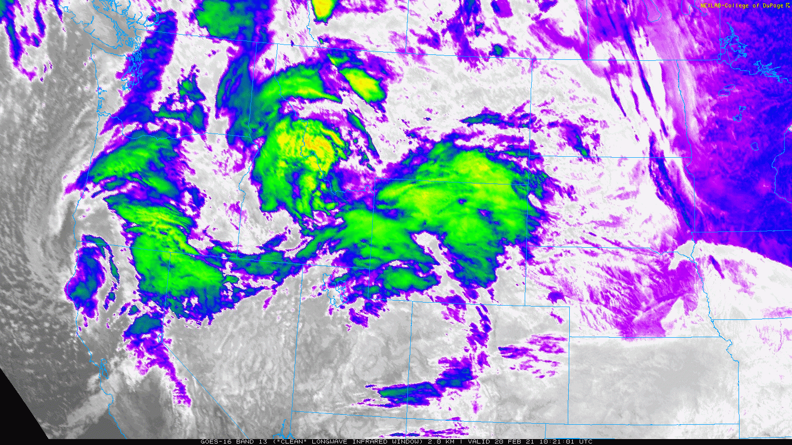
GOES-East infrared satellite animation from Saturday morning
The NAM model forecast animation below at 500mb brings this storm through the Four Corners and across extreme southern Colorado Saturday night. This isn’t usually a bad track for us, but this storm is progressive (i.e. it’s moving fast) and has a very positive tilt. That is, its axis is steeply oriented southwest to northeast. We like to have this axis oriented more north-south to get better wind fields for upslope in the Front Range.
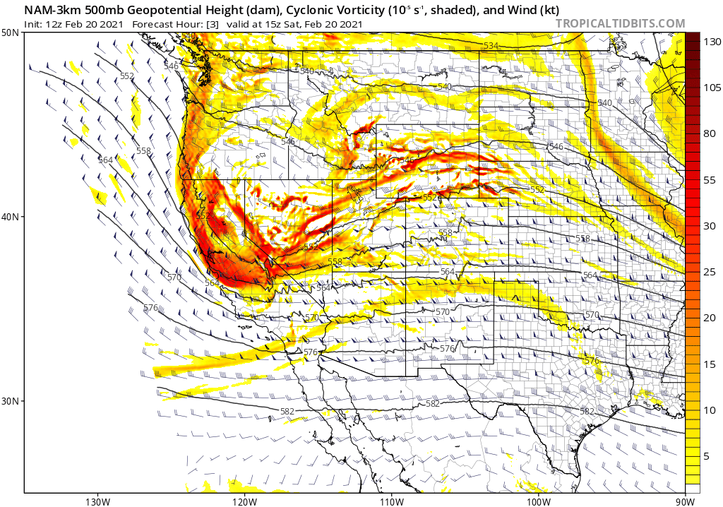
It’s this combination of extreme brevity and trough orientation that will greatly limit this storm’s impact for us with downslope sweeping across the Denver Metro area quickly tonight killing off any snow chances not long after they begin. Tonight’s happenings are actually quite similar to a jet-forced event that brought a localized wave of heavy snowfall to the southern Metro back in the beginning of February.
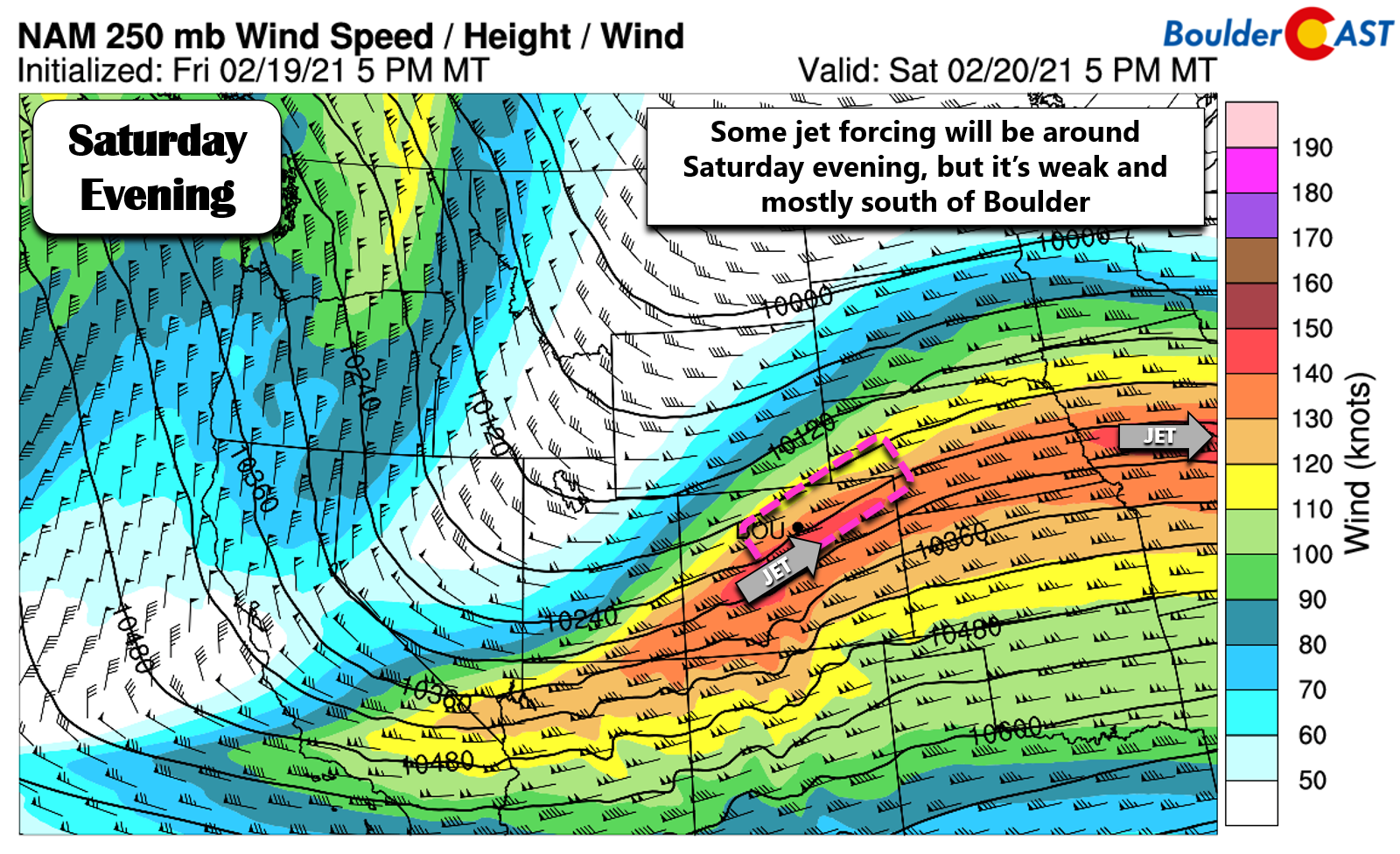
Shown below is the jet-level wind forecast for Saturday evening. While it can be argued that northeast Colorado will be in the favorable left-exit region of a small jet-streak, this particular jet streak is not very potent. We like to see a nice bullseye of strong winds making up the streak, both along and across the flow. In this case, there’s not much of an along-flow gradient which is the key for jet-forcing.
As the cold front moves through Saturday evening, there will be a brief window where frontal convergence, meager upslope and spotty lift from the weak jet streak will combine to produce a few rain and snow showers across the Metro area. All of the weather models indicate linear bands of precipitation this evening, perhaps hinting that the aforementioned jet may be a little more important than first glance. However, as we expect, the target for these bands is primarily across southern Denver and the Palmer Divide,
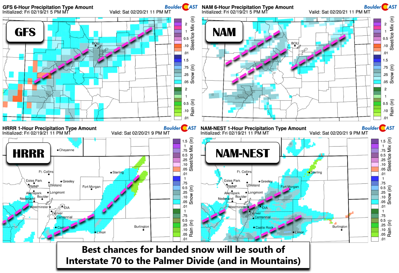
As always, pinpointing the exact location of these banded features will be tricky this evening. Our gut feeling, which by the way is backed-up by the higher-resolution models, tells us they will mainly be south of Interstate 70 through the Palmer Divide. These areas shall be last to get swept into the downslope regime this evening which gives them the best chance at accumulating snow. However, the global models like the GFS and Euro, show Boulder and downtown Denver possibly getting in on the action as well, so things are still a little murky.
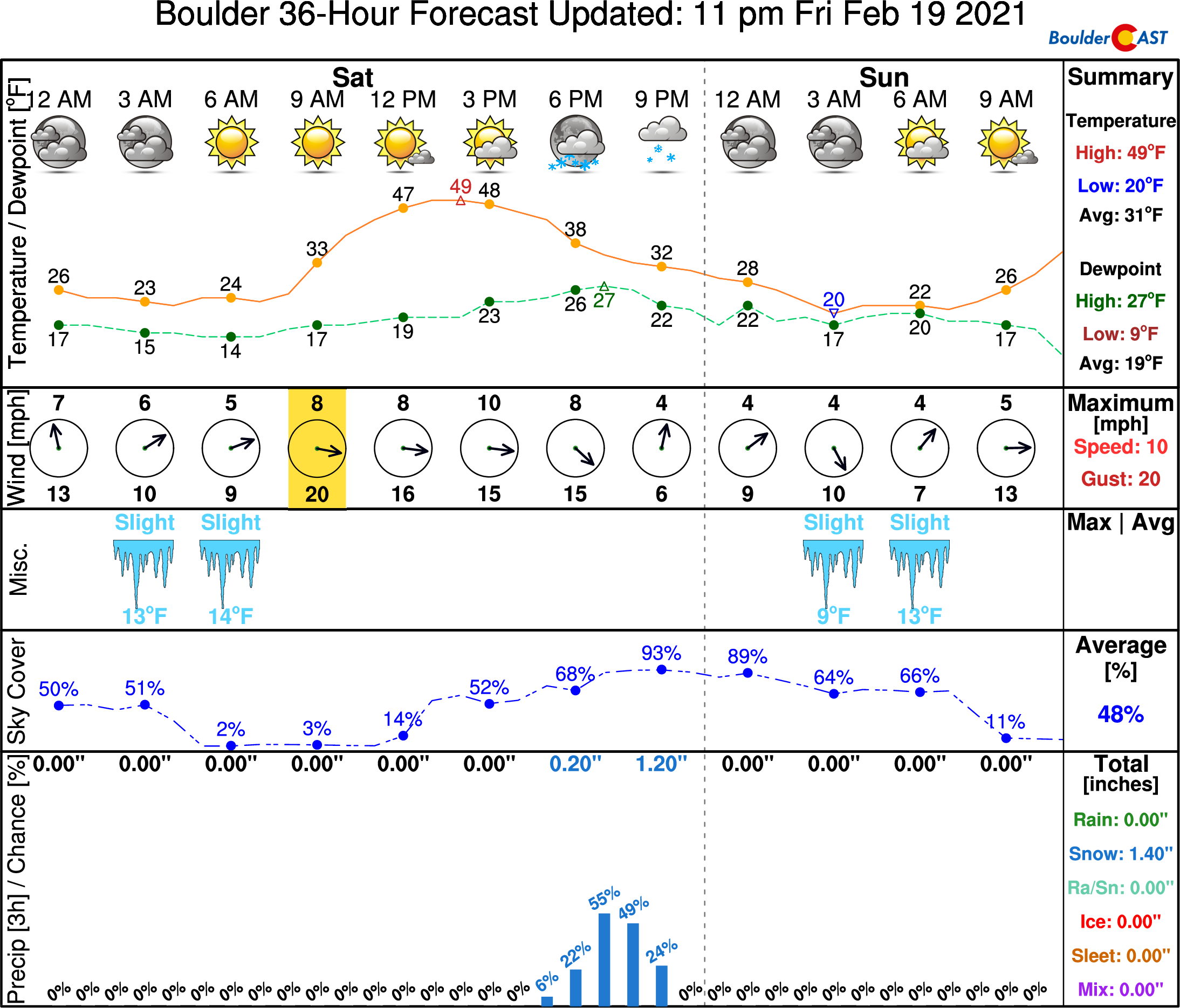
Much of early Saturday will be quite sunny across the area, but clouds will increase through the afternoon ahead of the storm system with moisture increasing aloft. It will be warm enough this afternoon (mid to upper 40’s) that the first bouts of precipitation will likely be raindrops before quickly changing over to snow through the evening. The primary window for any precipitation will be from 5:00 PM until midnight Saturday evening. Precipitation will arrive and depart northwestern suburbs and Boulder in the early part of this window, then lingering longest southeast of Denver.
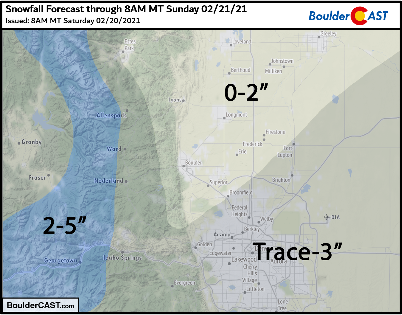
Our snowfall forecast map for the event is shown below. This covers all snow falling through Saturday night. The best chance at accumulation will be across the southern and southeastern tier of the Denver Metro area and in the higher Foothills which could see up to 3″. Areas along the northern Front Range may not see any snow at all with downslope taking over quickly and the bands developing too far south.
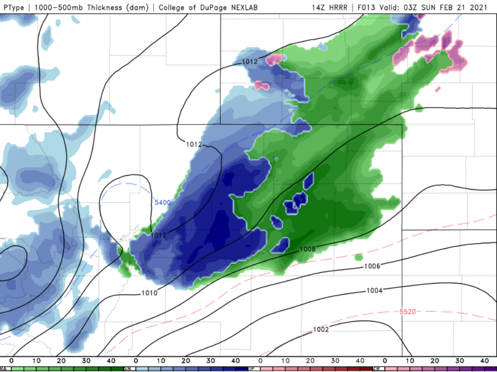
Travel impacts will be limited to the core of any heavy snow bands that may develop this evening. Elsewhere, snow will be too spotty and light to stick on roadways which were basking in the warm sun most of the day. As of writing, the latest run of the HRRR model spawns a pretty nasty snow band from central Denver out eastward across the Plains around 7:00 or 8:00PM this evening. Travel within this area could be slick. Just be aware of the potential for deteriorating conditions this evening, especially south and east of Denver.
Sunday will be cooler but sunny with highs staying below seasonal norms around 40 degrees. However, warmer temperatures will flood the area for the early part of the work week ahead. We’ll discuss this and more in our weekly outlook on Monday. Have a good rest of the weekend!
Get BoulderCAST weather updates delivered to your inbox!
We respect your privacy. You can unsubscribe at any time.
Help support our team of Front Range weather bloggers by joining BoulderCASTPremium. We talk Boulder and Denver weather every single day. Sign up now to get access to our daily forecast discussions each morning, complete six-day skiing and hiking forecasts powered by machine learning, first-class access to all our Colorado-centric high-resolution weather graphics, bonus storm updates and much more! Or not, we just appreciate your readership!
.
Spread the word, share the BoulderCAST forecast:
.


You must be logged in to post a comment.