The Veterans Day 2018 snowstorm delivered a bigger punch than forecast across portions of the Denver Metro area. We review the evolution of the storm and discuss why snow totals came in so unexpectedly high.
We had been discussing the Veterans Day snow event with our Premium members since last Wednesday, five days in advance. The storm had all the makings of being a run-of-the-mill light snow event for the Front Range. That is, a relatively weak storm system embedded in the northwest flow, one which had plenty of cold air and upslope, but ultimately was going to be hobbled by a less-than-ideal track and quick progression across Colorado. This was the case all the way into Friday when we issued our preliminary forecast.
However, in the 24 hours leading up to the storm’s arrival, we started to see a shift in the models. Precipitation amounts began to creep up across our entire region, which is ultimately what prompted us to issue a forecast update Saturday afternoon, bumping up snowfall amounts region-wide. While we took a somewhat conservative approach overall, there was clear indication that totals could blow past our forecast. We specifically mentioned that “it is almost a certainty that Boulder will see at least 4″ and Denver at least 2″. This storm is one where if there is a busted forecast at all, it will be higher not lower!”
Shown below is our snowfall forecast map (issued Saturday afternoon), with the observed storm totals per location contained in boxes. Green ones indicate that the observed snowfall was within one inch of the given forecast range, while red was outside the scope of our forecast.

Wouldn’t you have guessed, the storm busted high, mainly in eastern Boulder County, where anywhere from 8 to 14″ of snow fell. We haven’t received updated totals following the final flakes that dusted the region Monday morning around rush hour. However, before this brief activity, the official total in Boulder was 13.4″ and in Denver was 1.8″. The 12.4″ of snow that fell on Veterans Day itself was a new daily record in Boulder.

NOHRSC interpolated snowfall analysis for the event
Boulder’s seasonal snow total now sits at 24.0″ while Denver has recorded 5.0″.
Why the bust in Boulder?
We haven’t had a forecast tank this bad in Boulder since the “surprise” snowstorm back in December of 2015. Everything we discussed in our Saturday update was valid and played a role, but even-more-so than anyone expected.
The key factor here lies in why the models ramped-up precipitation amounts so substantially as the storm approached. Model QPF increased in Boulder from 0.2″ on Friday, to 0.35″ by Saturday morning, to 0.6″ or more Saturday night. A factor of three increase in 24 hours!
Unlike the quick-moving open-wave disturbance indicated in forecasts the day before (below on left), the storm actually came in much stronger, further west, and nearly cut-off at 500 mb (below on right). This structure put the Front Range in a much more developed upslope regime for an extended period of time.
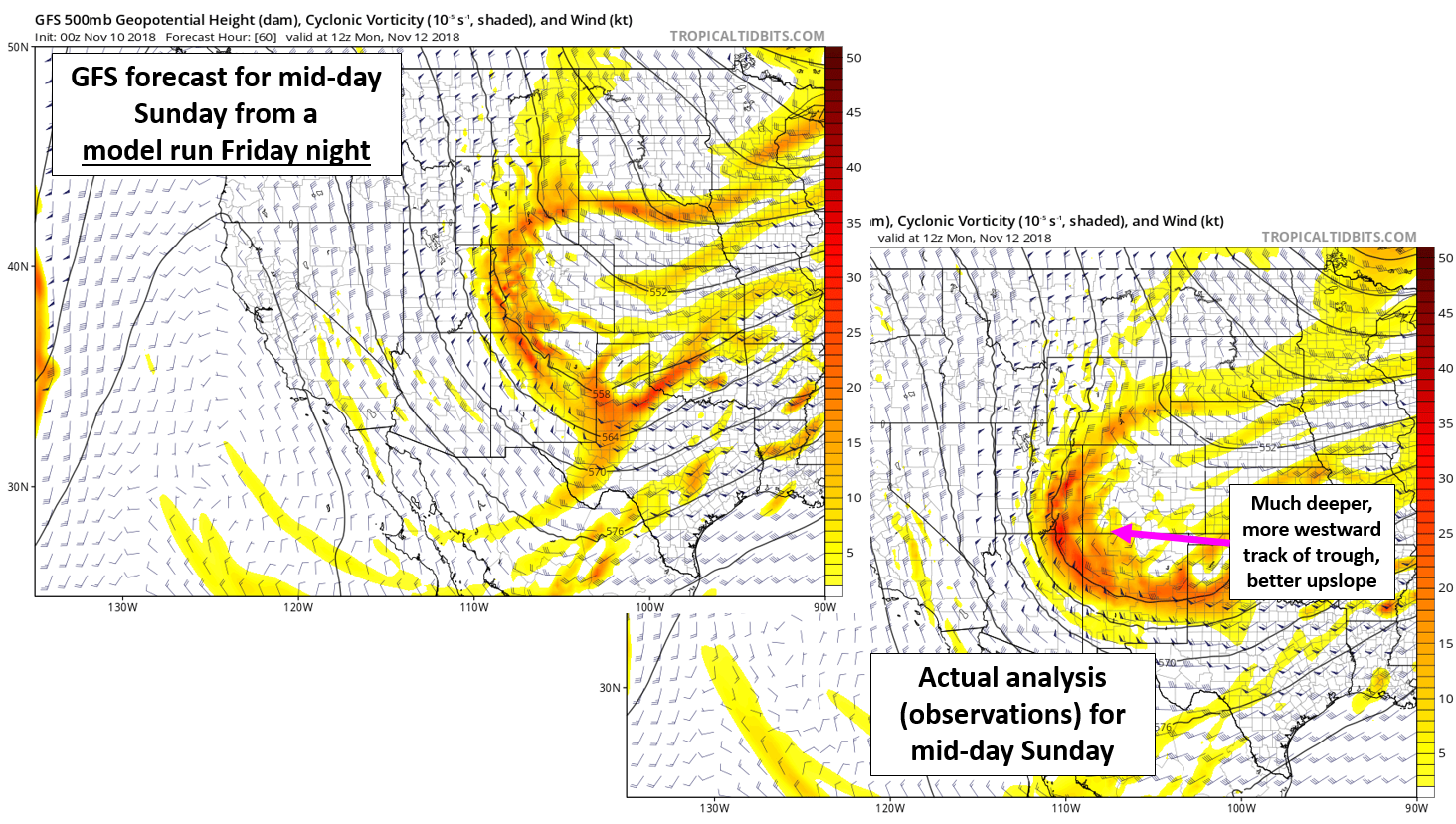
GFS 500 mb height and vorticity forecast for Sunday (left) and the observed (analysis) right.
If we take a look at the observations from NOAA’s wind profiling radar in Platteville (30 miles northeast of Boulder), we see an long period of low-level upslope present from Saturday evening all the way into Sunday night. This graph is a little confusing in that time progresses from right to left, so keep that in mind. We have boxed in pink the period of time from 12:00 AM to 6:00 PM Saturday. This included a bulk of the snow event. Notice that the cap in the upslope layer was at 2800 meters, or around 9200 feet elevation. That northeasterly upslope at 7500 elevation, surging to 15 knots during the peak of the snow (regions circled in red), was perfect wind flow for snow in Boulder and the nearby Foothills below 8000 feet.

Wind profile data for the event
If we take a look at radar stills from the times coinciding with the two red circles in the profiler data above, it’s easy to pick out the localized topographic enhancement paralleling for Front Range Foothills. This enhancement led to snowfall rates of 1″ per hour much of Sunday morning over the eastern half of Boulder County. Snow totals were maximized right along the interface between the Plains and the Foothills, right over Boulder. Higher elevation areas along Peak-to-Peak highway still saw impressive snow totals, but actually were above the strongest upslope and only recorded 5 to 9″ of snow.

Radar captures from Sunday morning showing the localized snowfall enhancement right along the Foothills
As the winds aloft backed to northerly and even northwesterly late Sunday afternoon, snow mostly tapered off across the Metro area. You can see this clear wind shift around 3:00 PM in the observations from BoulderCAST Station on Sunday:

BoulderCAST Station weather graph for Sunday.
A secondary, much weaker piece of energy merged southward across Colorado late Sunday night and Monday morning leading to a few brief bursts of snow and 1 to 2″ of additional accumulation in some locations.
Usually we can blame most of our snowfall forecasting mishaps on the overhead jet stream, but the jet was not a player at all this time. It all came down to the models not capturing the track and intensity as well as they needed to. Upslope was stronger and the storm lasted longer leading to more precipitation overall in areas right along the Foothills. Furthermore, magnifying this precipitation discrepancy were giant snow to liquid ratios. For example, the snow ratio in Boulder for the entire event was 20:1 (13.4″ snow / 0.68″ melted liquid), exceptionally high for November. These two facets together led to a major bust in the Boulder area, despite our forecast turning our well for a bulk of the Denver Metro area.
Looking back at things, our measly 3-7″ forecast in Boulder seems a bit comical, but you know what they say about hindsight. As we have discussed time and time again, forecasting snow in the Front Range can be a colossal challenge at times as minor shifts in track can make or break any storm due to our topography. It just so happens this time around, it MADE the storm.
Share this storm recap & let us know your snow total in the comments:
.


You must be logged in to post a comment.