Wednesday’s winter storm was a typical one for the Front Range. We discuss the snow totals, the lack of blizzard conditions, and whether or not it was a bomb cyclone.
Storm recap: ‘Twas not a blizzard
Wednesday’s winter storm shared a lot of similarities with the major blizzard that impacted the Front Range back in mid-March. However, it clearly was an entirely different beast with just as many, if not more, dissimilarities. Unfortunately, the media focused too heavily on the shared traits which had many people believing we were in for another blizzard-inducing MEGA bomb cyclone.
We rarely toot our own horn, but if you’re a BoulderCAST reader, the weather that transpired on Wednesday should have fallen closely in-line within your expectations. From our cautiously-optimistic weekly outlook on Monday, to our daily Premium forecast discussions, we stressed that this storm was going to play out much differently than the last. The storm was weaker overall, and the high wind potential was thus lower, and so too the travel impacts and chances for any power outages…
Peak wind gusts on Wednesday during the storm barely reached 35 mph in the Denver Metro area (see below). We did observe a good deal of drifting snow, and possibility even a few instances of blowing snow. From my time as a surface weather observer in Greenland, trust me that there is a difference between the two! There was, however, nothing that came close to blizzard criteria.

The Blizzard Warning for the Denver area from the National Weather Service was probably issued just a little too early (Tuesday morning). At that time, models were still torn between borderline blizzard conditions and just a regular old breezy day. Later Tuesday and early Wednesday, it was clear that winds wouldn’t approach blizzard levels for the Front Range. The models had come into much better agreement. That is, the very windy GFS came back in-line with the tamer Euro model. However, it was too late to do anything about it…the public messaging could not be changed nor the warnings cancelled.
Despite the overall sense of disappointment some folks may have, we still had ourselves a classic Front Range spring storm, with rain changing to snow, beneficial moisture inundating the region, and even some thunderstorms reported southeast of Denver. Liquid precipitation (rain and melted snow) amounts ranged from 0.5 to 1.0″ across northeast Colorado.

Storm precipitation totals across northeast Colorado
Shown below is our snowfall forecast map with storm totals overlaid in boxes. Green boxes indicate that our forecast verified to within one inch of the observed snowfall. Red did not. Just about all locations landed within the bounds of our snowfall forecast. The forecast turned out quite well for most everyone (except for the cattle in Greeley).
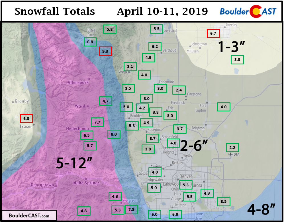
The official snow total in Boulder was 5.2″. The image below is from a CU Boulder early Thursday morning. This snow table had about 1″ of slush early Wednesday afternoon that fully melted during a lull in the action, then refilled with another 4″ Wednesday evening and night. Hey…1 + 4 = 5. Look at that!

CU Boulder snow table as of 7AM Thursday
Now for the 27th year in a row, Boulder has reported measurable snow in the month of April. Denver’s storm total was 2.2″ at DIA, though more like 3 to 5″ fell near Downtown.
The big winner for snow, the location that caught the “heavy convergence band” we referenced in our forecast, was north Loveland and Fort Collins (outside of our forecast domain). A very narrow band with snowfall rates of 1 to 2″ per hour lingered there for several hours Wednesday afternoon. Snow reports show 8 to 12″ of snowfall in this small area.

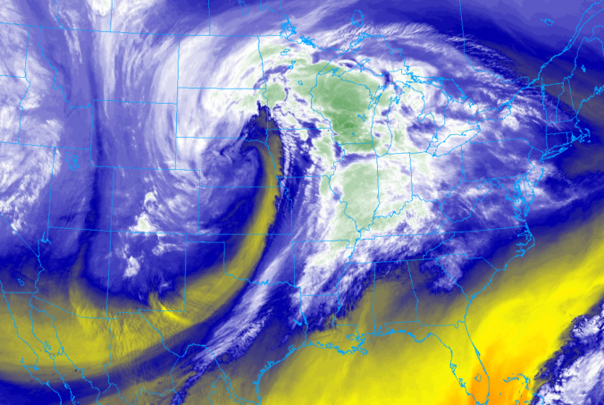
Radar image from noon on Wednesday (the onset of the rain/snow)
| Seasonal Snow Totals (Updated Apr 11 2019) |
|---|
| Boulder | Denver |
|---|---|
| 82.4" | 42.9" |

So was it actually a bomb cyclone?
Most accurately, no…it was not. But technically, kinda. Here’s the situation…
- The term bomb cyclone is what a storm that undergoes bombogenesis is called. Bombogenesis is the term for explosive intensification of a mid-latitude low pressure system.
- Both bomb cyclone and bombogenesis are very obscure meteorological terms that have been resurrected recently from the darkness of 1970’s research journals. When “blizzard” no longer gathers reader attention, “bomb cyclone” comes to the rescue…
- Bombogenesis was coined by one scientist from northern Europe in the 1970’s to describe extraordinarily rare and rapidly intensifying storms in the north Atlantic Ocean. He explicitly defined bombogenesis as a 24 millibar pressure drop in 24 hours. This is the accepted and widespread definition of bombogenesis, and the one the media has been using for the last five or more years any time a strong storm forms and they need that sweet, sweet ad-revenue.
- However, a few years later in 1980, two other scientists decided that bombogenesis criteria should vary by latitude (which does have the math to back it up). They created a bombogenesis equation that scales the established threshold (24 millibars) in relation to the original scientist’s latitude where he did his research (60 degrees north). The equation is… 24 mb x sin(latitude)/sin(60°). If we plug in the latitude of Boulder, 40 degrees, this equates to a bombogenesis threshold of 18 mb, instead of the “normal” 24 mb. That is, if a storm’s central pressure drops 18 mb in 24 hours near Boulder, that would be a bomb cyclone.
- This week’s storm seems to have dropped from about 1000 –> 982 mb in 24 hours. This does hit the 18 mb threshold, but not the 24 mb one. By conventional standards it wasn’t a bomb cyclone. However, by the latitude-adjusted equation, it was.
Has a can of worms been opened, paving the way for a much lower threshold for bomb cyclones to be named in the media? Yes…and this is undoubtedly a problem. While there may only be one or two powerful storms per year that reach the 24 mb bombogenesis threshold in the continental United States, there is probably a DOZEN or more that hit the latitude-adjusted threshold, which by the way varies from 11 mb in south Florida to 21 mb in Minnesota. Prepare yourself for the term “bomb cyclone” to appear in weather headlines on a semi-weekly basis next winter. Its original intention, as a term describing a rare atmospheric phenomenon, will surely become diluted in no time. We don’t have to look far for a prime example of another winter weather designation for which this fate has already overtaken: blizzard…
Share this post:
.


You must be logged in to post a comment.