This week’s snowstorm was definitely one to remember! We review the BIG snow totals and take a look at how the ingredients came together perfectly to produce the biggest and most widespread dumping of snow for our area in nearly four years.
I
n the days leading up to the storm this week, the bulk of weather models were consistently pointing towards significant snowfall potential in Denver, but beyond this, it was clear that borderline historic amounts were in the works for areas in and near the Foothills from Boulder to Fort Collins. By combining model data and our custom snowfall algorithms, forecast maps very similar to those below became commonplace up to four days ahead of time. These particular snowfall forecast maps shown below are from the GFS and NAM model runs Sunday evening (a full day of lead time): 12-18″ in Boulder with a downhill gradient in amounts towards Denver of 8-15″.
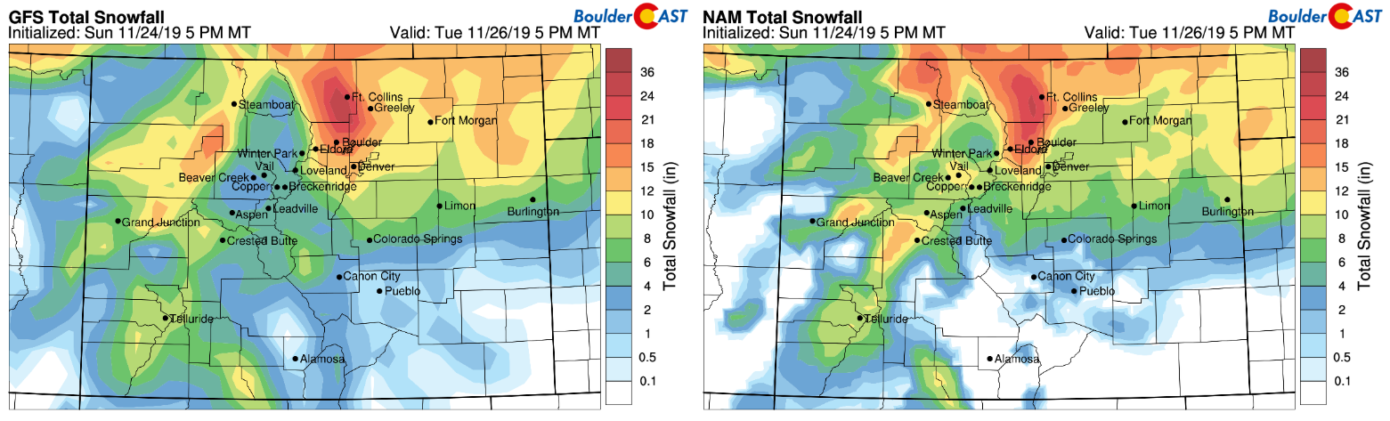
Model-derived snowfall forecast maps from the GFS (left) and NAM (right) models for this week’s BIG storm
As the storm approached, all of the major weather models were on-board for BIG snow, but their ensembles (both the GFS and Euro) were still coming in a little lighter. We posted our final forecast update early Monday morning urging everyone to brace for what was about to unfold. Some of the key messages from our forecast:
|
Right on schedule, an initial surge of heavy snow began to impact the area from Broomfield northward during the afternoon hours on Monday. Boulder already had 2″ on the ground by 6PM, while Denver largely remained snow-free. As the evening wore on, the mid-level over-running causing the initial heavy snow slowly edged south and east overtaking most of Denver. In the radar animation below, watch as the big blob of green heads down and to the right.
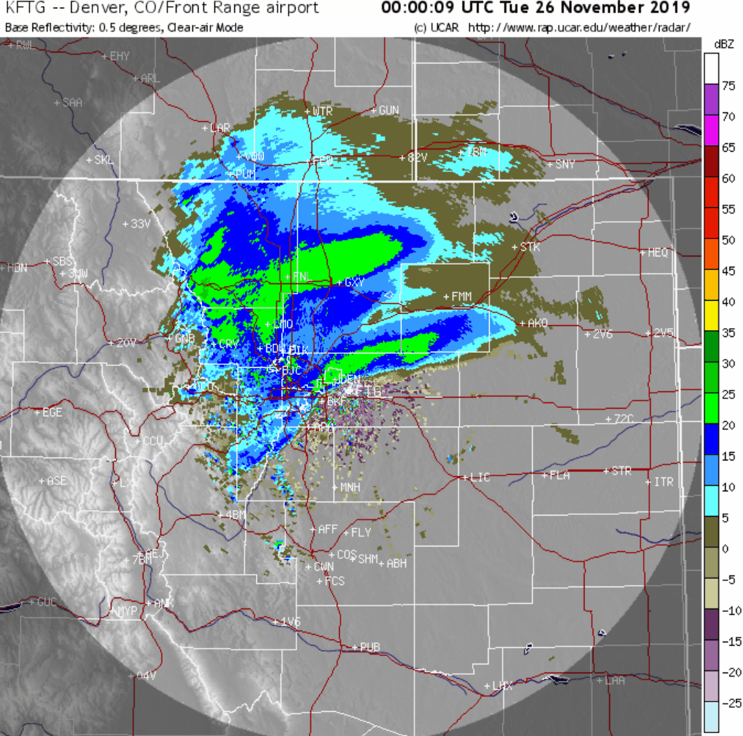
Denver Metro radar animation covering 5PM Monday to 5AM Tuesday.
As the first pocket of heavy snow exited to the east, an even more intense snow band developed during the wee-morning hours Tuesday. Snowfall rates of 2+” per hour were observed in the core of this secondary band (dark green in Boulder at the end of the animation above). Watch the heavy snow in action at CU Boulder before sunrise Tuesday:
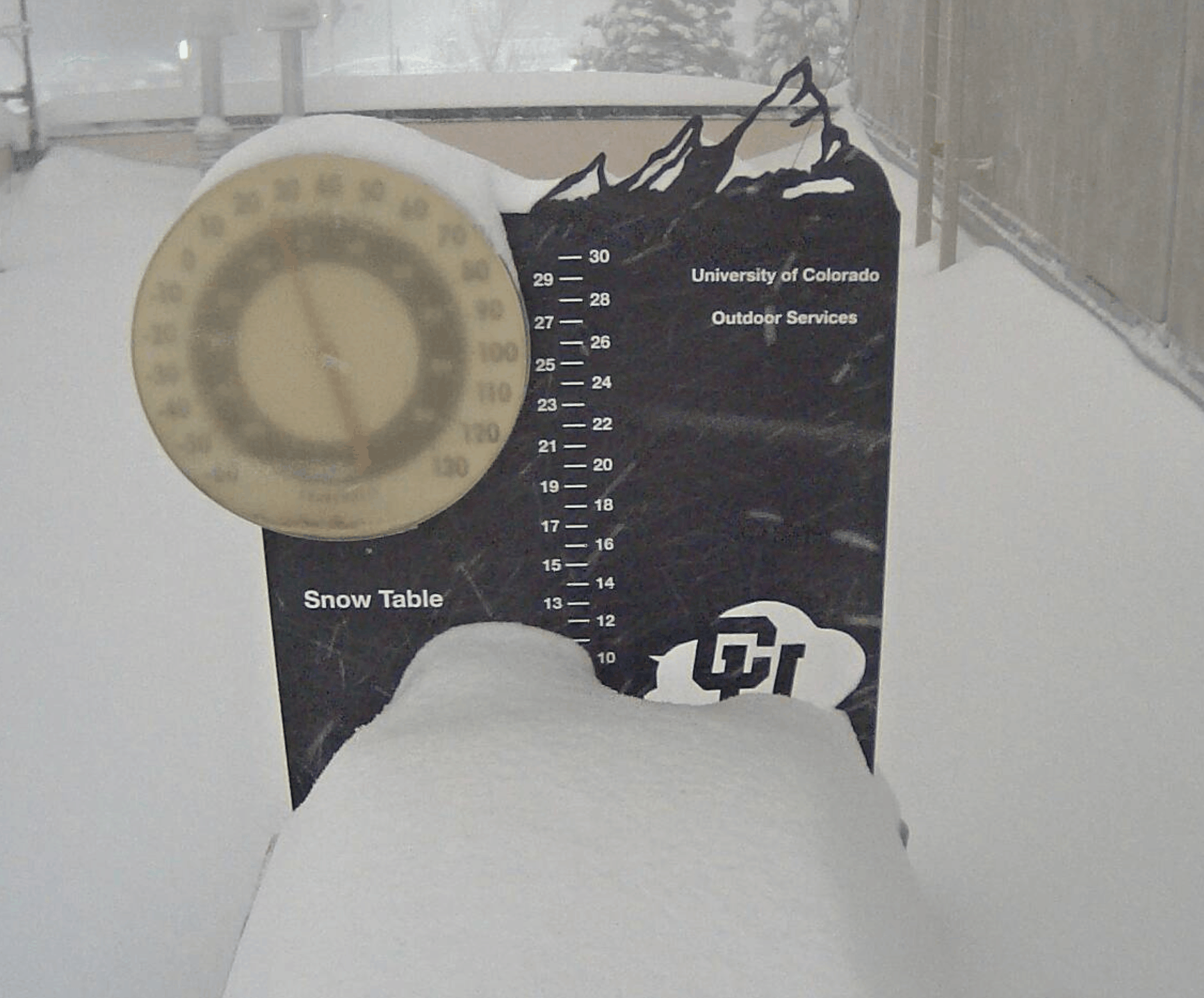
Video of heavy snow falling at CU Boulder, 5AM Tuesday
If we take a closer look at this secondary band, shown below on radar hammering Boulder at around 4:00 AM Tuesday, it’s clear what the primary forcing was: extreme upslope! We know this because the band is stationary and is oriented exactly parallel to the Foothills. The band was more than 100 miles long, but just 15 miles wide.

Denver area radar animation from before sunrise Tuesday morning
The brief but extreme upslope that ensued early Tuesday morning was always in the forecast and was a key reason we were so confident that Boulder, Loveland, and Fort Collins were going to be dumped on. As the vertically-stacked surface low intensified to our south, shown below centered near Colorado Springs, counter-clockwise flow to its north slammed into the terrain. This is upslope at its finest…due easterly and 30 to 40 mph a few thousand feet above ground-level!
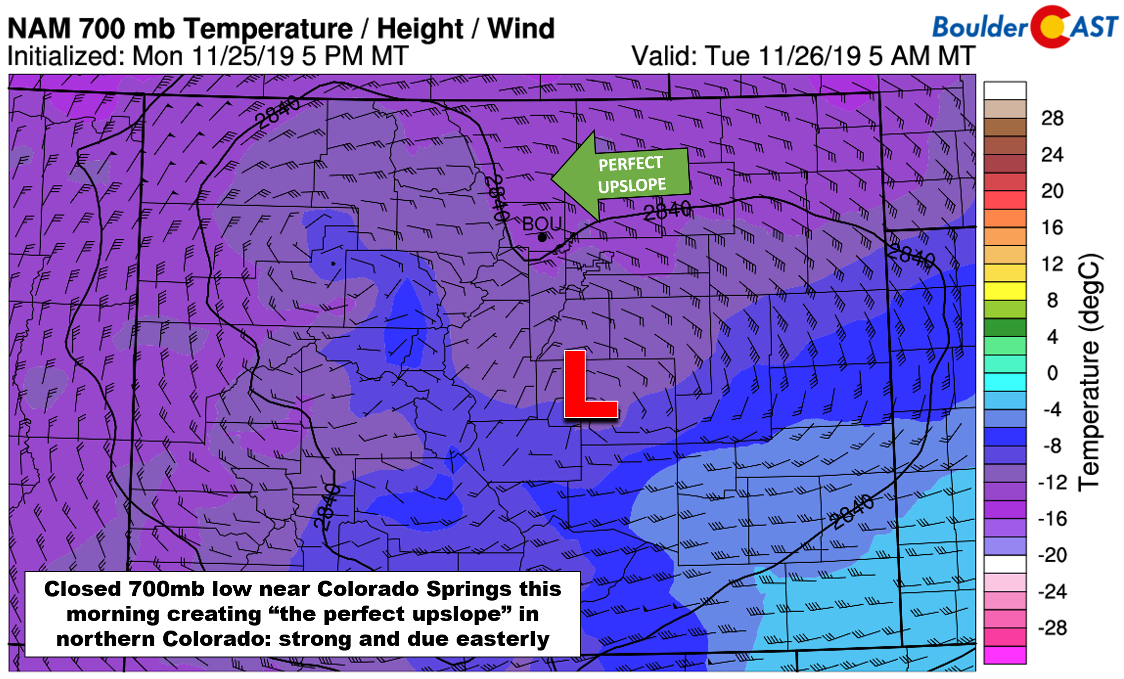
NAM 700 mb temperature and wind forecast for Tuesday morning
An infrared satellite animation from GOES-East is shown below. Can you pick out the intensifying low pressure in east-central Colorado Tuesday morning?
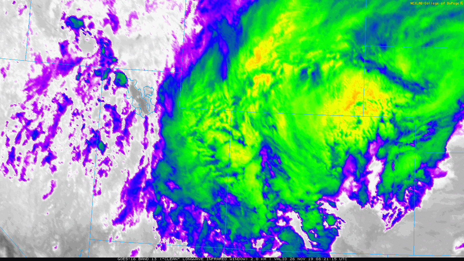
GOES-East infrared satellite animation from Tuesday morning
NOAA has a wind-profiling radar located about 25 miles north of Denver in Platteville. The data from the wind profiler, shown below, confirms the very strong and deep easterly upslope present in the atmosphere above the Front Range Tuesday morning. This is a time and height plot, with time increasing from right to left (it’s backwards…). The brief but intense upslope is highlighted in pink, beginning around 8 UTC (1:00 AM MT) and ending around 17 UTC (10:00 AM MT) Tuesday morning. We rarely see upslope this efficient in the Front Range, let alone have it last a solid nine hours!

For Boulder, about 40% of the total snowfall that occurred was associated with the initial wave, while the secondary upslope band produced the remaining 60% of accumulation. In Denver, it was about 80% then 20% as the upslope band never really pushed too far from the base of the Foothills.
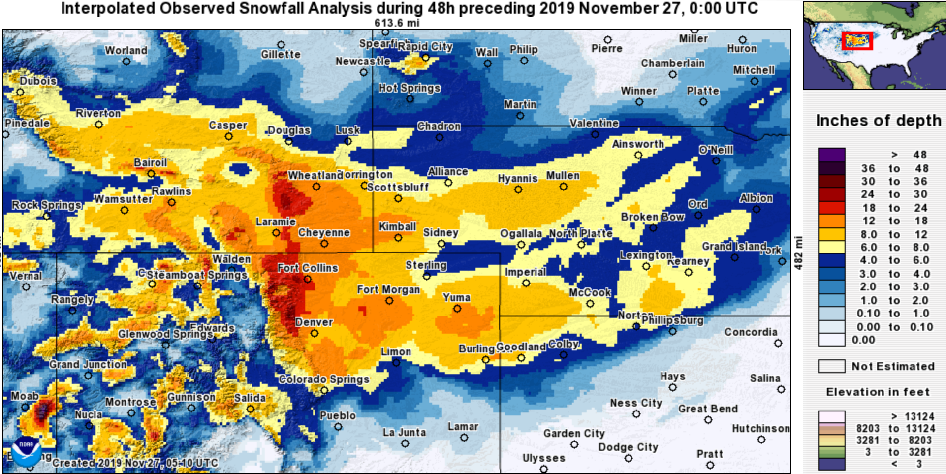
Interpolated snowfall observations from the event are shown below for the broader region (top) and Front Range (bottom). The heaviest snow was indeed aligned with our forecast and model projections.

Shown below is our snowfall forecast map issued early Monday morning with actual storm totals overlaid in boxes. Green boxes indicate that our forecast verified to within one inch of the observed snowfall. Red did not.

As expected, the greatest snowfall amounts were in Boulder and Larimer Counties where reports of 20 to 35″ were fairly widespread. For many Front Range cities, this was the biggest snow event in more than three and a half years. Yes…even bigger than both “Bomb Cyclones” last winter. For those cities that saw 20″ or more, this was the biggest storm in a nearly a decade.
Denver reported 9.5″ of snowfall officially at DIA, which by the way cancelled and delayed hundreds of flights on Tuesday. 22.5″ was the official snowfall total in Boulder. All of this fell in just about 20 hours. That’s nearly an average of 1″ per hour for a fully day! For a number of reasons, this was a historical event for B-Town:
- 11th largest snowstorm–Here’s all of them that produced at least 22″ in Boulder:
-
29.9″ 10/24/1997 –> 10/26/199726.0″ 4/7/1959 –> 4/11/1959 (likely was two storms)26.0″ 12/20/2006 –> 12/21/200625.9″ 3/29/1970 –> 3/31/197025.4″ 4/8/1959 –> 4/11/1959 (may have been two storms)24.0″ 11/20/1979 –> 11/21/197923.0″ 5/5/1978 –> 5/6/197823.0″ 10/28/2009 –> 10/29/200922.9″ 4/2/1957 –> 4/3/195722.7″ 2/3/2012 –> 2/4/201222.5″ 3/18/2003 –> 3/19/2003
22.5″ 11/25/2019 –> 11/26/2019
-
- 2nd largest November snowstorm
-
24.0″ 11/20/1979 –> 11/21/197922.5″ 11/25/2019 –> 11/26/201921.4″ 11/23/1992 –> 11/24/1992
20.1″ 10/30/1972 –> 11/1/1972
-
- 3rd highest single-day snowfall total (6PM to 6PM)
- 22.1″ 10/25/1997
- 22.0″ 11/20/1979
- 20.7″ 11/26/2019
- 20.6″ 4/2/1957
- 18.5″ 3/30/1970
- New daily snowfall record for November 26th
- 20.7″ (old record was 13.0″ from 1959)
- 2nd fastest to reach 50″ of cumulative snowfall in a season
- Oct 31 (1969)
- Nov 26 (2019)
- Dec 1 (1997)
- Dec 5 (2009)
- Dec 8 (1985)
NOTE: This historical context only applies back to ~1950 when reliable daily snowfall observations for Boulder became available. Storm totals were derived by summing consecutive days with reported snowfall.
Seasonal snow totals so far for Boulder and Denver are wildly above normal for late November.
| Seasonal Snow Totals (Updated Nov 27 2019) |
|---|
| Boulder | Denver |
|---|---|
| 55.1" | 25.7" |
We’ve been asked this question over and over again recently… “How much snow are we going to see the rest of the winter?” Well, without an active El Niño or La Niña, it’s more-or-less a crap-shoot to predict our seasonal snowfall in Boulder or Denver anyways. Certainly, at this point, with more than 55″ in Boulder already, there’s a greater than 90% chance we will end above average for snow by the end of May. Whether we explode to seasonal-record territory in the coming months or just creep past our average of 85″, we’ll have to wait and see…
The weather the next few days will be pleasant: partly sunny with highs in the 30’s on Thanksgiving and then mid-40’s to mid-50’s for Friday and the rest of the holiday weekend. Our next chance of precipitation comes late in the day Friday in the form of spotty rain/snow showers. We’re really going to dodge a bullet as a very strong storm will form just to our north in Wyoming on Friday with a track distinctly unfavorable for much if any snow in our area. Less than 1″ of accumulation is currently expected. If you’re planning to do a little skiing this weekend, there should be a bit of fresh powder where ever you end up. If you venture the San Juans, it’ll be more than a bit!
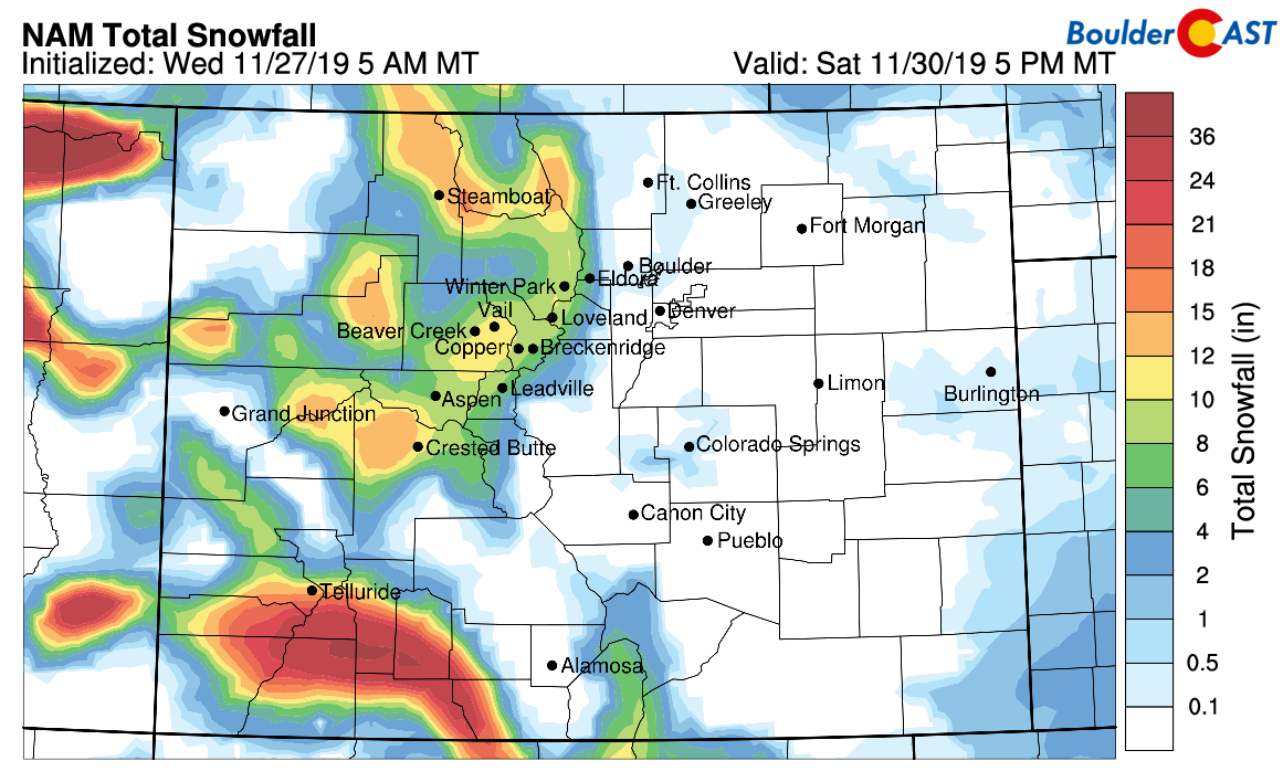
NAM model-derived snowfall forecast through Saturday
From all of us at BoulderCAST, have a Happy Thanksgiving!

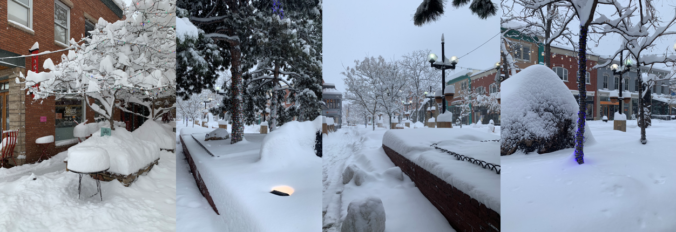
Featured images of downtown Boulder’s Pearl Street by Jenny Bloom.
We discuss Boulder and Denver weather every single day on BoulderCAST Premium. Sign up today to get access to our daily forecast discussions every morning, complete six-day skiing and hiking forecasts powered by machine learning, access to all our Front Range specific weather models, additional storm updates and much more!

.
Share Colorado weather, share this post:
.


You must be logged in to post a comment.