The week starts off mild and relatively quiet in the Front Range, but trends chilly and unsettled yet again by mid to late week. Mother Nature wants to keep a rather active pattern around for us to begin the month of May. There is also a possibility of some snow mixing in for the latter part of the week, but chances for this drop dramatically from a climatology perspective once May rolls around. Read on as we break down our weather for the week ahead.
This week’s highlights include:
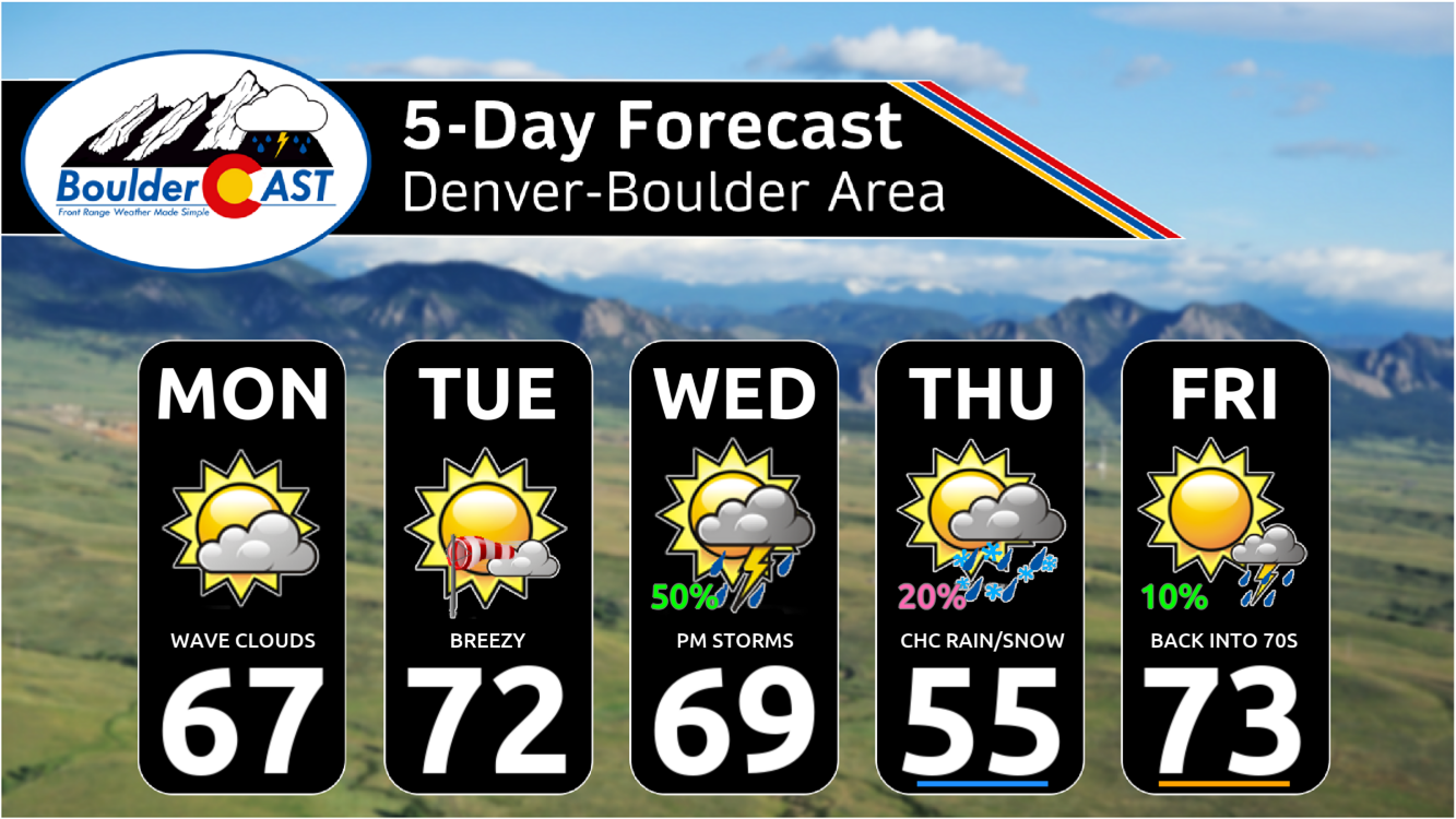
- Above normal temperatures in the upper 60s to lower 70s into midweek
- Chilly and below normal temperatures Thursday behind a strong cold front
- Largely dry to start, but precipitation chances return Wednesday
- The chance of a few snowflakes mixing in cannot be ruled out Thursday as temperatures tumble
- Gusty winds Tuesday and Wednesday
DISCLAIMER: This weekly outlook forecast is created Monday morning and covers the entire upcoming week. Accuracy will decrease as the week progresses as this post is NOT updated. To receive daily updated forecasts from our team, among many other perks, subscribe to BoulderCAST Premium.

Go Premium, get all the perks.
Daily Forecast Updates
Get our daily forecast discussion every morning delivered to your inbox.
All Our Model Data
Access to all our Colorado-centric high-resolution weather model graphics. Seriously — every one!
Ski & Hiking Forecasts
6-day forecasts for all the Colorado ski resorts, plus more than 120 hiking trails, including every 14er.
Smoke Forecasts
Wildfire smoke concentration predictions up to 72 hours into the future.
Exclusive Content
Weekend outlooks every Thursday, bonus storm updates, historical data and much more!
No Advertisements
Enjoy ad-free viewing on the entire site.
Warm & mostly dry through midday Wednesday
Our week is going to start off rather quiet into about midday Wednesday. The pattern will favor a west-southwest warm flow bringing in mild and above normal temperatures in the upper 60s to lower 70s. This will close out our April and start the month of May too. Below shows the pattern for midday Tuesday. High pressure to our southeast and low pressure to our northwest will usher in the warm westerly downslope flow. The trough to our northwest Tuesday will be our weather-maker for the latter part of the week, which we will discuss later.
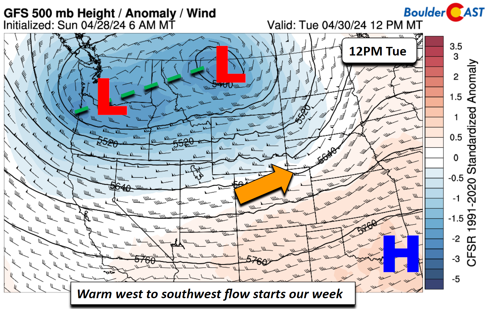
Speaking of that chance of unsettled weather for the tail-end of the week, the GEFS precipitation ensemble for Boulder is shown below. The main highlight in this graphic is the Wednesday to Friday period, which is our main precipitation chance. You’ll notice also some “blue” colors mixed in there too — that is of course a chance for snow. There is also a chance of some isolated showers or a storm Tuesday afternoon or evening with a strong front/trough passing through to our north. The main influence from this trough will be gusty winds up to 30 mph from the west and southwest for the Front Range, but some weak instability could touch off a low-end rain chance Tuesday along the Wyoming Border. This trough will also bring upslope snow/rain to the northern mountains of the state Tuesday.

Wednesday will remain mild in the 60s and 70s but unsettled weather looks likely late in the day, which we will discuss next.
Turning unsettled late Wednesday through the remainder of the week
By late Wednesday and into Thursday, the trough to our northwest earlier in the week is forecast to dig south and east, with the axis stretching perhaps from Montana into western Colorado by 6:00 AM Thursday. A northern lobe will stay to our north, while the southern lobe will pass across Colorado late Wednesday through Thursday.
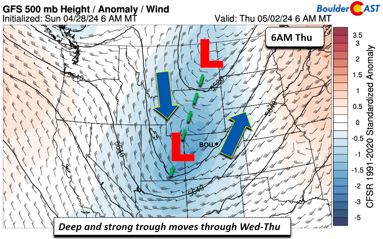
As it stands now, a surface low will track right across the Front Range late Wednesday before reaching the upper Mississippi Valley Thursday morning. This will bring a strong cold front through Wednesday night, with northerly winds gusting up to 30-40 MPH upon its passage. But more importantly, near-freezing above surface temperatures will ooze into the area Thursday morning, which could make precipitation types a little fuzzy for early May.
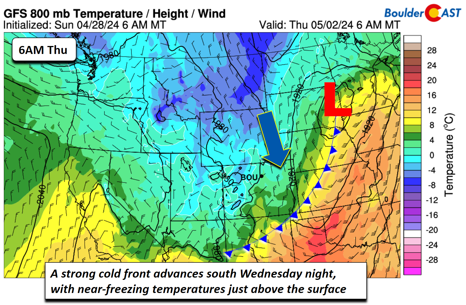
Either way, it’s going to be much colder Thursday and Friday with highs ranging from the 50s to some low 60s, but highs may struggle to get out of the 40s on Thursday (or 30s if the trend is colder). The main chance of precipitation appears centered on late Wednesday night (with the cold front and upper-level energy) into late Thursday night or early Friday (with the lingering upslope and passing mid-level energy). As it stands now, the thickness levels drop the lowest Thursday morning and afternoon, where snow could mix in with the upslope pattern.

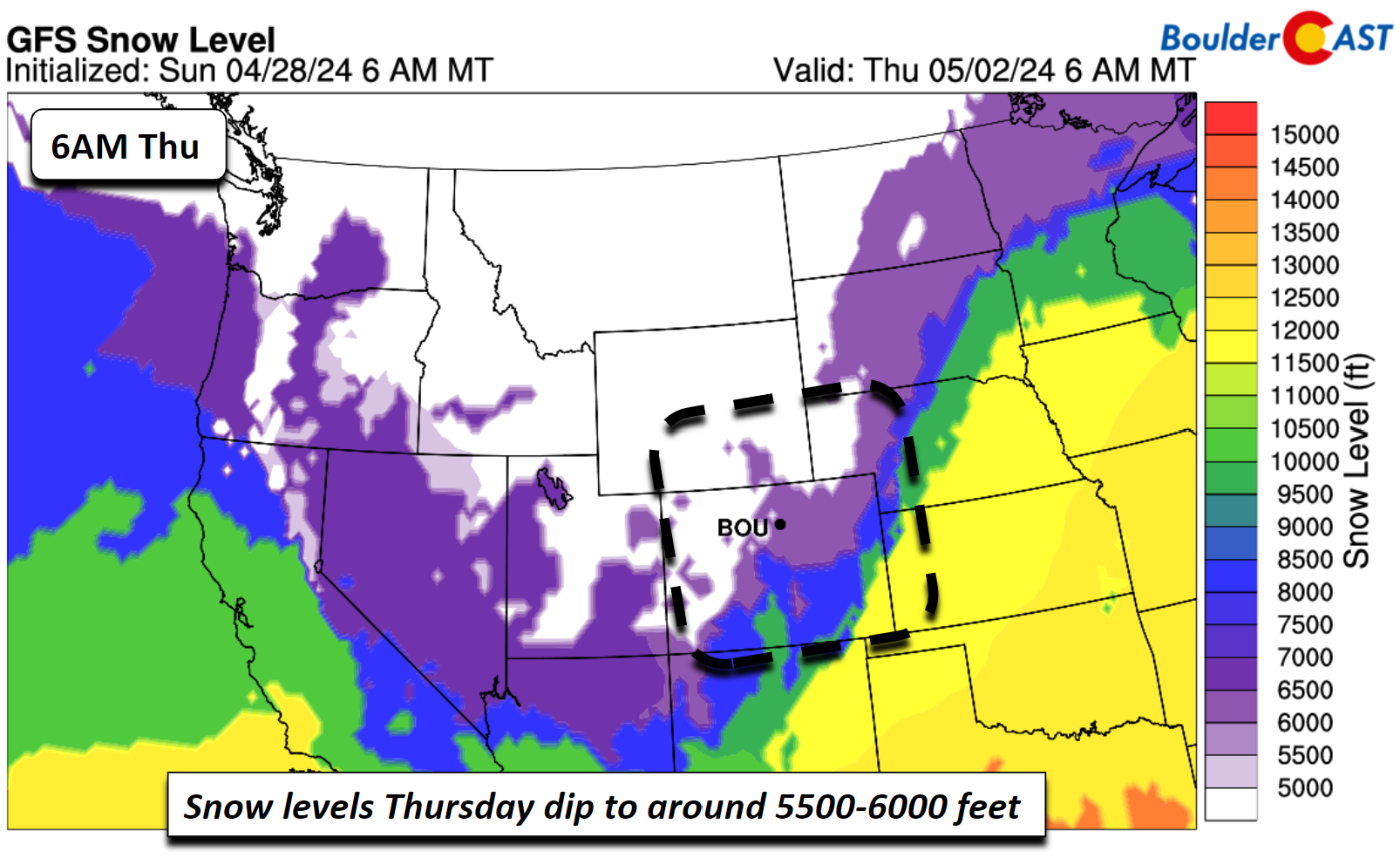
Snow levels forecast from the GFS suggest that the snowflakes could fall to levels of 5500 to 6000 feet, very close to the Denver/Boulder elevations. This is similar to the storm we had this past weekend, perhaps even a tad colder.
A look at our snowfall probabilities suggests a ~35% chance of 1 inch or more of snow with the late-week event. 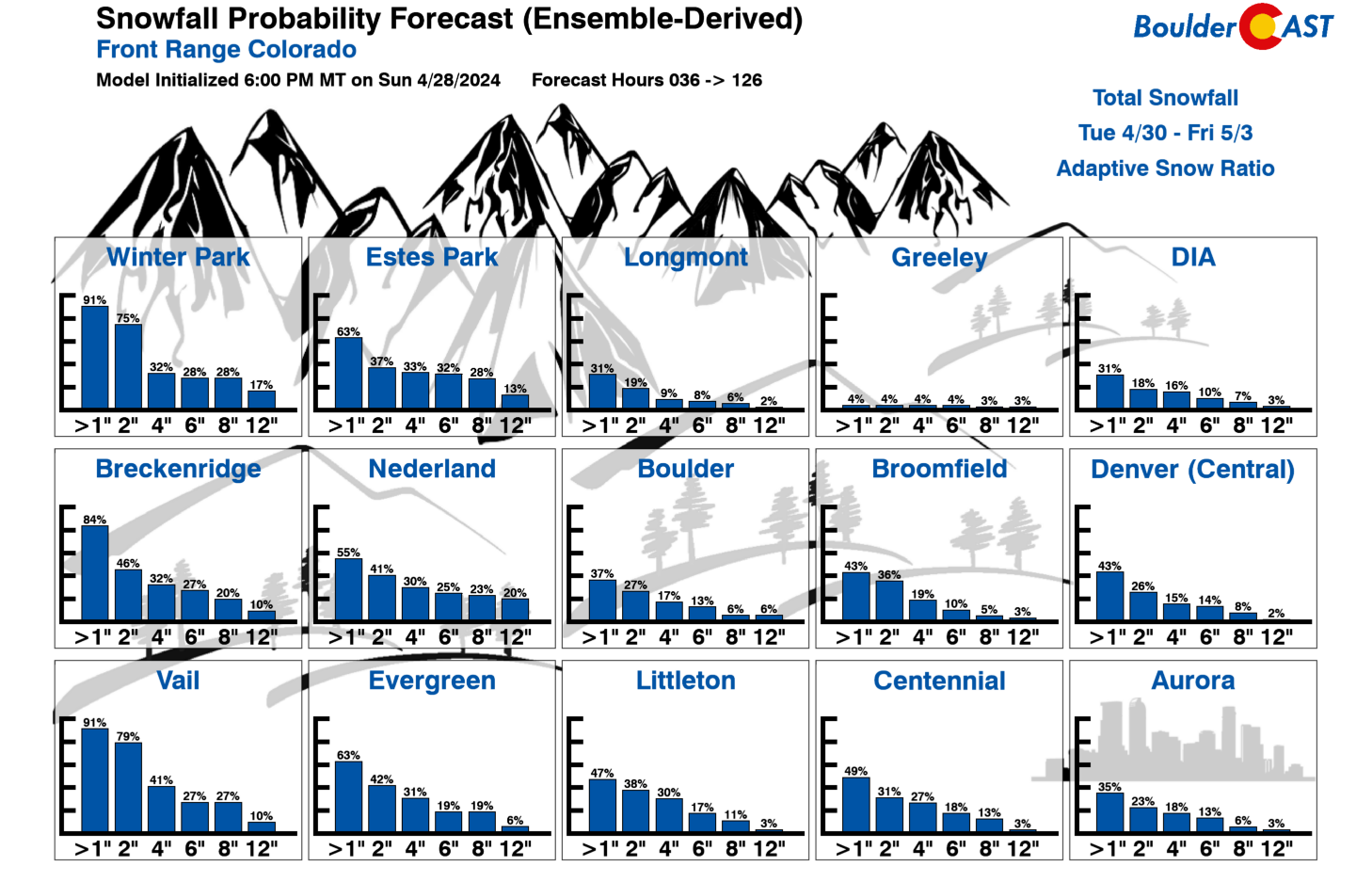
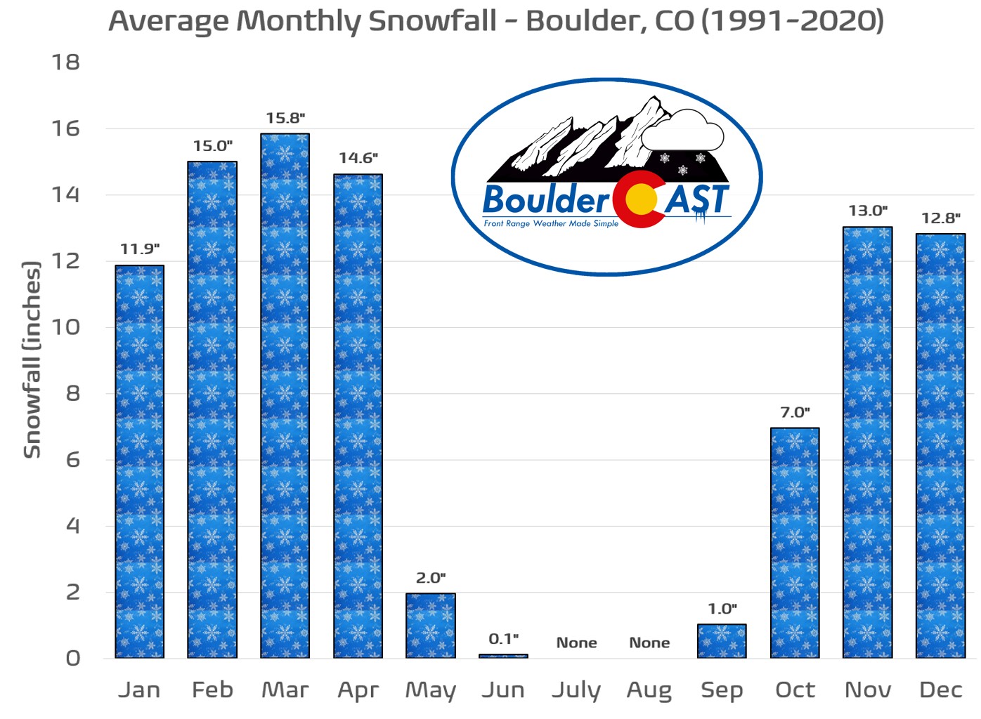
Note that these probabilities are largely driven by the GEFS, but some members of the ECMWF/CMC ensembles are further north with the secondary southern wave on Thursday which would not favor as much precipitation or cold air. So there definitely is uncertainty in the forecast, compounded also by the fact that early May snow chances are difficult to come by climatologically (see below). Nevertheless, Mother nature does not want to let go of winter, as usual in the Front Range, and this slight potential for snowflakes will be something to watch.
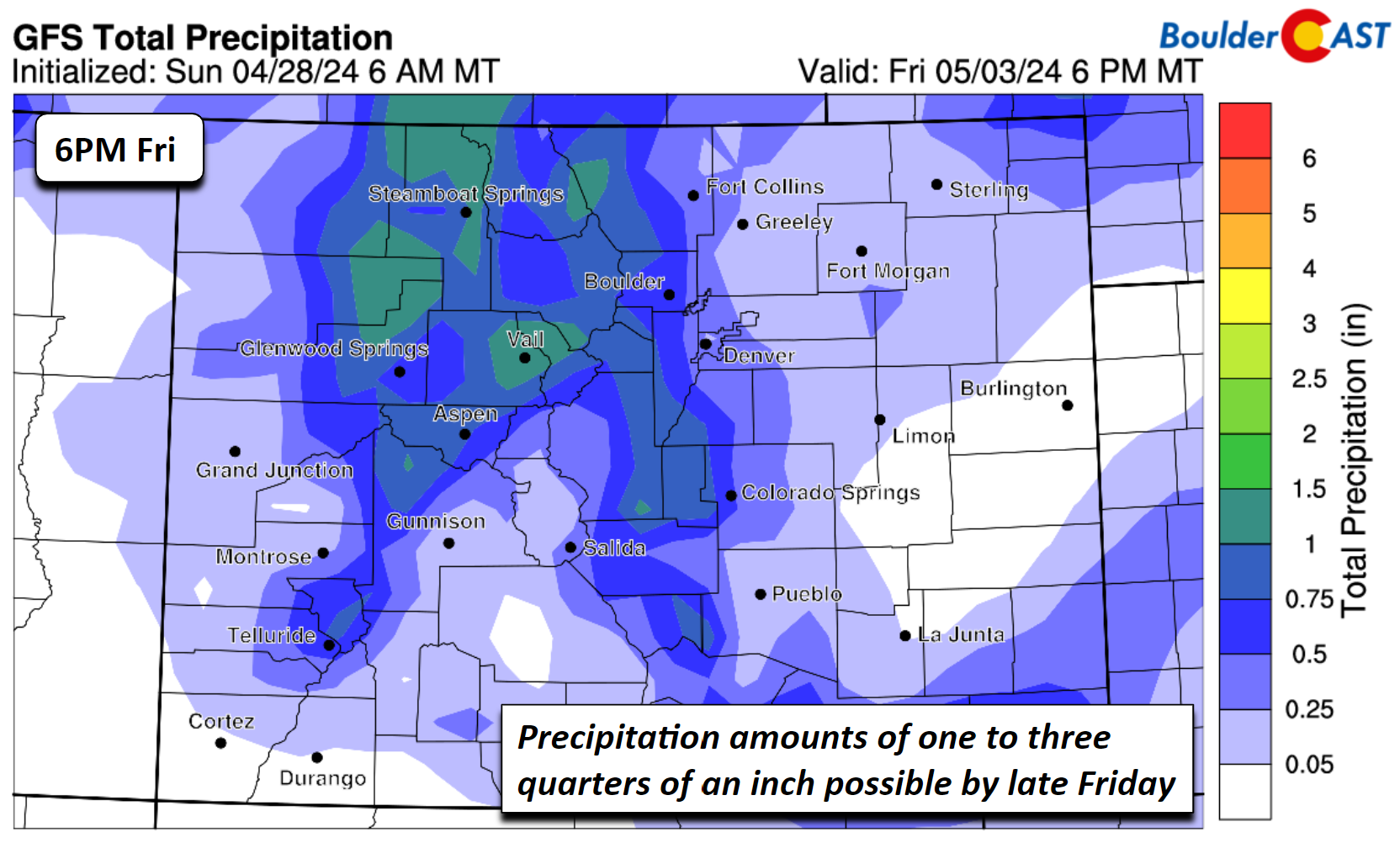
Regardless if any wet snowflakes mix in Thursday or early Friday, a good swath of precipitation is expected. Amounts of 0.25″ to 0.75″ could fall by late Friday (more in the Mountains), enough to keep the grasses greening, the trees budding, and the flowers blooming!
The unsettled weather could continue Friday as another shortwave tracks eastward to our north. This one would favor rain/snow chances in the Mountains, but mostly downslope/warm weather in the Metro area.

Enjoy the warm weather while you can before it cools off and turns somewhat wetter later this week.
STORM TOTALS ARE IN!
⛰️ Boulder: 2.16" precip, 0.6" of snow, Apr 27 new precip record (1.93")
🏙️ Denver: 1.74" precip, trace of snow#COwx #Denver #Boulder #Boulderwx pic.twitter.com/9ggS9yn5Wu— BoulderCAST Weather 🏔️❄️ (@BoulderCAST) April 28, 2024
Get BoulderCAST updates delivered to your inbox:
Forecast Specifics:
Monday: Mostly sunny and mild with upper 60s for the Plains and upper 50s in the Foothills. Afternoon breezes up to 20 MPH from the west.
Tuesday: Partly to mostly sunny, breezy, and mild with lower 70s for the Plains and lower 60s in the Foothills. There is a low-end chance of a few isolated storms in the afternoon and evening, mainly along the Wyoming Border.
Wednesday: Increasing clouds with highs mild to start in the low 70s on the Plains and near 60 in the Foothills. Turning gusty and colder Wednesday evening/night with thunderstorms and rain likely, with snow mixing in for the Foothills.
Thursday: A chance of rain showers continuing, with snow possibly mixing in across parts of the area. Highs in the 50s across the Plains with lower 40s in the Foothills.
Friday: Becoming partly sunny and warmer with highs in the 70s for the Plains and low 60s in the Foothills. Likely it will be mostly dry.
DISCLAIMER: This weekly outlook forecast is created Monday morning and covers the entire upcoming week. Accuracy will decrease as the week progresses as this post is NOT updated. To receive daily updated forecasts from our team, among many other perks, subscribe to BoulderCAST Premium.
Go Premium, get all the perks.
Daily Forecast Updates
Get our daily forecast discussion every morning delivered to your inbox.
All Our Model Data
Access to all our Colorado-centric high-resolution weather model graphics. Seriously — every one!
Ski & Hiking Forecasts
6-day forecasts for all the Colorado ski resorts, plus more than 120 hiking trails, including every 14er.
Smoke Forecasts
Wildfire smoke concentration predictions up to 72 hours into the future.
Exclusive Content
Weekend outlooks every Thursday, bonus storm updates, historical data and much more!
No Advertisements
Enjoy ad-free viewing on the entire site.
Enjoy our content? Give it a share!


You must be logged in to post a comment.