There is so much to unpack with this storm, from the moment it caught our eye a week in advance until the last snowflakes were flying, it was one-of-a-kind snowstorm and a true Front Range weather experience. We discuss the forecasting challenges leading up to the event, why many folks lost patience with this storm, and the massive snow totals the system eventually dumped across the Denver Metro area.
Help support our team of Front Range weather bloggers by joining BoulderCAST Premium. We talk Boulder and Denver weather every single day. Sign up now to get access to our daily forecast discussions each morning, complete six-day skiing and hiking forecasts powered by machine learning, first-class access to all our Colorado-centric high-resolution weather graphics, bonus storm updates and much more! Or not, we just appreciate your readership!

We’ll preface with a warning that this is going to be a LONG post. If you’re just just looking for to-the-point regional snowfall totals from this big storm, jump ahead to the final section.
Without further adieu, let’s jump in!
The lead up to the storm
This snowstorm was a huge win for modern weather forecasting as a whole. At the forefront of the victory were the weather models which amazingly predicted the storm somewhat accurately more than a week in advance. Undoubtedly, a huge factor of the win was also the local weather community, which banded together to raise awareness of the storm and kept the public up-to-date with the latest information available.
Because this storm was so predictable, the public was able to catch a rare glimpse into the entire weather forecasting process, from nearly start to finish, if they chose to follow along. What seemed like fantastical blizzard in the extended forecast evolved into a reality slowly and surely as last week progressed. With such potentially huge implications and the continued rise of modern social media, the public likely learned a lot this week about weather forecasting, perhaps more than they ever wanted to. Let’s take a look back at how the forecast evolved last week and what was going through our minds each day.
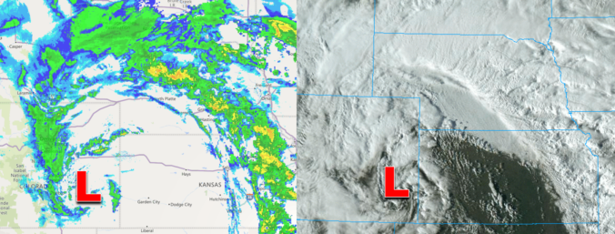
Sunday March 7th: Our team became more aware of a persistent feature in the models and first alerted our readers to the potential southern-track winter storm in this day’s Premium weather discussion.
Monday March 8th: Like every Monday morning for the last six years, we published our normal weekly weather outlook. While a majority of our discussion focused on the tamer pre-storm period, we dedicated a few paragraphs at the end to alert you to the storm and discuss some of the possibilities. This was just a heads up for you to pay special attention to the late-week weather as it had the early signs of being a major winter storm for our area. By Monday night, there was a lot of buzz in Denver already about the storm, facilitated by several headlines focusing on a small subset of weather models which at the time were predicting upwards of 6 feet of snow in Denver.
Tuesday March 9th: Huge Front Range snowstorms are routinely predicted in the 7 to 14-day timeframe by most global weather models. Few ultimately come to fruition, however. This storm was clearly different though. Seven days out, we were already seeing excellent inter-model ensemble support for the track, scale and intensity of the storm. By Tuesday, we were certain that this would be a major snowstorm and we weren’t shy about letting you know. However, it wasn’t clear if this meant a crippling historic snowstorm or just a big snowstorm. That was still TBD.
We felt comfortable enough with the forecast data we were seeing to throw out some initial snowfall predictions. At the time, these amounts were fairly conservative given the model data at hand. However, for public awareness, it’s always better to be conservative early in the game and trend amounts upward if needed. The opposite approach usually doesn’t go over too well.
Wednesday March 10th: By Wednesday, several weather models started to show some signs that the storm system would take a track slightly further north. Minor forecast track shifts are normal as time goes on, so this wasn’t a major concern for us. In fact, this shift was something accounted for in our forecast all along. With the storm’s massive scale, even though the best bullseye of heaviest snow was shifting towards Wyoming, there would still be plenty to go around across northern Colorado as well. Of course we didn’t know it at the time, but that northward track would eventually prove to verify. Our overall forecast message remained unchanged. We started to dial in the timeline of the storm as well, indicating that the worst of the snowfall would occur Saturday into early Sunday.
Even with the northward shift, models continued to indicate big snow totals across the Front Range and we bumped up our initial snowfall predictions by a small amount.
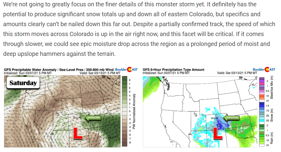
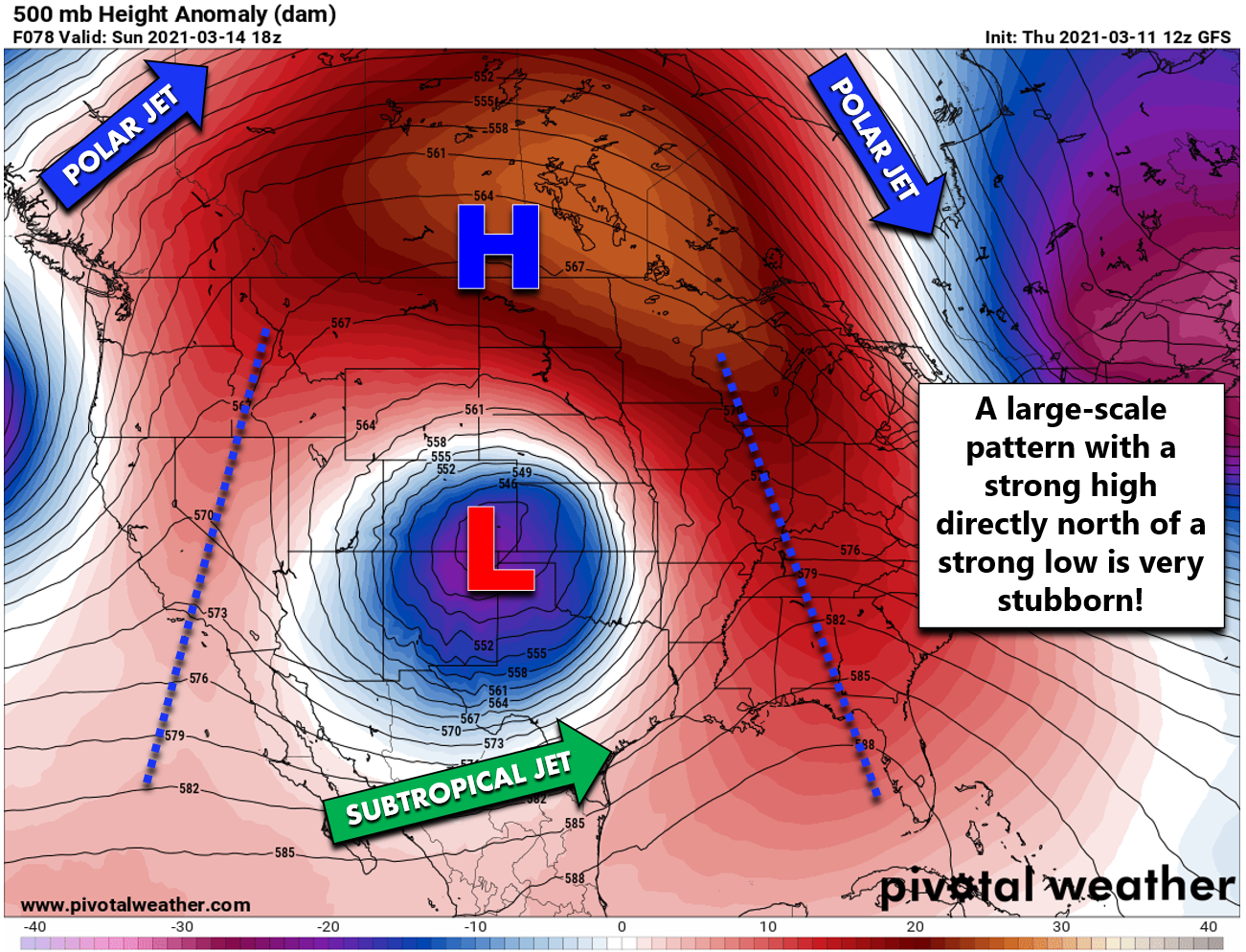
Thursday March 11th: The major update to the forecast on Thursday was the timing. The storm was slowing down. Not only did this delay the storm’s arrival, it also meant that once the storm showed up, it would be slow to exit paving the way for continued confidence in very large snowfall totals. The storm’s sluggish movement was related to a specific large-scale weather pattern shown below.
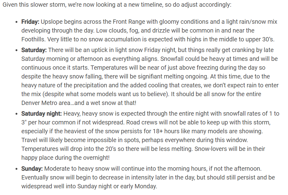
We were clear to outline the new timeline of the storm, with everything pushed back in time by about 12 hours.
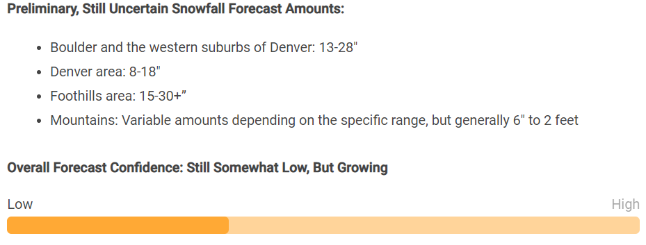
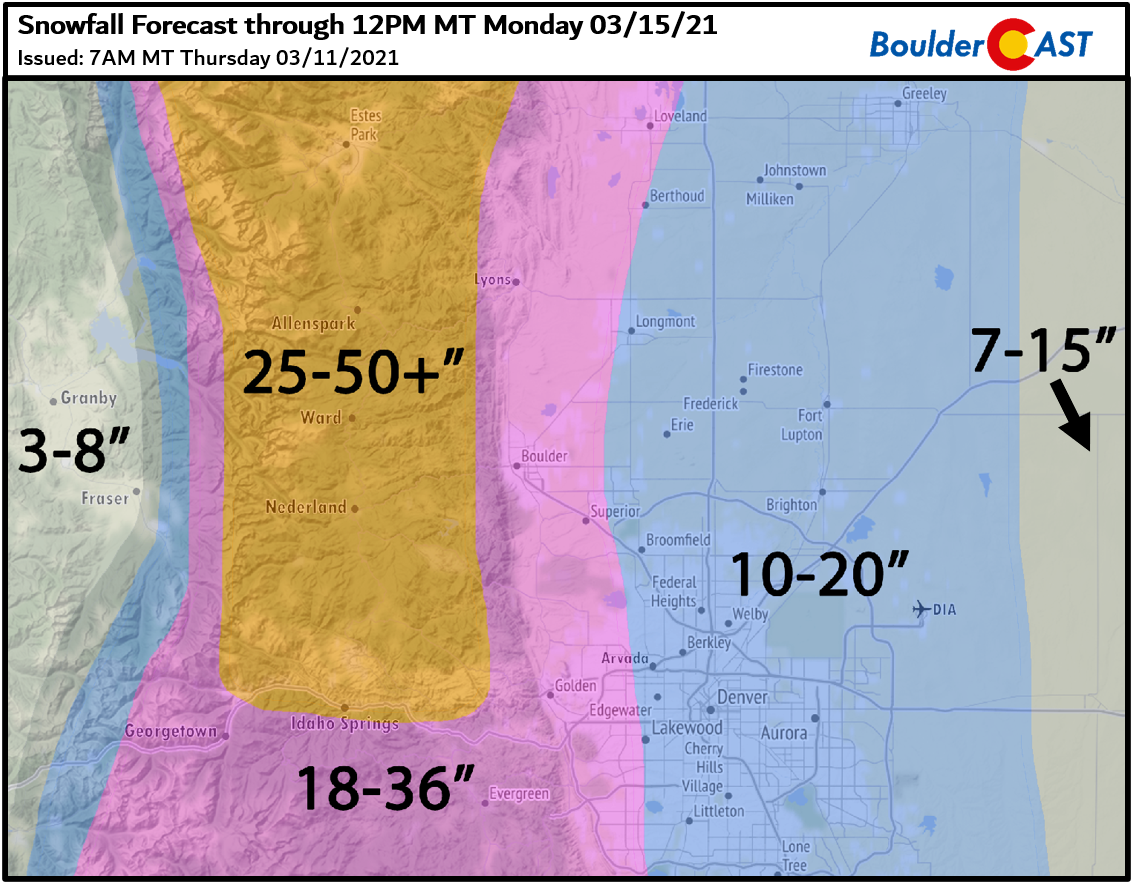
We also highlighted our growing forecast confidence and continued to bump up snowfall totals slightly in the western Metro area specifically, mainly due to expected prolonged period of intense upslope. Thursday was also the day when we issued our preliminary snowfall forecast map.
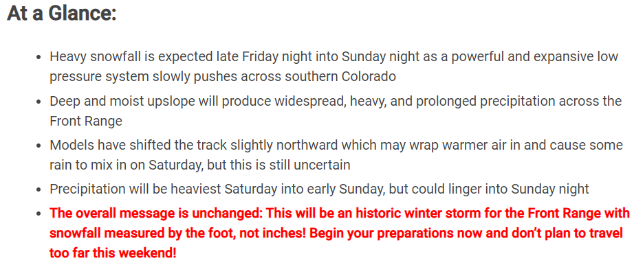
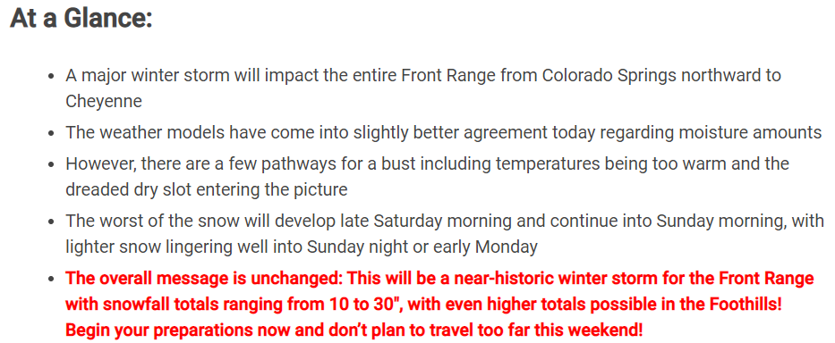
Friday March 12th: Our forecast update on Friday covered two of our lingering concerns.
- WARM AIR: Warm air intrusion from the east which could cause rain to mix in with the snow on Saturday. Even though some models were very persistent about this aspect, we were not too worried and expected almost entirely snow from this system.
- THE DRY SLOT: Models were all over the place with the dry slot. Some bringing it further north and west. We weren’t overly concerned about this either since it was such a long duration event, but it certainly could impact totals if the dry slot did linger in one location too long.
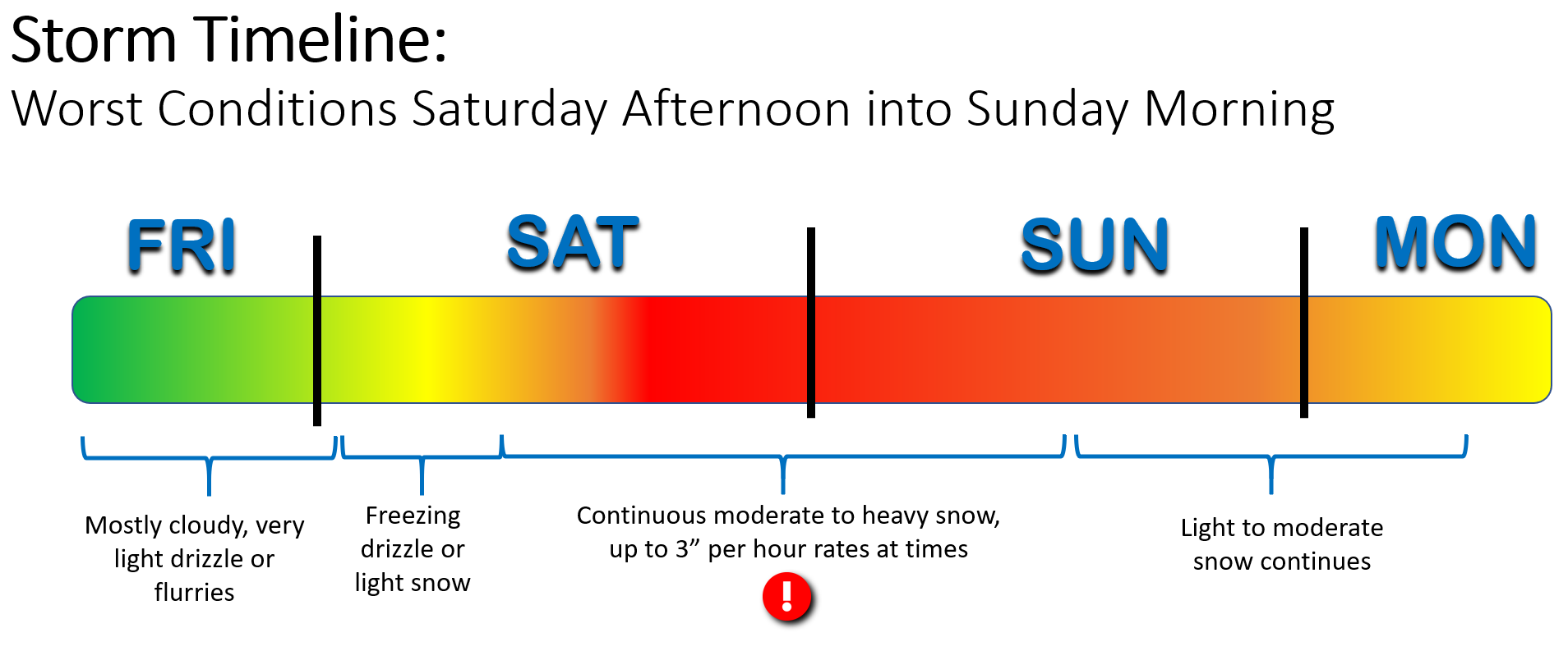
We provided the graphic below of the latest storm timeline, with the worst impacts from heavy snow expected Saturday afternoon into Sunday afternoon.
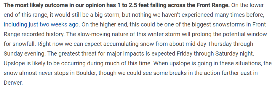
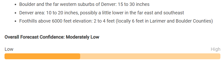
Model consensus was coming in with better agreement for the storm at this point, which helped boost overall forecast confidence. However, the agreement was now for slightly reduced snowfall totals. Nothing major, but we decided to knock a few inches off our forecast in some locations. Still this was to be a highly impactful storm for the entire area.
As with every snow forecast we draw up, we tried to set the proper expectations on snow amounts for this ultra-hyped storm. We always give ranges for expected amounts, but for big storms such as this, many people focus too heavily on the top of the range and forget entirely about the bottom.
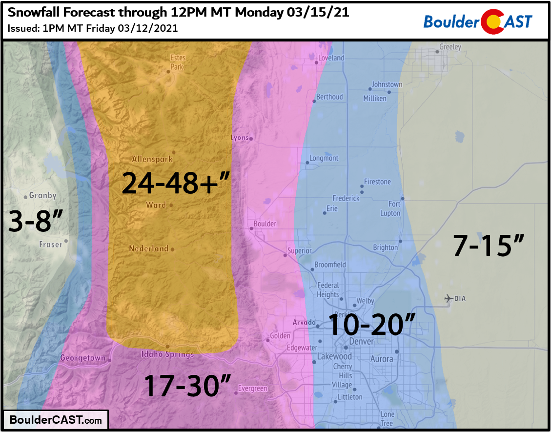
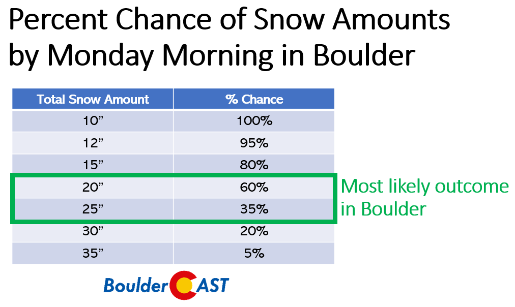
For this storm in Boulder specifically, our final forecast for this event called for 17 to 30 inches of snow (see map above). Quite a big range, we admit, but it honestly was the spread we felt comfortable forecasting given the situation. We believed that spread would capture a majority of the possible outcomes. Sometimes there are just too many moving parts to nail down amounts any better beforehand. In this case, we had concerns about the timing of the storm being during the day, the warm air intrusion causing some rain early on, possible dry slotting, worries that the track was just a hair too far north, and the uncertainty surrounding the snow ratios. Because of these unknowns, we also included a probability forecast, showing the odds of exceeding specific snowfall amounts (below). The sweet spot for Boulder was somewhere between 20 and 25 inches in our opinion. As you can see, though, we still believed there was a 20% chance that Boulder could see less than 15″ and also a 20% chance Boulder could exceed 30″. Those two outcomes combined comprised 40% of the outcomes, leaving a bigger but not all-encompassing 60% probability that our forecast would verify. It we wanted to make sure our forecast would be right 90% of the time, we would have had to expand our expected forecast range to be 12 to 36 inches in Boulder. That’s clearly not very helpful. Ultimately when we decide on a snowfall range forecast for a given location, it’s a balancing act between capturing as much of the potential outcomes as possible, but doing so without compromising the integrity of the forecast itself with a range far too large.
As the storm unfolded….
By Saturday morning, the hype surrounding the storm about to unleash on the Front Range was raging out of control! Many folks woke up expecting it to be a winter wonderland outside, despite that not being a part of anyone’s recent forecasts, let alone ours. We’ll be the first to admit that the storm developed more slowly than expected. There was a period of drizzle and light rain Saturday morning, but most areas were fully changed over to snow by early afternoon.
11:30AM Radar Update: Light rain will transition to heavy snow in across the area soon. Temps are still above freezing, and combined with the mid-day March sun, there will be a lot of melting early on
More current conditions: https://t.co/bg05MB0SxZ#COwx #Snowmageddon2021 pic.twitter.com/nfgbXvL4wz
— BoulderCAST Weather (@BoulderCAST) March 13, 2021
In order to hedge off growing suspicions that the forecast could be a bust, we put out a brief storm update Saturday morning. In this post, we thought we were making the current status of the storm crystal clear!


Boy, were we wrong about that last part! The “melty” look to the snow Saturday afternoon and evening caused a good chunk of the internet to congeal into a hate group targeting any and all weather forecasters. Our team weren’t the only victims. Just about every valuable source of weather information in the Denver area was hit hard by misguided negativity and public outrage. It’s not something we personally get worked up about. It’s happened before and it will surely happen again. It comes with the territory of weather forecasting. No matter how much time we spend sifting through the data and how confident we are in the going forecast, sometimes we’re just not right (remember those probabilities?). That’s the nature of the business. We have excellent forecast tools these days compared even to just 20 years ago, but we’re still predicting the future and that doesn’t always pan out. A busted forecast hits us harder than it hits you. Trust us on that one.
By Saturday night, despite a full day of wet snow falling, there wasn’t that much to show for it with only around 5″ on the grassy surfaces in Boulder and Denver. Again, late Saturday evening, we attempt to quell the fears of a monumental bust by reminding everyone that though just 5″ of snow had fallen, we were only 10 hours into a 40-hour snow event…
9PM Saturday Update: We're *only* 10 hours into a 40-hour snow event and we've seen about 5" in Boulder so far. Snow will continue well into Sunday night. Still a long window for heavy wet snow ahead! #COwx #Boulder pic.twitter.com/7ydUhtDkiV
— BoulderCAST Weather (@BoulderCAST) March 14, 2021
You already know where this story ends up…but let’s go through it anyways….
Just after we made that above post, the storm finally got into position and started to get its act together. Heavy snow began to overtake the northern Front Range from Loveland northward to Cheyenne, including pockets of heavy thundersnow near the Wyoming Border.
Anyone see any flashes last night? Check out this video of thundersnow south of Cheyenne courtesy of Michael Gerringer. pic.twitter.com/bMjiezfmjX
— NWS Cheyenne (@NWSCheyenne) March 14, 2021
While a foot of snow fell up north through the night, the immediate Boulder and Denver area was fairly quiet during this time. As it turns out, a very long and narrow dry slot managed to weasel its way into the Denver Metro area greatly reducing the snowfall intensity overnight. This was always a possibility, though the chance was low.
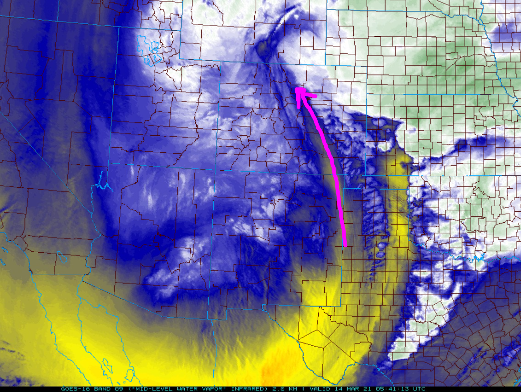
GOES-East water vapor satellite animation from Saturday night at 11PM
However, by morning the dry slot had exited and our main storm system had moved directly south of the Front Range along the New Mexico border. This position put our area in a prime location for due easterly upslope flow in the atmosphere. That trusty “Upslope Snow Machine” was turned up to max settings almost all of Sunday with snowfall rates of 1 to 3″ per hour being reported across the region.
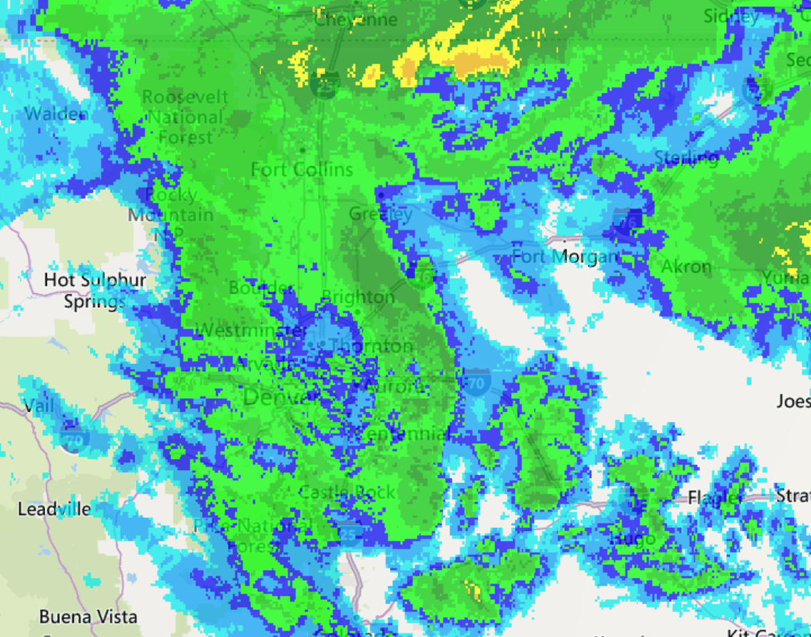
Radar animation from Sunday 3/14/21 in the morning. Heavy upslope flow continued.
The huge east-west extent of the heavy snow was indicative of a barrier jet along the western Metro area. When strong upslope flow slams in the terrain for an extended period, it eventually can turn southward and intensify causing a jet of cold air in the very lower atmosphere parallel to the Foothills. This cold dome of air acts as an obstruction itself causing added lift which stretches well away from the terrain.
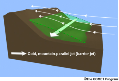
Possibly the only diagram showing a barrier jet online. Sorry it is so poor.
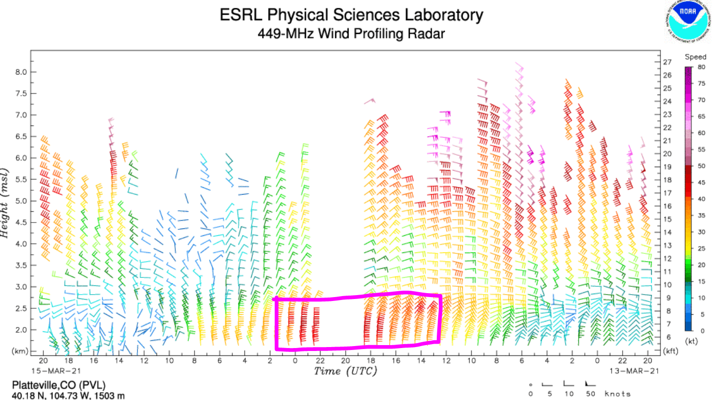
Observations from the Platteville wind profiling radar clearly showed the barrier jet developing Sunday morning and lasting into Sunday evening, which we have annotated below. Note how the strongest winds are located right near ground level and they are northerly. This is the signal of the barrier jet. Interesting, after nearly a foot of snow had fallen in southern Weld County Sunday, the radar site lost power. That’s why there is a large gap in the data below!
As heavy upslope snow fell across the entire area spurred on by the barrier jet, we put out our last storm update early Sunday morning with continued warning that the worst was still to come.
The heavy upslope snow continued through all of Sunday as the strong low pressure system sat nearly stationary across southeastern Colorado for a very long time. The water vapor satellite animation below spans from around 6:00 AM Sunday to 7:00 PM in the evening, a full 13 hours. Amazingly during this time, the cut-off low made a small loop-de-loop, but ultimately ended up only about 75 miles from where it started. You can see during this entire animation, very strong east and northeasterly flow is just ripping into the Front Range. This was an absolute perfect scenario for a prolonged period of heavy snow in the Denver Metro area!
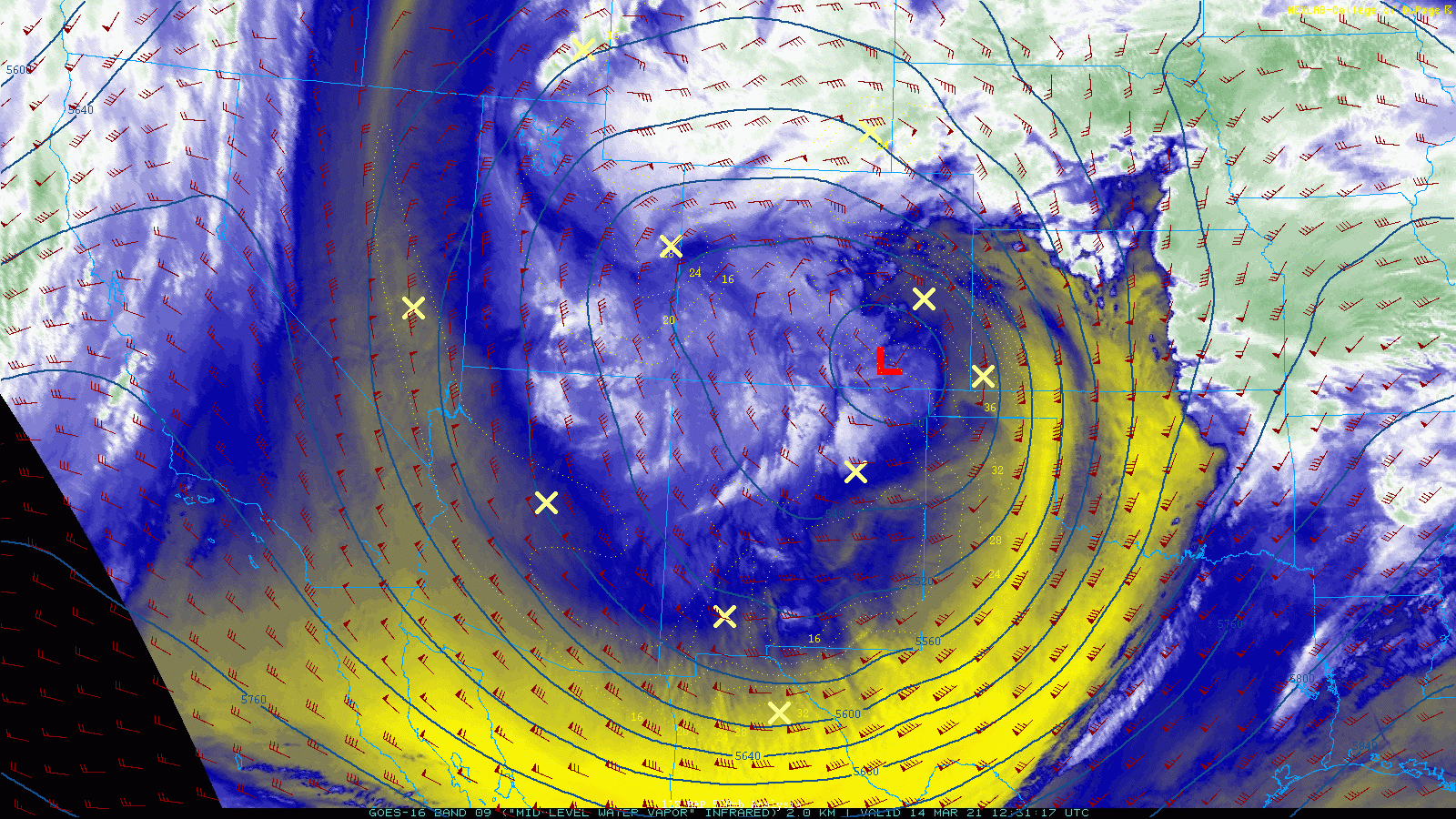
Infrared satellite animation from Sunday morning into Sunday evening. Overlaid height contours and winds are from the 500mb level.
Here’s a larger radar view of the entire low pressure system. Incredible! There’s nothing more beautiful than a massive mid-latitude cyclone sucking Gulf of Mexico moisture northward and then slamming into the terrain just west of Boulder and Denver!
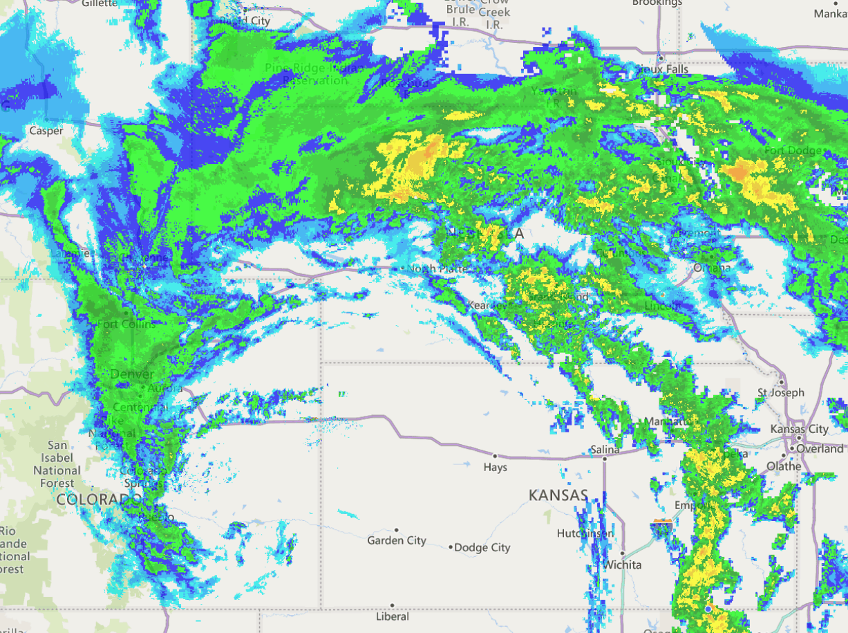
Regional radar animation from Sunday March 15 in the afternoon
OK we lied. There is something more beautiful….the visible satellite imagery of the very same low pressure at the very same time from GOES-East. What. A. Storm! Look closely and you’ll see smoke and a large dust storm getting pulled into the dry slot from west Texas.
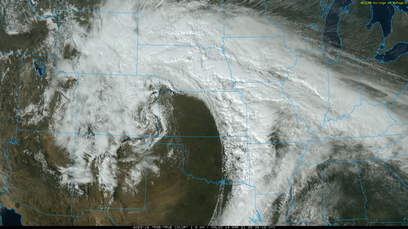
Regional visible satellite animation from Sunday March 15 in the afternoon
Sunday afternoon offered some of the most intense snowfall. This video is from Boulder where snow was falling at a rate of near 2″ per hour…
Live from #Boulder at 2:30PM. This is what 2 to 3" per hour snowfall looks like. Look at those aggregates! Storm total of ~17" so far. Likely to see a slew of 20+" totals across the lower elevations by the time this storm wraps up Monday morning. #COwx #DaylightSavingsSnowstorm pic.twitter.com/QfWOIULcRg
— BoulderCAST Weather (@BoulderCAST) March 14, 2021
Our last view of the storm unfolding comes via a timelapse from west Arvada (thanks for sharing Brent DePaepe!). You definitely want to watch this video until the end!
.
As the storm finally began to meander eastward into Kansas late Sunday evening, the snow relaxed and eventually tapered off fully after midnight Sunday night. By Monday morning, then entire Denver Metro area was blanketed in more snow than it had been in years!
Checking the totals
To put it simply, this storm absolutely delivered the goods! Maybe not the absurdly high snow totals indicated by some of the models a few days in advance, but look at that. What an impressive dumping of snow, not just in the Front Range, but over a huge area of Wyoming and Nebraska as well. It’s clear that Wyoming did end up stealing the “bullseye” from us, but (moisture) beggars can’t be choosers! With 2 to 3 inches of liquid widespread from this storm, northeast Colorado is likely to see some slight improvement in the ongoing drought.
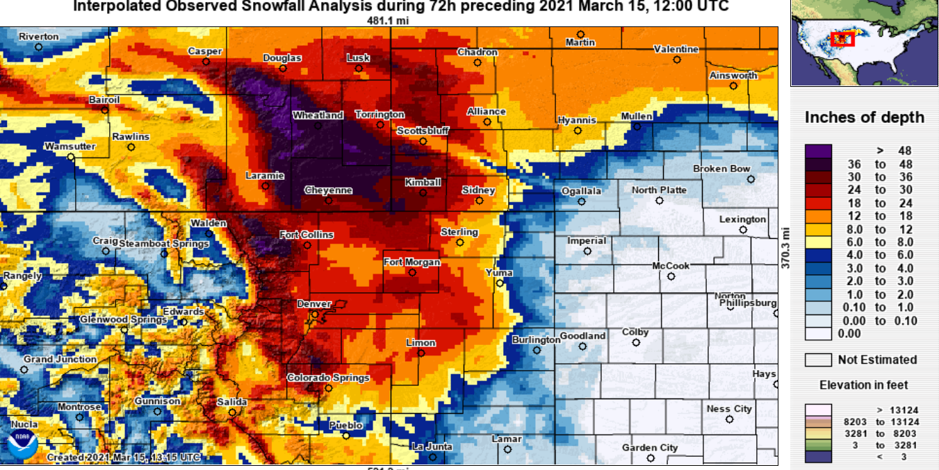
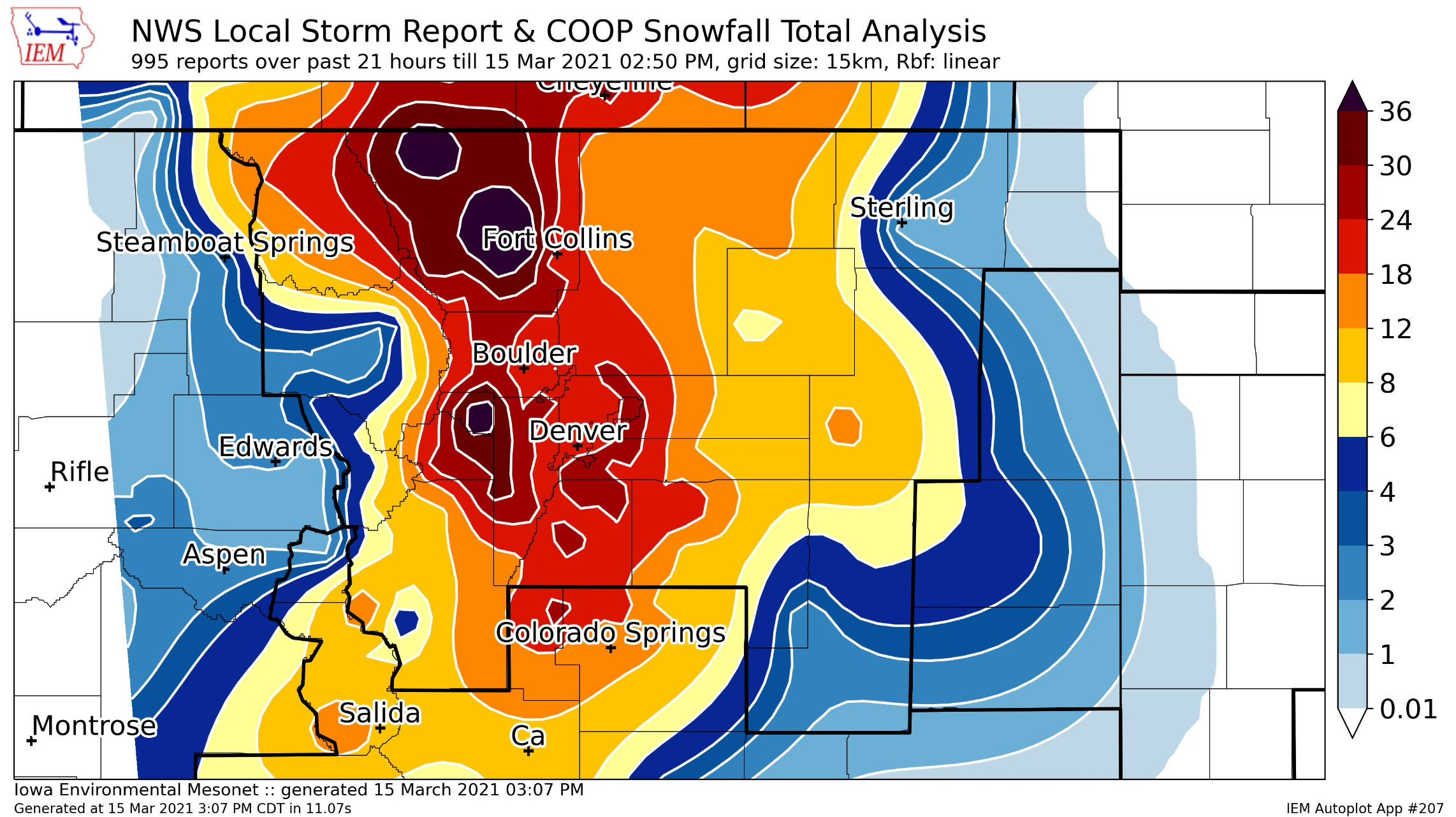
A closer inspection below shows three-day storm totals of 18″ or more across the entire Denver Metro area! In the Foothills, 2 to 3 feet were common. Larimer County was hit hardest, and that makes sense. Larimer County dodged the narrow dry slot Saturday night and cashed in on nearly as much intense upslope snowfall during the day Sunday.
Our snowfall forecast map for the event is shown below with storm totals overlaid. Green values indicate our forecast verified to within one inch. Red did not. Overall our forecast for this major winter storm verified quite well across the board. A few areas along the base of the Foothills came up short of our 17-30″ forecast range. This included the Gunbarrel area and Lyons. Elsewhere, pockets of booming snowfall occurred sporadically throughout the Denver Metro with totals pushing a few inches above our 10 to 20″ expected range.
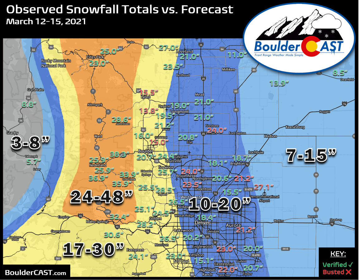
By far the worst busted forecast we had was at Denver’s official observation site, Denver International Airport. DIA recorded an insane 27.1″ of snow from this event (containing 2.88″ of liquid!), making this storm the 4th largest snowstorm in Denver’s historical record dating back to the 1870’s! Outside of west Arvada, this was also the largest reported total across the entire lower elevations. Heavy snow and blizzard conditions near DIA led to Peña Boulevard becoming impassable Sunday evening and the entire shutdown of all runways at the airport for around 24 hours.
At 1 a.m. DEN had received 27.1 inches of snow! Snow has stopped and crews are working hard to clear runways. At this time, all runways remain closed and all morning flights have been cancelled. If you're traveling today, please double check your flight status with your airline. pic.twitter.com/jMWn1nLZlo
— Denver Int'l Airport (@DENAirport) March 15, 2021
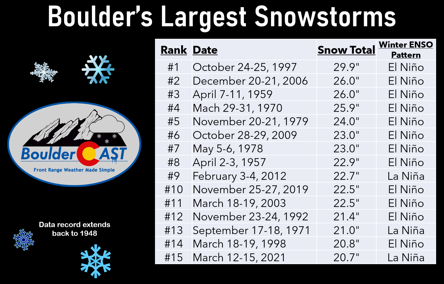
Boulder’s final total was a more modest 20.7″ from this storm which ranks 15th all time for the city dating back to 1948 when reliable snowfall data became available.
We also must give credit when credit is due. YOU really nailed the forecast! Well, at least a majority of voters in our pre-storm Twitter poll nailed it. We might have to consider more polls like this in the future since their consensus is currently 100% accurate.

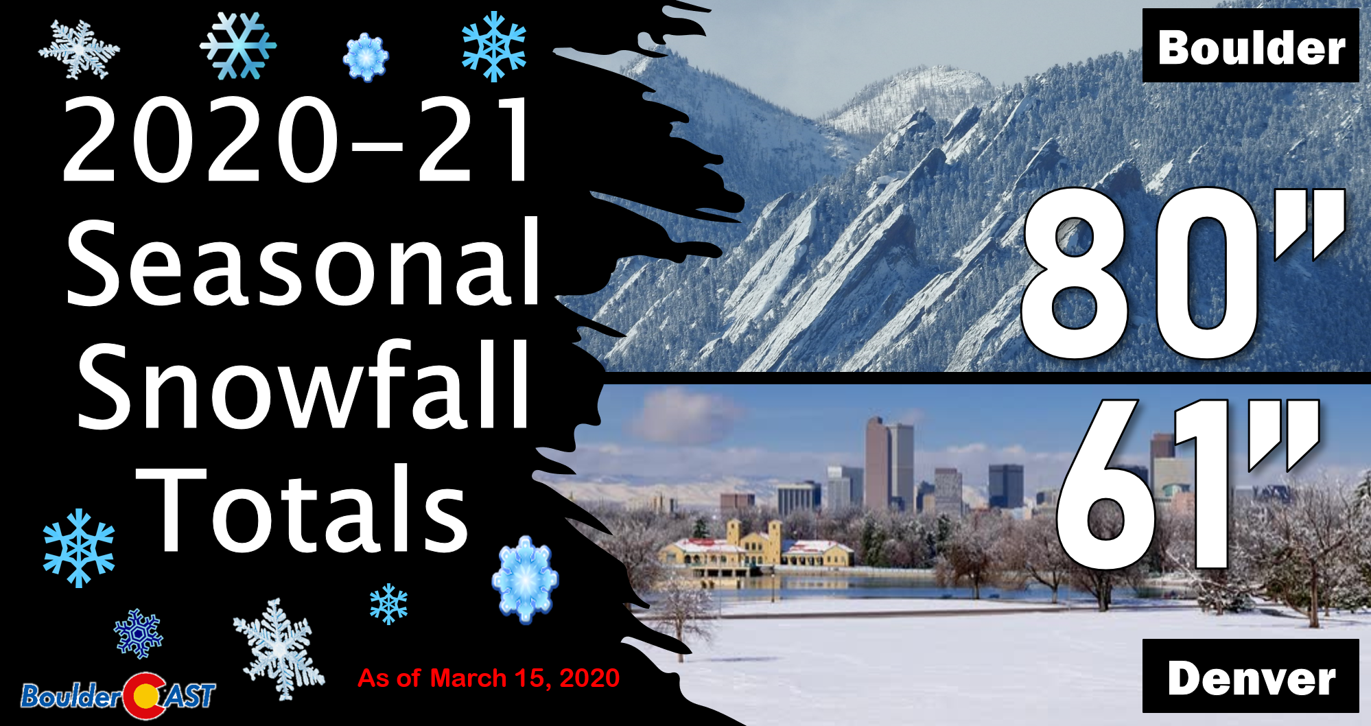
Denver now has 61″ of snow this winter, already surpassing the normal amount for the entire season (55″). Boulder has 80″ this winter and needs just a few more inches to complete an above average snow year (86″).
Finally, we wanted to touch on the snowfall ratios for this event, since they were a big unknown in the forecast going in. Based on observations from Boulder taken throughout the snowstorm, we can see that first and second halves of the storm had drastically different snow ratios. Early on Saturday and Saturday night, the snow was extremely wet and heavy with a ratio of 7 to 1. Yuck! However, during the day Sunday, the heavy upslope snow was much more dendritic and fluffy with a ratio of 15 to 1. If you did any shoveling over the weekend, you probably noticed the snow near the bottom was a lot heavier and more challenging to deal with than the fluff sitting on top!
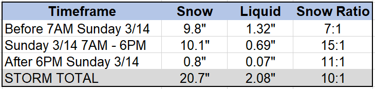
The storm average snow ratio ended up being just a bit under 10 to 1 in both Boulder (20.7″ snow, 2.08″ liquid) and Denver (27.1″ snow, 2.88″ liquid). If you recall, we predicted a 9 to 1 ratio for this particular storm (which is very low by Front Range standards). Not bad!
Final Thoughts
Was this storm historic? For Denver, certainly reporting 27 inches and the 4th largest snowstorm of all-time, it was! For Boulder, it was a big storm for sure, but not really historic. There’s a reason Boulder is often considered the snowiest “city” in America. 20-inch snowstorms happen in Boulder about once every 3 or 4 years on average. The last time was back in 2019. The time before that was in 2012.
The biggest challenge with this storm was the slow-down. It just kept getting slower and the timeline kept shifting. The public hype train had already left the station by Saturday morning, but the storm wasn’t ready to release its heavy snow yet! There’s actually a lot more to consider when a storm timeline shifts, not just the obvious. There’s many moving parts to a storm this large. The heaviest snow was slightly delayed but did eventually show up as forecast. This delay however made most of that heavy snow fall during the daytime Sunday which is warmer, has a higher sun angle, and thus more melting. So totals were not as impressive as they could have been had that heavy snow been dumping overnight. Furthermore, the daylight timing also allowed a signifiant amount of afternoon thunderstorms to bubble up in eastern Colorado and Kansas. Convective activity upstream in the moisture pipeline can “rob” the Front Range of that moisture before it even gets here to become our upslope snow. We generally don’t want to see a lot of thunderstorms out east during these type of events. The delayed timing alone likely cut several inches of snow off the storm’s potential, but we’ll never know for sure.
Overall, we’re happy with our forecast and how this incredible storm played out. We had consistent messaging for a solid six days leading up to the event. We couldn’t have done anything else differently here. We’re hopeful that this was a valuable learning experience for the community regarding weather forecasts, particularly for snowstorms. At the end of the day, as meteorologists we’ll get some forecasts right and we’ll get some forecasts wrong. Hopefully the former vastly outweighs the latter. Our team will continue to provide weather forecasts and discussion for Boulder, Denver and the surrounding areas tomorrow and beyond, for any and all that are interested in reading. Thanks for tagging along with us for this incredible journey this week. We hope you enjoyed it and learned something! It was a hell of a ride and an absolute joy to forecast. You never know…maybe next time Mother Nature will get the best of us. This time, though, we won!
.
Stay up to date with Colorado weather and get notified of our latest forecasts and storm updates:
We respect your privacy. You can unsubscribe at any time.
Help support our team of Front Range weather bloggers by joining BoulderCAST Premium. We talk Boulder and Denver weather every single day. Sign up now to get access to our daily forecast discussions each morning, complete six-day skiing and hiking forecasts powered by machine learning, first-class access to all our Colorado-centric high-resolution weather graphics, bonus storm updates and much more! Or not, we just appreciate your readership!
.


You must be logged in to post a comment.