
The winter storm we’ve been tracking all week long is finally bearing down on Front Range Colorado and forecast confidence is not as high as we’d like this late in the game. We discuss the latest developments, including multiple pathways for a bust east of Interstate 25, and provide our latest snowfall forecast map.
At a Glance:
- A major winter storm will impact the entire Front Range from Colorado Springs northward to Cheyenne
- The weather models have come into slightly better agreement today regarding moisture amounts
- However, there are a few pathways for a bust including temperatures being too warm and the dreaded dry slot entering the picture
- The worst of the snow will develop late Saturday morning and continue into Sunday morning, with lighter snow lingering well into Sunday night or early Monday
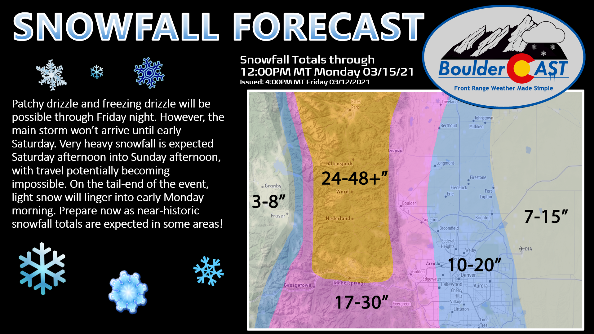
- The overall message is unchanged: This will be a near-historic winter storm for the Front Range with snowfall totals ranging from 10 to 30″, with even higher totals possible in the Foothills! Begin your preparations now and don’t plan to travel too far this weekend!
Help support our team of Front Range weather bloggers by joining BoulderCAST Premium. We talk Boulder and Denver weather every single day. Sign up now to get access to our daily forecast discussions each morning, complete six-day skiing and hiking forecasts powered by machine learning, first-class access to all our Colorado-centric high-resolution weather graphics, bonus storm updates and much more! Or not, we just appreciate your readership!

Winter is definitely coming!
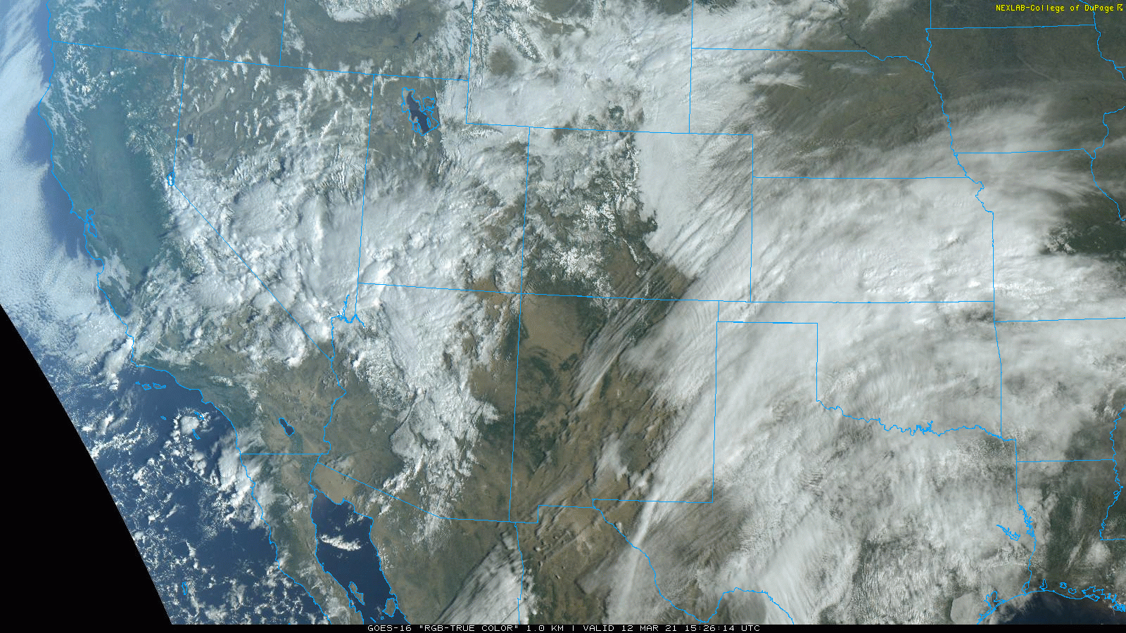
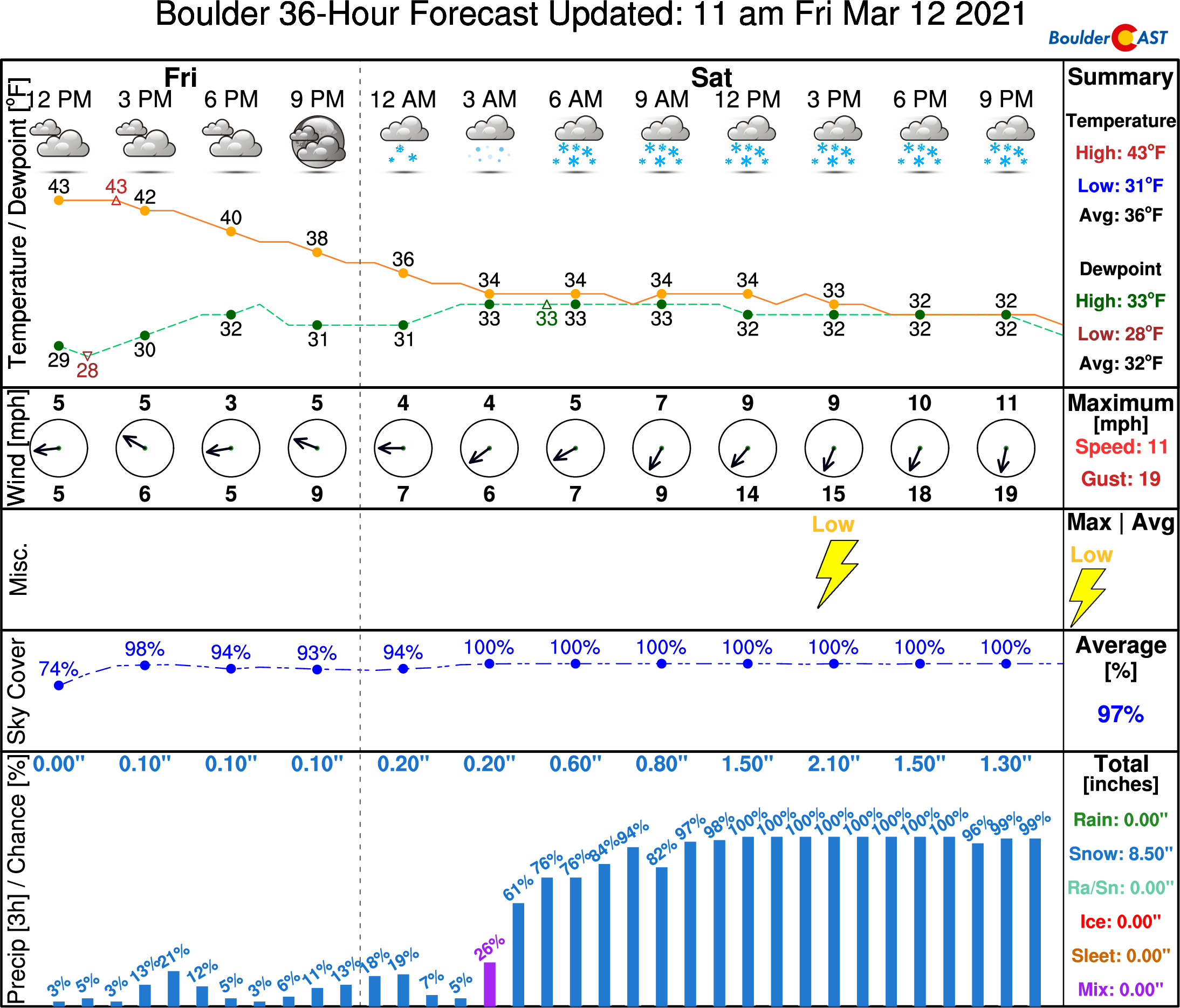
We’re now less than 24 hours from the first wave of widespread snowfall overtaking the Front Range. We’re currently in the preparation phase, awaiting the main event that will take center stage this weekend. The center of the powerful cut-off low pressure is located near Las Vegas this afternoon. It will continue to move eastward slowly into southeast Colorado by the end of the weekend. Moist southeasterly upslope way out ahead of the system is already creating low clouds across most of eastern Colorado. This will continue through Friday night with patches of drizzle, especially near the Foothills. Temperatures will drop close to freezing by Saturday morning, so some freezing drizzle is possible in the colder spots.
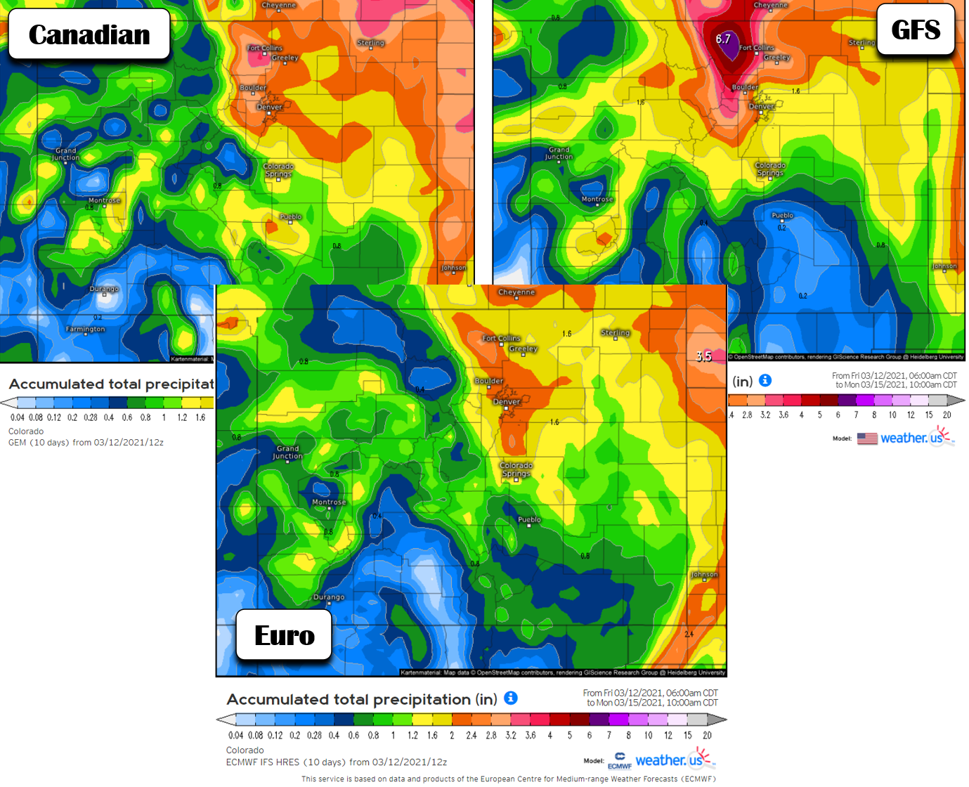
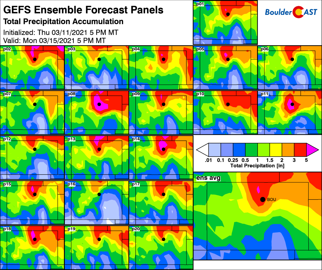
Our storm system continues to evolve in the weather models, which are coming into better overall agreement for the entire Denver Metro area, in some ways. The Friday morning runs of the GFS, Canadian, and European models (shown below) are all predicting around 2″ of moisture from the storm in Denver, with perhaps closer to 3″ in Boulder. This is the best agreement we’ve seen yet for actual precipitation amounts! The massive, unrealistic 6+” bullseye from the GFS model has shifted back slightly northward into Larimer County and Wyoming. In general though, the GFS has come back down closer to reality in our eyes and this is a good sign.
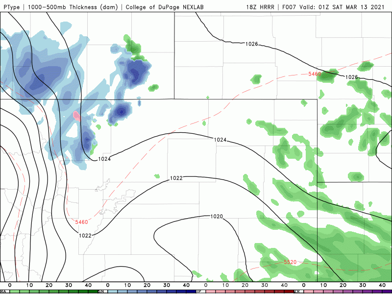
We have concerns about where the dry slot with this storm will end up. There’s always a dry slot! Models are showing quite a bit of variability with this. Boulder looks to be in good shape, but Denver and areas east and southeast may be on the chopping block to see some drier/warmer air work in by Sunday morning. The NAM model (below left) is further north and west with the dry slot, while the GFS (below right) keeps it mostly well southeast of Denver.
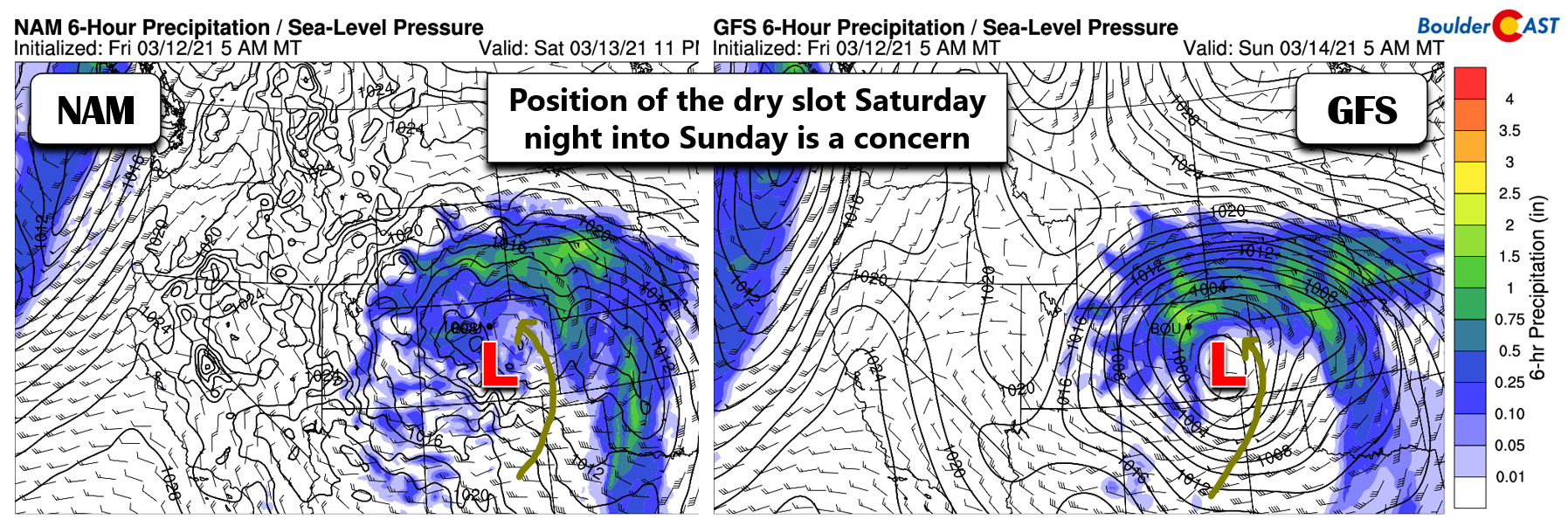
As the GFS ensemble panels highlight below, the dry slot is quite variable and if it pulls too far north, we could see significantly reduced moisture. The western and northern Front Range should be safe from this feature, but areas south and east of Denver have higher uncertainty. The gradient will be intense between Denver and Colorado Springs.
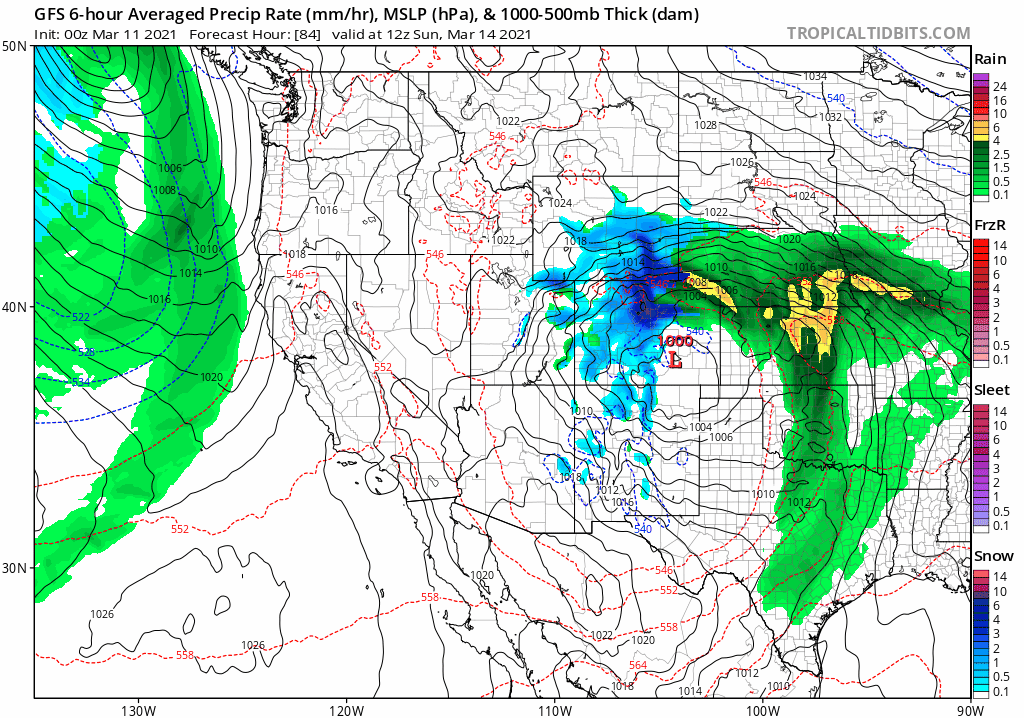
With that said, the main event is on-track to arrive Saturday morning with snow spreading into the area from the south and southeast. Below is an animated precipitation forecast from the high-resolution HRRR model. This particular model only forecasts out to 48 hours, so this animation spans from Friday night only until midday Sunday. Lots of snow (and heavy snow at that!) will impact the Boulder-Denver area. It will be a rain/snow mix across the Plains of northeast Colorado where temperatures will be just a hair too warm. This animation also clearly demonstrates the dry slot working into the Front Range, though it does seem to be overdoing it a little on Sunday. That is, hopefully overdoing it….
We also must mention that some models are still coming in on the warmer side, mainly the GFS model. It has been running too warm for the last few days and refuses to accept that it will snow during the day Saturday, staying just a shade too warm resulting in a chilly rain. Below is a forecast trend animation from the GFS over the last 2 days (8 model runs). This model’s projected rain/snow line sits right over the Denver Metro almost the entire event. If this happens, this snowstorm would be a rainstorm instead! Since just about every other model is colder and almost exclusively snowy for us, we’re disregarding the GFS precipitation type forecast. However, disregarding it doesn’t remove it from the back of our minds and make us any less nervous that the GFS is making this prediction in the first place.
Now that we’ve covered the potential elements that could contribute to a bust (low odds), let’s talk about the storm timeline. That has not changed much since our update yesterday. The heaviest snow and worst impacts are still expected Saturday afternoon into early Sunday when snowfall rates of 1 to 2″ per hour will be widespread across the Denver Metro area. That is extremely heavy snow which no road crews could ever hope to keep up with. Please don’t try to be a “travel hero” this weekend! Just stay home…
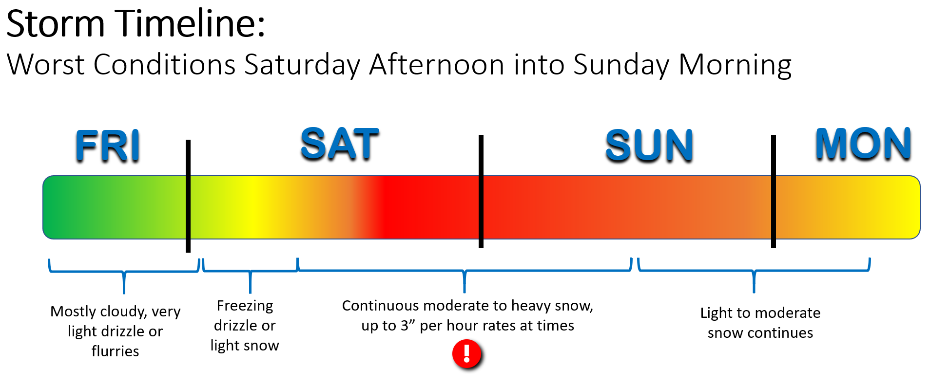
Don’t overlook the fact that this is a long duration, weekend-crashing type of event. From the first freezing drizzle or snowflakes early Saturday, this storm will be dumping snow across the area for nearly 48 continuous hours well into Sunday night or early Monday morning (pending major dry slotting). Don’t expect to see your allocated amount of snow on the ground immediately, or even when things wrap up at the end of the storm. There will be plenty of melting throughout, especially early on during the day Saturday when temperatures are warmer (middle 30’s). We’re expecting storm average snow-to-liquid ratios of around 8:1, which is on the soupier side and will take a little more effort to shovel this weekend.
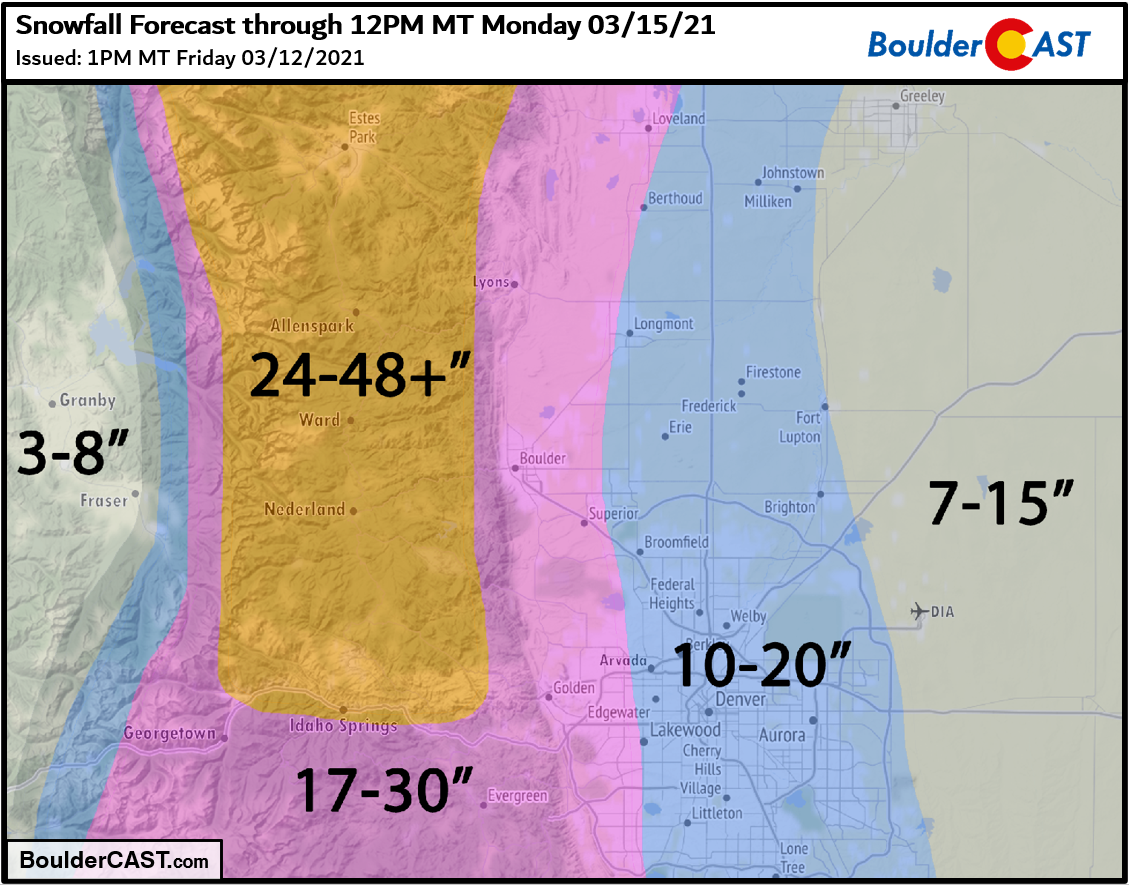
We’re not making any major adjustments to our snowfall forecast at this time, despite a lot of concerns floating around that this storm could be a bust! This our our current thinking….
- Boulder and the far western suburbs of Denver: 17-30 inches
- Denver area: 10 to 20 inches, but lower east
- Foothills above 6000 feet elevation: 2 to 4 feet (locally up to 6 feet in Larimer County)
Overall Forecast Confidence: Medium
Our updated snowfall forecast map for the event is shown below. This covers every bit of snow falling from Friday night through Monday morning.
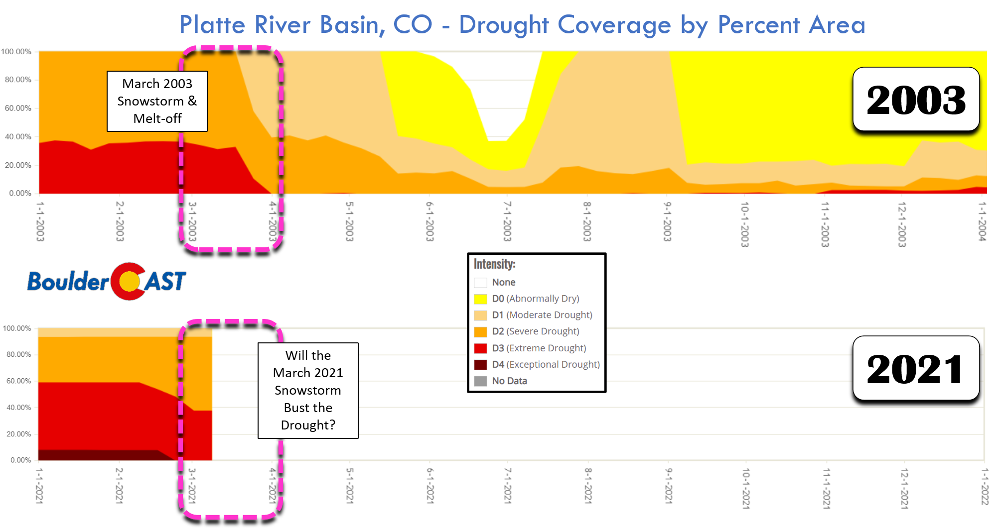
The bottom line, this is a major winter storm for the Front Range. While there is a low chance it could underperform in spots, don’t underestimate this storm! This baby has all the ingredients to produce big snow across the Front Range, which could land in the “top 5” for many cities. With the ongoing severe drought, this will be an absolutely critical event for all of northeast Colorado, with ~15% of our annual precipitation up for grabs this weekend, should even an average blend of the models come to fruition. The historically massive snowstorm back in March 2003 rescued the Front Range from a severe drought then. Let’s hope this one, almost 18 years later to the day, can work some magic as well!
We’ll continue to monitor the situation overnight and may post our final thoughts on the storm sometime Saturday morning. Let’s sit back and see how this much-anticipated, amazing storm plays out!
Place your bets! How much snow is #Boulder going to get from this storm?
30.0" would be a new single storm record for the city#COwx #Snowmageddon2021 @bouldercolorado @CUBoulder
— BoulderCAST Weather (@BoulderCAST) March 13, 2021
REMINDER: This storm needs to break 22.5″ to be a Top 10 contender for Boulder. This is possible, though not a guarantee. Below is a listing of Boulder’s Top 11 snowstorms since 1948.
29.9″ 10/24/1997 –> 10/26/1997
26.0″ 4/7/1959 –> 4/11/1959 (likely was two storms)
26.0″ 12/20/2006 –> 12/21/2006
25.9″ 3/29/1970 –> 3/31/1970
24.0″ 11/20/1979 –> 11/21/1979
23.0″ 5/5/1978 –> 5/6/1978
23.0″ 10/28/2009 –> 10/29/2009
22.9″ 4/2/1957 –> 4/3/1957
22.7″ 2/3/2012 –> 2/4/2012
22.5″ 3/18/2003 –> 3/19/2003
22.5″ 11/25/2019 –> 11/26/2019
NOTE: This historical context only applies back to ~1950 when reliable daily snowfall observations for Boulder became available. Storm totals were derived by summing consecutive days with reported snowfall.
Check back or subscribe to get notified instantly when our forecast updates go live:
We respect your privacy. You can unsubscribe at any time.
Help support BoulderCAST and save 25% with promo code HEAVYSNOW
Help support our team of Front Range weather bloggers by joining BoulderCAST Premium. We talk Boulder and Denver weather every single day. Sign up now to get access to our daily forecast discussions each morning, complete six-day skiing and hiking forecasts powered by machine learning, first-class access to all our Colorado-centric high-resolution weather graphics, bonus storm updates and much more! Or not, we just appreciate your readership!

.
Spread the word, share the BoulderCAST forecast!
.


You must be logged in to post a comment.