
In today’s update we fine-tune the timing of the storm as it is now anticipated to progress more slowly through the region. This has delayed the onset of the snow, but in the end will lead to a longer duration storm. Projected snowfall totals haven’t changed a lot since yesterday, but let’s walk through the latest!
UPDATE (Fri 3/12/21 7:00AM): The recent rounds of model updates continue to support heavy snow this weekend across the Front Range, however snowfall totals have trended downward slightly as models are coming into better agreement. We discuss this and more in Friday morning’s Premium weather discussion, found HERE.
At a Glance:
- A monster winter storm is expected to impact the entire Front Range this weekend, from Colorado Springs northward to Wyoming
- The storm is now anticipated to progress more slowly through the region. This has delayed the onset of the snow, but in the end will lead to a longer duration storm
- The weather models are still quite divisive on snow amounts, so forecast confidence has not increased
- The worst of the snow will develop Saturday afternoon and continue into Sunday afternoon, with lighter snow lingering into Monday morning
- The overall message is unchanged: This will be a historic winter storm for the Front Range with snowfall measured by the foot, not inches! Begin your preparations now and don’t plan to travel too far this weekend! It will likely be impossible.
Help support our team of Front Range weather bloggers by joining BoulderCAST Premium. We talk Boulder and Denver weather every single day. Sign up now to get access to our daily forecast discussions each morning, complete six-day skiing and hiking forecasts powered by machine learning, first-class access to all our Colorado-centric high-resolution weather graphics, bonus storm updates and much more! Or not, we just appreciate your readership!

Slow and steady!
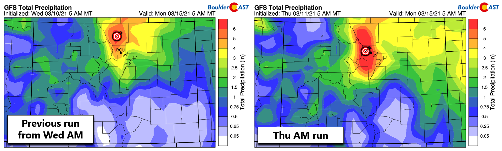
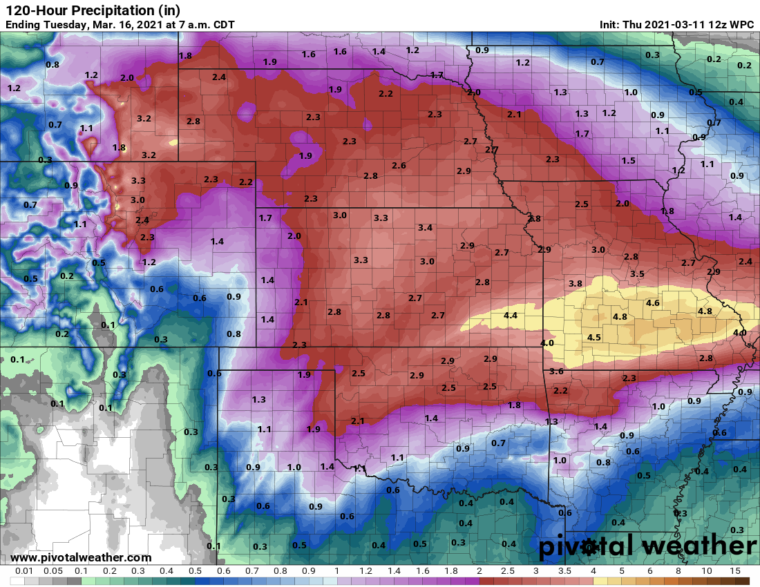
If our forecast update yesterday, in which we mentioned a northward trend in the track of the storm, got you sweating that this ultimately would be a flop for the Front Range, we have some good news today! The northward trend has not continued, and in many ways has reversed back southward to a more favorable position for the whole of the Denver Metro area to get clobbered with lots of snow. Both the GFS and European models have the storm tracking in a prime location across southeast Colorado, whereas yesterday it was closer to east-central Colorado. The bullseye of heaviest precipitation remains solidified across the western Front Range. One example can be seen by comparing the GFS model precipitation forecast from yesterday and today (shown below). The bullseye is back after a brief hiatus!
The main forecast update we’re going to discuss with you today are changes to the entire timing of the storm. It’s not a big adjustment, we promise, but models are starting to come into agreement for a less progressive storm. This means that things will indeed be slower to develop across the Front Range, so Friday now looks like a pretty good day, all things considered. However, once the ingredients do come together, they will persist for longer. For what it’s worth, in these Four Corners Low scenarios, a slower storm is almost always a snowier storm.
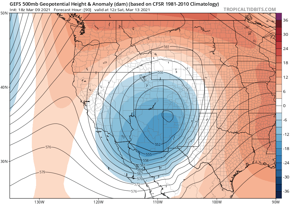
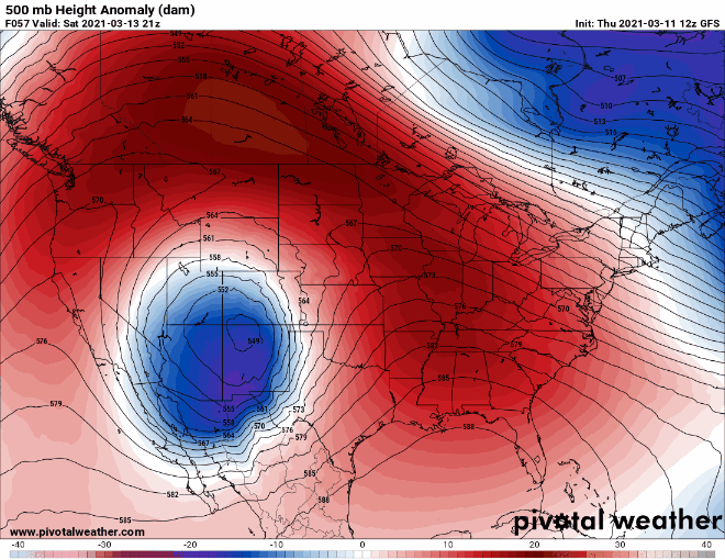
Shown below is the GFS ensemble mean forecast trend for the storm’s position Saturday morning. Notice that as the animation plays out, the center of the storm slowly drifts westward. Since this is a forecast for a fixed time (Saturday morning), this signifies a slowing trend in the models.
The same slowing pattern is observed in forecast trends for the storm’s position on Sunday morning….
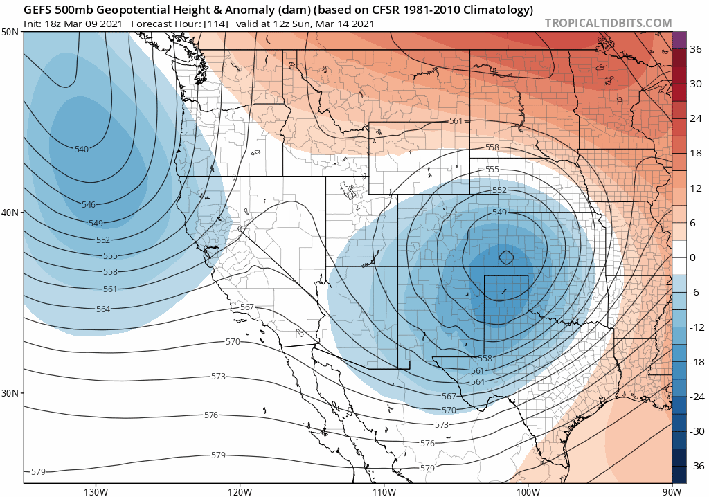
Why is our storm slowing down? Well, it has become “trapped” in a very sluggish weather pattern. The split-flow setup that has established in the atmosphere across North America right now has created a scenario where a strong low pressure (our winter storm!) is directly south of strong high pressure. That big red ridge in Canada is very anomalous…with parts of central Alberta forecast to approach 70°F this weekend, while Denver will be buried in snow. This atmospheric configuration is typically very sluggish and the trapped low pressure can often linger much longer than models expect. This pattern is the foundation of our winter storm, and today we are reminded of what’s really dictating our eventual snow totals.
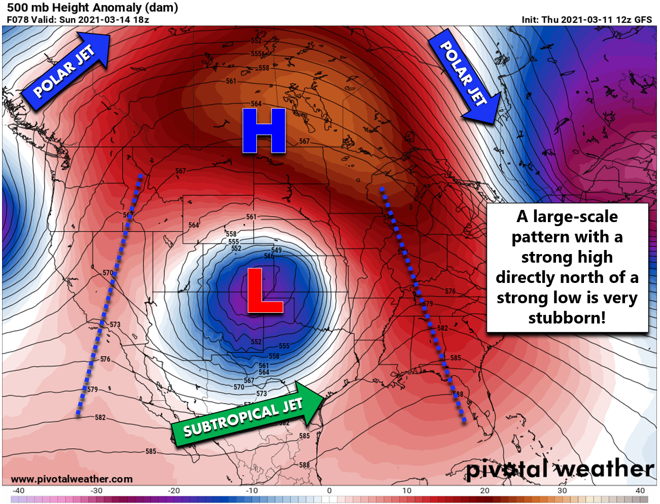
Just look at how slow that wobbling cut-off low is forecast to move this weekend. This animation spans from Saturday afternoon until Monday morning.
Timeline
Given this slower storm, we’re now looking at a new timeline, so do adjust accordingly:
- Friday: Upslope begins across the Front Range with gloomy conditions and a light rain/snow mix developing through the day. Low clouds, fog, and drizzle will be common in and near the Foothills. Very little to no snow accumulation is expected with highs in the middle to upper 30’s.
- Saturday: There will be an uptick in light snow Friday night, but things really get cranking by late Saturday morning or afternoon as everything aligns. Snowfall could be heavy at times and will be continuous once it starts. Temperatures will be near of just above freezing during the day so despite the heavy snow falling, there will be signifiant melting ongoing. At this time, due to the heavy nature of the precipitation and the added cooling that creates, we don’t expect rain to enter the mix (despite what some models want us to believe). It should be all snow for the entire Denver Metro area…and a wet snow at that!
- Saturday night: Heavy, heavy snow is expected through the entire night with snowfall rates of 1 to 3″ per hour common if not widespread. Road crews will not be able to keep up with this storm, especially if the heaviest of the snow persists for 18+ hours like many models are showing. Travel will likely become impossible in spots, perhaps everywhere during this window. Temperatures will drop into the 20’s so there will be less melting. Snow-lovers will be in their happy place during the overnight!
- Sunday: Moderate to heavy snow will continue into the morning hours, if not the afternoon. Eventually snow will begin to decrease in intensity later in the day, but should still persist and be widespread well into Sunday night or early Monday.
Snow Amounts
We continue to see some division in the amount of moisture this storm will put down across the Front Range. In fact, the two major models we look at, the GFS and the Euro, have migrated even further apart, to our great dissatisfaction. On the high-end, the GFS is back to suggesting 3 to 6″ of moisture for the Metro area. This is similar to its prediction early in the week, but it had previously come down a little in the last few days.
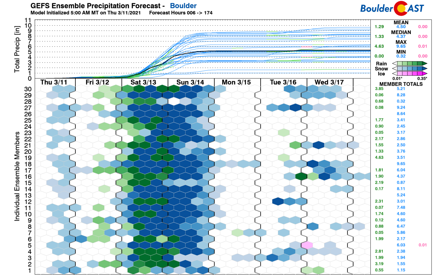
The problem remaining is that the GFS ensembles are just as insanely high, as they have been all along. Usually if the main-line operational GFS is out to lunch, the ensembles can clearly tell us. That’s not the case for this storm. Just look at the slew of ensemble predictions for Boulder. The median precipitation amount is now up to 5.3″ (2″ higher than 48 hours ago). Furthermore, nearly 20% of the ensemble members produce over 8″ of liquid in the city. As mentioned earlier, ignore the green shading as we don’t believe rain will be a factor in this storm at this time.
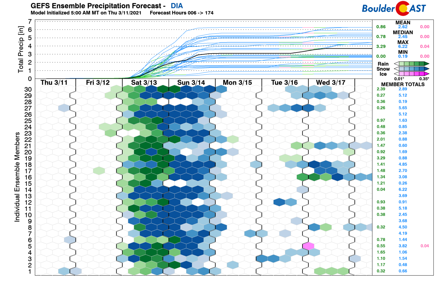
While the raw amounts predicted by the GFS at Denver International Airport are lower than Boulder, the mean of 3.1″ is still very high compared to other model guidance.
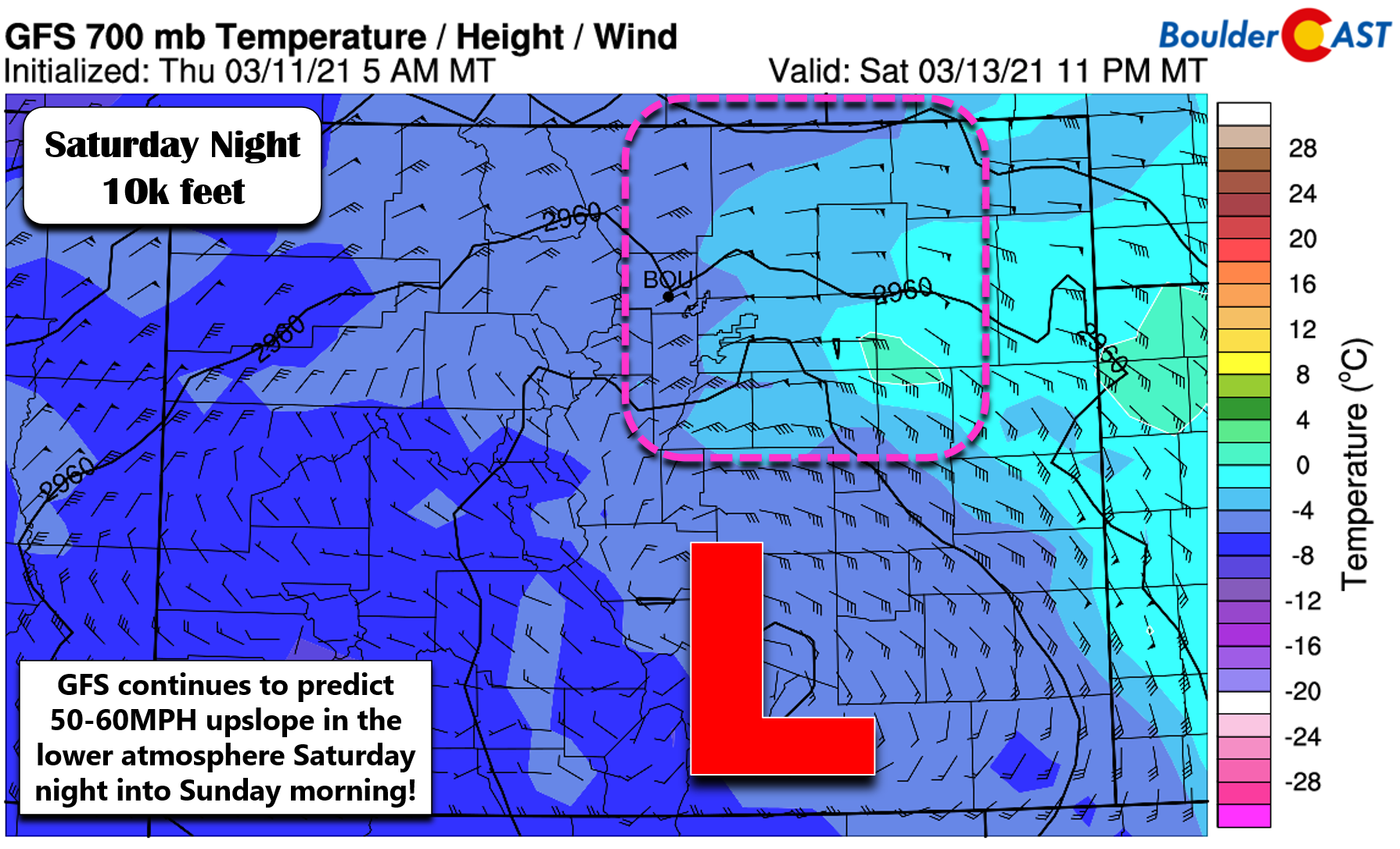
As much as the GFS seems to be on its own desolate planet right now, it can’t be completely discounted. It’s been too persistent for too long in our opinion. It’s not a mystery why the GFS is crushing the snow totals this weekend either. The model is placing and intensifying the storm in south-central Colorado which results in absolutely bonkers upslope wrapping back directly into the Front Range. We’re talking 50 to 60 MPH easterly winds in the lower atmosphere for a very long period of time…something like 18 to 24 hours! Is upslope this strong lasting that long even possible? Sure… maybe only once or twice a century, though. At this point it’s not clear to us or anyone if it will really happen this weekend or not. It’s definitely something to keep in mind as a “the worst case scenario.”
At the moment, a more realistic take on the storm’s potential moisture comes from the blended solution offered by the Weather Prediction Center. Their model blend has around 2.5″ in Denver and 3.5″ of liquid in Boulder. This is a much more reasonable and safer forecast. Again, we’re keeping the booming potential of this storm in the back of our mind.
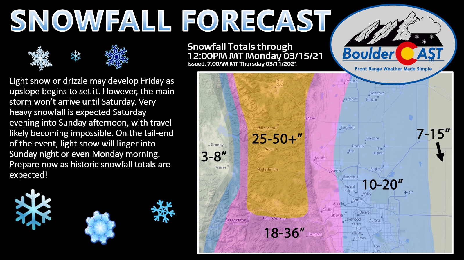
At this time, we’re only making slight adjustments to our projected snowfall totals from yesterday. It’s just too uncertain right now to attempt anything more drastic with them. The main change was to bump up amounts a little in the western Metro area, including Boulder.
- Boulder and the far western suburbs of Denver: 18 to 36 inches
- Denver area: 10 to 20 inches, possibly a little lower in the far east and southeast
- Foothills above 6000 feet elevation: 2 to 4 feet (locally 6 feet in Larimer and Boulder Counties)
Overall Forecast Confidence: Medium
Our PRELIMINARY snowfall forecast map for the event is shown below. This map covers all snow falling from Friday through Monday. We will likely be fine-tuning this map in the coming days. We’ll leave the potential impacts up to the experts, but they could certainly include impassible roadways, power outages, downed trees, and collapsed structures in some areas.
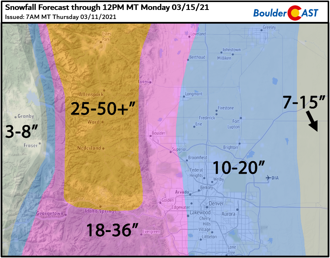
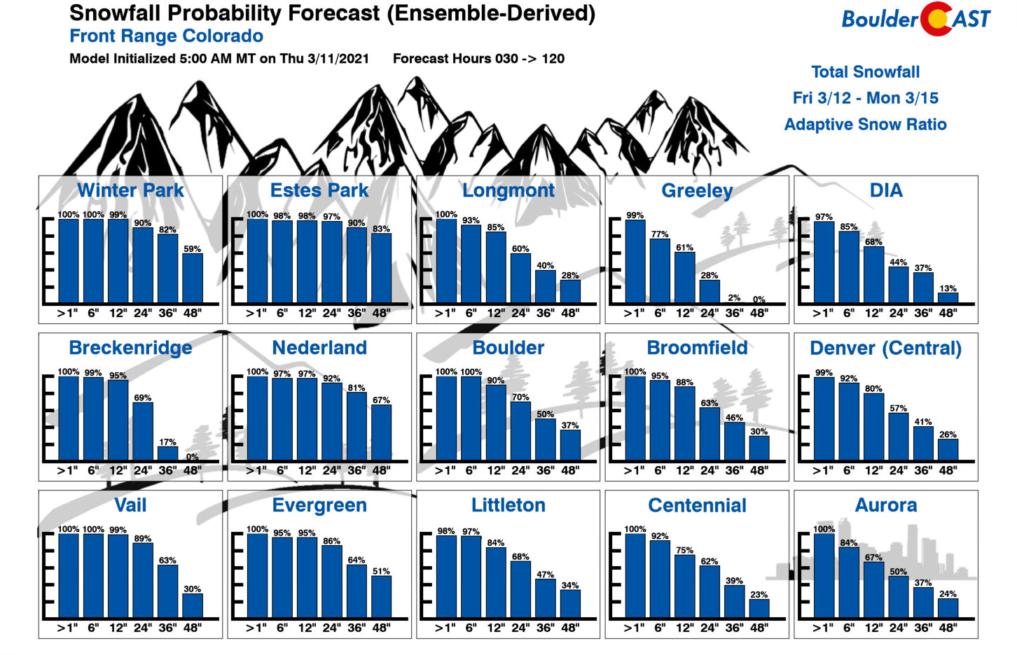
Note that our current forecast still has some degree of conservatism present. We’re not ready to pull the trigger on the high-end, worst case scenario situation yet, but that’s still an outcome with a non-zero chance… as our Snowfall Probability Charts continue to suggest…
REMINDER: We don’t necessarily like to count our chickens before they hatch, but…..should this storm deliver on its promises, it could easily go down as one of Boulder’s biggest snowstorms, if not THE biggest. Below is a listing of Boulder’s Top 11 snowstorms since 1948.
29.9″ 10/24/1997 –> 10/26/1997
26.0″ 4/7/1959 –> 4/11/1959 (likely was two storms)
26.0″ 12/20/2006 –> 12/21/2006
25.9″ 3/29/1970 –> 3/31/1970
24.0″ 11/20/1979 –> 11/21/1979
23.0″ 5/5/1978 –> 5/6/1978
23.0″ 10/28/2009 –> 10/29/2009
22.9″ 4/2/1957 –> 4/3/1957
22.7″ 2/3/2012 –> 2/4/2012
22.5″ 3/18/2003 –> 3/19/2003
22.5″ 11/25/2019 –> 11/26/2019 –> Read our storm recap HERE
NOTE: This historical context only applies back to ~1950 when reliable daily snowfall observations for Boulder became available. Storm totals were derived by summing consecutive days with reported snowfall.
We’ll continue to monitor the situation as this major winter storm approaches in the coming days. We’ll certainly be narrowing down our snowfall forecast ranges further and the timeline as models come into better agreement. Look out for at least two more updates from us before the main event starts on Saturday. Who knows exactly what Mother Nature will have in store for us. More to follow…
Check back or subscribe to get notified instantly when our forecast updates go live:
We respect your privacy. You can unsubscribe at any time.
Help support BoulderCAST and save 25% with promo code HEAVYSNOW
Help support our team of Front Range weather bloggers by joining BoulderCAST Premium. We talk Boulder and Denver weather every single day. Sign up now to get access to our daily forecast discussions each morning, complete six-day skiing and hiking forecasts powered by machine learning, first-class access to all our Colorado-centric high-resolution weather graphics, bonus storm updates and much more! Or not, we just appreciate your readership!

.
Spread the word, share the BoulderCAST forecast!
.


You must be logged in to post a comment.