
The weather pattern across the western United States stays exceedingly active throughout the week ahead with impacts across Colorado ranging from Mountain snow, to cooler than normal temperatures, to elevated fire danger to days of strong downslope winds. Here in the Front Range, we will catch a little bit of everything this week. Read on for all the details.
This week’s highlights include:
- Active Weather Pattern: The western United States, including Colorado, will experience an active weather pattern this week with mountain snow, cooler temperatures, and strong winds.
- Windy Early Week: Winds will be the story early in the week. Gusts up to 75 MPH possible Monday, up to 45 MPH Tuesday and up to 30 MPH Wednesday.
- Mountain Snow: Two waves of snowfall combined with gusty winds will create winter driving conditions in the Mountains through Tuesday
- Temperature Trends: Temperatures will remain steady through the week with highs in the middle 50s to lower 60s. We will warm up for the upcoming weekend, though!
- Precipitation Chances: There’s a good chance for light rain and drizzle late Wednesday into Thursday, with the possibility of late-day showers continuing into the weekend.

DISCLAIMER: This weekly outlook forecast is created Monday morning and covers the entire upcoming week. Accuracy will decrease as the week progresses as this post is NOT updated. To receive daily updated forecasts from our team, among many other perks, subscribe to BoulderCAST Premium.

Go Premium, get all the perks.
Daily Forecast Updates
Get our daily forecast discussion every morning delivered to your inbox.
All Our Model Data
Access to all our Colorado-centric high-resolution weather model graphics. Seriously — every one!
Ski & Hiking Forecasts
6-day forecasts for all the Colorado ski resorts, plus more than 120 hiking trails, including every 14er.
Smoke Forecasts
Wildfire smoke concentration predictions up to 72 hours into the future.
Exclusive Content
Weekend outlooks every Thursday, bonus storm updates, historical data and much more!
No Advertisements
Enjoy ad-free viewing on the entire site.
Active pattern produces Mountain snow & lower elevation wind early week
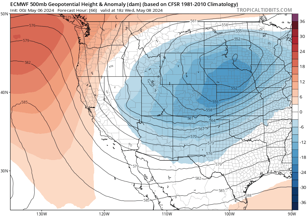
We begin the first full week of May right where the weekend left off with a definitively active weather pattern churning across the western United States. As of Monday morning, a strong cut-off low pressure is spinning to our west in northern Utah. Over the last day or so, this trough has produced late-season accumulating snow in Salt Lake City and near the Grand Canyon — a sign of just how vigorous and cold this system is for early May!
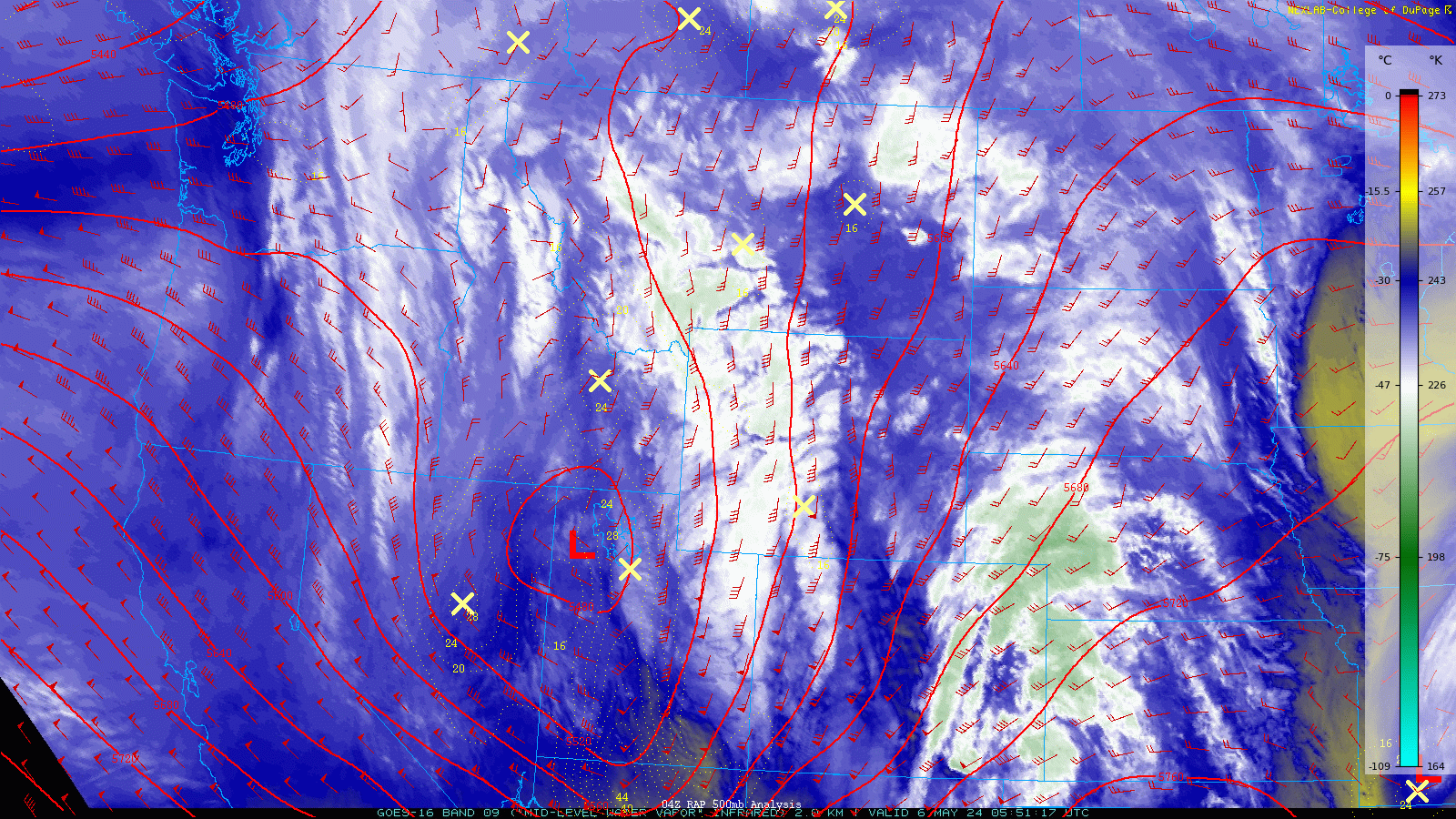
However, as we’ve seen so often of late, the track of this storm will be too far north for the Denver Metro area. We’ll catch mostly just dry downslope winds as it slowly passes through Wyoming before stalling out around the Dakotas. This setup will keep cooler and active weather over Colorado the next few days — expect blustery snow in the Mountains, strong winds on the Plains, and occasional bouts of elevated fire danger, especially south/east of Denver. In the 500mb height anomaly forecast animation below, note how the Utah low pressure drifts northeastward, stalls, and then gets reinforced by a secondary trough coming in from the Pacific Northwest. Whether you like it or not, this large-scale pattern will keep springtime troughing stuck over Colorado all week long!

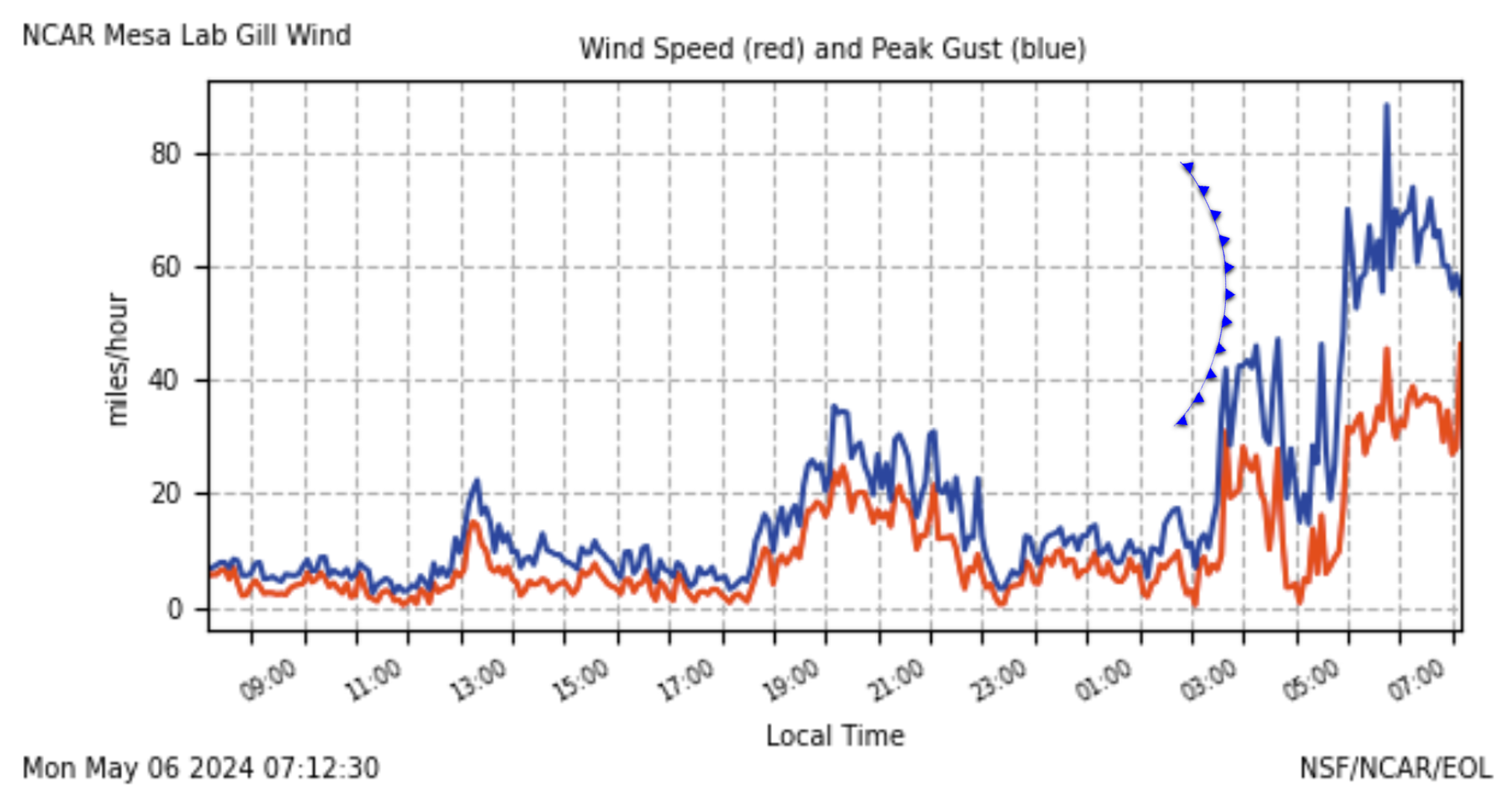
The aforementioned vigorous storm upstream has forced a cold front through the Denver-Boulder area pre-dawn Monday morning from the west — commencing a strong, bora-type downslope wind event for the area. Remember that bora winds are mainly driven by cold dense air crashing down over the Continental Divide behind a cold front, rather than our more typical mountain wave windstorms which are mainly driven by stability and strong winds aloft. Gusts close to 85MPH have already been reported just up the hill from Boulder Monday morning!
The giant graduation tent at CU Boulder took windy hit Monday morning. Hopefully the winds relax enough for this to be fixed before graduation on Thursday!
Wind gusts over 60 MPH did some work on this tent at CU Boulder this morning! 💨🎪 #COWx #Boulder #Boulderwx pic.twitter.com/IsiJzIKWjl
— BoulderCAST Weather 🏔️❄️ (@BoulderCAST) May 6, 2024
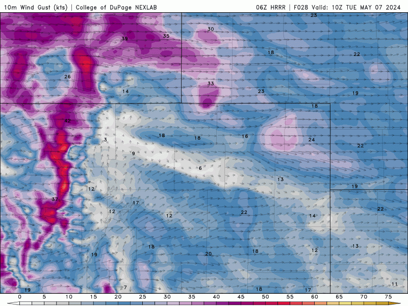
Strong winds will continue throughout all of Monday in the Metro area, with gusts of 40 to 70 MPH common in and near the Foothills, and 25 to 45 MPH in the Denver area. Wind intensity will be waxing and waning throughout the day.
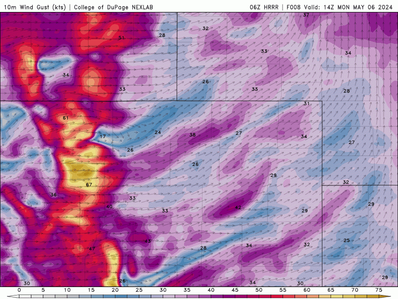
HRRR near-surface wind gust forecast animation spanning all of Monday into Monday night
Expect temperatures to remain steady in the 50s throughout our Monday with west-northwest winds whipping all day long. Hold onto your hats!
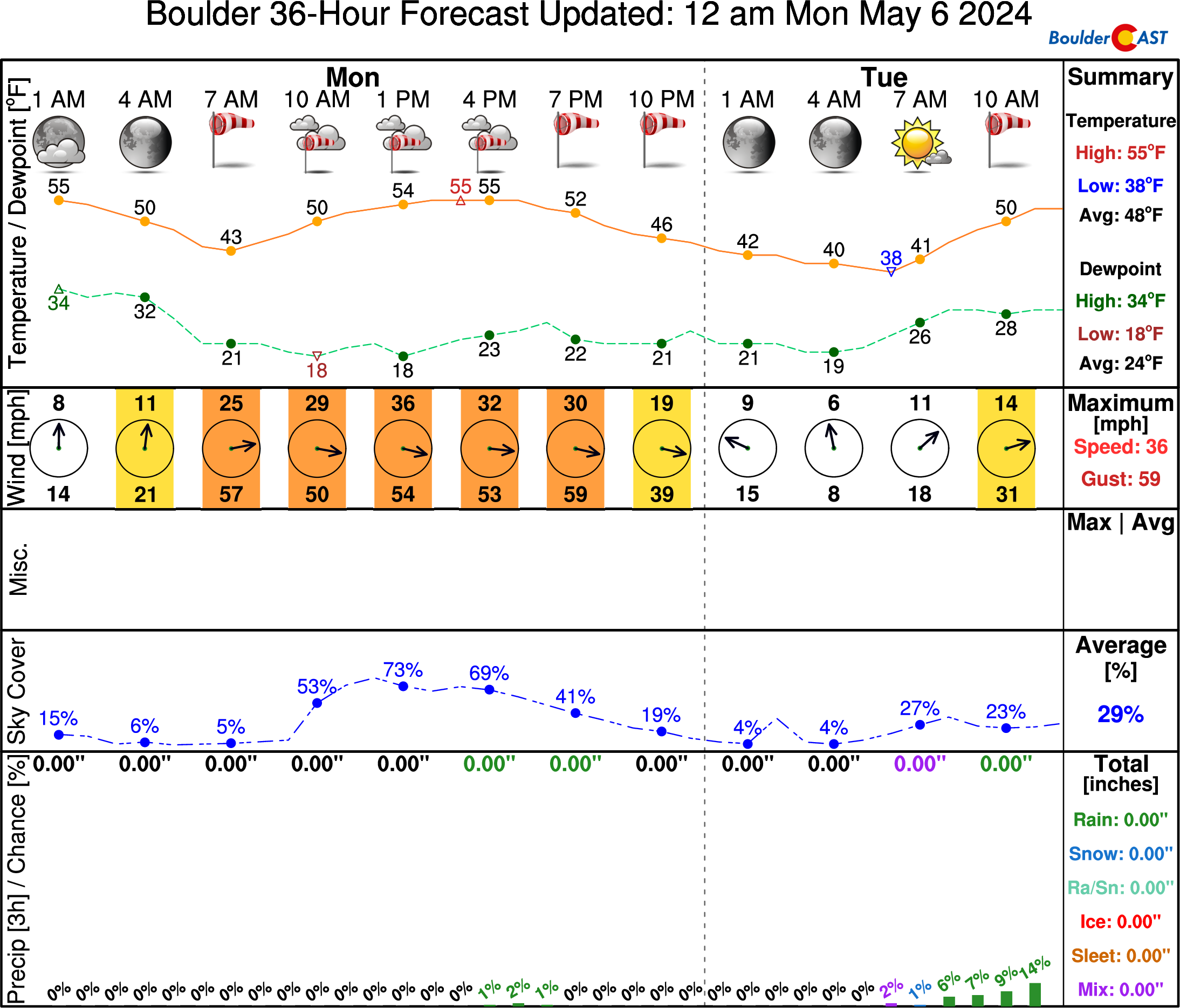
High Wind Warnings remain in effect into late Monday evening for the Foothills and western Metro area, including Fort Collins, Golden and Boulder. Winds are expected to begin relaxing Monday night, though this welcomed reprieve will only be short-lived…

By Tuesday, cross-barrier flow will remain strong across the Front Range with the big trough still stalled out to our north. The bora winds will relax, but daytime mixing will cause another surge of gusty winds from late morning into the early evening. West-northwest winds will gust 25 to 45 MPH much of Tuesday with temperatures only topping out around 60 degrees. An almost identical set of weather conditions will unfold on Wednesday but with less intense daytime winds and highs staying near 60 degrees.
HRRR near-surface wind gust forecast animation spanning all of Tuesday into Tuesday night
Moisture in the westerly flow aloft and lift from the trough will produce several inches of snow in the Mountains early in the week, with snowflakes coming in two distinct waves — one Monday into Monday evening and a second during the day Tuesday. Snowfall totals over a foot are expected in the higher peaks, with lesser totals of a few inches down as low as 8000 feet.


Though the snowfall won’t be terribly heavy, travel impacts will be exacerbated by the accompanying strong winds. Between the falling and blowing snow, plan for winter driving conditions in the Mountains statewide Monday and Tuesday!

Staying active late week, but with actual precipitation chances!
Towards the back half of the week, the pattern will become more favorable for actual precipitation in the Front Range as a stronger cold front pushes into the area. The stalled out low pressure in the Dakotas will slowly dissipate while at the same time a weak trough elongates back westward across Colorado and into the Desert. This will allow for a better push of low-level moisture from the northeast, likely spawning a period of upslope precipitation in the Denver Metro area.
The first and best chance of precipitation for the week comes Wednesday evening through Thursday evening — an excellent chance of rain overall but for only low-end amounts. We’re talking mostly light rain and/or drizzle — nothing major or soaking. Almost every ensemble member produces less than 0.15″ of rain Thursday for us. Highs on Thursday will only be in the 50s with gloomy skies accompanying the raindrops.

The weak trough axis will remain over Colorado into the upcoming weekend. While there will only be minor large-scale lift available from this trough, enough moisture will linger along this trough axis for at least a chance of late-day showers every day firing from springtime instability. Temperatures will be trending back towards normal this weekend as well with 70s possible as early as Saturday. Enjoy!
Get BoulderCAST updates delivered to your inbox:
Forecast Specifics:
Monday: Partly to mostly cloudy and very windy. Winds gusting from the west-northwest 45 to 75 MPH in and near the Foothills, with 25 to 45 MPH in Denver. A few rain/snow showers will impact areas of the Foothills with only light accumulations above 8000 feet. Highs in the 50s on the Plains with near 40 in the Foothills.
Tuesday: Partly cloudy with downslope winds ramping up through the day again. Gusts of 25 to 45 MPH possible regionwide. Highs reach near 60 degrees on the Plains with upper 40s in the Foothills.
Wednesday: Staying cool and breezy. A late-day cold front will bring a chance of rain/drizzle in the late-day period, mainly after 6PM. High temperatures top out near 60 on the Plains with upper 40s in the Foothills.
Thursday: Cool and gloomy with light rain/drizzle mixed in throughout the day. Highs in the low to middle 50s on the Plains with upper 30s in the Foothills. Light snow accumulations possible in the higher Foothills.
Friday: Quieter and staying cool, though we can’t rule out a spotty rain shower during the day. Expect temperatures to reach near 60 degrees on the Plains with upper 40s in the Foothills.
Weekend: Warmer in the upper 60s to middle 70s for highs with a slight chance of late-day showers both Saturday and Sunday.
DISCLAIMER: This weekly outlook forecast is created Monday morning and covers the entire upcoming week. Accuracy will decrease as the week progresses as this post is NOT updated. To receive daily updated forecasts from our team, among many other perks, subscribe to BoulderCAST Premium.
Go Premium, get all the perks.
Daily Forecast Updates
Get our daily forecast discussion every morning delivered to your inbox.
All Our Model Data
Access to all our Colorado-centric high-resolution weather model graphics. Seriously — every one!
Ski & Hiking Forecasts
6-day forecasts for all the Colorado ski resorts, plus more than 120 hiking trails, including every 14er.
Smoke Forecasts
Wildfire smoke concentration predictions up to 72 hours into the future.
Exclusive Content
Weekend outlooks every Thursday, bonus storm updates, historical data and much more!
No Advertisements
Enjoy ad-free viewing on the entire site.
Enjoy our content? Give it a share!


Today, I’m going with the flow… I don’t have any other choice!
That’s all we can do this week. Can’t get a longer, nice stretch of weather it seems. Random cold fronts, wind storms, and minimal precip to show for it!