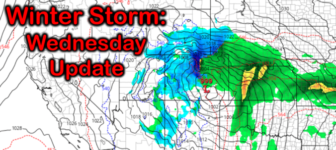
A major winter storm is still on-track for the Front Range, but we’ve got a few updates to share with you that could impact which areas see the most snow. We discuss the latest model trends, our thoughts on this historic storm as it stands now, and highlight what to look out for in the days ahead.
UPDATE (Thu 3/11/21 7:00AM): The recent rounds of model updates continue to support heavy snow this weekend across the Front Range, however the timing has shifted slightly. We discuss this and more in Thursday morning’s Premium weather discussion, found HERE.
At a Glance:
- Heavy snowfall is expected late Friday night into Sunday night as a powerful and expansive low pressure system slowly pushes across southern Colorado
- Deep and moist upslope will produce widespread, heavy, and prolonged precipitation across the Front Range
- Models have shifted the track slightly northward which may wrap warmer air in and cause some rain to mix in on Saturday, but this is still uncertain
- Precipitation will be heaviest Saturday into early Sunday, but could linger into Sunday night
- The overall message is unchanged: This will be an historic winter storm for the Front Range with snowfall measured by the foot, not inches! Begin your preparations now and don’t plan to travel too far this weekend!
Help support our team of Front Range weather bloggers by joining BoulderCAST Premium. We talk Boulder and Denver weather every single day. Sign up now to get access to our daily forecast discussions each morning, complete six-day skiing and hiking forecasts powered by machine learning, first-class access to all our Colorado-centric high-resolution weather graphics, bonus storm updates and much more! Or not, we just appreciate your readership!

W
e’re not going to sugar-coat it for you. There have been a two notable model developments in the last 24 hours that have stalled what was growing confidence in how this highly impactful winter storm will play out through the weekend across the Front Range and Denver Metro area.
First, that track of the large-scale low pressure system has trended about 100 miles further north in the models over the last day or two. We saw hints of this in yesterday’s model runs, and today, this migration has been further confirmed. The graphic below shows the storm’s expected position as of Saturday evening. The top panels are the average of 30 GFS ensemble runs, while the bottom panels are the average of 50 European ensemble runs. The left panels were from yesterday, while the right panels are from today. In the case of both the GFS and Euro, we see the forecast position of the low has shifted northward slightly. The Euro is also moving the system through slower so that’s why it is positioning the low further west on Saturday evening.
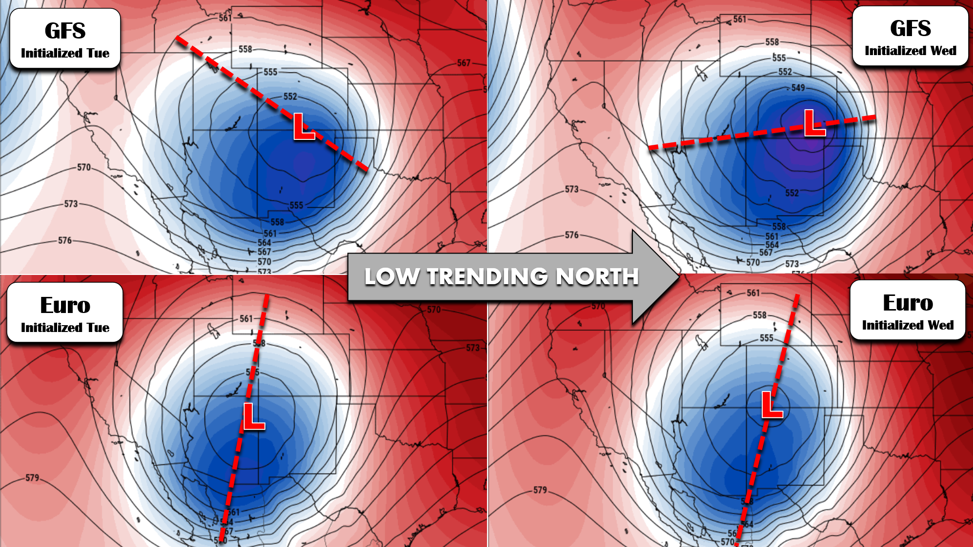
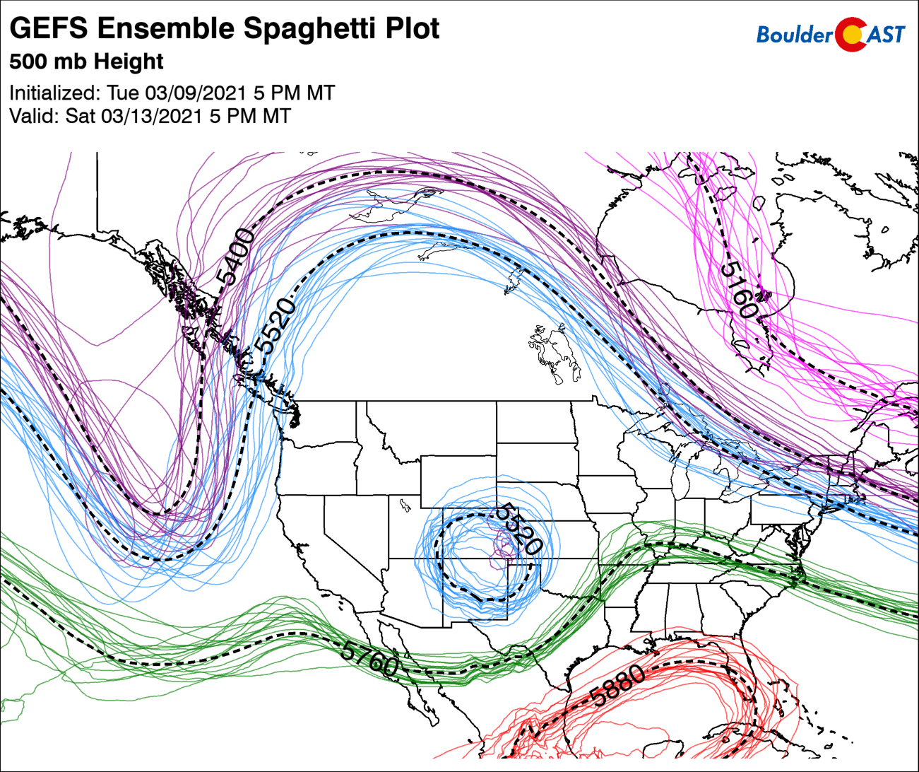
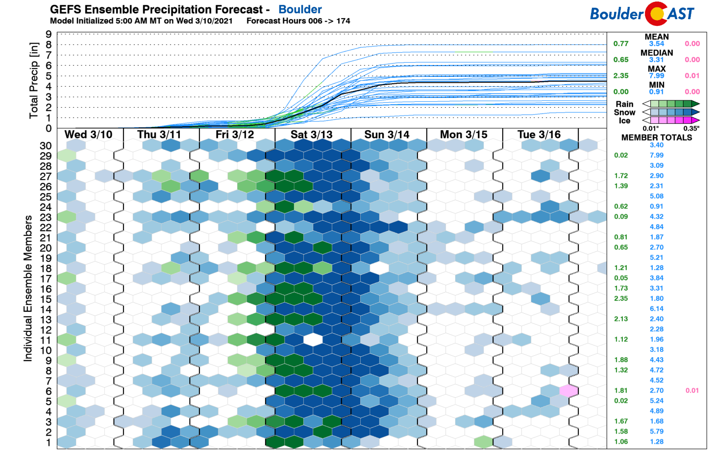
The forecasts above only depict the average position of all the model runs. Looking at individual runs from the GFS below, we see the position of the storm is indeed quite variable (blue circular lines), both in the east-west and north-south directions. There is obviously some uncertainty in the track this far out, but this will go down as we get closer.
As we specifically highlighted in our forecast update on Tuesday, a track shift wouldn’t be that big of a deal-breaker for us due to the storm’s massive scale. The Denver Metro area started out right in the absolute crosshairs of this storm, and even a moderate shift of 100 miles would keep the threat of very heavy snow across our area. Despite the shift, this is still our current thinking today.
The second notable model change is actually a byproduct of the first. With a more northward track, warmer air will get drawn further north and could actually make it into the Front Range on Saturday. The concern is that this warm air could cause some locations to stay as rain for a longer period of time. Of course if it’s raining, it’s not snowing, so this would decrease snowfall totals and make for quite the mess.
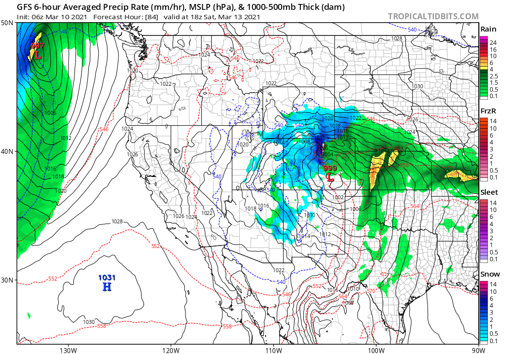
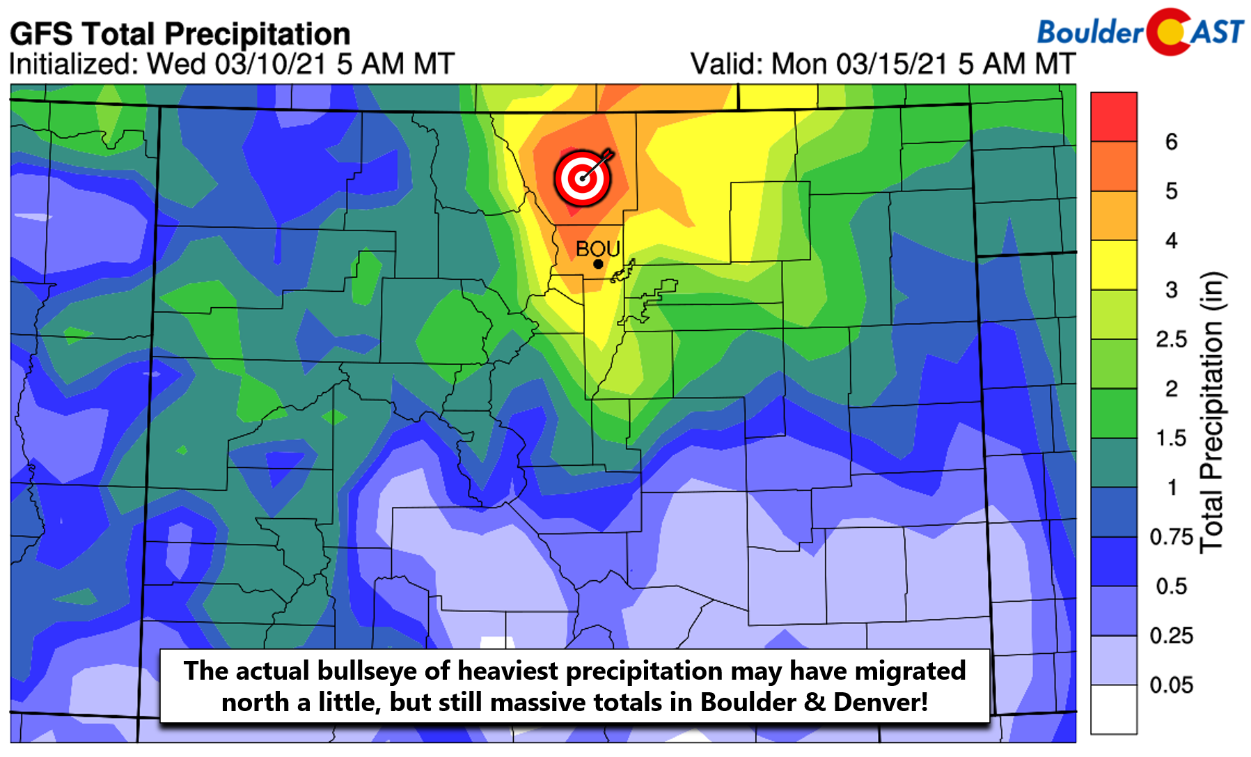
GFS model precipitation forecast for Saturday mid-day. The rain/snow may creep into the Front Range from the east.
A look at the latest GFS ensemble precipitation forecast is concerning. More than half of the 30 members are showing a significant amount of rain Friday night into Saturday afternoon. Note the dark green shading. In many of those cases, more than 1″ of liquid is lost to rain. The good news, even if there is some rain, there will very much still be a hefty dumping of snow afterwards. Furthermore, the ensemble mean has increased to a massive 4.25″ in Boulder in the last few runs (up from about 3.3″ yesterday), boosted primarily by a group of outliers forecasting between 6 and 8″ of liquid from this storm! Wow…can you imagine that?
One final consideration for today’s update concerns the back-end of the event. There are some key model differences on how long the storm lingers across eastern Colorado. The GFS predicts most of the heavy snow will end by early Sunday morning, while the Euro model is less intense overall with the precipitation throughout, but keeps it around longer well into Sunday evening. Two slightly different paths to the same massive pile-up of snow, perhaps. It does seem that most models have been trending slower towards that European solution, so we will favor that for now. This means that a bulk of the precipitation from this storm will begin Friday and may not end until late Sunday night, with devastating travel impacts through the weekend, possibly even into Monday.
With all that said, there will be several things to closely watch in the coming days:
- Will the storm continue to shift further north and take the bullseye of heaviest precipitation with it towards the Wyoming border and Cheyenne?
- How much of that warm, juicy air will make it into the Front Range and literally rain on our snowy parade for a portion of Saturday?
- How long does the snow linger into Sunday?
Right now, we think we’re still in good shape for a massive dumping of snow this weekend, but there are a few wrinkles to work out. We’re over 48 hours from game time! If you’re hoping for epic snow, don’t fret yet. Just about every weather model is still indicating between 10 and 30 inches of snow for the entire Denver Metro area, with up to 6 feet possible in the Foothills. And let’s not forget, there is a tiny chance (but not that tiny) that this storm completely hits it out of the park and dumps 4 feet everywhere as our latest snowfall probabilities may suggest…
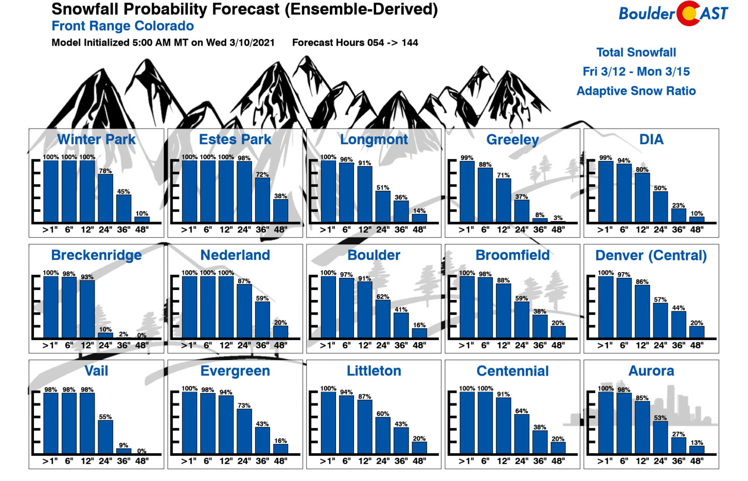
At this time, we’re only making slight adjustments to our projected snowfall totals from yesterday. It’s just too uncertain right now to attempt anything more drastic with them. The main change was to bump up amounts in the Foothills where there will be no threat of rain and snow ratios could be a little higher.
- Boulder and the far western suburbs of Denver: 15 to 30 inches
- Denver area: 10 to 20 inches, possibly a little lower in the far east and southeast
- Foothills above 6000 feet elevation: 2 to 4 feet (locally 6 feet in Larimer and Boulder Counties)
Overall Forecast Confidence: Moderately Low
We don’t necessarily like to count our chickens before they hatch, but…..should this storm deliver on its promises, it could easily go down as one of Boulder’s biggest snowstorms, if not THE biggest. Below is a listing of Boulder’s Top 11 snowstorms since 1948. It will take all 30″of our forecast for the weekend to nab the #1 spot!
-
29.9″ 10/24/1997 –> 10/26/199726.0″ 4/7/1959 –> 4/11/1959 (likely was two storms)26.0″ 12/20/2006 –> 12/21/200625.9″ 3/29/1970 –> 3/31/197024.0″ 11/20/1979 –> 11/21/197923.0″ 5/5/1978 –> 5/6/197823.0″ 10/28/2009 –> 10/29/200922.9″ 4/2/1957 –> 4/3/195722.7″ 2/3/2012 –> 2/4/201222.5″ 3/18/2003 –> 3/19/2003
22.5″ 11/25/2019 –> 11/26/2019
NOTE: This historical context only applies back to ~1950 when reliable daily snowfall observations for Boulder became available. Storm totals were derived by summing consecutive days with reported snowfall.
This is going to be a absolutely critical event for Boulder and the entire Metro area as a whole, with up to 20% of our annual precipitation up for grabs this week, should even an average blend of the models come to fruition. The historically massive snowstorm back in March 2003 rescued the Front Range from a severe drought. Let’s hope this one, 18 years later, can do the same!
We’ll continue to monitor the situation as this major winter storm approaches in the coming days. We’ll certainly be narrowing down our snowfall forecast ranges and the timeline as models come into even better agreement. Stay tuned and begin to make those preparations for FEET of snow!
Check back or subscribe to get notified instantly when our forecast updates go live:
We respect your privacy. You can unsubscribe at any time.
Help support BoulderCAST and save 25% with promo code HEAVYSNOW
Help support our team of Front Range weather bloggers by joining BoulderCAST Premium. We talk Boulder and Denver weather every single day. Sign up now to get access to our daily forecast discussions each morning, complete six-day skiing and hiking forecasts powered by machine learning, first-class access to all our Colorado-centric high-resolution weather graphics, bonus storm updates and much more! Or not, we just appreciate your readership!

.
Spread the word, share the BoulderCAST forecast!
.


You must be logged in to post a comment.