
The secret is out it seems! By now you’ve heard that a major winter storm is heading towards the Front Range. Some weather models are predicting that historic snowfall totals will blanket the area by the end of the upcoming weekend. While forecast confidence is growing, our storm system is still offshore and the main event is still several days away from Colorado. We discuss the latest on the storm, provide details on how the models are trending, and give our (super early) preliminary snowfall forecast.
UPDATE (Wed 3/10/21 7:00AM): The recent rounds of model updates continue to support heavy snow this weekend across the Front Range, however there are a few concerns we have as the storm approaches. We discuss this and more in Wednesday morning’s Premium weather discussion, found HERE.
At a Glance:
- A major winter storm will impact Front Range Colorado Thursday into Sunday. There’s no doubt about this.
- Confidence is growing in the forecast as the track, scale, magnitude and speed of the storm are becoming more clear…and everything points to heavy snow for the Denver Metro area
- There is still considerable uncertainty in the exact timing and snowfall amounts, ranging from just another sizable snow event to something bordering on historic
- The worst case scenario could cripple our area, but even the best case scenario will have major impacts to everyone so do plan ahead!
Help support our team of Front Range weather bloggers by joining BoulderCAST Premium. We talk Boulder and Denver weather every single day. Sign up now to get access to our daily forecast discussions each morning, complete six-day skiing and hiking forecasts powered by machine learning, first-class access to all our Colorado-centric high-resolution weather graphics, bonus storm updates and much more! Or not, we just appreciate your readership!

Historic snow, or just significant snow?
Have you gotten in on the extreme hype surrounding the incoming massive winter storm set to impact the Front Range later this week? We know you have; that’s why you’re here! It is true that a significant winter storm is headed our way, but the headlines thus far have been focused on some of the more fantastical model solutions. Don’t get us wrong, a very strong winter storm will slam Colorado this weekend. There’s no questioning that. We won’t escape the grasp of this low pressure. Arguably, this is the most interesting and intense system we have seen here since the March 2019 Bomb Cyclone just over two years ago. We can confirm….the hype is real. Let’s just keep expectations in check for a storm that is still four days out with plenty of avenues for a major boom or even a backdoor bust!
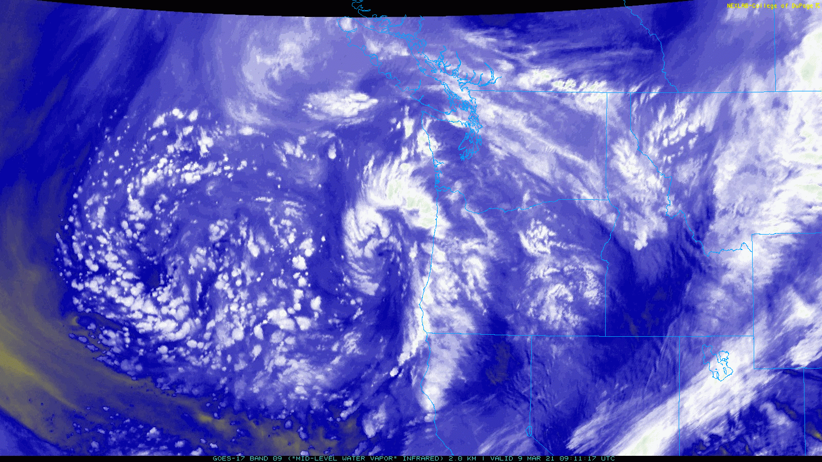
Right now our storm is located offshore of the Pacific Northwest. This morning’s GOES-East water-vapor satellite animation below shows this positioning. The storm still hasn’t cut-off fully from the polar jet stream, so it’s notably a bit disorganized with multiple embedded circulations. This will change in the coming days as the low pressure pinches off and becomes more consolidated as it heads into the southwestern United States.
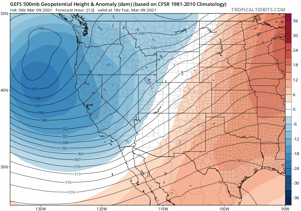
The GFS 500mb height forecast animation below shows the storm’s expected evolution from now through Sunday. This is actually the GFS ensemble mean forecast, the average of 30 different model runs. This ensemble average gives us a reasonable track several days out, indicating that the low will fully cut-off and move into the Four Corners area by Friday night.
The track of the storm is nearly perfect to facilitate a classic Front Range spring precipitation event. The counter-clockwise flow will pull deep Gulf of Mexico moisture back into eastern Colorado from the east and south. The forecast graphic below shows the large fetch of warm and moist air wrapping back into the core of the storm on Saturday. At this time, the GFS model is predicting the storm to be located just south of the actual Four Corners point.

The main reason we have high confidence that this will be a significant winter storm for the Front Range is three-fold.
1…. The general track indicated by most weather models and their ensembles is fairly consistent. Because of this, we already have a pretty good idea where this storm will end up this weekend. For example, shown below is what the European and GFS ensemble means look like for the storm’s positioning Saturday evening. A little bit of difference is noted, mainly that the Euro is simply lagging behind the GFS. Overall, though, we can’t really ask for better agreement five days out on a cut-off system such as this. It’s this large-scale agreement that allows us to discuss with you the finer aspects of the storm with lessened uncertainty.

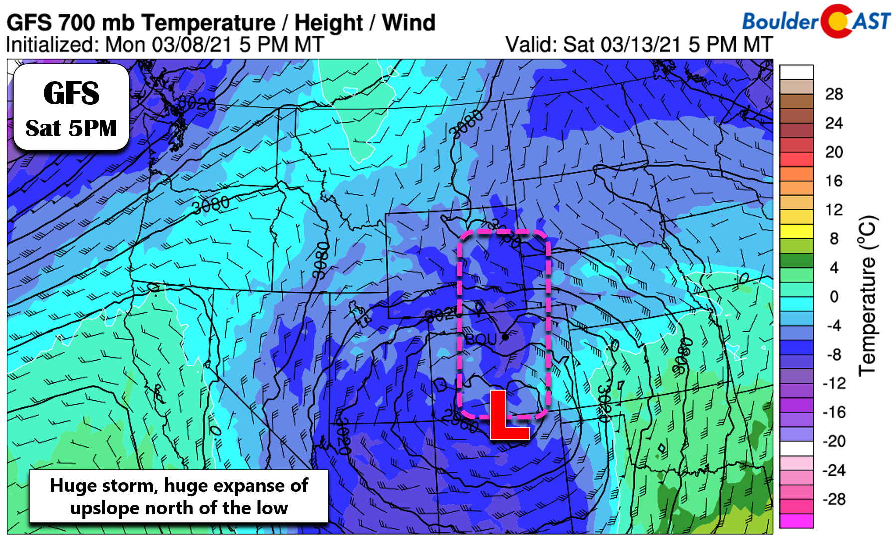
2… The storm will be massive in scale! As we touched on yesterday in our weekly outlook, the shear footprint of the low pressure system will more than make up for any shifts in the track with all of eastern Colorado and southeast Wyoming poised to see a period of intense upslope from this storm. The 700mb temperature and wind forecast below is from the GFS model for Saturday evening. Even though the center of the storm is located well south in northern New Mexico, the upslope regime extends many hundreds of miles northward into Wyoming. If the track does somehow shift north or south by 100 or even 200 miles, we’ll still be just fine.
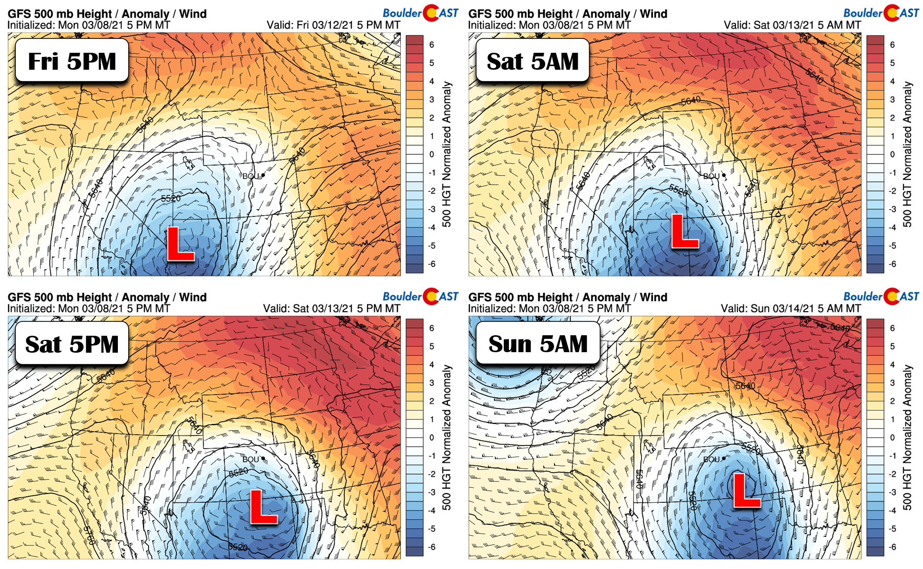
3… The speed in which the storm moves through the area will be very slow. The timeline below shows the storm’s forecast location from Friday evening into Sunday morning. It doesn’t move a whole lot, and slows down even further once it gets into prime position along the New Mexico border. So whatever magnitude and directionality of upslope materializes across eastern Colorado will linger for an extended period. Longer snow is more snow.
The Real Question: How Much!?
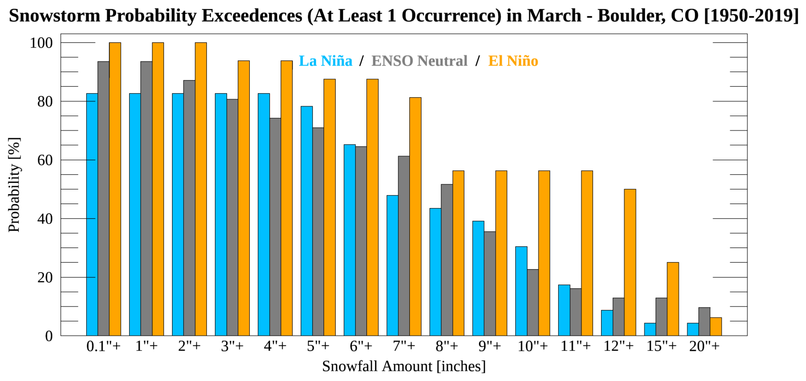
This far out, predicting snow totals is still a colossal challenge. There is no doubt that this will be a significant snowstorm for us. The question is whether it will be a historic one or not… The jury is still out. We have a hard time predicting what would be the biggest La Niña snowstorm in Front Range history, let alone one during the month of March which is typically devoid of snowfall during La Niña. Based on the last 70 years of Boulder climate data, there’s only been one snowstorm that exceeded 15″ in Boulder during La Niña Marches. This count very well could become two this weekend.
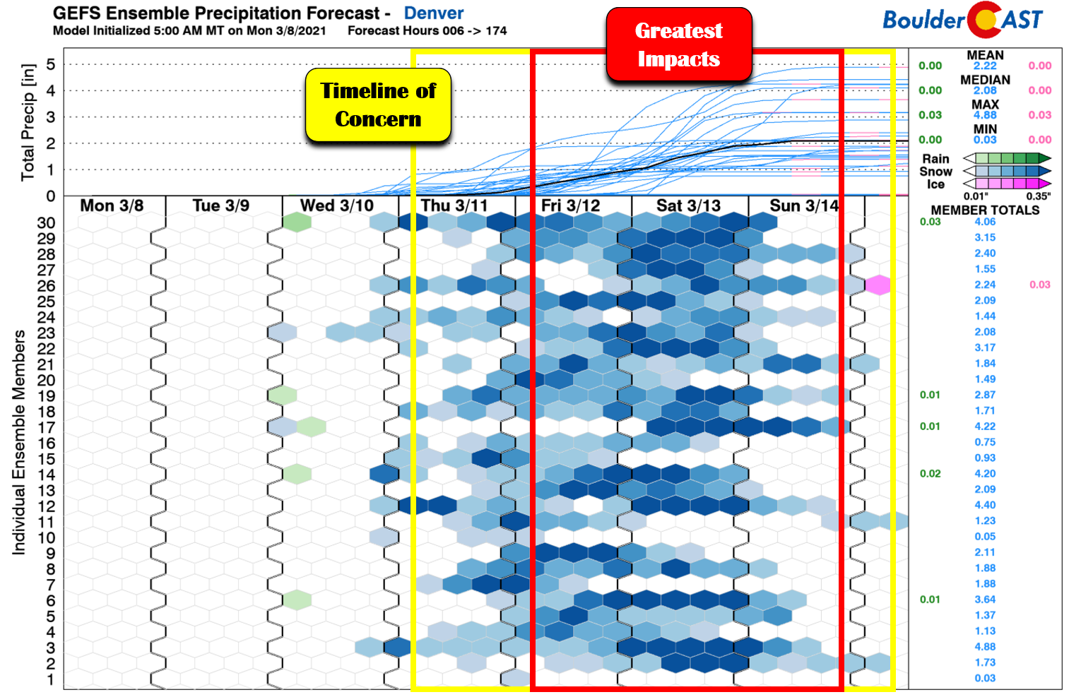
The GFS model and its ensembles continue to produce upwards of 3 to 6 feet of snow in the Denver Metro area by the end of the weekend. We’ve now seen around seven consecutive GFS operational runs produce these staggering totals, which is concerning to say the least.
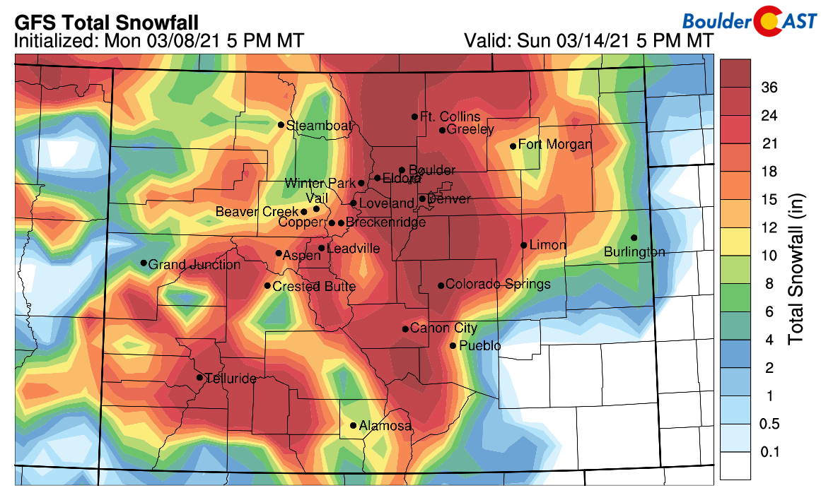
The graphic below shows the snowfall forecast from twenty GFS ensemble members. The larger panel in the bottom right is the ensemble average, which as you can see, dumps around 24″ in Boulder!

Our latest Snowfall Probabilities are equally as impressive, showing an 80 to 90% chance of at least a foot of snow dumping on every city in the Denver Metro area (except Greeley).

The Euro and Canadian models are still less snowy overall, but on average produce anywhere from 1 to 3 feet of snow across the Front Range. Furthermore, the driest bunch of model runs have almost entirely disappeared at this point. There were quite a few stragglers as of yesterday hinting that this storm could somehow slip past our area. That isn’t going to happen. Again, those three key factors we mentioned already are contributing to this shoring up in the models. There’s almost no path forward where the Front Range doesn’t get hammered from this storm system. There’s essentially no chance that Boulder will see less than 10″ from this event, or Denver less than 6″.
The most likely outcome in our opinion has 1 to 2.5 feet falling across the Front Range. On the lower end of this range, it would still be a big storm, but nothing we haven’t experienced many times before, including just two weeks ago. On the higher end, this could be one of the biggest snowstorms in Front Range recorded history. The slow-moving nature of this winter storm will prolong the potential window for snowfall. Right now we can expect accumulating snow from about mid-day Thursday through Sunday evening. The greatest threat for major impacts is expected Friday through Saturday night. Upslope is likely to be occurring during much of this time. When upslope is going in these situations, the snow almost never stops in Boulder, though we could see some breaks in the action further east in Denver.
While we are hesitant to throw out a specific prediction for snowfall amounts this early in the game, we do believe there is enough model agreement to narrow things down to the following ranges at this time…
Preliminary, Still Uncertain Snowfall Forecast Amounts:
- Boulder and the western suburbs of Denver: 13-28″
- Denver area: 8-18″
- Foothills area: 15-30+”
- Mountains: Variable amounts depending on the specific range, but generally 6″ to 2 feet
Overall Forecast Confidence: Still Somewhat Low, But Growing
All things considered, there’s still quite a bit of uncertainty in potential snowfall amounts. However, that uncertainty is really in how many feet will we see, not necessarily how many inches. On the high end, totals of 3 to 5 feet are within the range of possibilities, but not likely at this time. Still, this amount of snow would cripple our area and can’t fully be discounted just yet. So at the very least, we should all begin taking steps to prepare for a “worst case scenario” situation. For the average folk, this might simply mean picking up a few extra groceries or rethinking your weekend plans. For ranchers, choices about livestock considerations will be more critical. Anyone with air or road travel plans should expect major impacts and be prepared to cancel.
We’ll continue to monitor the situation as this major winter storm approaches in the coming days. We’ll certainly be narrowing down our snowfall forecast ranges and the timeline as models come into even better agreement. That’s all for now. It’s going to be a very busy week in Colorado weather!
Check back or subscribe to get notified instantly when our forecast updates go live:
We respect your privacy. You can unsubscribe at any time.
Help support BoulderCAST and save 25% with promo code HEAVYSNOW
Help support our team of Front Range weather bloggers by joining BoulderCAST Premium. We talk Boulder and Denver weather every single day. Sign up now to get access to our daily forecast discussions each morning, complete six-day skiing and hiking forecasts powered by machine learning, first-class access to all our Colorado-centric high-resolution weather graphics, bonus storm updates and much more! Or not, we just appreciate your readership!

.
Spread the word, share the BoulderCAST forecast!
.


You must be logged in to post a comment.