
We provide a quick update on the situation this morning as Mother Nature is about to unleash on the Front Range! The potential for a bust has decreased and snowfall amounts have trended up overnight in the models. Let’s run through the latest.
Help support our team of Front Range weather bloggers by joining BoulderCAST Premium. We talk Boulder and Denver weather every single day. Sign up now to get access to our daily forecast discussions each morning, complete six-day skiing and hiking forecasts powered by machine learning, first-class access to all our Colorado-centric high-resolution weather graphics, bonus storm updates and much more! Or not, we just appreciate your readership!

Receive BoulderCAST updates as soon as they go live…
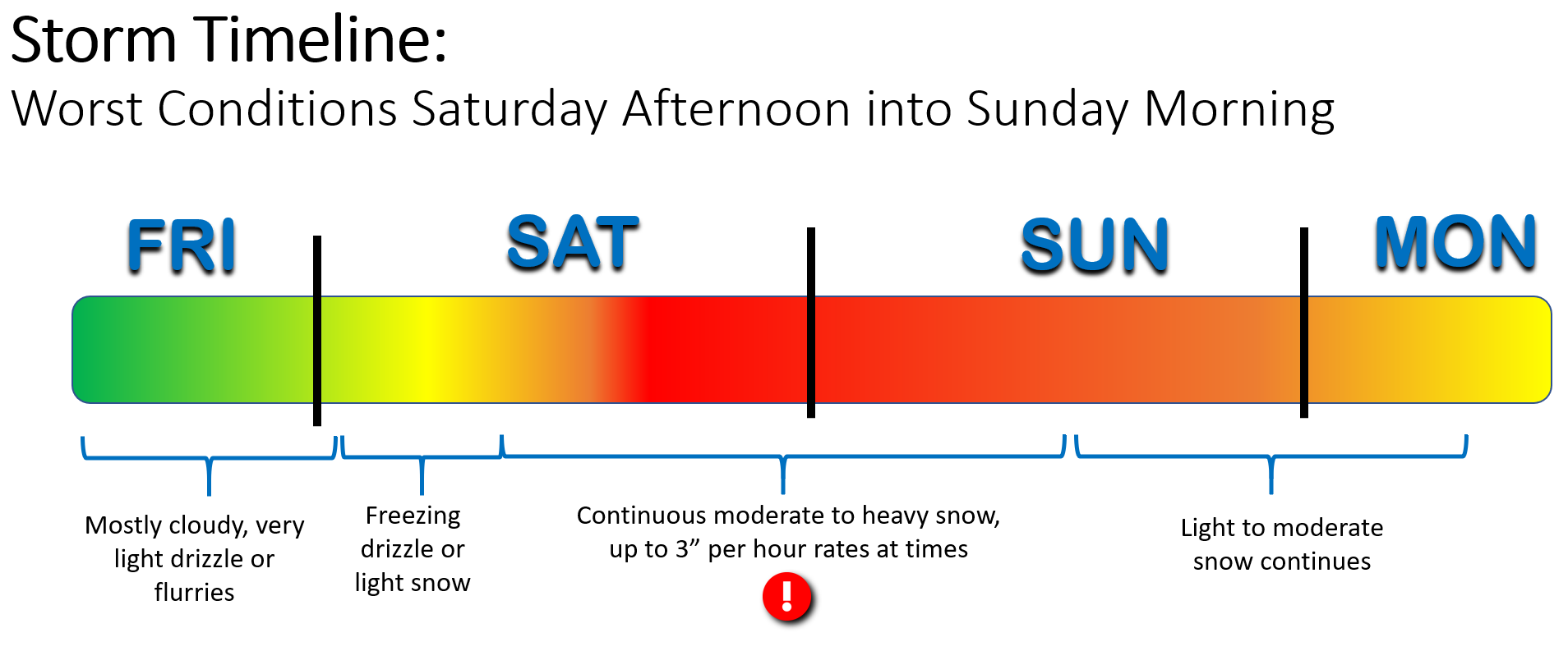
The storm remains on-track!
Due to factors related to the local terrain of northeast Colorado, a majority of our snowstorms tend to begin towards the end of the day. Inevitably, for the comparatively few snow events that commence in the first half of the day, many folks fret over a busted storm if absolute snow-globe conditions don’t exist the moment they wake up, whether that’s 5:00 AM or 11:00 AM.
We’re here this morning to reaffirm to your that our major and borderline-historic winter snowstorm remains ontrack! Though the event hasn’t really deviated much from our initial timeline discussed yesterday, it does seem to be running just slightly behind schedule. This isn’t a big concern, the storm has been slowing down all along. In fact, we half-expected this is the update we’d be passing along today.
The center of the main storm is located in far southwest Utah right now. Convection and thunderstorms have been roaring all morning across southeast Colorado, a sign of the energy and abundance of moisture streaming our way!
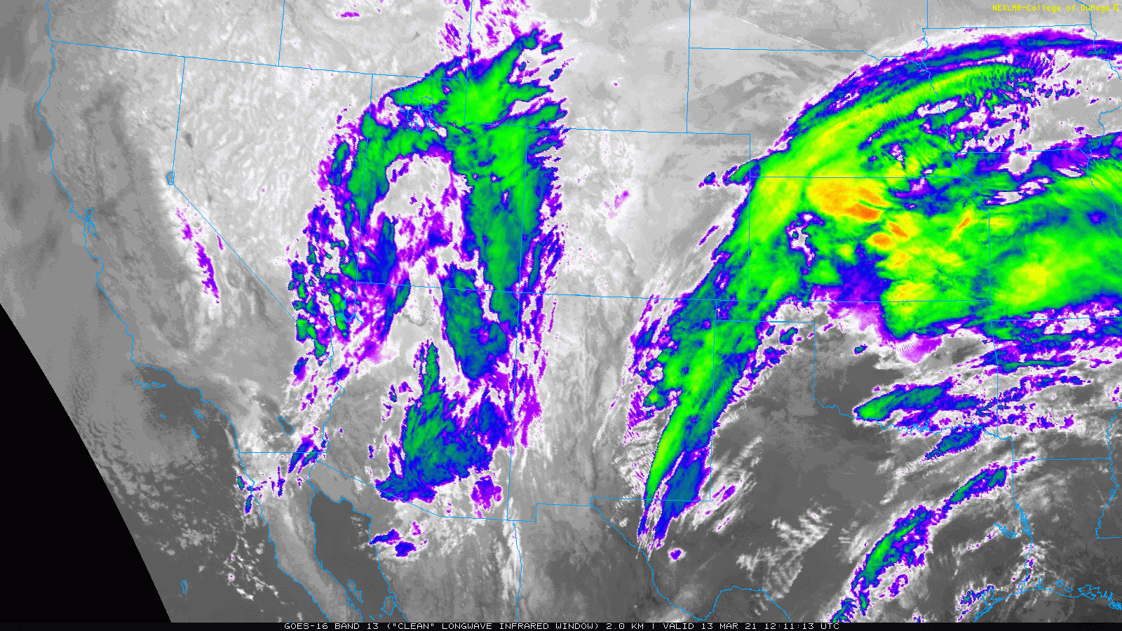
GOES-East infrared satellite animation from Saturday morning
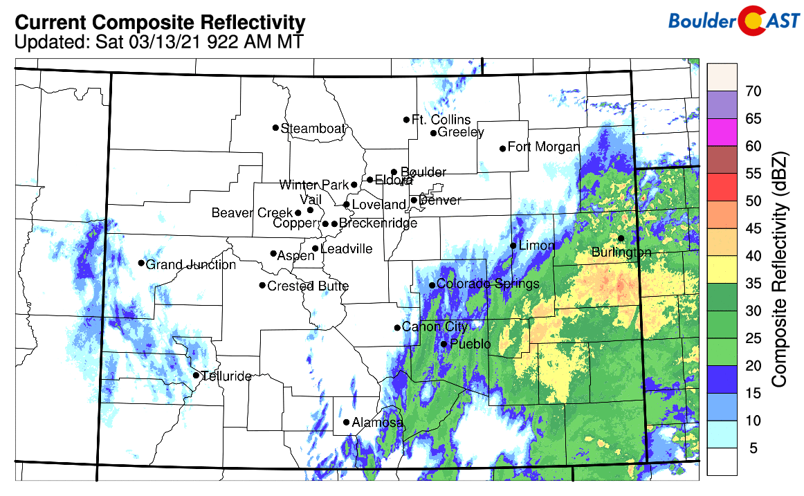
The best lift will be arriving to the Front Range around mid-day with a sharp increase in precipitation coverage. It will be a very wet snow through the afternoon, but it will be snow nonetheless. Colorado Springs is already getting slammed this morning with heavy snowfall. This will be overspreading the Denver and Boulder area in no time. Just have patience…
Additionally, we are going into the event with more confidence today than we had yesterday as models have come into better agreement on amounts in last night’s runs and again this morning. We’re also noting good consistency that the dry slot won’t be a major factor for the Front Range, but will stay largely east and southeast of our area. We’re seeing consistency across the board for a very impactful snow event for the entire Denver Metro area and adjacent Foothills, with at least 2″ of much-needed moisture expected to fall between now and Monday, with up to 4″ in the higher terrain.
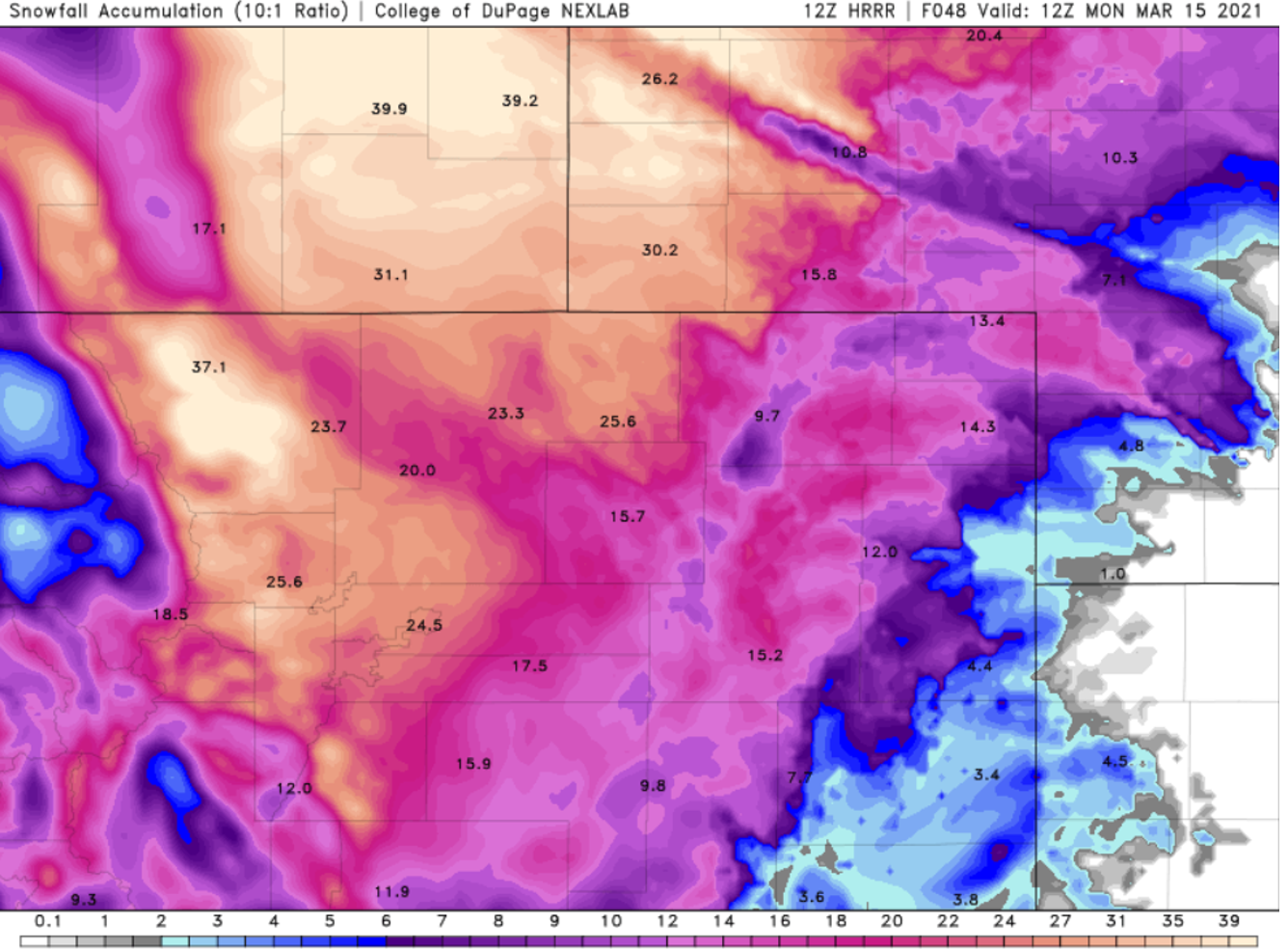
Let’s run through a few of the latest snowfall predictions from the models. There’s been a slight uptick in expected snowfall amounts across the board since yesterday. Note that everything we are showing below is using 10:1 snow to liquid ratios. This may be a tad high for the lower elevations, but it’s close enough to ballpark nonetheless.
Here’s the HRRR snowfall forecast. Widespread totals of 18 to 30″ are indicated across the area.
The high-resolution NAM model is predicting 16 to 25″ for the Metro area, which is one of the lower models right now. It’s important to note that this model is still considerably further north with the storm track than most projections which is negatively impacting snowfall amounts for the Front Range.
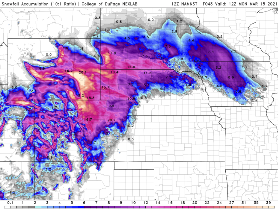
The lower resolution NAM is predicting similar amounts, mainly 15 to 22″ for us.

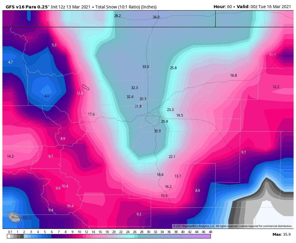
Unlike the current GFS, a.k.a. the rainy model, the next generation GFS model is forecasting actual snowfall for this event, and lot of it! Looks at those totals….25 to 35″ for everyone! This is on the high-end of current model trends, but is not fully out of the question.
Finally, let’s look at a few point forecasts from our NowCAST suite, which is basically a targeted blend of several models. Below depicts the next 36 hours in Boulder. After the initial mix of rain/snow Saturday morning, heavy snow will arrive and continue all the way into Sunday afternoon with a storm total of 21″ by Sunday at 3PM. Keep in mind that light to moderate snow is expected to last for another 6 to 12 hours past this timeline, so additional accumulations would be possible. Throughout the entire event, temperatures will remain right around freezing. There will also be the potential for blustery north winds during the day Sunday, making any travel even more challenging.

The outlook for Denver is essentially the same, but shows possibly some drying or lighter snow working in late Saturday evening and Saturday night with a total of 16″ by Sunday afternoon. Temperatures again here are also right near the freezing mark.

The bottom line: just sit tight. The storm isn’t a bust and remains fully on-track. Things will look at lot different this afternoon than they do this morning. Travel conditions will deteriorate through the afternoon and evening with widespread moderate to heavy snowfall. Travel may become impossible, especially in and near the Foothills. The threat of the heavier snow will last through much of Sunday before winding down Sunday evening and night. As mentioned, we’re actually more confident in the higher-end snowfall totals now than we were just 24 hours ago. In our opinion, a bust now also seems much less likely.
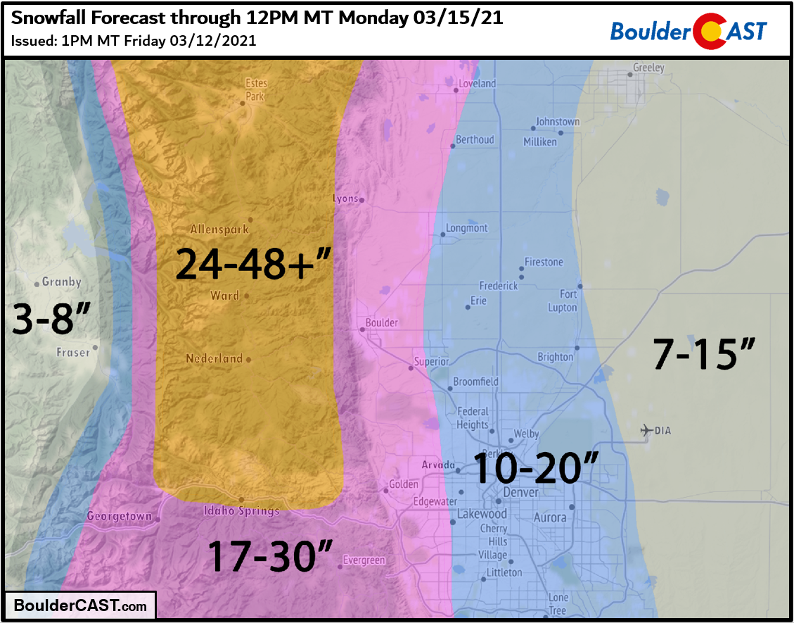
We’re not making any adjustments to our going snowfall forecast at this time:
- Boulder and the far western suburbs of Denver: 17-30 inches
- Denver area: 10 to 20 inches, but lower east
- Foothills above 6000 feet elevation: 2 to 4 feet (locally up to 6 feet in Larimer County)
Overall Forecast Confidence: Somewhat High
We’ve done enough talking about the snow. Let’s all sit back and enjoy it!

REMINDER: This storm needs to break 22.5″ to be a Top 10 contender for Boulder. This is possible, though not a guarantee. Below is a listing of Boulder’s Top 11 snowstorms since 1948.
29.9″ 10/24/1997 –> 10/26/1997
26.0″ 4/7/1959 –> 4/11/1959 (likely was two storms)
26.0″ 12/20/2006 –> 12/21/2006
25.9″ 3/29/1970 –> 3/31/1970
24.0″ 11/20/1979 –> 11/21/1979
23.0″ 5/5/1978 –> 5/6/1978
23.0″ 10/28/2009 –> 10/29/2009
22.9″ 4/2/1957 –> 4/3/1957
22.7″ 2/3/2012 –> 2/4/2012
22.5″ 3/18/2003 –> 3/19/2003
22.5″ 11/25/2019 –> 11/26/2019
NOTE: This historical context only applies back to ~1950 when reliable daily snowfall observations for Boulder became available. Storm totals were derived by summing consecutive days with reported snowfall.
Check back or subscribe to get notified instantly when our forecast updates go live:
We respect your privacy. You can unsubscribe at any time.
Help support BoulderCAST and save 25% with promo code HEAVYSNOW
Help support our team of Front Range weather bloggers by joining BoulderCAST Premium. We talk Boulder and Denver weather every single day. Sign up now to get access to our daily forecast discussions each morning, complete six-day skiing and hiking forecasts powered by machine learning, first-class access to all our Colorado-centric high-resolution weather graphics, bonus storm updates and much more! Or not, we just appreciate your readership!

.
Spread the word, share the BoulderCAST forecast!
.


You must be logged in to post a comment.