We provide a quick update on the situation this morning as wet snow continues to fall across the Front Range. While the storm has been underwhelming to some, we’ve still got nearly 24 hours of snowstorm left and a clear pathway to reach the lower bounds of our original snowfall prediction. Let’s run through the latest.
Help support our team of Front Range weather bloggers by joining BoulderCAST Premium. We talk Boulder and Denver weather every single day. Sign up now to get access to our daily forecast discussions each morning, complete six-day skiing and hiking forecasts powered by machine learning, first-class access to all our Colorado-centric high-resolution weather graphics, bonus storm updates and much more! Or not, we just appreciate your readership!

Receive BoulderCAST updates as soon as they go live…
.
An extra slow-mover
The winter storm thus far has been a little underwhelming with the heaviest snow largely remaining north of Boulder and Denver. Places like Fort Collins and Loveland have picked more than a foot of snow already and we’ve even seen reports of thundersnow along the Wyoming border and in Cheyenne!
Here’s a look at Boulder County snow reports as of 7AM Sunday… 8-10″ across the Plains with 10-16″ in the Foothills.
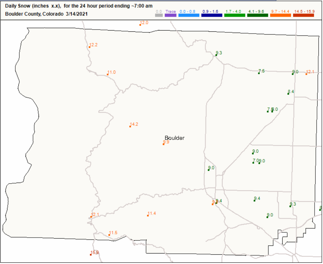
Boulder County snow totals so far through 7AM Sunday
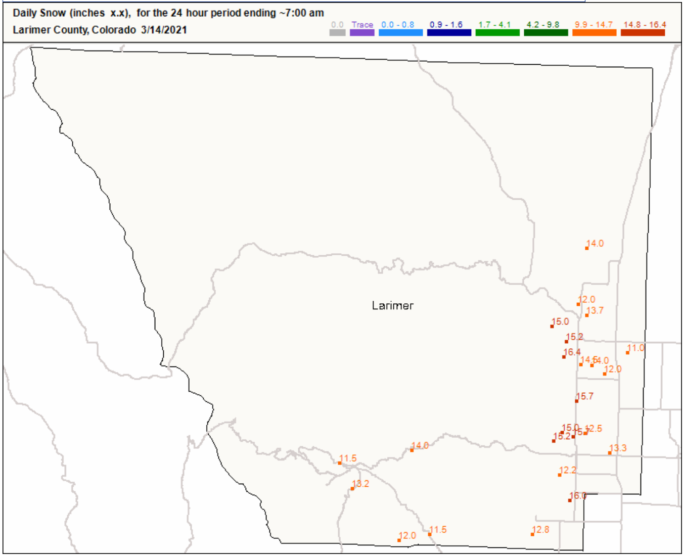
In Larimer County, everyone has a foot already!
This northward bias is due to the very slow-movement and positioning of the storm thus far with generally southeasterly flow coming into the Front Range. This direction greatly favors Larimer County and can cause a downsloping effect in the Denver area coming down from the Palmer Divide. There was also a very long and narrow dry slot wrapping into the system overnight, which you guessed it, lined up right over downtown Denver and Boulder. We certainty saw this overnight with decreased snow intensities in these areas.
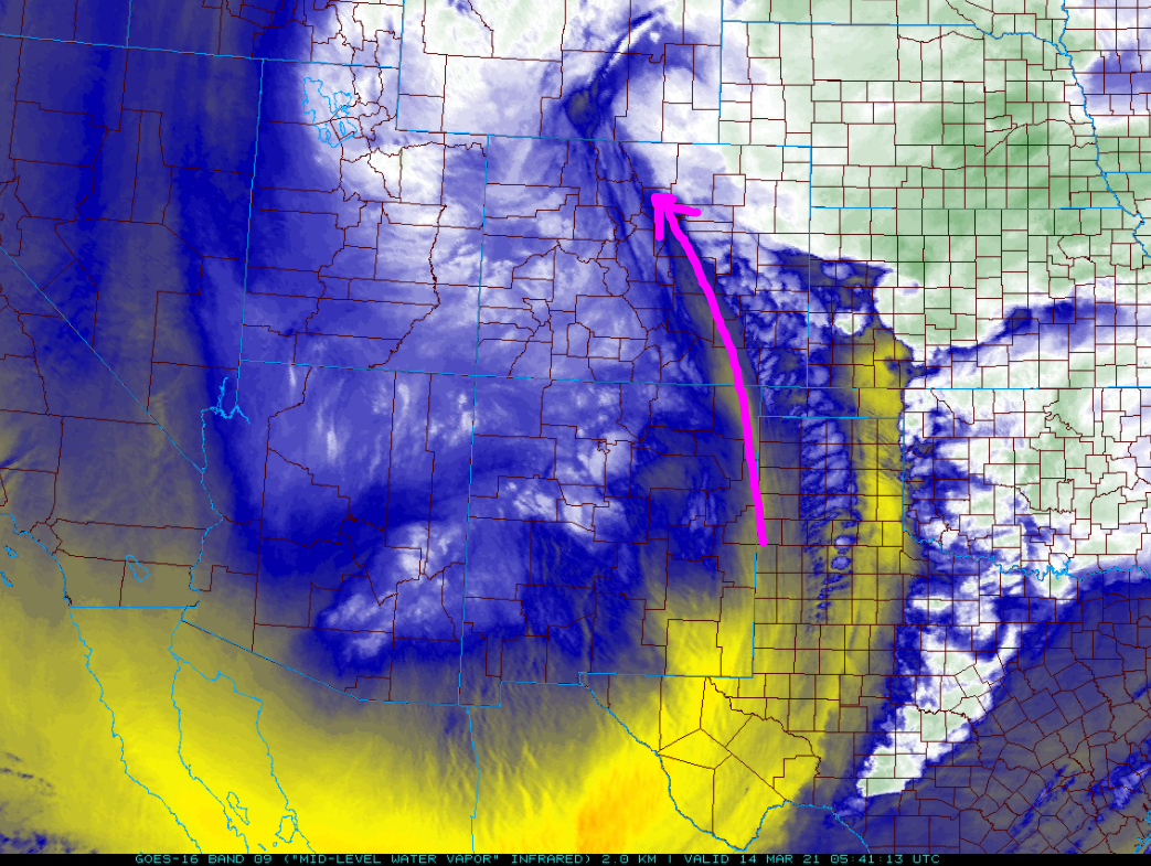
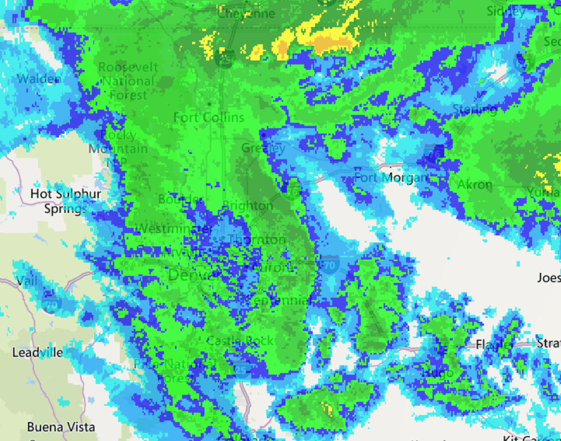
As of early Sunday, the heaviest snow has already begun to shift southward into the immediate Metro area as our storm system drifts eastward and flow pivots to a more favorable easterly upslope direction. Here’s a look at regional radar as of 7:00 AM. The upslope flow is clear, with lots of deep moisture banking up against the terrain west of Interstate 25!
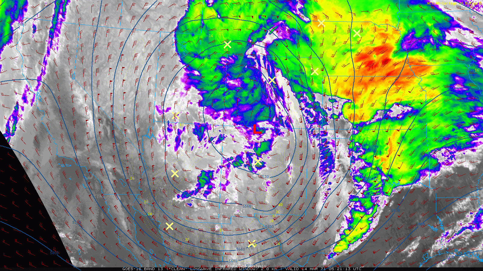
GOES-East infrared satellite imagery from this morning shows the mid-level low pressure drifting eastward along the Colorado-New Mexico border. Notice how the wind barbs across the Front Range have backed from southeasterly to easterly. This is the intensification of upslope we were waiting for and the models were predicting all along. This position is perfect for us! Since the storm is moving so utterly slow, we should be able to cash in on this moderate to heavy snowfall much of the day Sunday as a result.
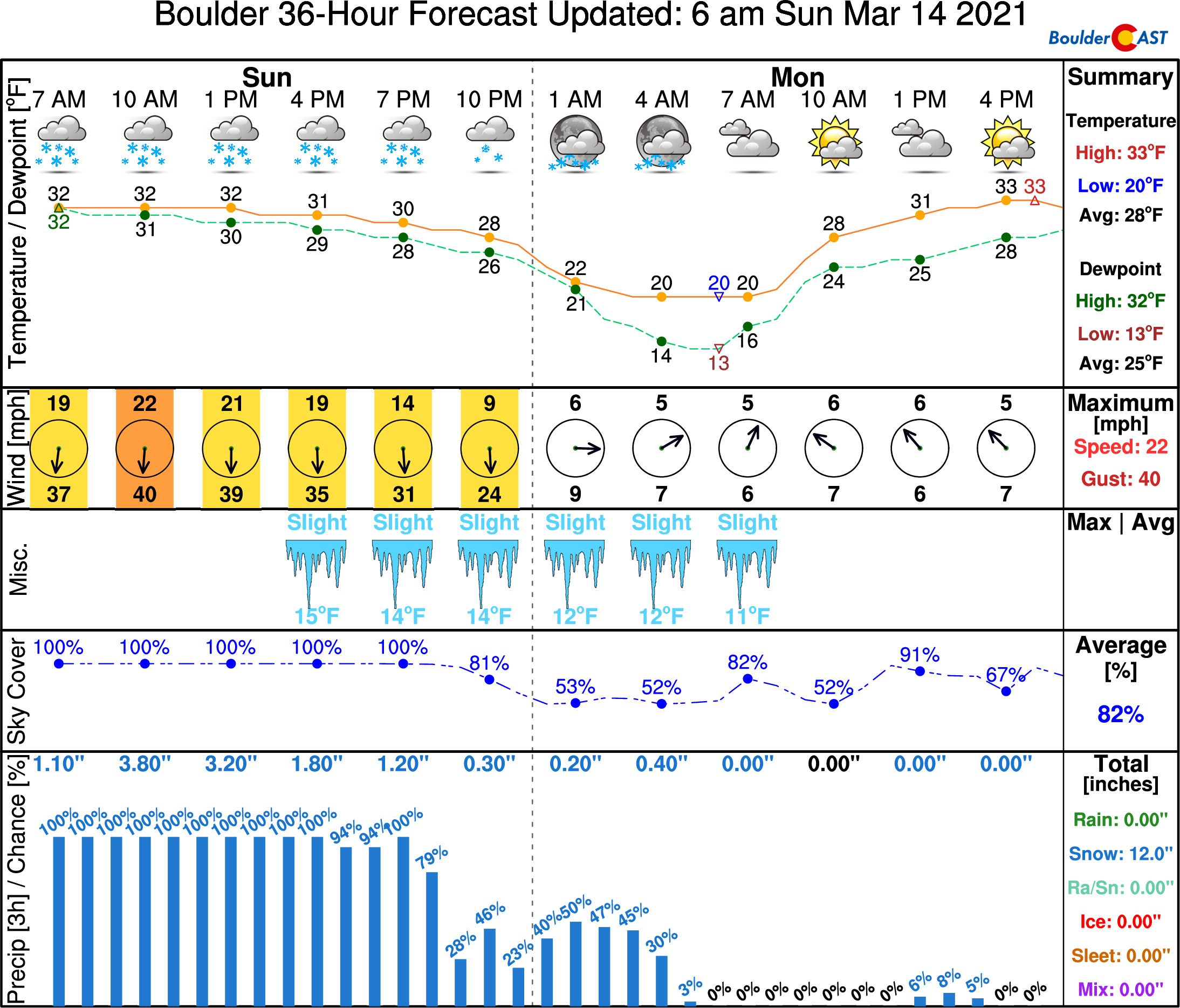
Latest high-resolution model data indicates the heavier snow across the Front Range will remain through the entire morning and into the early afternoon before starting to lighten up into the evening. The storm is moving even slower than original expectations, so it’s a safe bet to assume at least light snow will linger well into Sunday night if not early Monday morning.

Travel conditions will remain dicey today with widespread moderate to heavy snowfall and an uptick in the winds expected. Roadways across the lower elevations should clear out a little though with the high March sun-angle piercing through even the thickest of snow clouds this afternoon. Travel in the Foothills and Mountains east of the Divide is not advised.
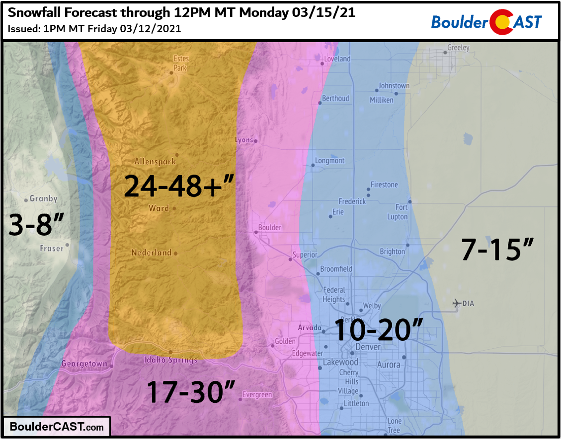
The bottom line: the storm is not over, despite what the naysayers would have you believe. We’ve got nearly 24 hours of snow to go, including a prolonged period early Sunday where snowfall rates of 1 to 2″ per hour will be widespread! While this storm likely won’t be something you tell your grandkids about, it still has the potential to produce 10+” in Denver and 17+” in Boulder, right within the lower bounds of our original forecast. Go figure…
REMINDER: This storm needs to break 22.5″ to be a Top 10 contender for Boulder. This is possible, though no longer that likely. Below is a listing of Boulder’s Top 11 snowstorms since 1948.
29.9″ 10/24/1997 –> 10/26/1997
26.0″ 4/7/1959 –> 4/11/1959 (likely was two storms)
26.0″ 12/20/2006 –> 12/21/2006
25.9″ 3/29/1970 –> 3/31/1970
24.0″ 11/20/1979 –> 11/21/1979
23.0″ 5/5/1978 –> 5/6/1978
23.0″ 10/28/2009 –> 10/29/2009
22.9″ 4/2/1957 –> 4/3/1957
22.7″ 2/3/2012 –> 2/4/2012
22.5″ 3/18/2003 –> 3/19/2003
22.5″ 11/25/2019 –> 11/26/2019
NOTE: This historical context only applies back to ~1950 when reliable daily snowfall observations for Boulder became available. Storm totals were derived by summing consecutive days with reported snowfall.
Check back or subscribe to get notified instantly when our forecast updates go live:
We respect your privacy. You can unsubscribe at any time.
Help support BoulderCAST and save 25% with promo code HEAVYSNOW
Help support our team of Front Range weather bloggers by joining BoulderCAST Premium. We talk Boulder and Denver weather every single day. Sign up now to get access to our daily forecast discussions each morning, complete six-day skiing and hiking forecasts powered by machine learning, first-class access to all our Colorado-centric high-resolution weather graphics, bonus storm updates and much more! Or not, we just appreciate your readership!

.
Spread the word, share the BoulderCAST forecast!
.


You must be logged in to post a comment.