Sure…it has been fairly smoky already this week across our area, but it’s about to get a whole lot worse! An extremely smoke-laden airmass is poised to invade the entire state of Colorado late Friday night. The cause? An upstream low pressure system has been hard at work gathering up literally ALL the smoke from massive wildfires burning in California, the Pacific Northwest and southern British Columbia…and guess what? That low pressure system is headed our way!
At a glance:
- A low pressure system has collected much of the smoke from large, upstream wildfires burning across six states and parts of Canada
- Extremely smoky air will arrive to Denver after midnight Friday night and stick around into Saturday evening
- The most smoke and worst air quality of 2021 are expected on Saturday
- Temperatures remain in the 90’s with intermittent thick smoke expected through the weekend and much of next week
Help support our team of Front Range weather bloggers by joining BoulderCAST Premium. We talk Boulder and Denver weather every single day. Sign up now to get access to our daily forecast discussions each morning, complete six-day skiing and hiking forecasts powered by machine learning, first-class access to all our Colorado-centric high-resolution weather graphics, bonus storm updates and much more! Or not, we just appreciate your readership!

T
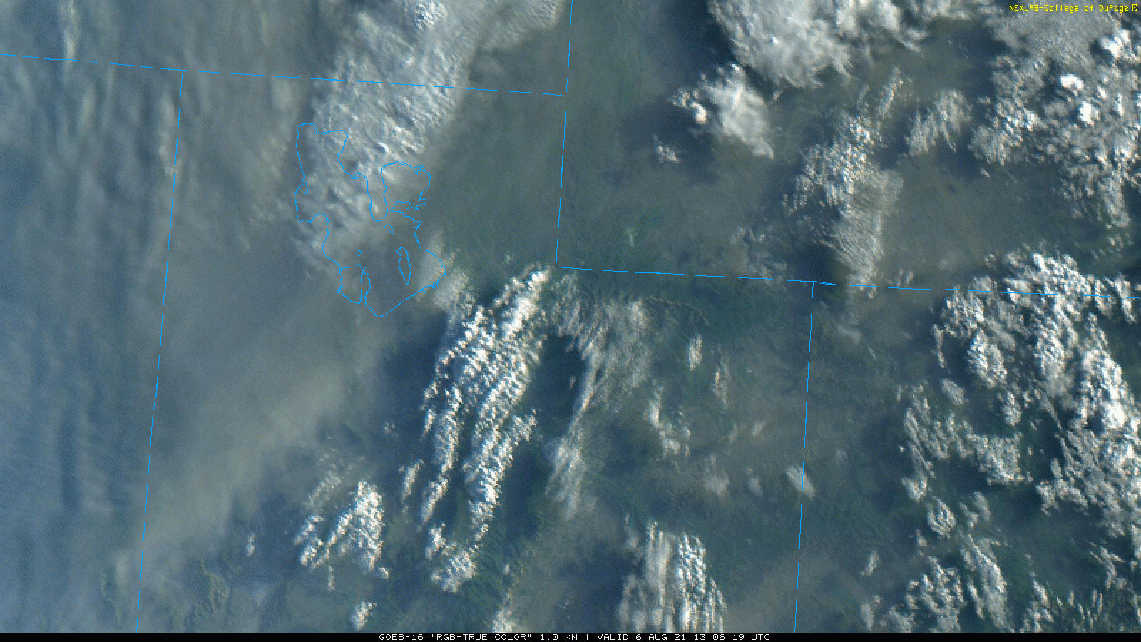
he visible satellite animation below from Friday morning shows just how thick the smoke associated with this low pressure is. It looks like a small, smoke-riddled hurricane is spinning over Idaho. Furthermore, just think about how poor the air quality in Denver is right now (PM2.5 has been above 100 for a few days). From this satellite animation, the Front Range appears almost pristine. Just imagine what that upstream airmass will bring to the table. You ain’t seen nothing yet!
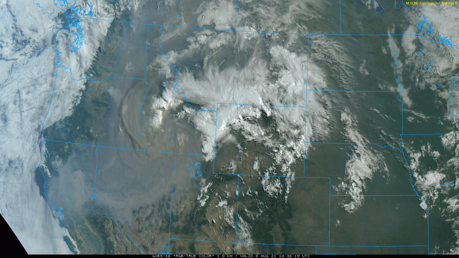
GOES-East visible satellite animation from Friday morning
Here’s a closer look at one of the main contributors of smoke across the entire West right now, the Dixie Fire in northern California. This massive blaze started about three weeks ago when a falling tree took down a powerline. As of today, it has burned more than 432,000 acres. To put this into perspective, this is more acreage than the two largest fires in Colorado state history combined….those of course being the East Troublesome and Cameron Peak wildfires from last year.
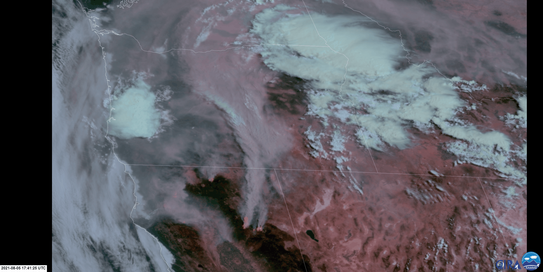
The view from GOES-West of the Dixie Fire burning Thursday morning (8/5/21)
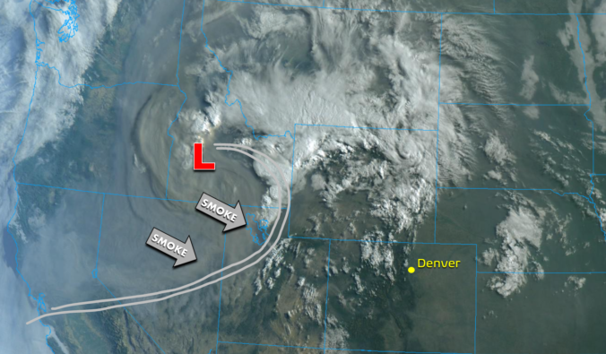
The track of the low pressure system over the next 24 hours will take it east-southeastward and across Wyoming.
With this track, the plume of smokiest air will push directly across the Denver Metro area. This is the latest regional total smoke forecast.
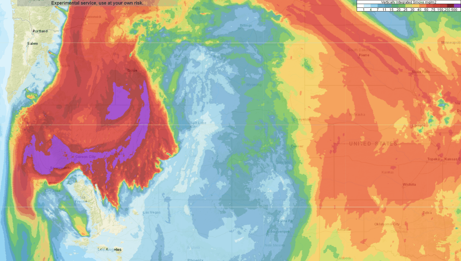
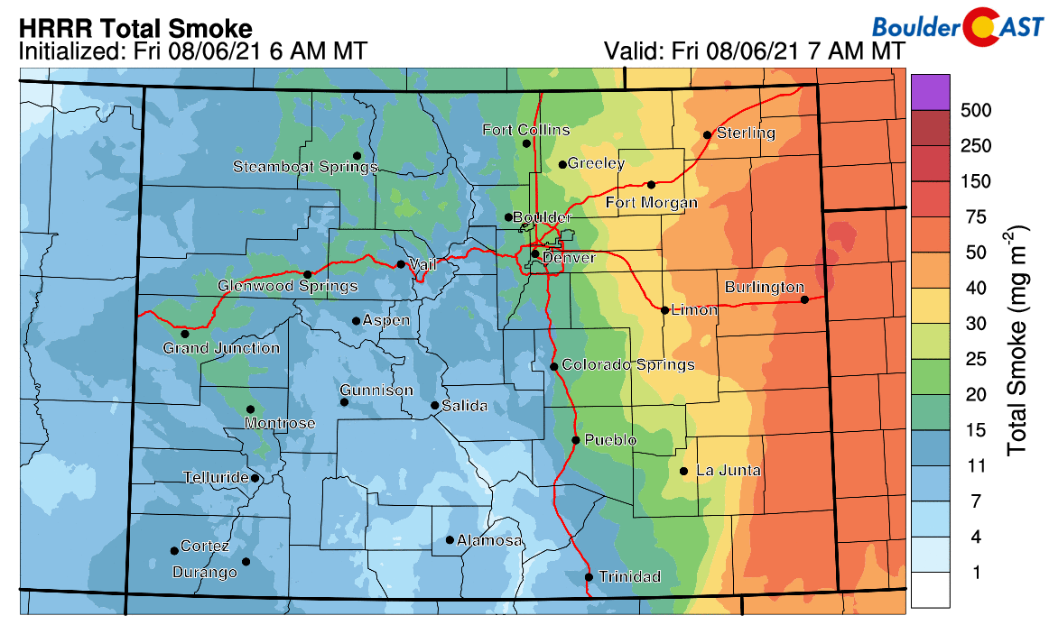
And here’s a closer look at the total smoke forecast for just our beautiful state. What an impressive surge of smoke! That’s definitely what we would call a “smoke front”.
The forecasts we’ve shown so far are for total smoke, which is the sum of all smoke particles through the entire depth of the atmosphere. This parameter doesn’t necessarily tell us anything about how much smoke will be at ground-level affecting our air quality. Typically, the hot air outgassed on-site by wildfires causes the smoke to rise up and soar into the middle and upper atmosphere before it can spread out too far from the source. This means that downstream areas will often have a lot of elevated smoke which muddies up the sky, but not necessarily much surface smoke to tank ground-level air quality. This time, though, the atmospheric setup has been supportive of moderate subsidence for more than a day now within the smoky airmass. Thus, there is a lot of smoke at the surface as well which will be pouring into the Denver Metro area in short order. Shown below is the surface smoke forecast for Colorado. This represents the smoke you will actually be breathing!
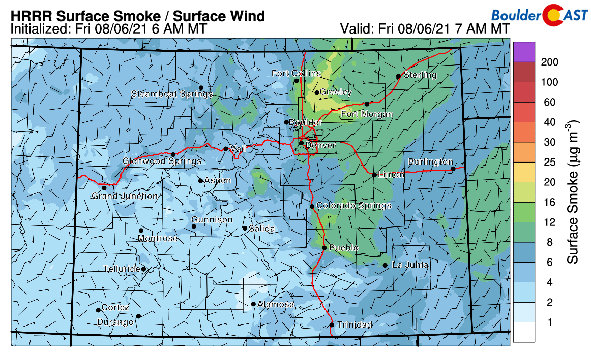
We will mention that the timing and magnitude of this surface smoke forecast are less certain due to the interaction the smoky air will have with the beefy terrain moving across Colorado, but for the most part, the thick smoke should spill into the Boulder and Denver areas between midnight and 6:00AM early Saturday morning. The surge of smoke may be accompanied by gusty northwest winds up to 25 MPH. Too bad this will all be happening during the overnight period. The passage of this smoke front would have been quite the sight to behold!
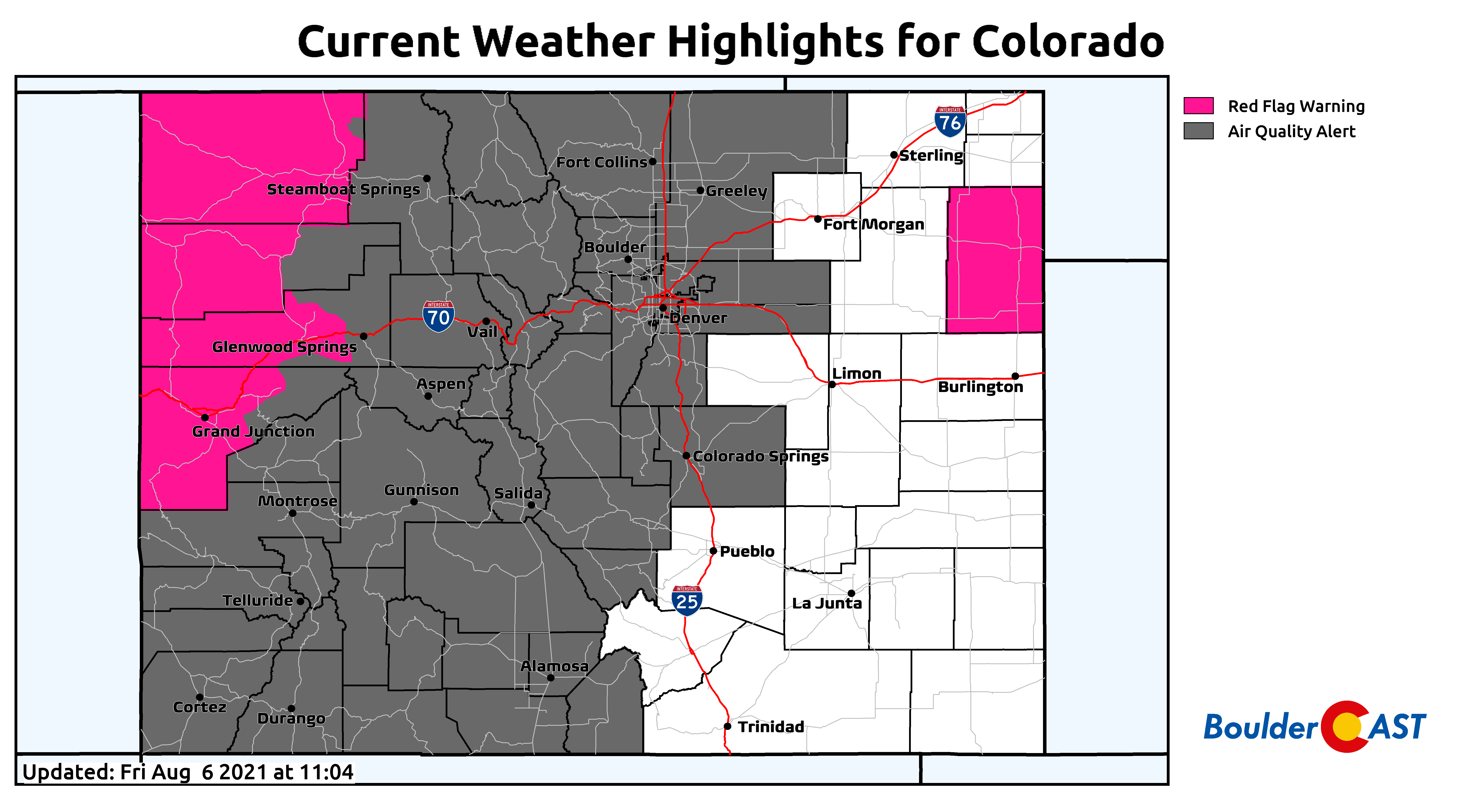
At the time of writing Friday morning, nearly two-thirds of Colorado are under an Air Quality Alert in preparation for the incoming “Smokeggedon”. This is the most widespread coverage of this state-issued advisory so far this summer and the 32nd consecutive day for Denver and Boulder!
Finally, let’s just take a look at what’s happening upstream, as it may be an indicator for what things will be like in Denver tonight and tomorrow. That motherlode of smoke has just arrived to Salt Lake City within the last few hours. You can see this in the visible satellite animation below of northern Utah.
GOES-East visible satellite animation near Salt Lake City Friday morning
PurpleAir PM2.5 air quality observations captured the smoke’s arrival, and the change was nothing short of dramatic. Salt Lake City’s air quality index was under 50 (Good) around 8:30AM Friday morning. By 11:00AM, the smoke moved in an the index soared above 300 (Very Unhealthy)!
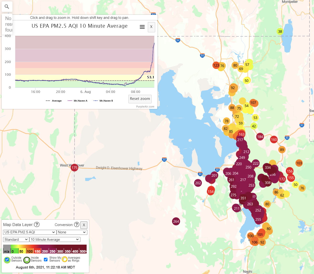
While we do expect a drastic uptick in smoke tonight for the Front Range, it shouldn’t be quite as extreme as what unfolded on the shores of the Great Salt Lake. That area is notorious for poor air quality due to the way the surrounding terrain contains the air. Between now and tonight, the smoke headed our way will disperse a little bit more. However, we fully expect Denver’s PM2.5 Air Quality Index values to soar above 150 (Unhealthy) on Saturday, perhaps even above 200! You WILL be able to smell this smoke and don’t be surprised to see a light accumulation of ash!
The thickest smoke is projected to stick around into Saturday night before some slight improvements take shape on Sunday. Another wave of thick smoke could return on Monday when our next weather system is scheduled to arrive from the northwest. In addition to the smoke, but trumped in importance right now, this weekend will also be warm and dry across the Front Range and most of Colorado.
As gross as the air is already, get your outdoor activities done A.S.A.P…..you’re not going to want to do them this weekend! Enjoy…
Stay up to date with Colorado weather and get notified of our latest forecasts and storm updates:
We respect your privacy. You can unsubscribe at any time.
We discuss Boulder and Denver weather every single day on BoulderCAST Premium. Sign up today to get access to our daily forecast discussions every morning, complete six-day skiing and hiking forecasts powered by machine learning, access to all our Front Range specific weather models, additional storm updates and much more!
.


You must be logged in to post a comment.