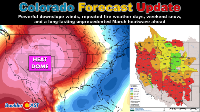
After Tuesday’s surprise temperature split and a sneaky round of overnight rain‑to‑snow, the Front Range is gearing up for a volatile stretch ahead defined by powerful downslope winds, repeated fire weather days, and a weekend cold front with a few snowflakes behind it. And beyond that? An unbelievably intense mid‑March heat wave that will rewrite the record books and kick off snowmelt across much of the West next week. Let’s get into the details.
What You Need to Know
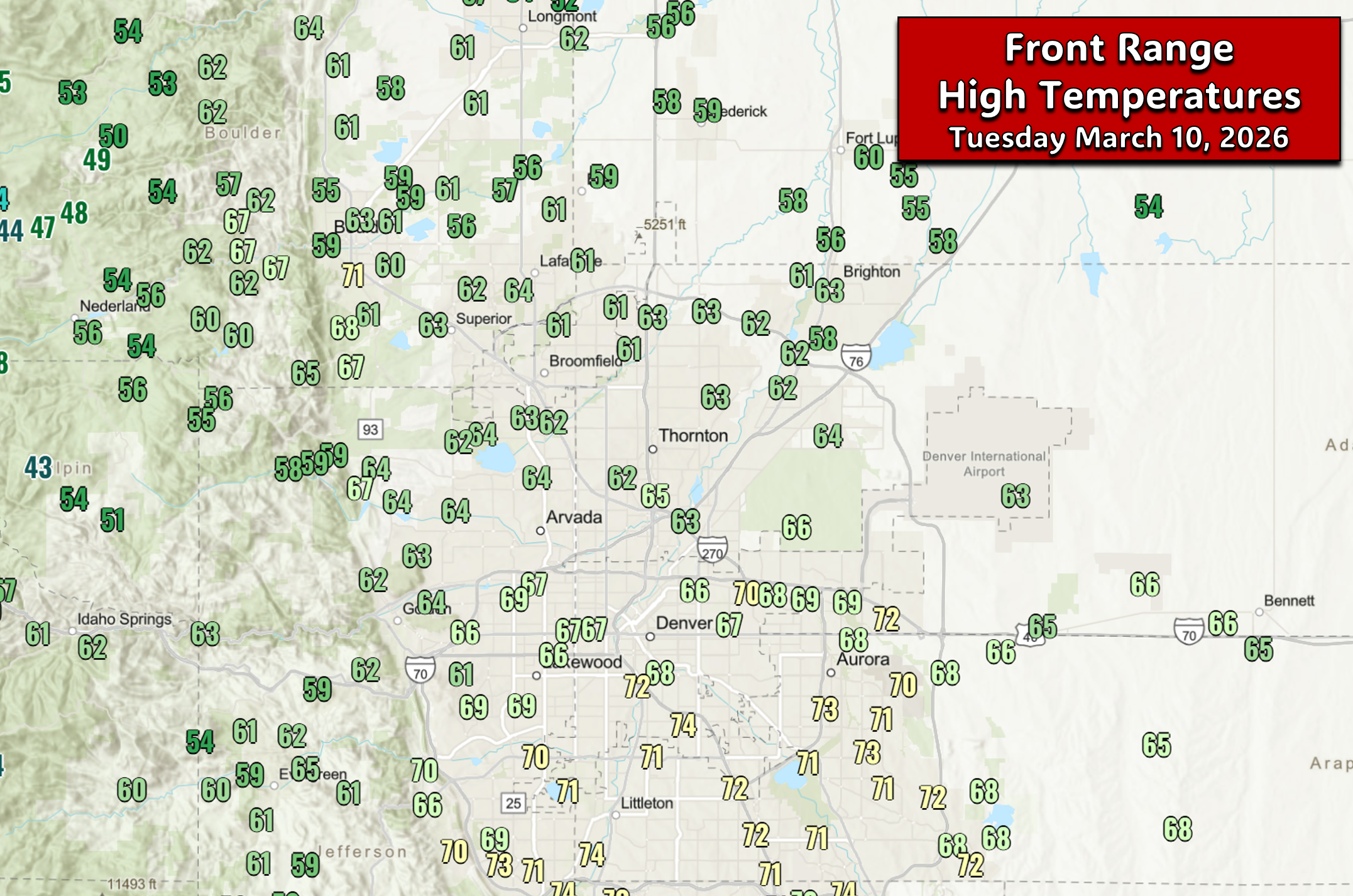
- 🌡️ Tuesday’s temps were split sharply as a stubborn frontal boundary kept the north in the 50s/60s while the south surged past 70°.
- 🌧️ Evening rain/snow bands materialized, delivering a brief burst of wet snow with a coating in town and 1–3″ in the Foothills.
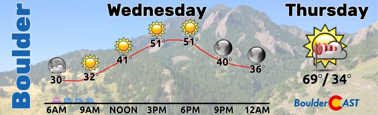
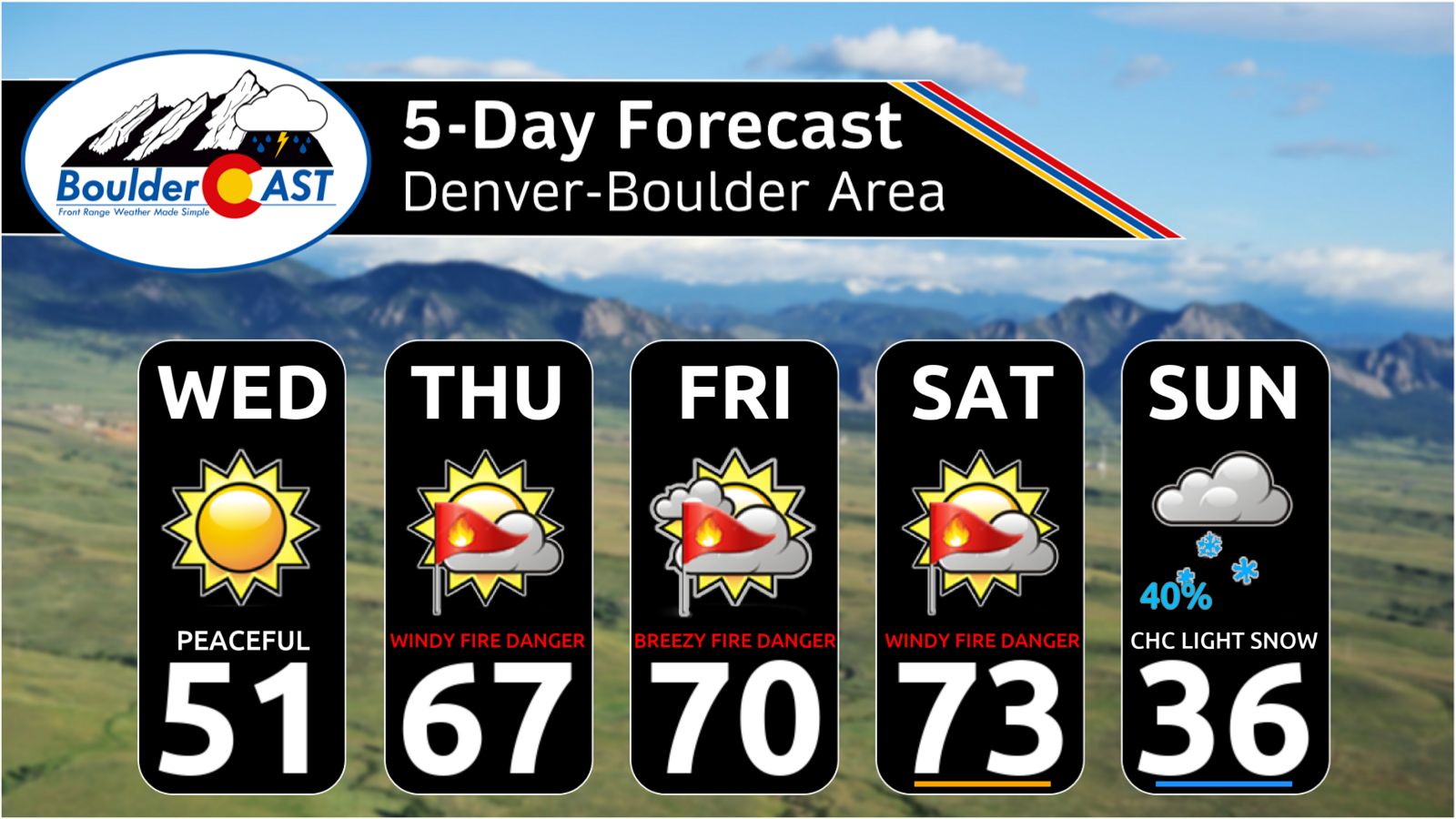
- ☀️ Wednesday is the calm intermission — sunny, cooler, and generally light winds with highs in the lower 50s.
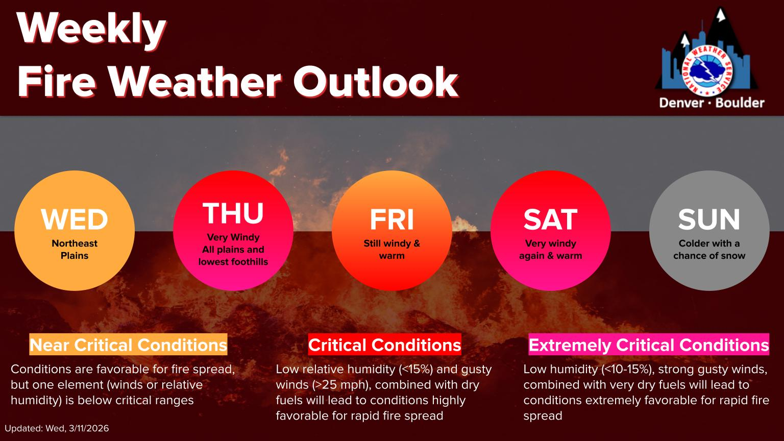
- 🌬️ A major downslope windstorm ignites Wednesday night, with classic mountain wave dynamics driving 70–90 MPH gusts above 6,500–7,000 ft.
- ⚠️ Potential for damaging winds in Boulder Thursday, though this remains uncertain; everyone still sees 25–40 MPH gusts and critical fire danger.
- 🔥 Friday stays warm with near‑critical fire danger, with highs in the low 70s and another round of breezy, dry conditions.
- 💨 Saturday brings a stronger front, a daytime wave + nighttime bora wind event, widespread strong gusts, and high to extreme fire danger as highs push into the mid‑70s.
- ❄️ Sunday will offer a chance of light snow, but current data suggests 1″ or less. Either way, temperatures will be sharply colder with highs in the 30s to lower 40s.
- 🌡️ A powerful ridge builds in next week setting up a multi‑day, mid‑March heatwave with a long stretch of 70° and 80° days leading to an early onset of Mountain snowmelt.

Go Premium, get all the perks.
Daily Forecast Updates
Get our daily forecast discussion every morning delivered to your inbox.
All Our Model Data
Access to all our Colorado-centric high-resolution weather model graphics. Seriously — every one!
Ski & Hiking Forecasts
6-day forecasts for all the Colorado ski resorts, plus more than 120 hiking trails, including every 14er.
Smoke Forecasts
Wildfire smoke concentration predictions up to 72 hours into the future.
Exclusive Content
Weekend outlooks every Thursday, bonus storm updates, historical data and much more!
No Advertisements
Enjoy ad-free viewing on the entire site.
Tuesday’s forecast woes
Yesterday’s forecast took a left turn on us, thanks to a stubborn low‑level frontal boundary that refused to behave. Instead of the uniform warmth we expected, temperatures split dramatically across the Metro. The northern tier stalled out in the mid‑50s to low‑60s, while the southern suburbs surged past 70°. Everyone was still above normal for early March, but the sharp gradient separated t-shirt weather versus light jacket weather.
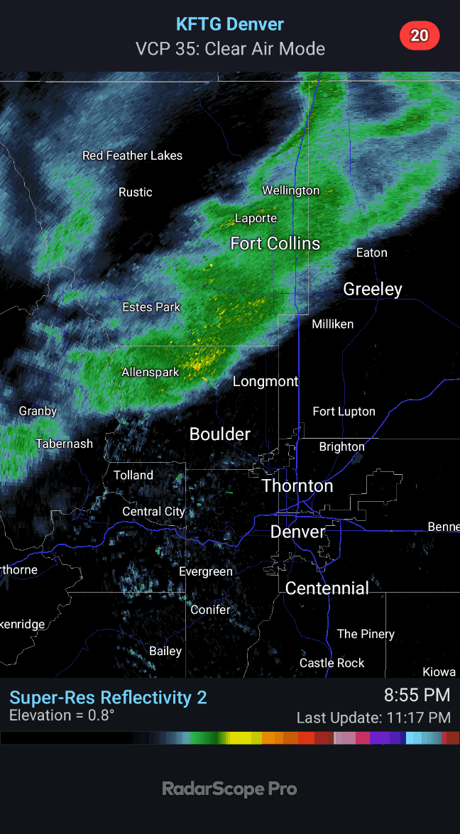
By late afternoon, the atmosphere threw another curveball. Short‑range guidance began locking onto the idea of quick-hitting rain/snow bands developing Tuesday evening — the kind of mesoscale features that models often miss until the last minute.
The bands materialized right on cue around 10PM last night, delivering a brief burst of rain flipping to wet snow.
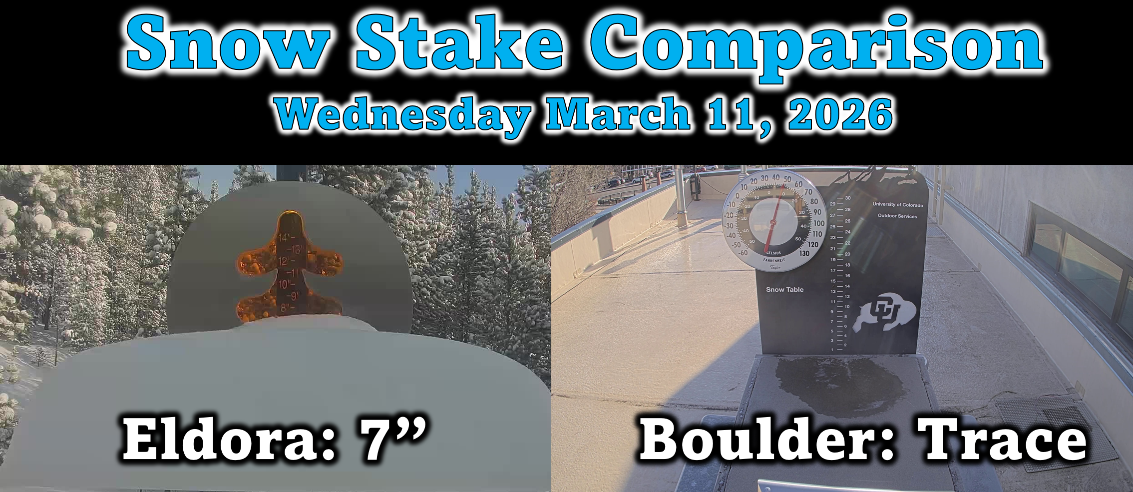
Most lower elevations only managed a coating at best, but the Foothills picked up a solid inch or three. The big winner, though, was Eldora with 7 inches of fresh snow on the table this morning!
Wednesday: A brief calm
Wednesday is our breather, but only a small one. Behind last night’s snow‑band‑producing cold front, temperatures will only top out in the lower 50s for our Wednesday. Sunshine will be abundant, and winds relatively tame aside from a few afternoon westerly breezes. Enjoy it — this is the calmest day we’ll see for quite a while.
Windstorms & Fire Danger Ahead
After midnight Wednesday night, northern Colorado steps back into the boxing ring. A strong, long‑duration downslope windstorm will ignite along the Foothills above roughly 6,500–7,000 feet. This is a classic mountain‑wave setup: a stable layer aloft, strong cross‑barrier flow, and a jet streak nearby. These ingredients will lead to 24+ straight hours of howling winds through Thursday night with gusts up to 90 MPH likely in the higher terrain.
As always, the million‑dollar question is how much of those winds mix down into Boulder and the western Denver suburbs? The signal remains murky at this time. There is a window Thursday afternoon/evening where damaging gusts could reach into parts of Boulder, but the bulk of this event still appears Foothills‑focused. That said, these windstorm patterns can shift abruptly in the final hours, so we need to be very cautious as we get closer to the event.
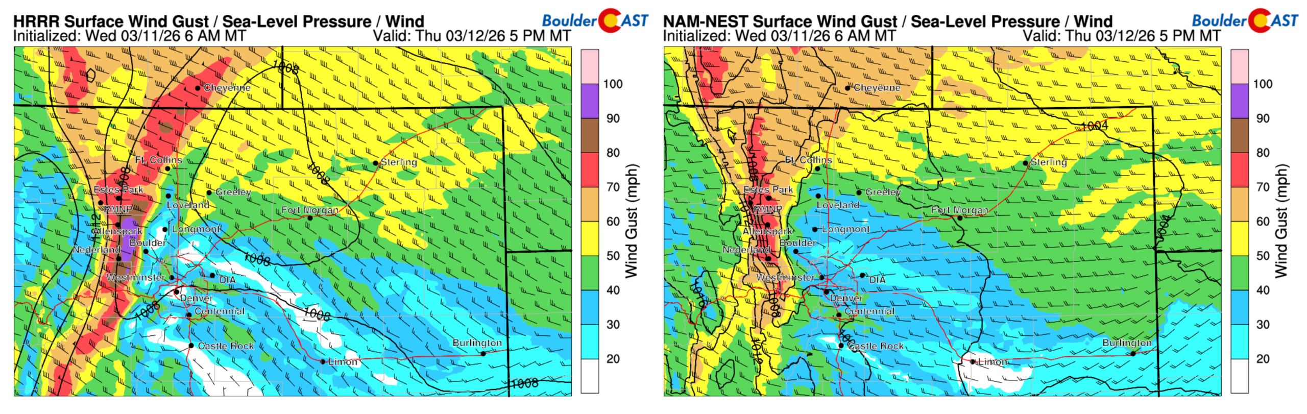
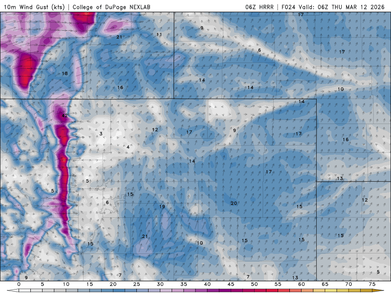
Comparison of forecast 10-meter wind gusts at 5PM on Thursday from two short-range models.
The latest HRRR run hints at ~70 MPH gusts clipping western Boulder and Highway 93 sometime Thursday afternoon into early evening.
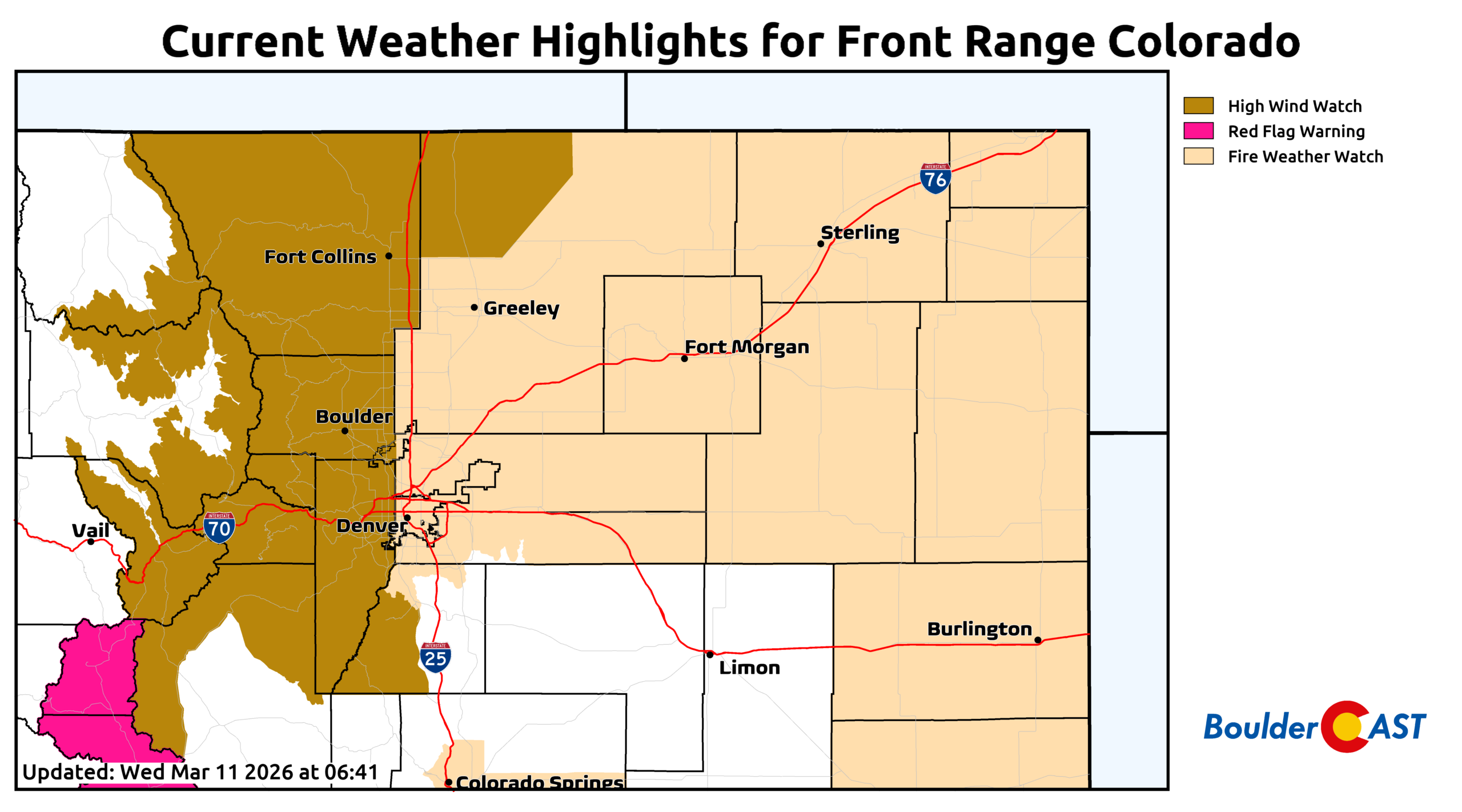
Even if the strongest winds stay higher up, everyone will feel some wind on Thursday as fingers of strong winds spread eastward and additional, weaker mountain waves crash downstream. Expect widespread gusts of 25 to 45 MPH alongside critical fire danger — potentially extreme if the high‑end winds do end up cascading further downslope. Temperatures will surge into the upper 60s and humidity will crater below 15%. As of writing Wednesday morning, a High Wind Watch covers the Mountains, Foothills, and western suburbs (including Boulder), paired with a Fire Weather Watch. Tomorrow will be warm, windy, and high‑risk across the board.
Friday offers little relief. Another breezy, near‑critical fire weather day is on tap, with highs climbing into the low 70s.
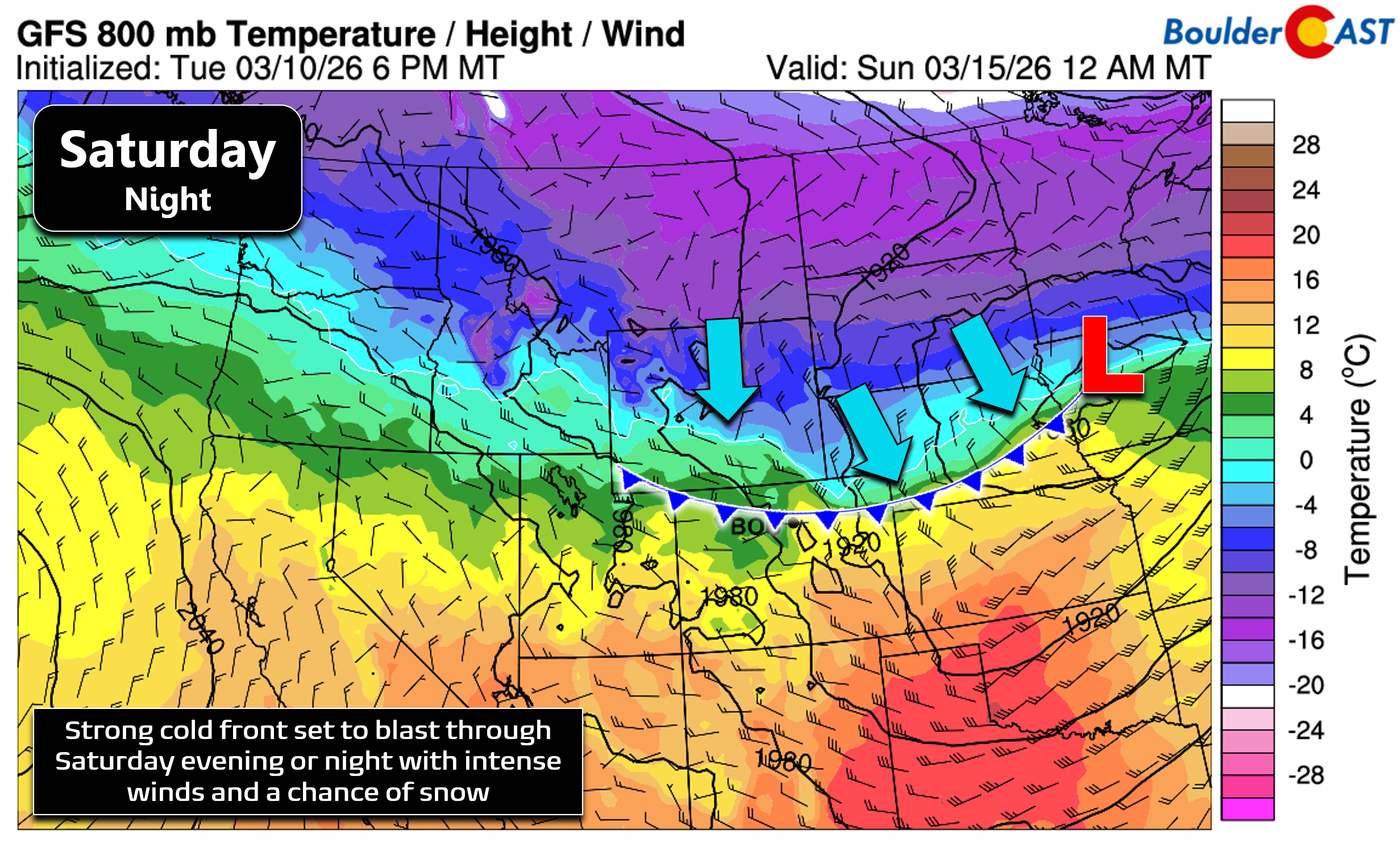
By Saturday, the atmosphere reloads yet again. Winds strengthen ahead of a stronger cold front, with the potential for widespread strong winds across the entire Denver Metro and Foothills. We may see a brief daytime mountain wave event followed by a post‑frontal bora wind Saturday evening and night. Highs will push into the mid‑70s, and fire danger will once again be critical to extreme. With weekend crowds flocking to the Open Space under deceptively “beautiful” weather, the risk of a human‑caused ignition rises sharply. One spark is all it takes — we must remain vigilant and aware of the potential for developing fires in the wildland-urban interface.
Colder with snowflakes possible Sunday
The weekend cold front is currently timed for Saturday evening or night, and global models consistently show a robust wind signature behind it — potentially widespread 50+ MPH gusts across northeast Colorado.
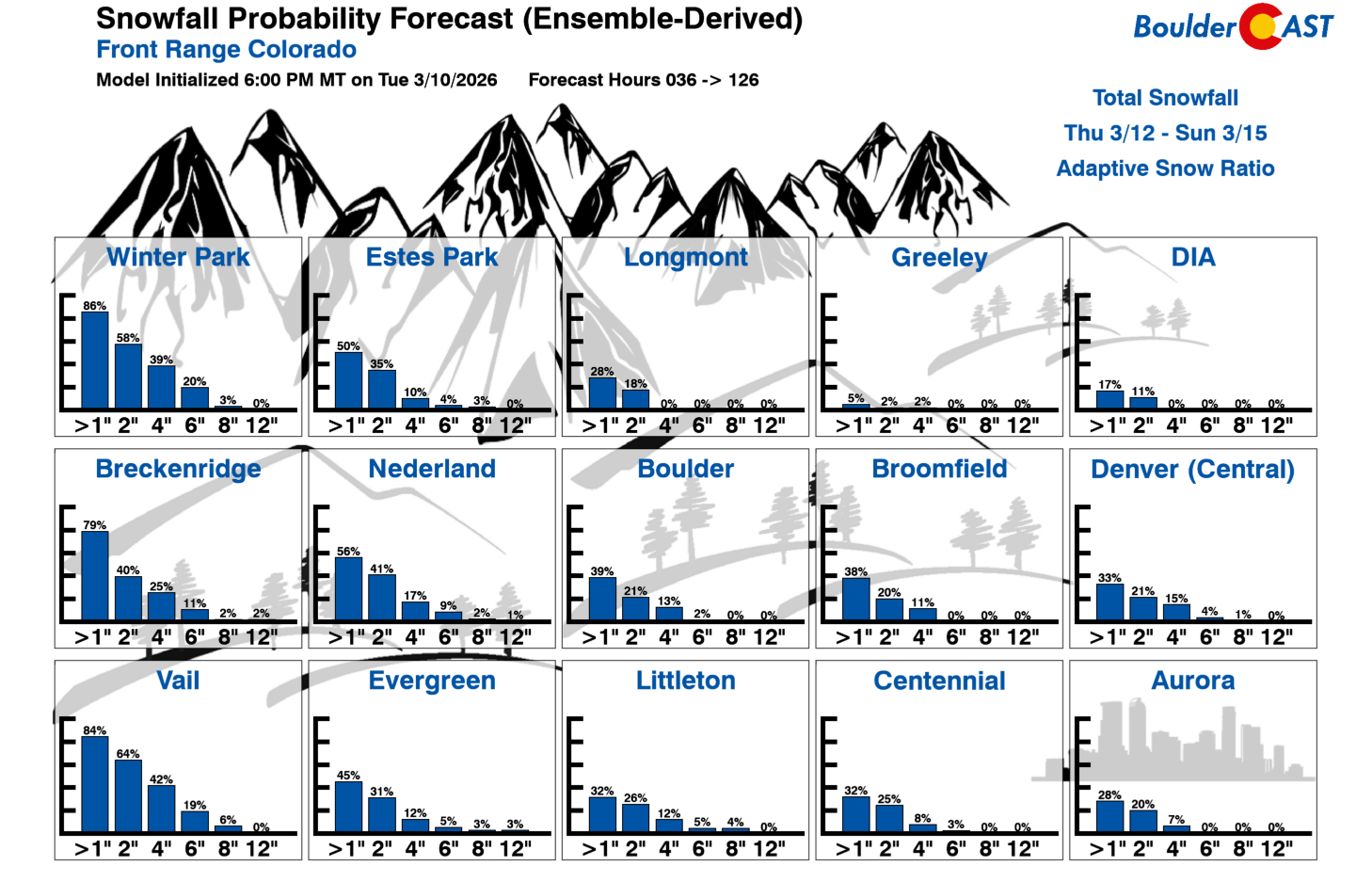
There also appears to be enough post‑frontal lift, upslope, and moisture to squeeze out some light snow on Sunday. Less than an inch is the most likely outcome, though about 20% of GFS ensemble members support up to a couple inches.
Exceptional, prolonged Western heatwave next week
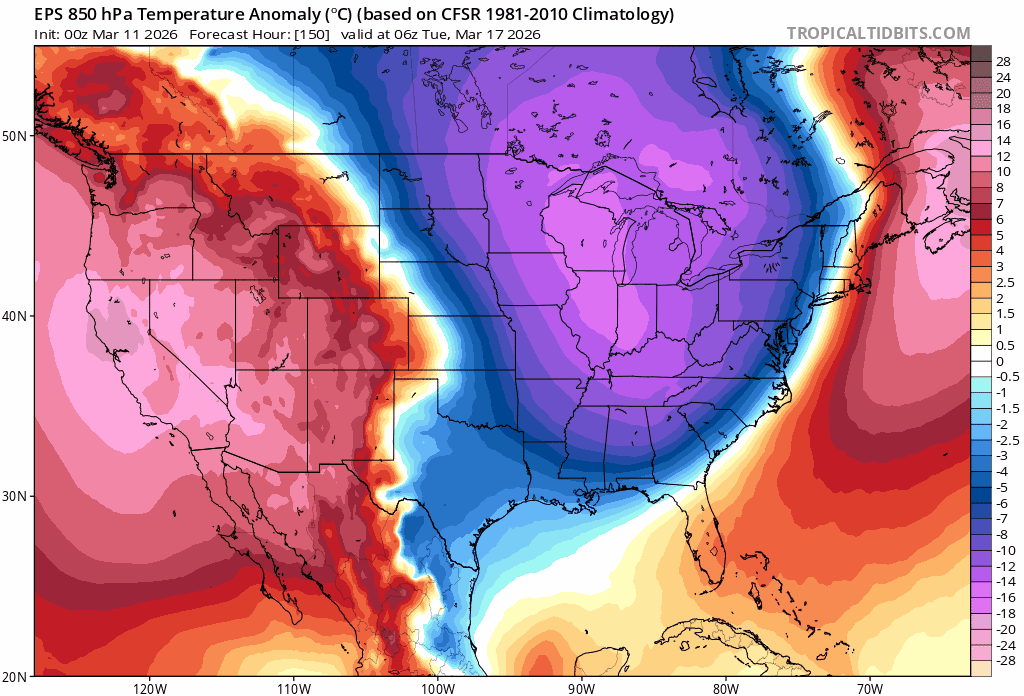
Looking ahead to next week, an intense ridge of high pressure remains on-track to bulldoze into the West. Colorado is staring down a multi‑day, late‑winter heatwave beginning Tuesday. The European ensemble temperature anomaly forecast animation below tells the story: a massive, persistent heat dome parked over the West for nearly a week straight. For mid‑March, the magnitude and duration of this feature are essentially unprecedented. Our area is likely to experience several consecutive days in the 80s. To put that into historical context, Boulder has only experienced 80° temperatures in March seven times in the last 140 years — 3 times in 1910, and then one time each in 1997, 2012, 2015 and 2017. Brace yourself for that familiar hum of air conditioning units next week, much sooner than anyone could expect.
Higher up, this magnitude of warmth will kick off Mountain snowmelt far earlier than normal. After this heatwave, and potentially another waiting in the wings for late March, the West will find itself in a critical state with historically low snowpack in a overwhelming majority of river basins. West-wide water availability for the upcoming summer is becoming more and more concerning with each passing day and each long-range model run we’re seeing. At this point, there is little hope for Front Range cities to avoid water restrictions, perhaps beginning as early as sometime in April. Folks downstream of our Mountains in the American Southwest will have ever bigger problems to worry about than we do.
Bottom Line
In the coming days we’ll be bouncing from windstorms to fire danger to a quick shot of weekend snow, only to rocket straight into a mid‑March heatwave next week that will feel more like late April or May. We know it’s a lot to take in, but the impacts will be real — from critical fire risk to damaging winds in the Foothills, to early Mountain snowmelt. This is still certainly a complex, evolving forecast, so be sure to check back for updates in the days ahead. Subscribe in the form below to be notified immediately when our next forecast goes live. Stay safe and please don’t be the cause of our next wildland fire!
Spread the word, share our crazy Colorado weather:
Go Premium, get all the perks.
Daily Forecast Updates
Get our daily forecast discussion every morning delivered to your inbox.
All Our Model Data
Access to all our Colorado-centric high-resolution weather model graphics. Seriously — every one!
Ski & Hiking Forecasts
6-day forecasts for all the Colorado ski resorts, plus more than 120 hiking trails, including every 14er.
Smoke Forecasts
Wildfire smoke concentration predictions up to 72 hours into the future.
Exclusive Content
Weekend outlooks every Thursday, bonus storm updates, historical data and much more!
No Advertisements
Enjoy ad-free viewing on the entire site.


You must be logged in to post a comment.