After a devastating spring snowstorm barely more than a week ago, a slow‑moving May storm parked itself over the northern Front Range, wringing out 1–2 inches of moisture and dropping a fresh blanket of wet snow in the Foothills — all without giving the lower elevations any freezing temperatures. For mid‑May, that’s about as friendly as a storm of this size gets. And with the larger‑scale trough refusing to budge, we’re not done yet: this week will feature more daily shower chances through Friday before drier, warmer weather returns just in time for the holiday weekend. Read on for all the details.
This week’s highlights include:
Soggy Storm Recap
- 🌧️ Second major storm in 10 days drenched the northern Front Range, delivering 36 hours of continuous moisture from thunderstorms to upslope rain and Foothills snow.
- 🌡️ Warmer storm profile spared the lower elevations from snow and freezing temps, making this an great mid‑May setup for drought relief.
- 📍 Boulder & Larimer Counties scored big again with 1–2″ of liquid, while most of Denver picked up 0.5–1.0″. Boulder officially logged 1.44″.
- ❄️ Snow levels bottomed out near 6500–7000 ft, producing 1–5″ in the lower/mid Foothills and 5–10″ higher up — slightly above our forecast.
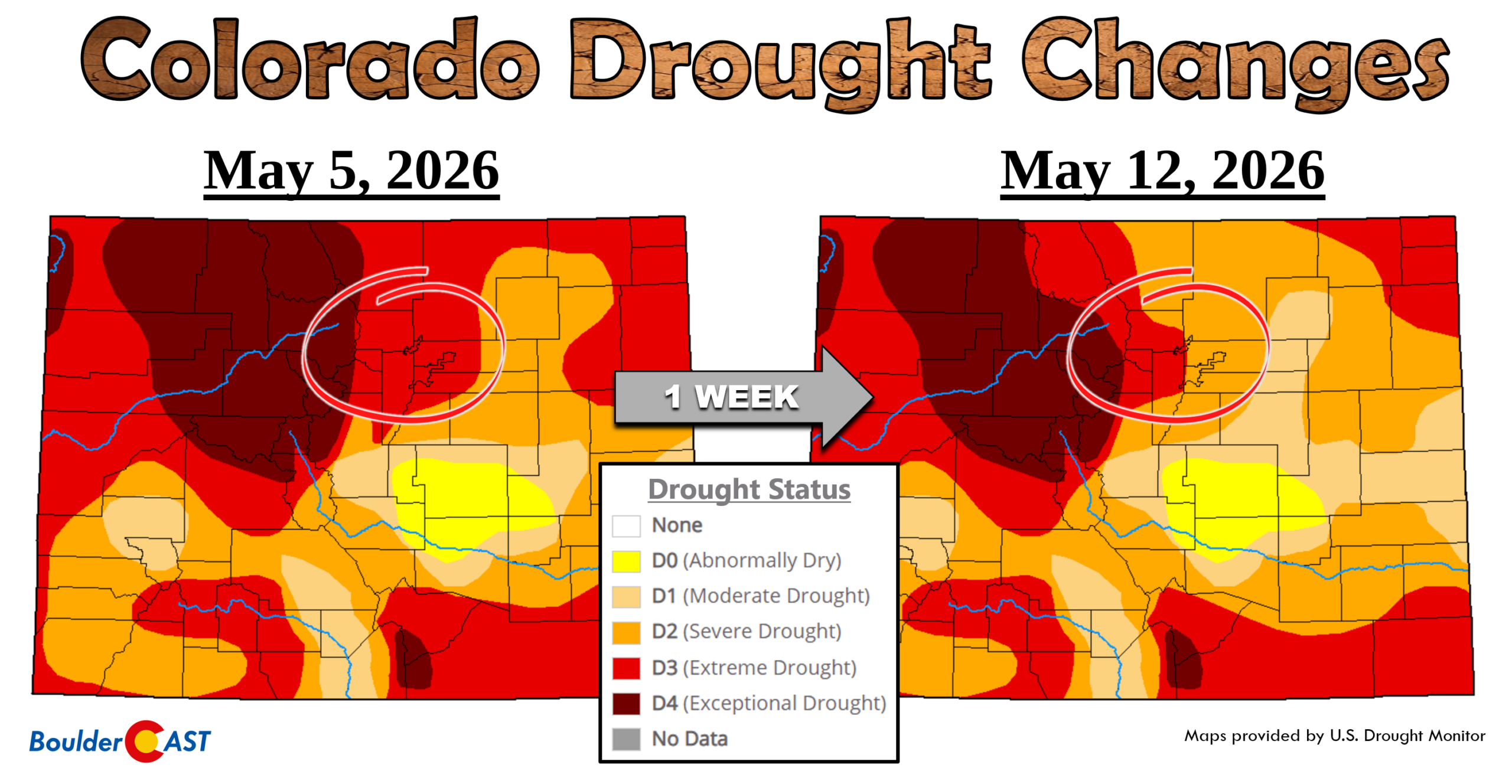
- 💧 Another categorical drought improvement is likely as a result of this storm, with more precipitation chances lined up through the rest of the week.
The Rest of the Week
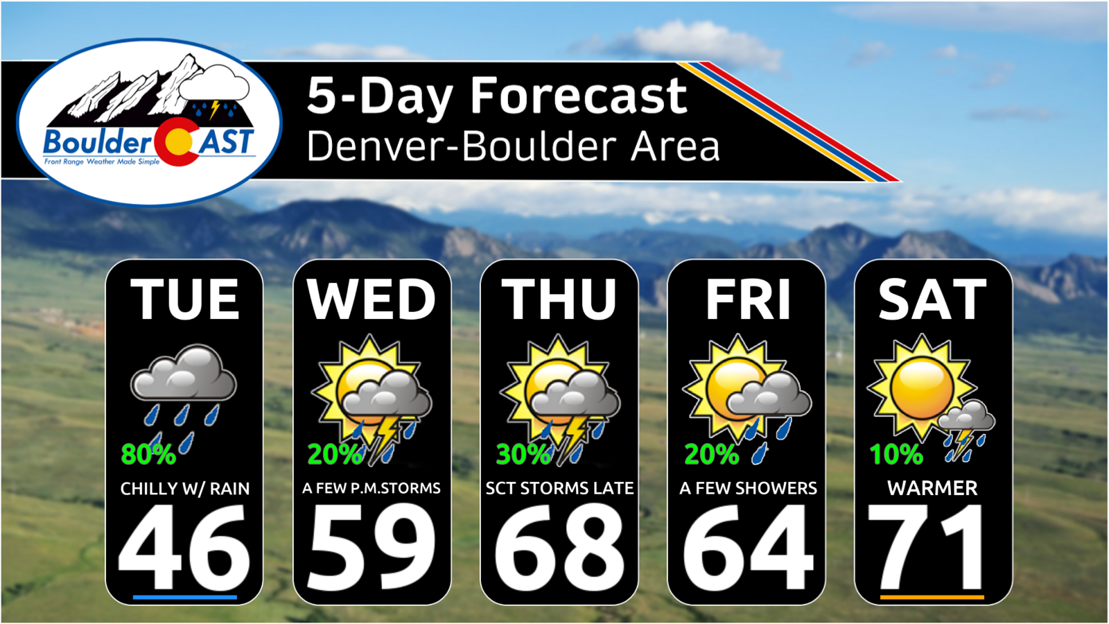
- 🌦️ Cool, unsettled pattern persists through Friday as a stubborn trough keeps northwest flow locked over northern Colorado with daily shower/storm chances.
- 📉 Tuesday brings the best additional rainfall potential, with jet‑forced bands capable of another 0.25–0.50″ (more along I‑70 into the Foothills where it will be snow).
- 🌤️ Holiday weekend turns warmer and drier as a ridge builds in — highs return to the 70s Saturday and possibly 80s Sunday, before more storm chances pick up again next week.
DISCLAIMER: This weekly outlook forecast is created Monday morning and covers the entire upcoming week. Accuracy will decrease as the week progresses as this post is NOT updated. To receive daily updated forecasts from our team, among many other perks, subscribe to BoulderCAST Premium.

Go Premium, get all the perks.
Daily Forecast Updates
Get our daily forecast discussion every morning delivered to your inbox.
All Our Model Data
Access to all our Colorado-centric high-resolution weather model graphics. Seriously — every one!
Ski & Hiking Forecasts
6-day forecasts for all the Colorado ski resorts, plus more than 120 hiking trails, including every 14er.
Smoke Forecasts
Wildfire smoke concentration predictions up to 72 hours into the future.
Exclusive Content
Weekend outlooks every Thursday, bonus storm updates, historical data and much more!
No Advertisements
Enjoy ad-free viewing on the entire site.
Another Soaking May Storm Delivers for the Northern Front Range
Just ten days after the damaging spring snowstorm earlier this month, another major system slammed the northern Front Range to start the week — targeting nearly the same areas with yet another prolonged dose of moisture. A surprisingly favorable blend of ingredients aligned for an extended 36‑hour window from Sunday afternoon through Tuesday morning. What began as hail‑producing thunderstorms gradually transitioned into a chilly, persistent upslope rain, with wet snow returning to the Foothills and Mountains. For drought‑stricken northern Colorado, this was exactly the kind of encore performance we needed from Mother Nature.
Fortunately, this second storm arrived several degrees warmer than the last. All precipitation across the lower elevations fell as rain rather than snow, and we even managed to avoid sub‑freezing temperatures on the backside of the system. For a storm of this magnitude in mid‑May, you really can’t script a better outcome.
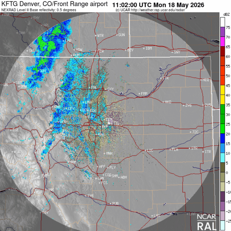
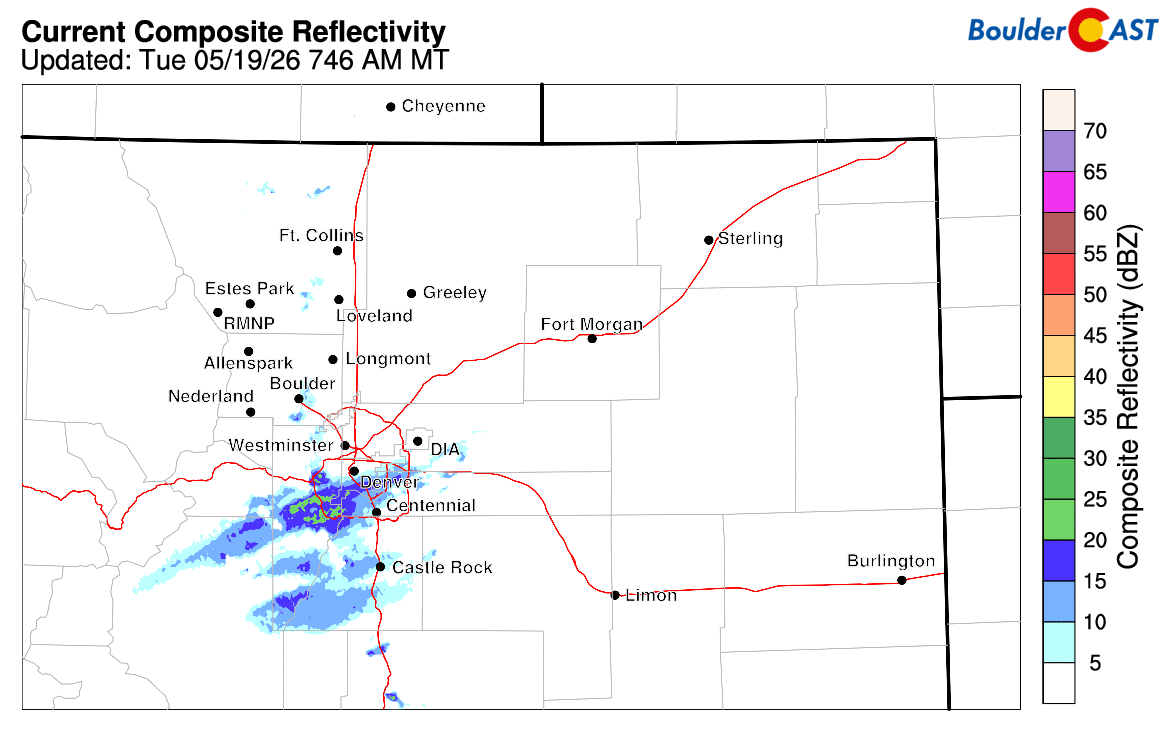
Denver area radar animation during the day Monday. Widespread rain and higher elevation snow!
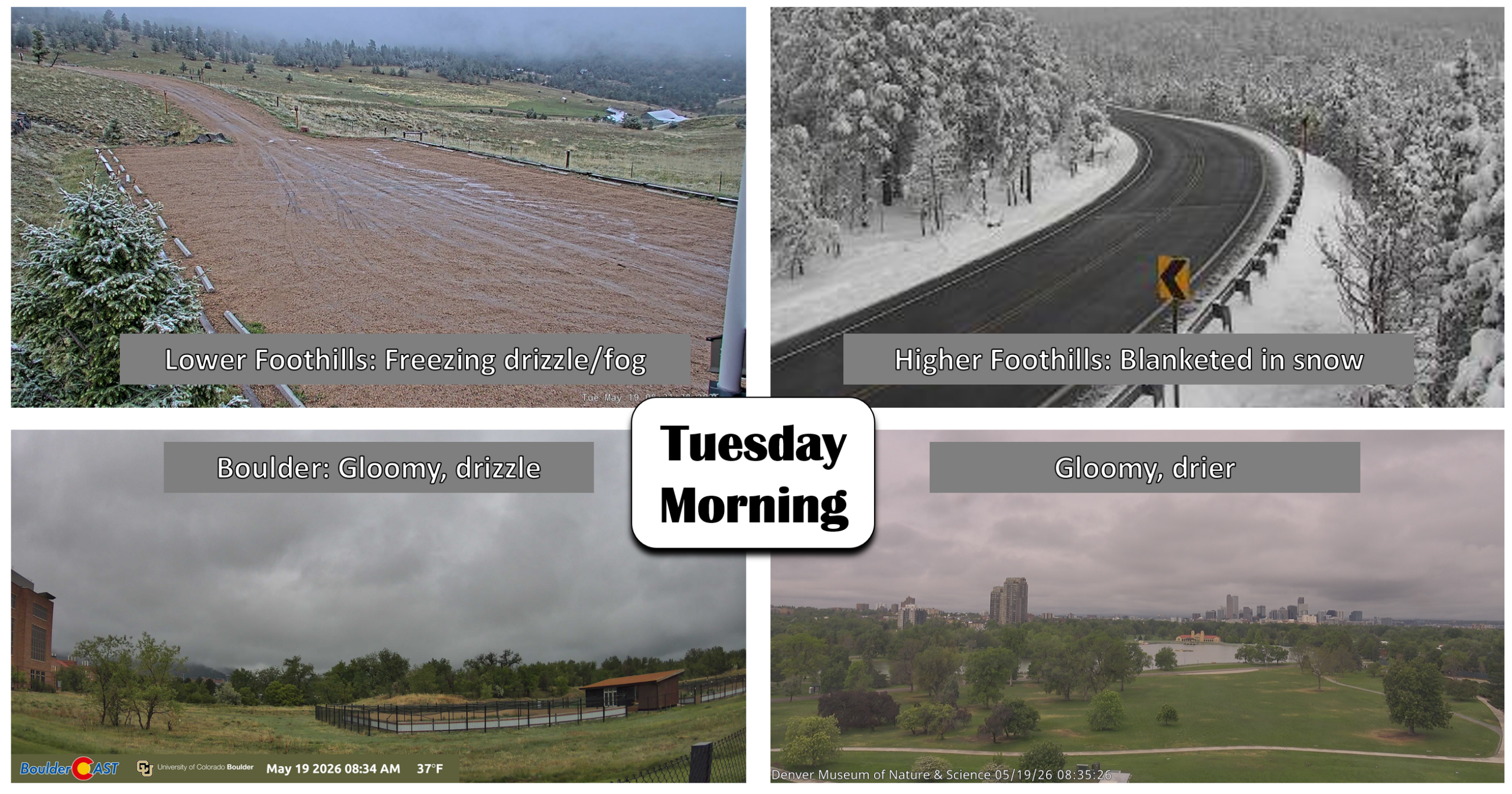
As of this writing Tuesday morning, light drizzle is still falling in Boulder — a fitting end to a stretch of nearly continuous precipitation spanning a day and a half.
Across the broader Front Range Tuesday morning, conditions vary dramatically by elevation. Boulder and Denver remain locked in lingering drizzle and low clouds. The lower Foothills are dealing with pockets of freezing fog and freezing drizzle. Meanwhile, the higher Foothills and Mountains are waking up to a full‑blown winter wonderland.
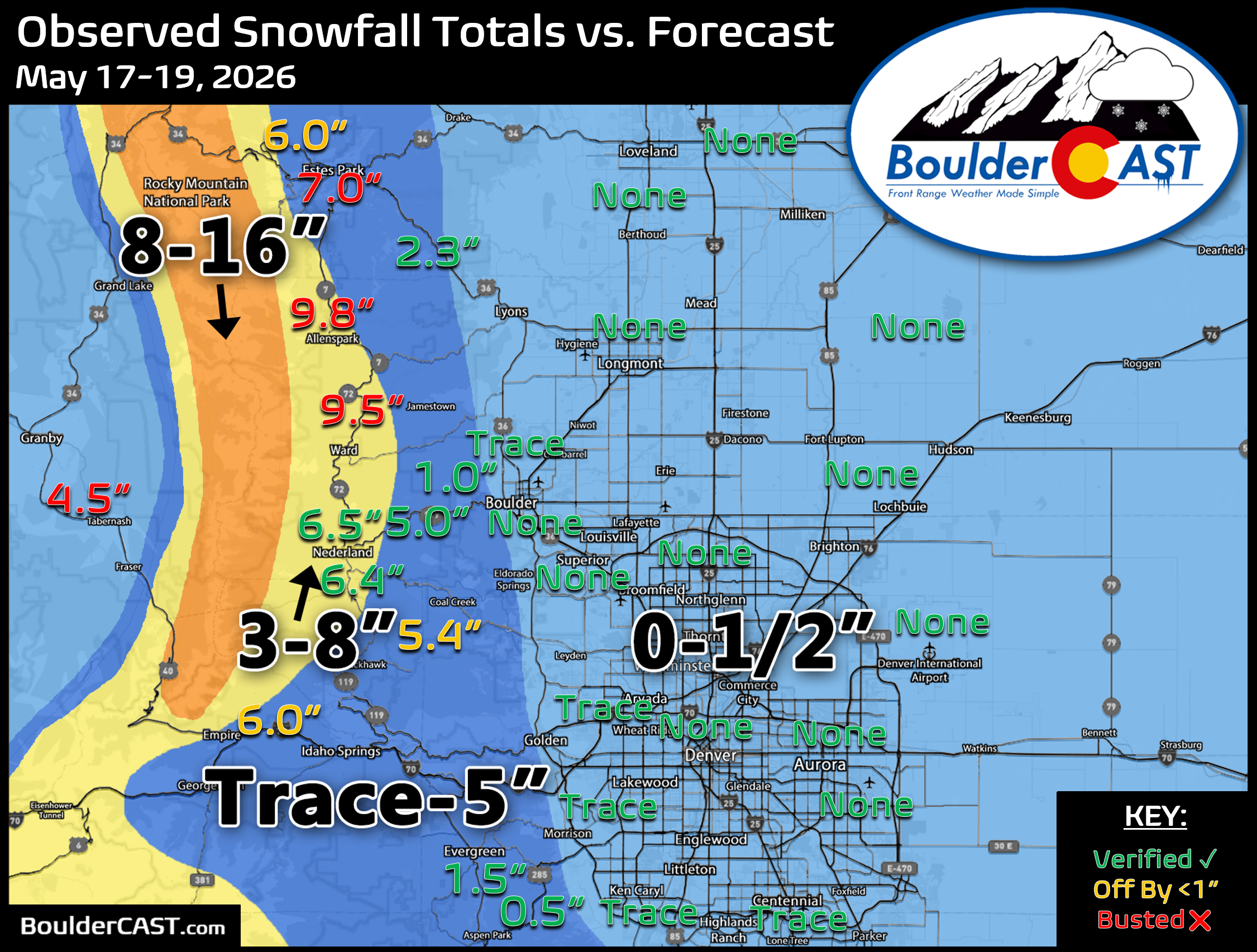
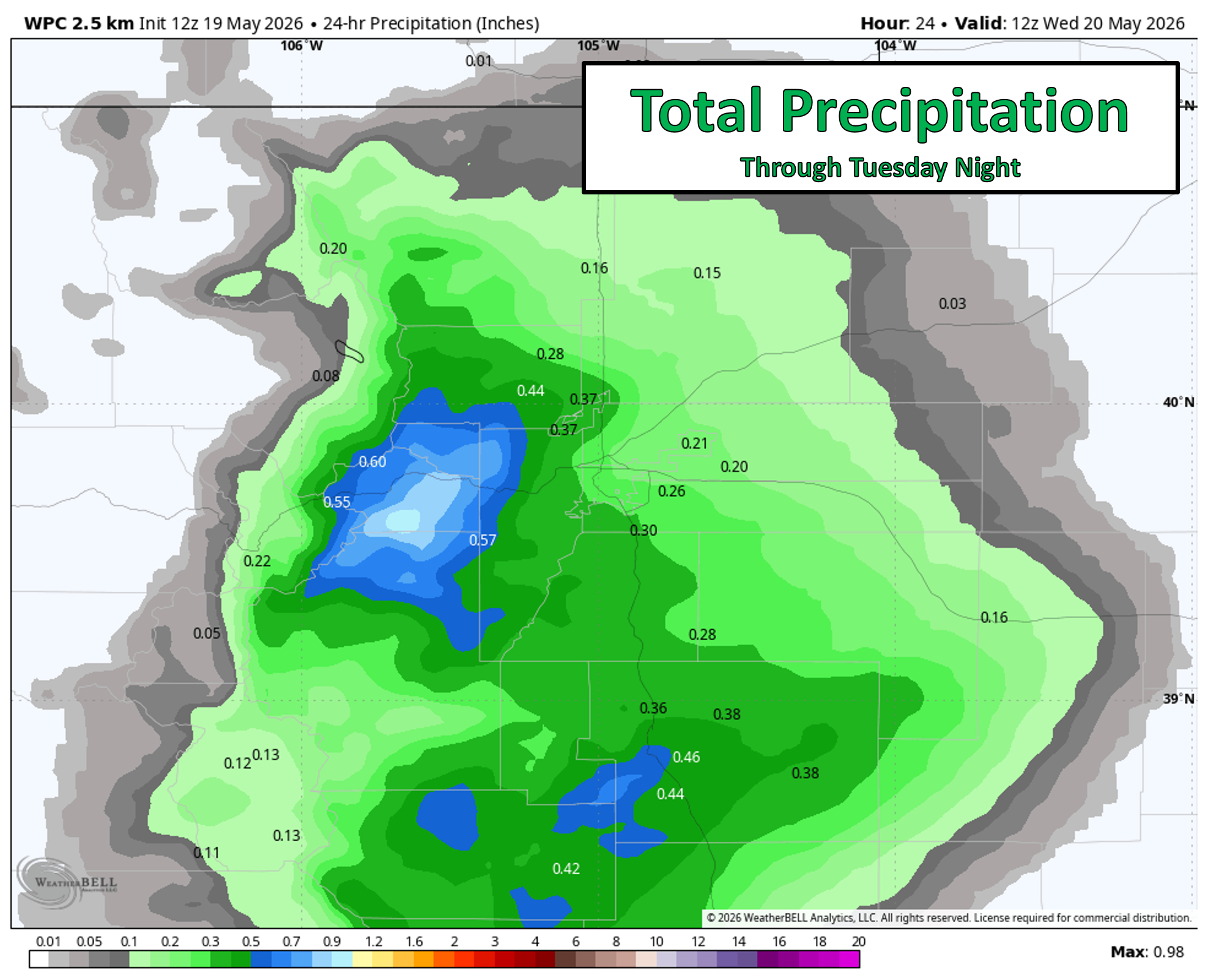
Storm‑total precipitation came in almost exactly as projected which is always nice to see. Boulder and Larimer Counties cashed in with widespread 1–2 inches of liquid. Farther south and east, most of Denver picked up between 0.5 and 1.0 inch.
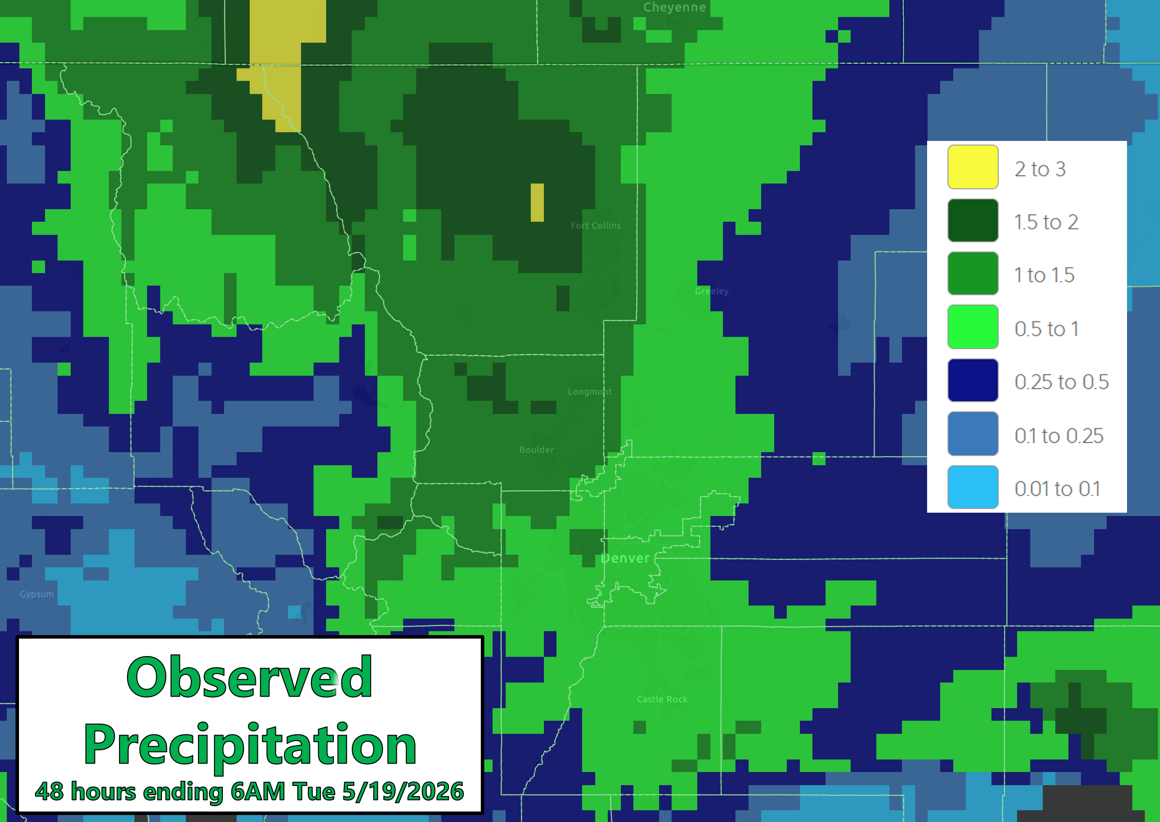
Zooming in on Boulder County, nearly every gauge topped the 1‑inch mark, with the Foothills exceeding 1.5 inches in several spots.
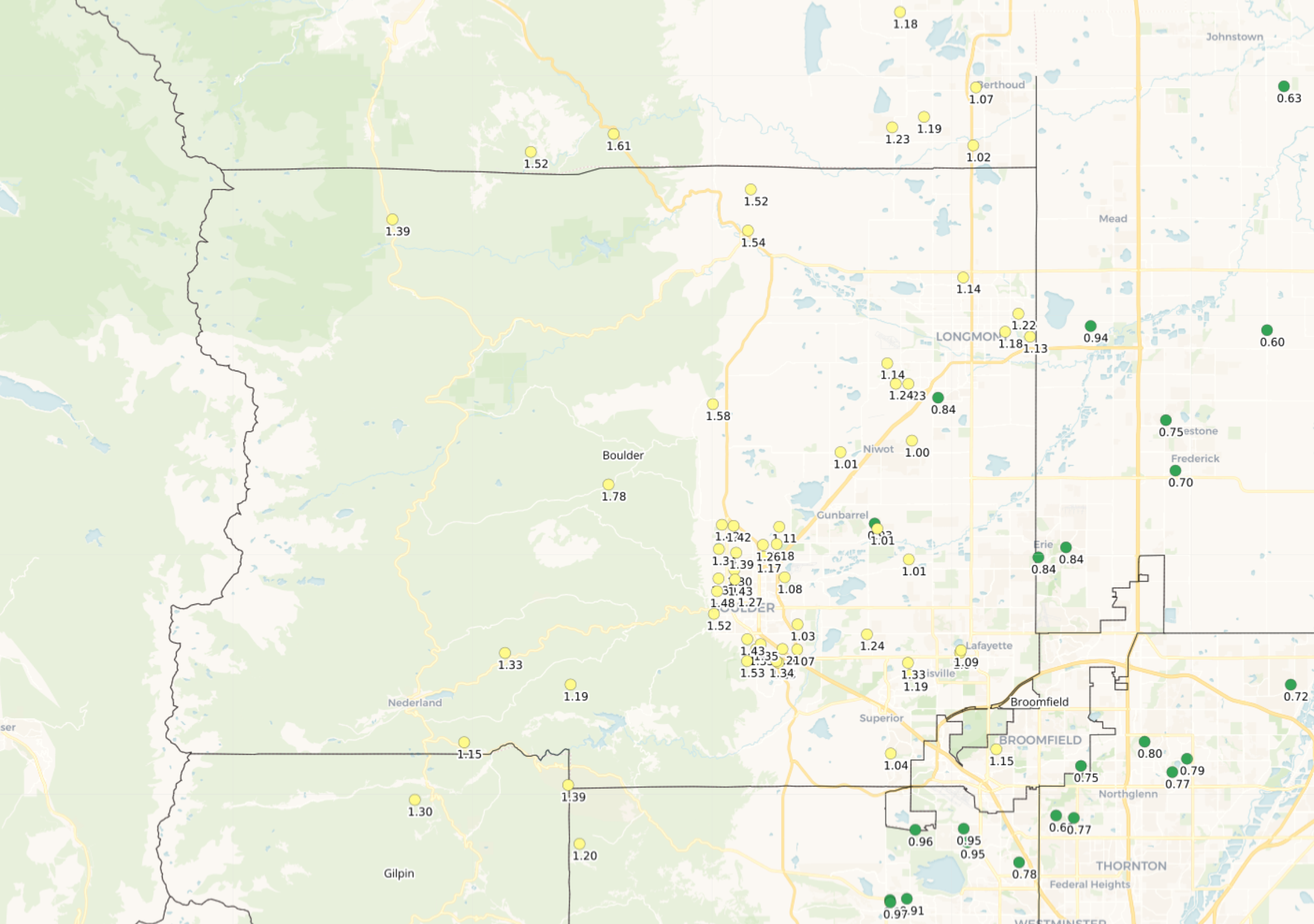
May 17-19, 2026 precipitation totals in Boulder County
Officially, Boulder recorded 1.44″ of rain, while Denver (DIA) logged 0.40″. Neither city reported snow, though wet flakes did mix in at times Monday afternoon in our part of town — we’re calling it a trace here.
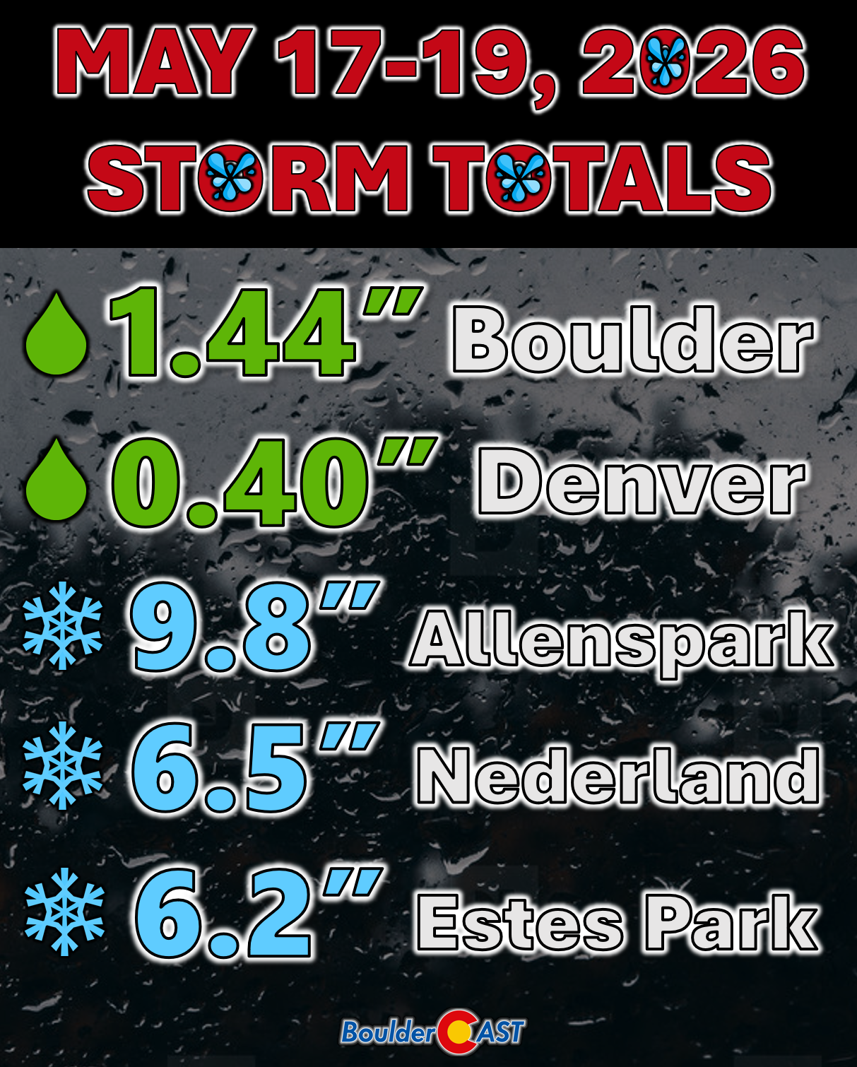
The higher terrain didn’t escape the wintry impacts like the lower elevations, with snow levels generally holding above 6500–7000 feet. The lower and middle Foothills picked up 1–5 inches, while the higher Foothills and Mountains tallied 5–10 inches — a bit above our forecast. But given the long duration of the event, the deep moisture plume, and the constantly fluctuating snow levels, this was always going to be a highly elevation‑dependent storm with wide variability. We can’t really complain here.
With another 1–2 inches of moisture added to the bucket across Boulder and Larimer Counties, we’re likely to see another categorical improvement in drought classification this week. And as we’ll discuss shortly, continued precipitation chances through the rest of the week leave the door open for even more improvement.
May Showers Continue Through the Week
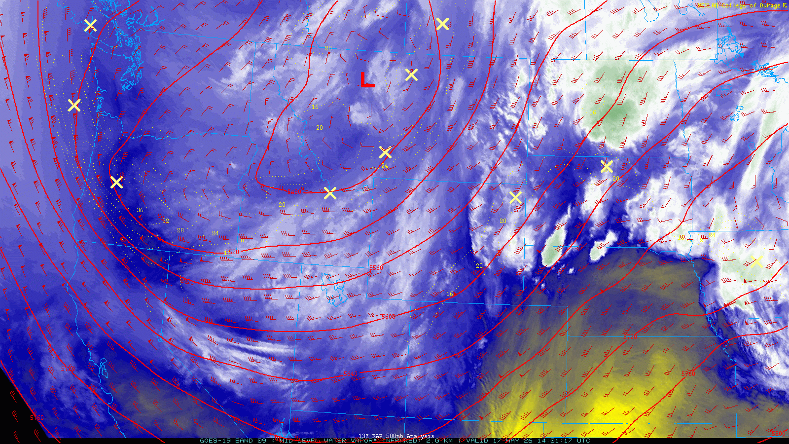
A cool, unsettled pattern will dominate the Front Range through Friday as this stubborn trough refuses to budge. This will lock in northwest flow across northern Colorado, with several reinforcing shots of cooler Canadian air sliding southward in the days ahead.
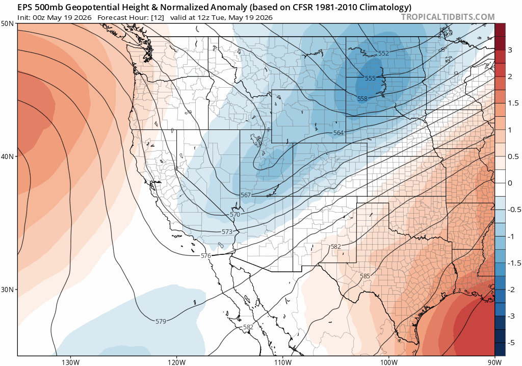
Euro ensemble mean 500mb pattern for the rest of the week showing the lingering troughy setup over Colorado, and hints of a ridge moving in by the weekend.
Embedded shortwaves and lingering moisture will combine to produce daily chances for showers and thunderstorms the rest of the week.
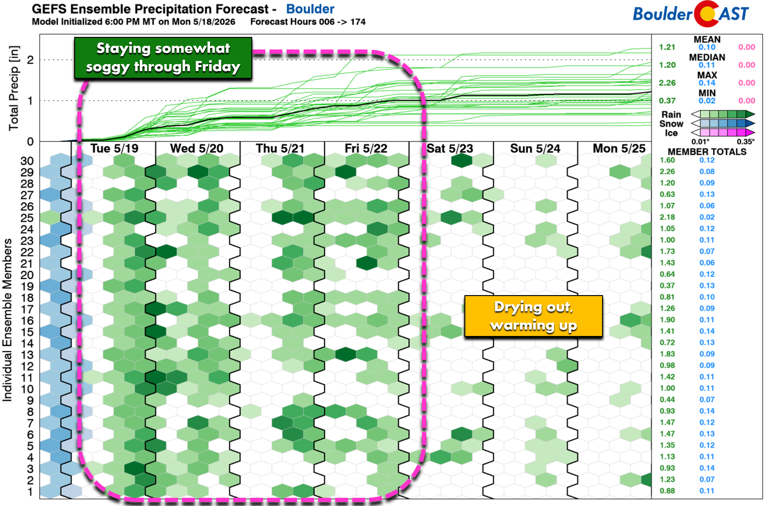
Tuesday
Today brings perhaps our best chance for additional meaningful rainfall this week. Even though the main storm system has weakened and shifted east, leftover moisture, modest instability, and a boost of upper‑level jet energy will keep the atmosphere primed for more precipitation.
Morning drizzle and low clouds may briefly thin around midday, but additional bands of rain — and Foothills snow showers — will redevelop quickly by afternoon. Precipitation will linger into the evening and overnight hours for portions of the Denver Metro area before finally tapering late Tuesday night or early Wednesday.
The HRRR simulated radar shows a particularly active period around Boulder during the afternoon/evening, with activity shifting more toward Denver Tuesday night.
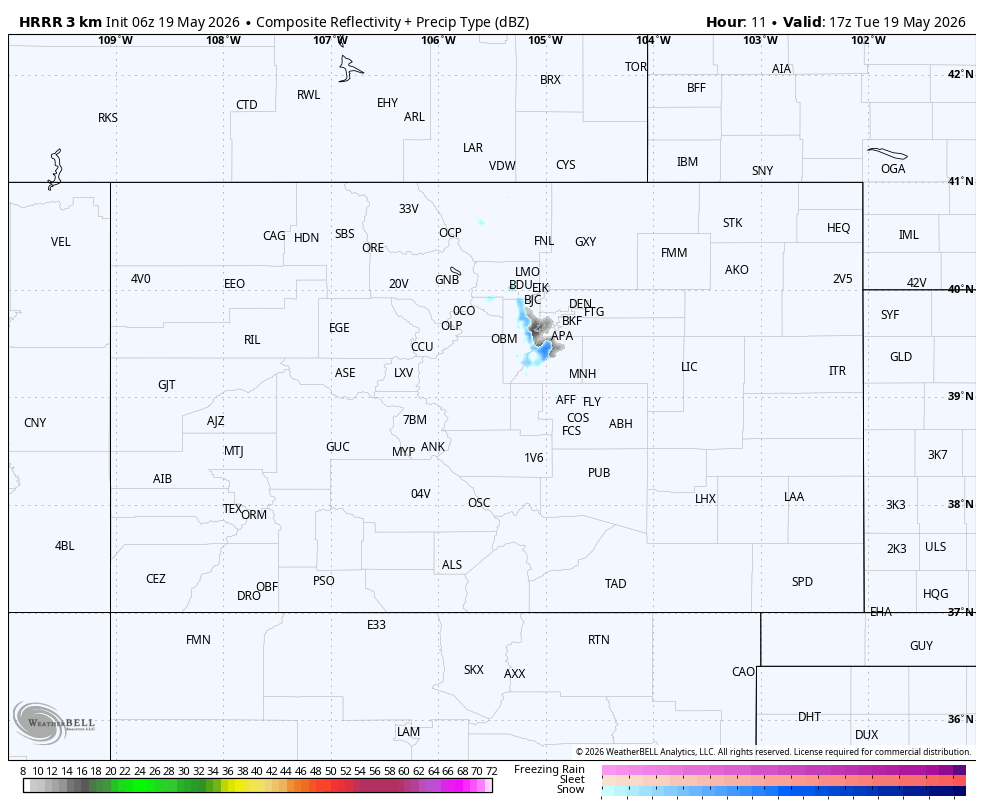
HRRR simulated radar animation for Tuesday into Wednesday
Totals could be surprisingly impressive: slow‑moving, jet‑enhanced rain and snow bands may deliver 0.25–0.50″ of additional moisture by Wednesday morning. The I‑70 corridor into the Foothills is favored for over 0.5″, much of it falling as snow above 7500 feet.
For Boulder and Denver, Tuesday will be a raw, chilly day with highs stuck in the 40s and numerous to widespread bands of rain developing through the afternoon, evening, and overnight.
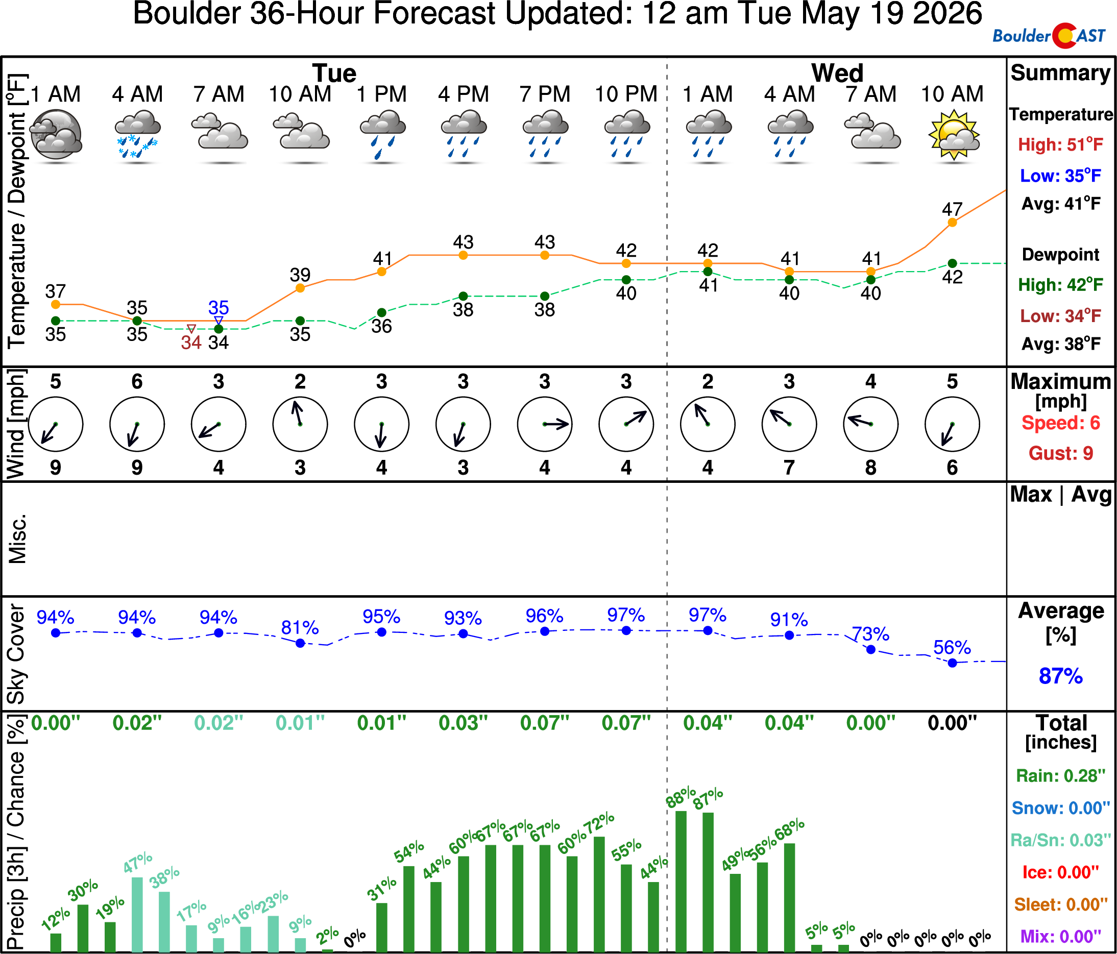
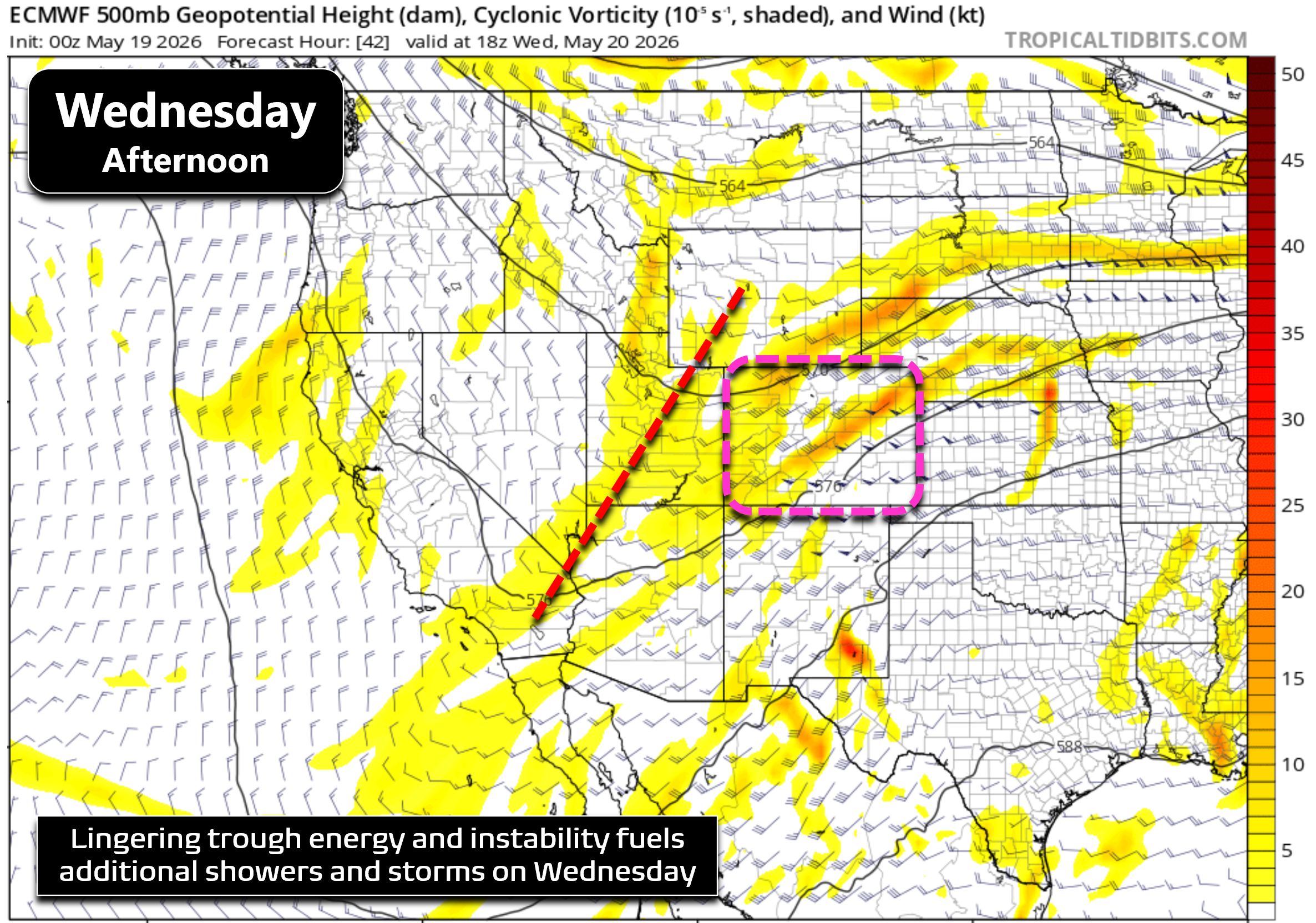
Wednesday
Most of Tuesday night’s showers should be gone by sunrise Wednesday, leaving behind lingering clouds. Some sunshine will break through during the day, but that heating will only help fuel another round of afternoon and early‑evening showers and storms.
A slow‑moving broad trough will still be parked over Utah, with downstream forcing extending into Colorado. However, the best lift on Wednesday shifts south of Denver, meaning rain chances locally drop to around 20%. Highs will rebound into the upper 50s.
Thursday
Attention turns to a reinforcing cold front tied to a clipper-type system dropping into northern Colorado from the Canadian Prairies. Ahead of the front, temperatures will warm into the upper 60s with a chance for scattered thunderstorms.
Right now, the front appears likely to arrive Thursday night — too late to overlap with daytime instability. But timing is still uncertain, and even an overnight arrival could spark additional showers and storms across eastern Colorado through Thursday night and early Friday.
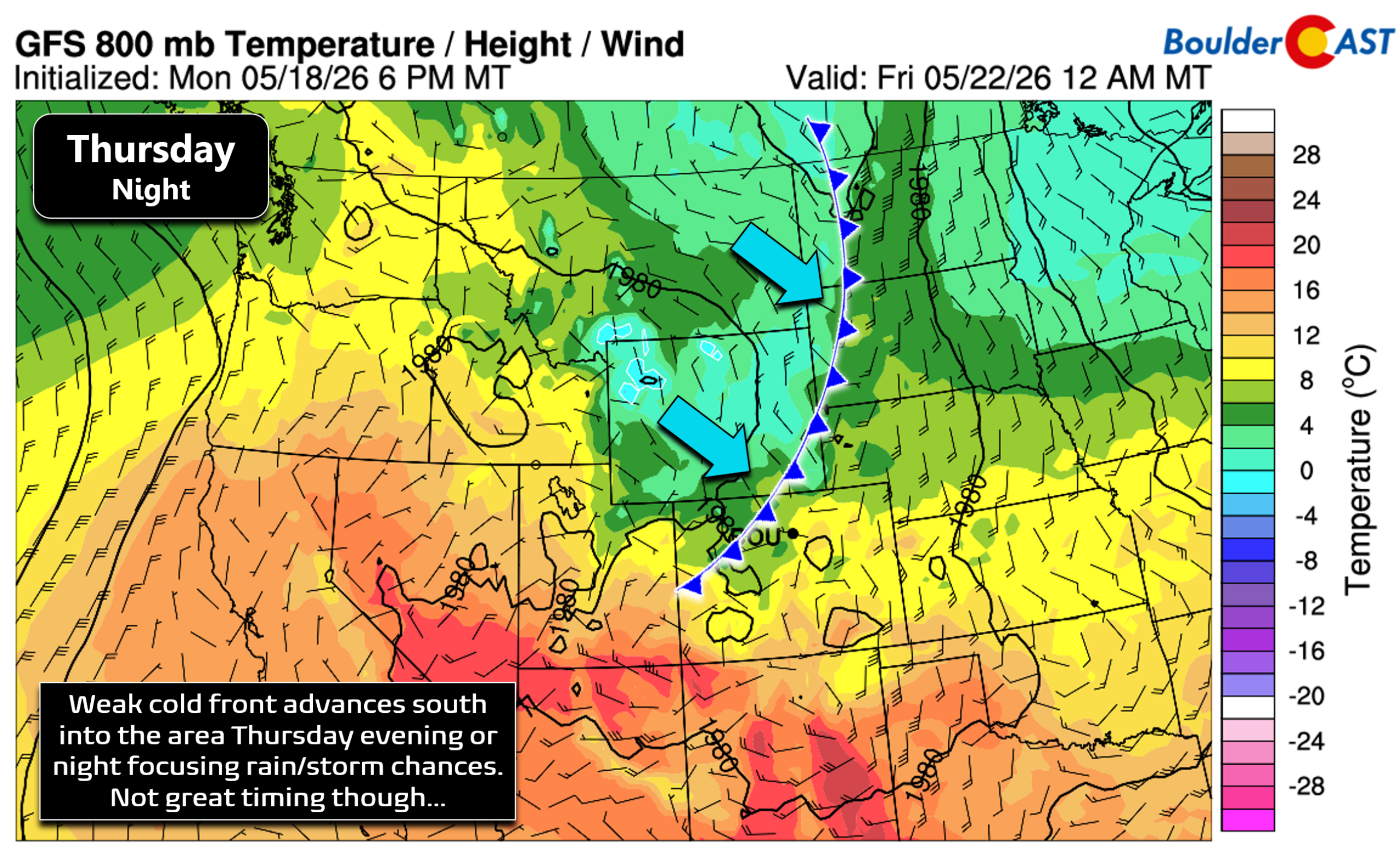
For now, expect widely scattered late‑day thunderstorms Thursday, with storm chances lingering well into the night as the front moves in.
Friday
Friday will be slightly cooler and more stable behind the front. Partly cloudy skies will dominate, with only a slight chance (10–20%) of a late‑day shower drifting off the higher terrain. The front is expected to stall or wash out across southeast Colorado, keeping the bulk of Friday’s storm activity well south of the Boulder–Denver corridor.
Memorial Day Weekend
By Saturday, the persistent trough finally shifts east, replaced quickly by a developing ridge building into the Four Corners by Sunday and Monday.
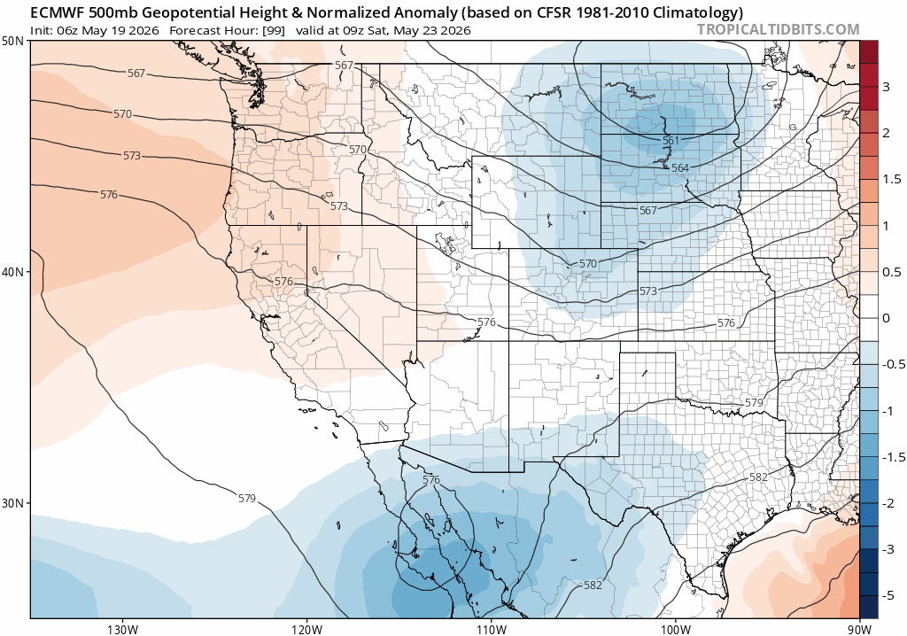
Euro 500mb pattern for the weekend showing a ridge building over the West which will bring warmer, drier weather to Colorado
This will usher in a drying and warming trend for the Front Range. Our long stretch of below‑normal temperatures should end Saturday — and if not, certainly by Sunday. Highs will climb into the lower 70s Saturday and potentially the lower 80s Sunday. Memorial Day is looking swell too, with highs likely around 80 to 85° and just a slight late-day storm risk.
Despite daily shower and thunderstorm chances through the work week, the pattern improves just in time for a genuinely pleasant holiday weekend across the Front Range. While there will probably be some chances for late-day thunderstorms each day of the weekend, especially Monday, they should be few and far between and more likely over the Mountains. For now, we’re not expecting any major disruptions to outdoor plans, but as always, that can change given the lead time so stay tuned.
Next week looks warmer than normal for at least part of the period, but another broad Pacific trough approaching the West Coast will reintroduce shower and storm chances eventually.
A Promising Long‑Range Outlook
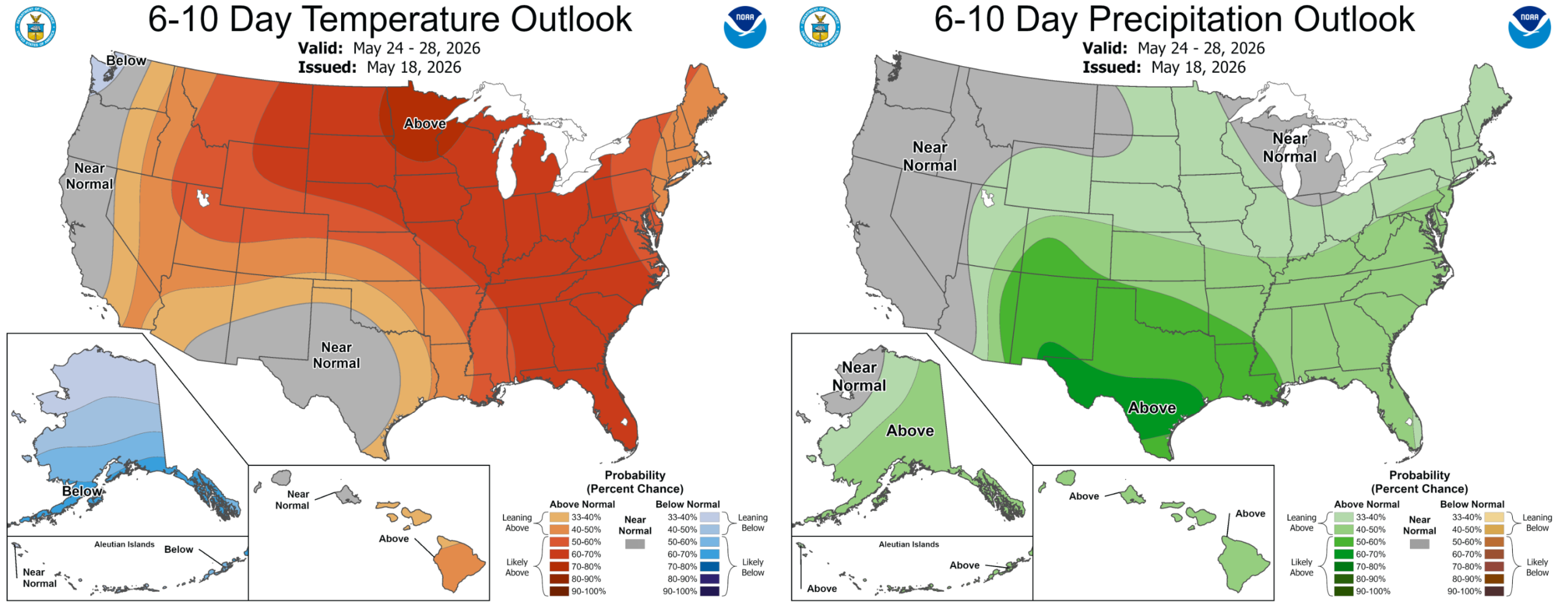
It’s hard not to feel optimistic about the remainder of May heading into June. The Climate Prediction Center continues to highlight increased odds of above‑normal temperatures — but more importantly, above‑normal precipitation — for all of Colorado.
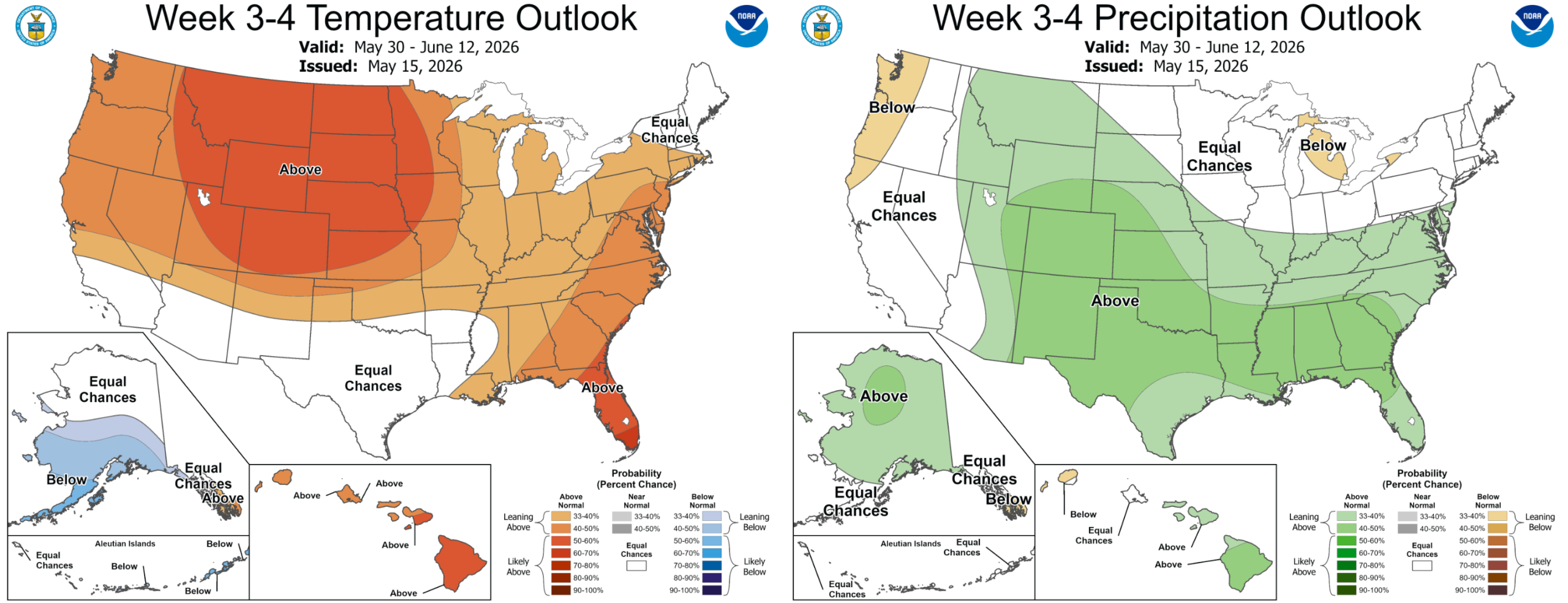
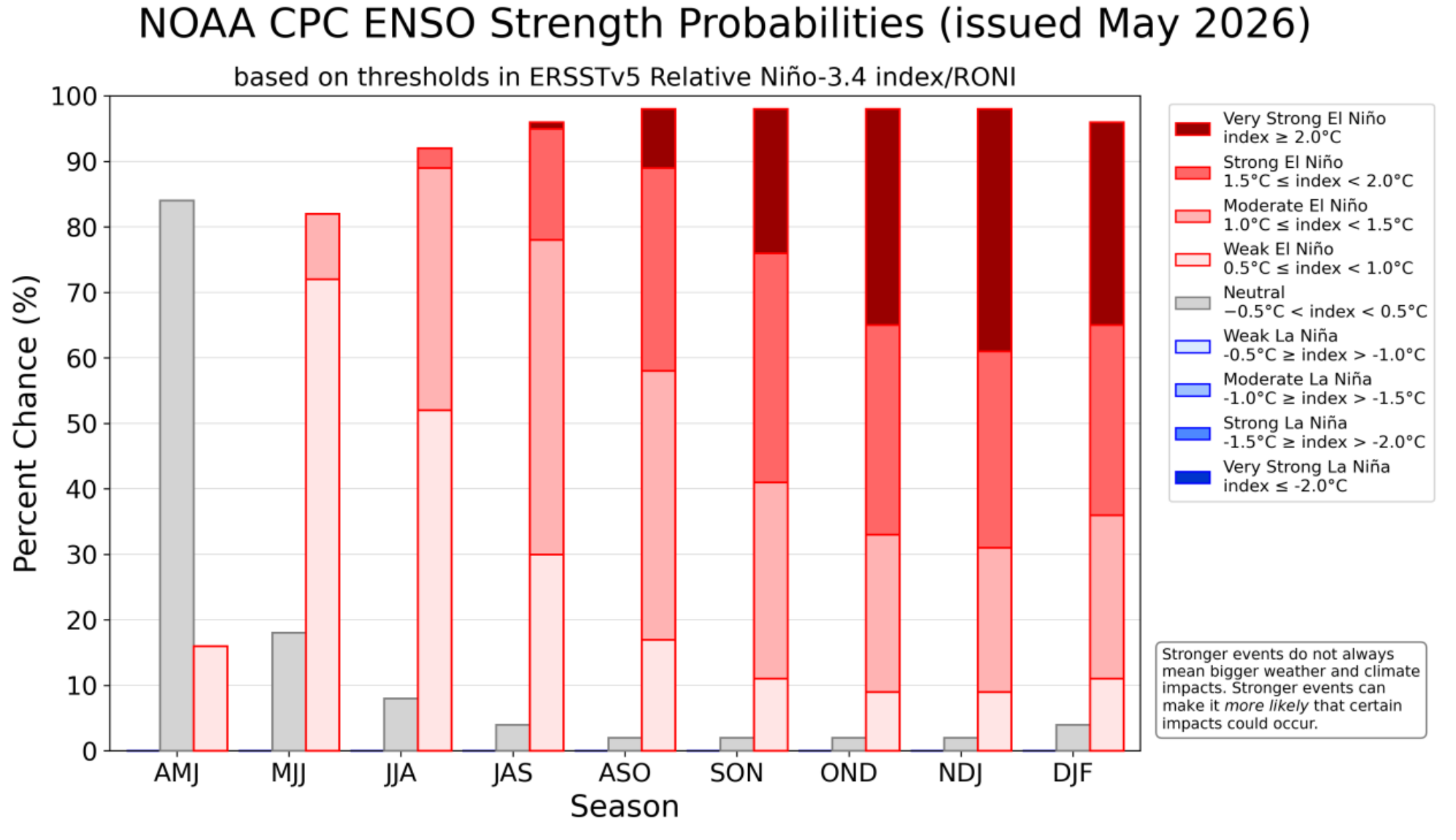
Those two regimes don’t often occur together, making the forecast somewhat unusual. But given the ongoing drought, we’ll gladly take any moisture we can get. If the pattern verifies, the Front Range may be able to chip away at the worst of the drought before summer heat arrives in earnest. We’re not ready to count on that outcome just yet, but the door is open, especially with El Niño coming in hot.
Enjoy the cool, wet work week and the beautiful holiday weekend thereafter!
Forecast Specifics:
Tuesday: Morning drizzle, fog and mist in and near the Foothills (with freezing fog and freezing drizzle above 6500 feet). After drying out around midday, showers will quickly redevelop during the afternoon with chilly rain (Foothills snow) continuing into the overnight. Highs only in the 40s across the lower elevations with 30s in the Foothills.
Wednesday: Partly cloudy early becoming mostly cloudy later in the day with a few widely scattered late-day storms, mainly south of Denver. Highs creep up towards 60° on the Plains with upper 40s in the Foothills.
Thursday: Morning sun and then increasing clouds with scattered late-day showers and storms. Storm chances linger into Thursday night or even early Friday morning along the passage of a cold front. Highs reach the upper 60s for the Plains with middle 50s in the Foothills.
Friday: A tad cooler and more stable with only a slight chance for a late-day shower coming off the terrain. Highs in the middle 60s on the Plains with lower 50s in the Foothills.
Memorial Day Weekend: Drying and warming ensue with just a slight chance of a late-day isolated storm both days. Highs will reach the lower 70s by Saturday and potentially the lower 80s on Sunday. Memorial Day currently looks to land in the low to middle 80s with a slight chance of a late-day storm. What a great transition into the holiday weekend after a soggy, cool week!
DISCLAIMER: This weekly outlook forecast is created Monday morning and covers the entire upcoming week. Accuracy will decrease as the week progresses as this post is NOT updated. To receive daily updated forecasts from our team, among many other perks, subscribe to BoulderCAST Premium.
Go Premium, get all the perks.
Daily Forecast Updates
Get our daily forecast discussion every morning delivered to your inbox.
All Our Model Data
Access to all our Colorado-centric high-resolution weather model graphics. Seriously — every one!
Ski & Hiking Forecasts
6-day forecasts for all the Colorado ski resorts, plus more than 120 hiking trails, including every 14er.
Smoke Forecasts
Wildfire smoke concentration predictions up to 72 hours into the future.
Exclusive Content
Weekend outlooks every Thursday, bonus storm updates, historical data and much more!
No Advertisements
Enjoy ad-free viewing on the entire site.
Enjoy our content? Give it a share!


You must be logged in to post a comment.