Category: Tropical Weather (Page 1 of 20)

This Week in Colorado Weather: July 27, 2026

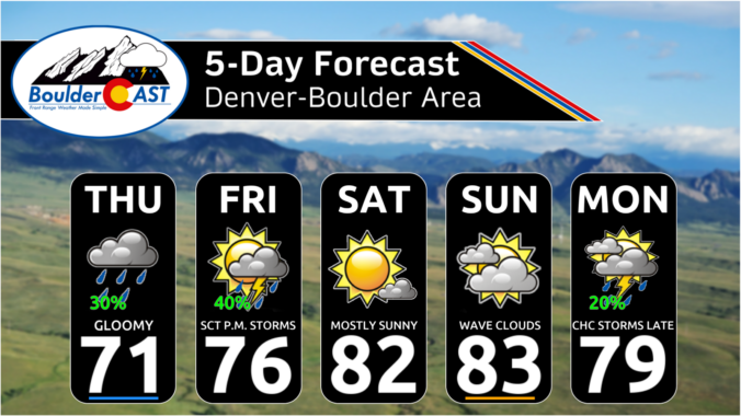
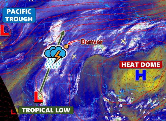
Eastern Colorado just came off a truly blistering weekend, with Denver and Boulder both shattering daily records as temperatures surged past 100°F on back‑to‑back days. Now the pattern is shifting, at least temporarily. An unusually juiced monsoon plume will set the stage for more robust afternoon storms through mid‑week, including a legitimate threat for locally heavy rainfall and burn‑scar flooding. But the faucet will shut off quickly. A rapidly intensifying Southwest heat dome will retrograde into Arizona late‑week, cutting off monsoon flow, drying out northern Colorado, and potentially steering wildfire smoke from the Pacific Northwest into the state as winds shift. By the weekend, the Front Range will sit on the fringe of that expanding heat dome, meaning another round of hot, dry weather and potential triple-digit readings again. Read on for all the details.

Continue reading

Colorado Monsoon Update: Storm Coverage Explodes Midweek as Monsoon Moisture Finally Breaks Through Into the Front Range

A surge of true monsoon moisture is finally breaking through the Front Range’s persistent dry shield. After Tuesday night’s northern‑tier storms offered a preview, the next two days will bring the real deal: widespread convection, highly anomalous moisture, torrential rainfall rates, and the best shot at real rain we’ve had in weeks. If you’ve been waiting for a break from the seemingly never-ending heat of summer and a return of stormy skies, the next few days are poised to deliver.

Continue reading

This Week in Colorado Weather: July 20, 2026

After more than a week of relentless heat, the Front Range is finally heading into a pattern change — but not before we break a few records and squeeze out one more day near 100°. This week will bring a notable shift: true monsoon moisture is poised to surge over the Continental Divide, storm chances finally return and temperatures finally ease… at least for a moment. We break down what’s driving this stubborn heat, when the storms arrive, and why flash-flood concerns may quickly replace heat and fire danger as Colorado’s primary weather story.

Continue reading

Colorado Forecast Update: Fourth of July Weekend Brings Heat, Haze, and a Hint of Storms

Colorado has been stuck in a dry, windy southwest‑flow pattern all week that has led to more than 130,000 acres of forest and shrubland burning across the state in nearly a dozen large fires. Now, as we head into the holiday weekend, the pattern finally shows some give: winds ease, temperatures climb, and a slow return of low‑level moisture should allow a few storms to sneak back into the Front Range. It’s not a full reset — meaningful rainfall will still be hard to come by for now — but the atmosphere is nudging Colorado toward a more familiar early‑July rhythm just in time for the Fourth. We break down how this evolving setup will shape the weekend’s weather, fire danger, and your outdoor plans.

Continue reading

This Week in Colorado Weather: May 19, 2026

After a devastating spring snowstorm barely more than a week ago, a slow‑moving May storm parked itself over the northern Front Range, wringing out 1–2 inches of moisture and dropping a fresh blanket of wet snow in the Foothills — all without giving the lower elevations any freezing temperatures. For mid‑May, that’s about as friendly as a storm of this size gets. And with the larger‑scale trough refusing to budge, we’re not done yet: this week will feature more daily shower chances through Friday before drier, warmer weather returns just in time for the holiday weekend. Read on for all the details.

Continue reading

El Niño Is Coming — But Colorado Likely Faces a Hyperactive Fire Season First

Colorado headlines have been buzzing about a looming “Super El Niño,” but the story behind the hype is far more layered than the headlines let on. Before leaning into the dramatic graphics and sweeping claims, it’s worth unpacking where this narrative actually came from and why one overzealous model run has taken on a life of its own. More importantly, we must consider what this all really means for our state as we limp into summer with record‑low snowpack, deepening drought, and a fire season that has already been sharpening its teeth. The truth is far more nuanced than the current online discourse suggests.

Continue reading

October 2025 Graphical Weather Review: A warm & dry month that prolonged the growing season, delayed our first snow

October 2025 was definitively warm and dry throughout the Front Range with the primary storm track remaining well north across Wyoming and Montana. The only real precipitation event during the month occurred on October 6th with some locations picking up more than one half inch of rain. Our first frost of the season occurred about two weeks later than normal, and to this day we’re still waiting for those magical first snowflakes across the lower elevations. Here’s a quick and colorful graphical recap of our weather during October and how it relates to climatology.

Continue reading

« Older posts