

The Front Range got a welcome surprise overnight as a steady rain event delivered more moisture than many locations were expecting. While today’s clouds, fog, and cool temperatures will keep autumn firmly in charge, they’re also the beginning of a much quieter stretch of weather ahead. Mother Nature will flip the script again with sunshine and temperatures climbing well above normal the rest of the week but don’t get too comfortable. Forecast models are already hinting at our next potential storm opportunity just beyond Halloween.
This week’s highlights include:
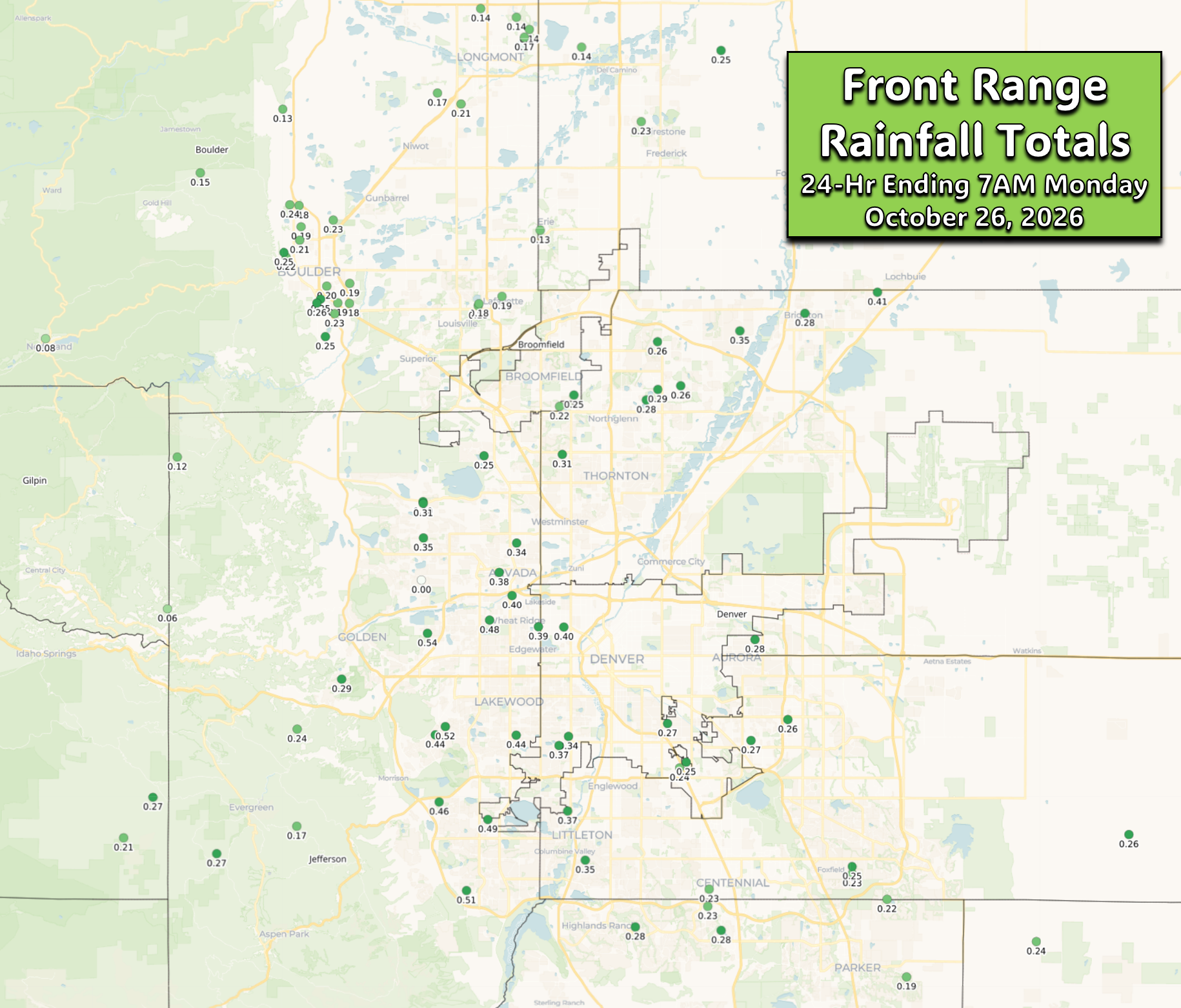
- 🌧️ Rain Delivers More Than Expected — A welcome overnight soaking brought 0.25″ to 0.50″+ of rain to much of the Front Range, giving October’s moisture totals another healthy boost.
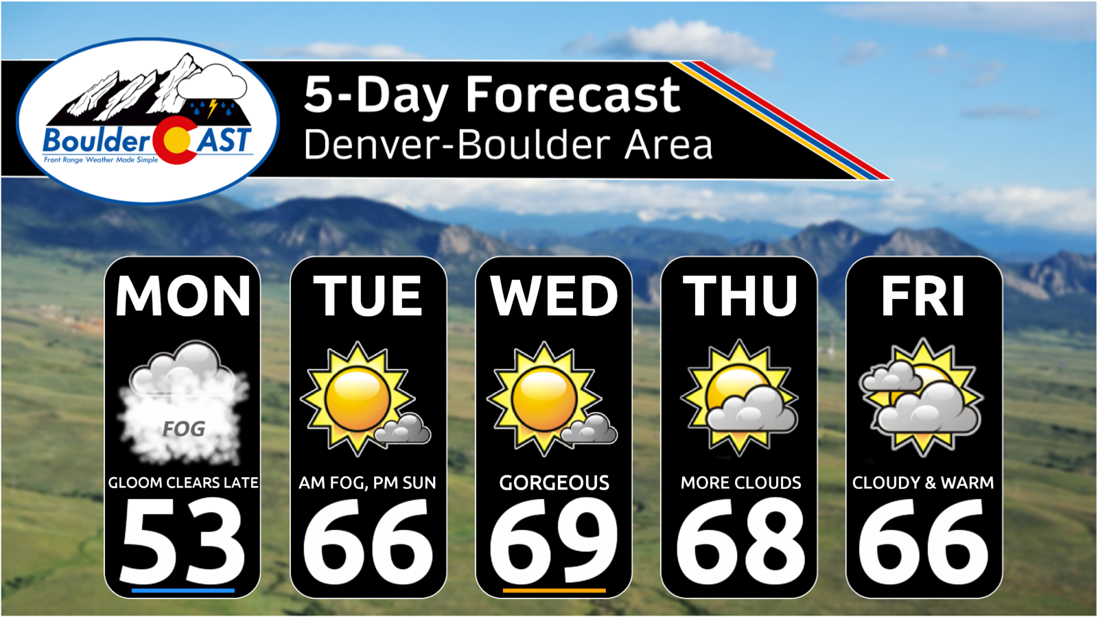
- ☁️ Monday’s Autumn Vibes Are Locked In — Rain exits this morning, but stubborn upslope flow keeps clouds, fog, and a chilly feel hanging around into the afternoon. Highs may struggle to reach the lower 50s.
- 🌤️ Warm-Up Begins Tuesday — After Monday’s cool-down, temperatures rebound steadily through the week, with many areas climbing back into the 60s and even low 70s by late week.
- 🍂 A Classic Front Range Fall Stretch — Sunshine, mild afternoons, and cool nights dominate the forecast, with patchy frost some mornings and no significant weather interruptions through Friday.
- 🎃 Halloween Looking Friendly… For Now — Current trends favor a dry Halloween with seasonable temperatures, though attention is already shifting to a potentially more interesting weather setup beyond the weekend.
- 👀 Next Week’s Storm Bears Watching — Forecast models continue hinting at a stronger trough moving into the West early next week, offering what could be the next meaningful shot at rain, and perhaps even a touch of the white stuff if colder air can tag along.
DISCLAIMER: This weekly outlook forecast is created Monday morning and covers the entire upcoming week. Accuracy will decrease as the week progresses as this post is NOT updated. To receive daily updated forecasts from our team, among many other perks, subscribe to BoulderCAST Premium.

Go Premium, get all the perks.
Daily Forecast Updates
Get our daily forecast discussion every morning delivered to your inbox.
All Our Model Data
Access to all our Colorado-centric high-resolution weather model graphics. Seriously — every one!
Ski & Hiking Forecasts
6-day forecasts for all the Colorado ski resorts, plus more than 120 hiking trails, including every 14er.
Smoke Forecasts
Wildfire smoke concentration predictions up to 72 hours into the future.
Exclusive Content
Weekend outlooks every Thursday, bonus storm updates, historical data and much more!
No Advertisements
Enjoy ad-free viewing on the entire site.
A Gloomy Monday Despite Rain Ending Around Sunrise
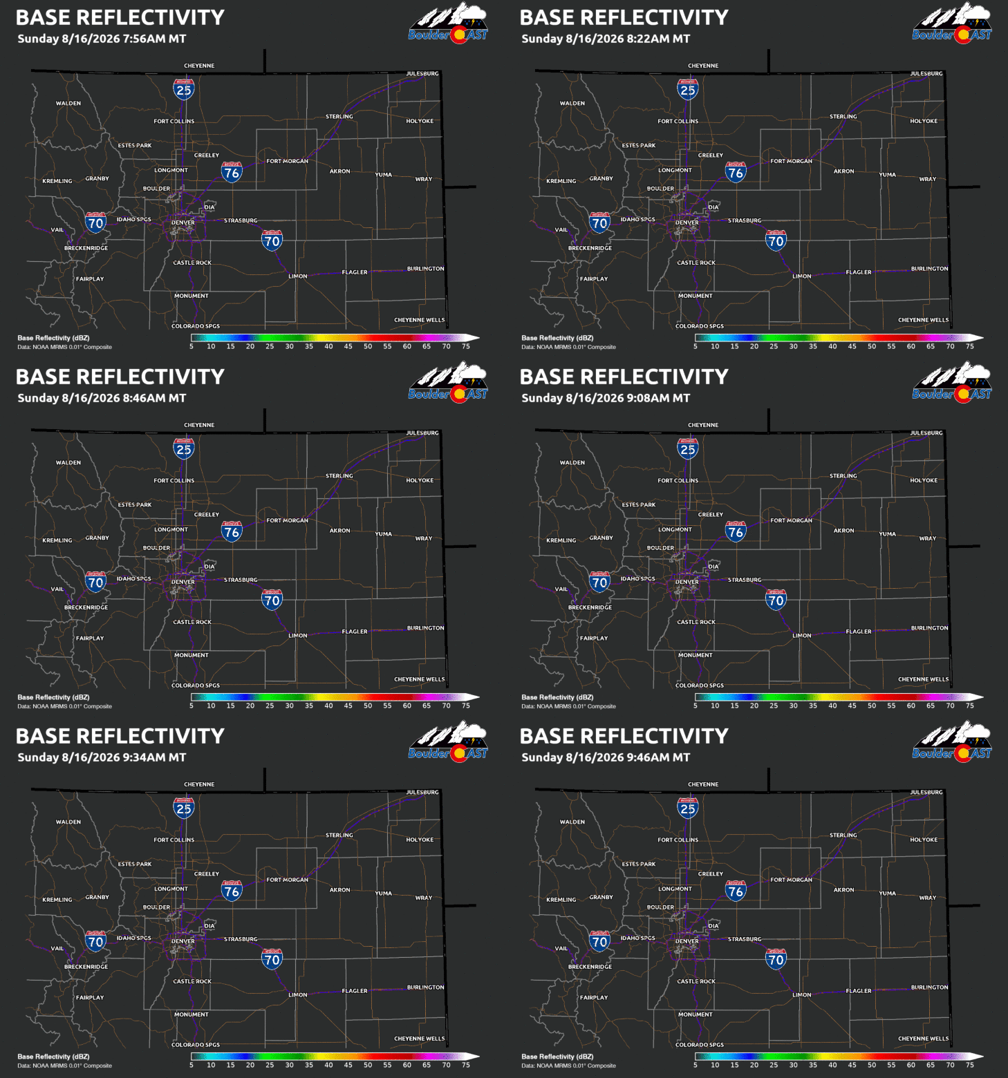
It was a welcome sight to wake up to widespread precipitation across the Front Range overnight and early Monday morning. A weak shortwave disturbance lifting northward out of the Southwest provided the forcing needed for several hours of steady light rain, and much of the Denver Metro area, Boulder County, and surrounding communities ended up seeing 4 to 6 hours of precipitation. This was always expected to be the most favorable window for rain associated with the broader troughy pattern entrenched across the western United States, but the event ended up outperforming expectations in several locations. For a region that has spent much of the month looking for meaningful moisture opportunities, we’ll gladly take an overachiever.
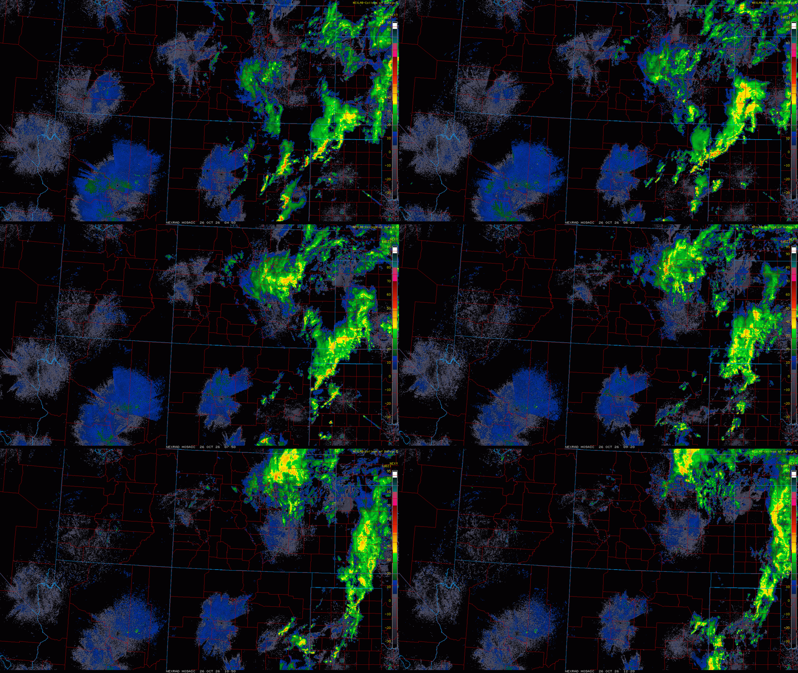
Radar animation from Sunday night into Monday morning showing widespread light rain across the Front Range and Denver Metro area.
Early Monday rainfall reports indicate most locations picked up between one quarter and one half inch of rain, with a few pockets likely seeing locally higher totals. That’s a healthy addition to what has already been a wetter-than-normal October for much of the Front Range. While this won’t do much to erase our longer-term moisture deficits, it provided a beneficial light soaking for lawns, landscapes, and our bone-dry surface soils.
The final batches of light rain will wind down through the early morning hours as the surface low responsible for the event lifts into Nebraska and the northern Plains. Rain should steadily diminish from southwest to northeast, with most locations dry by mid morning. Additional rainfall after this forecast is published should be minimal.
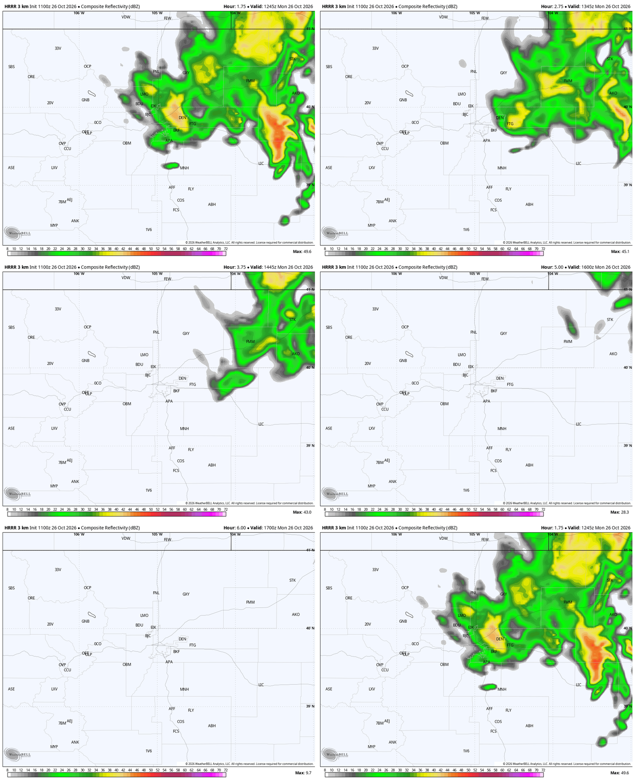
HRRR simulated radar showing precipitation ending from southwest to northeast through Monday morning.
Even after the rain ends, Monday will not be a quick transition back to sunshine. Northeasterly upslope flow behind the departing low will remain firmly in place through much of the day. That means low clouds, areas of fog, and a lingering damp feel will be slow to erode. In fact, the low-level moisture trapped against the Front Range may prove more stubborn than some model guidance suggests.
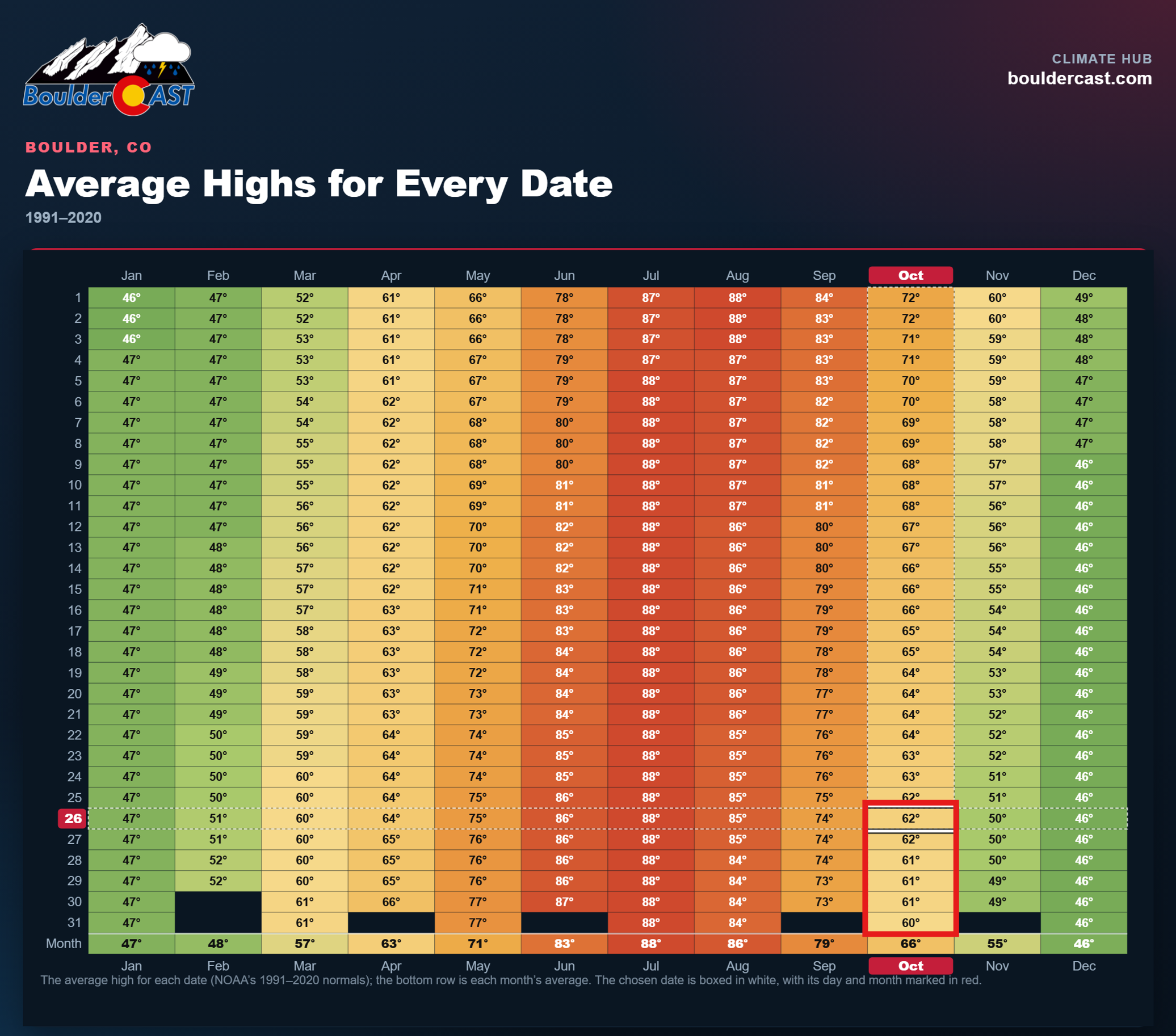
As a result, temperatures will struggle. Afternoon highs are expected to top out only in the upper 40s to middle 50s across the Urban Corridor and adjacent plains, making today the coolest day of the upcoming work week. It will certainly feel like late October, especially compared to the much warmer conditions that lie ahead.
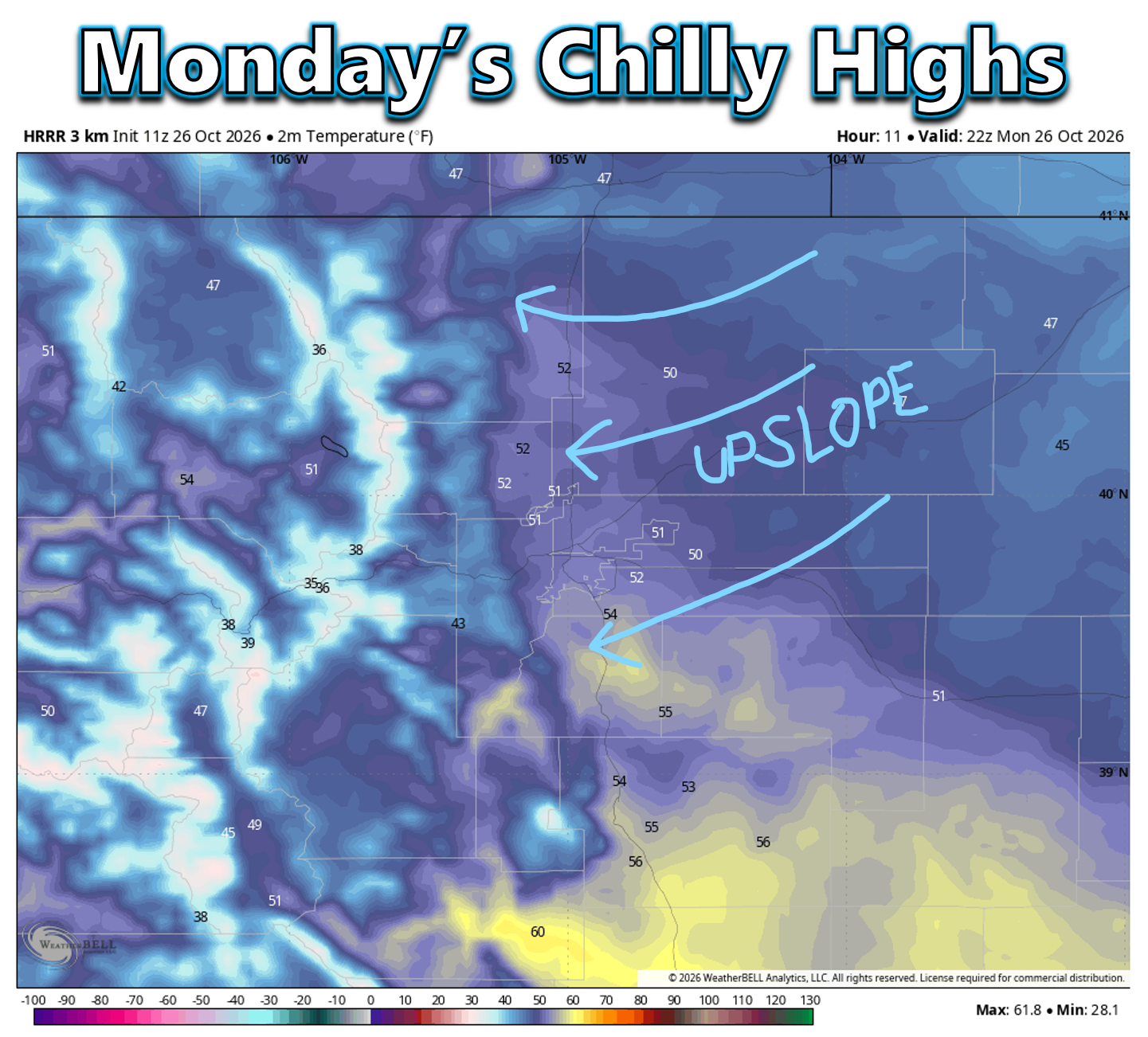
There remains some uncertainty regarding how much sunshine ultimately breaks through later this afternoon. If clouds linger longer, temperatures could end up a few degrees cooler than forecast. Either way, highs will finish several degrees below climatological averages, which typically sit in the lower 60s during the final full week of October.
Drier and Warmer Weather Takes Over Tuesday
Once we get beyond today’s departing storm system, the weather pattern shifts into a much quieter mode. From Tuesday through Friday, the upper-level flow transitions from generally westerly to west-southwesterly as several weak disturbances pass well north of Colorado. At the same time, ridging gradually strengthens across the southern Plains and Southwest. The net result will be a stretch of dry weather accompanied by a noteworthy warming trend.
The ECMWF ensemble temperature guidance paints a fairly consistent signal. Monday ends up being the cold outlier of the week, with temperatures steadily climbing thereafter. By midweek and late week, highs should run roughly 5 to 10 degrees above seasonal averages, with many lower-elevation communities reaching the middle 60s to lower 70s during the afternoon hours.
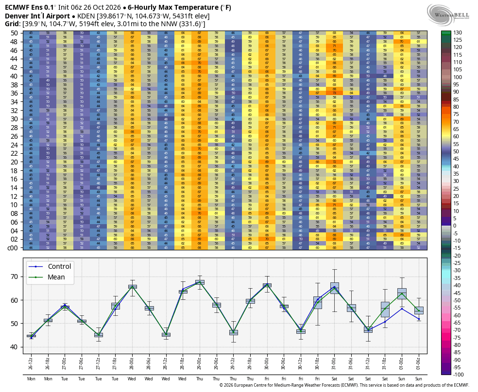
Overnight temperatures will remain relatively mild as well. Lows are generally expected to stay in the upper 30s to lower 40s through the week, which should largely eliminate any meaningful frost or freeze concerns for the lower elevations. Outlying areas could see patchy frost, but that’s about it.
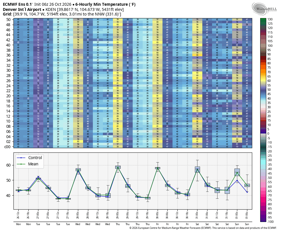
Overall, it’s a classic Front Range autumn setup this week. Plenty of sunshine, mild afternoons, cool nights, and generally tranquil weather conditions. Of course, after seeing how beneficial this latest rain event was, many would gladly trade a few of those warm afternoons for another round of widespread moisture.
Watching the Halloween Weekend Forecast
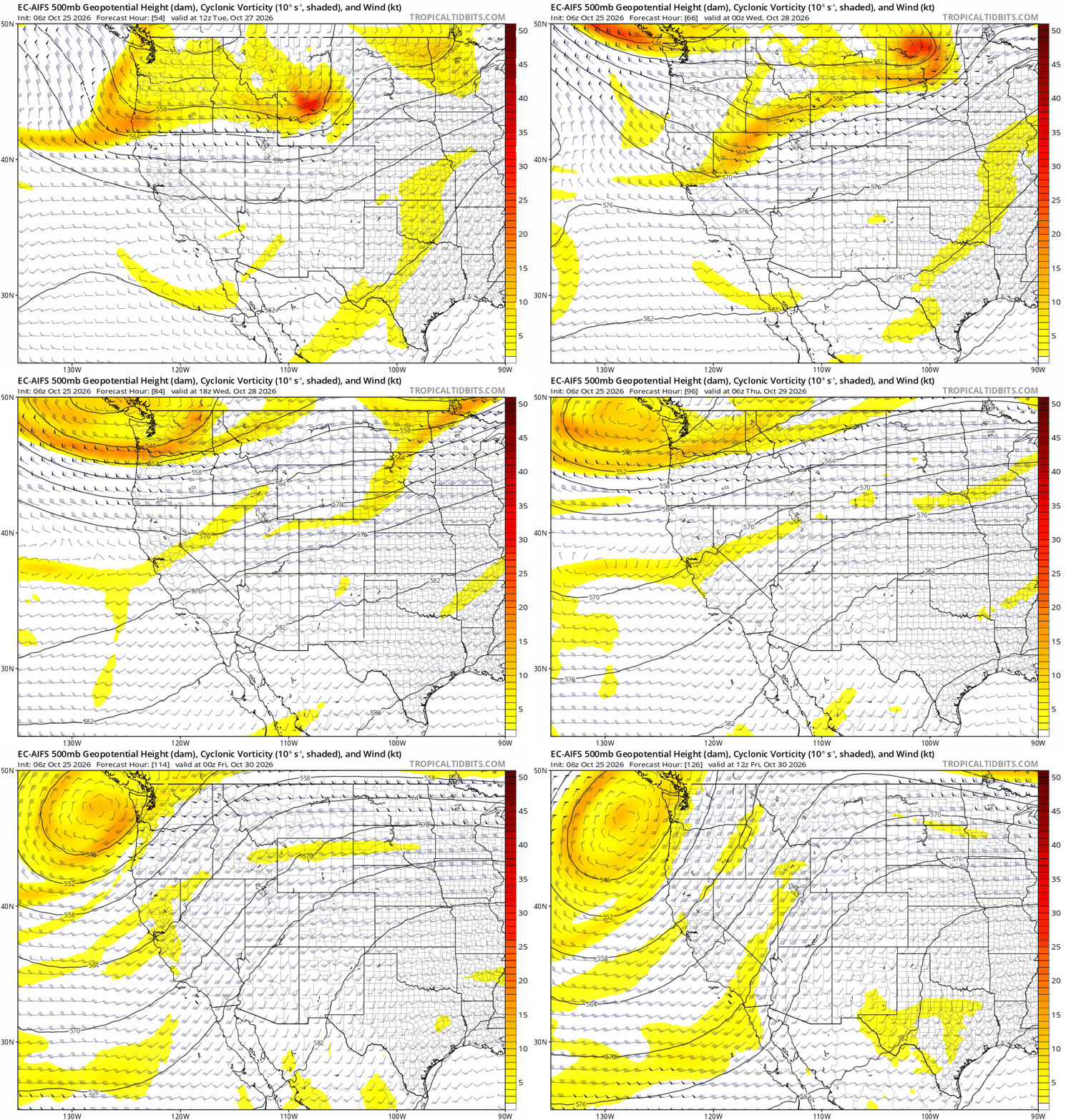
After this morning’s rain exits, the remainder of the week looks dry. Attention then turns toward Halloween weekend and the beginning of next week, where ensemble guidance has become increasingly interested in another potential storm system moving into the western United States.
At this point, the ECMWF AI ensemble suggests the better opportunity for precipitation may actually arrive after Halloween rather than during it. A few ensemble members bring precipitation into Colorado late Saturday or Sunday, but the more coherent signal centers on early next week. Both the ensemble mean and control solutions indicate increasing precipitation potential during the Monday-Tuesday timeframe.
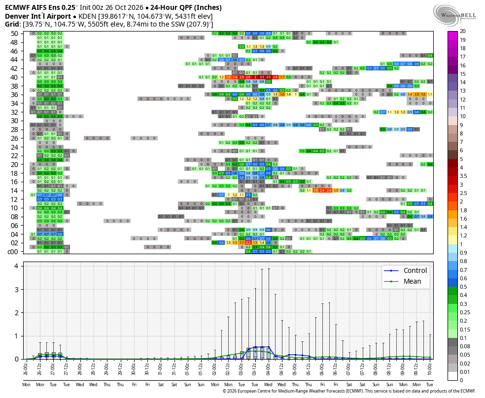
As always, details this far out remain highly uncertain. The overarching signal comes from a potentially stronger trough forecast to move ashore along the West Coast late this weekend before digging toward the Four Corners early next week. If that evolution occurs, it could provide our next legitimate opportunity for widespread precipitation across Colorado.
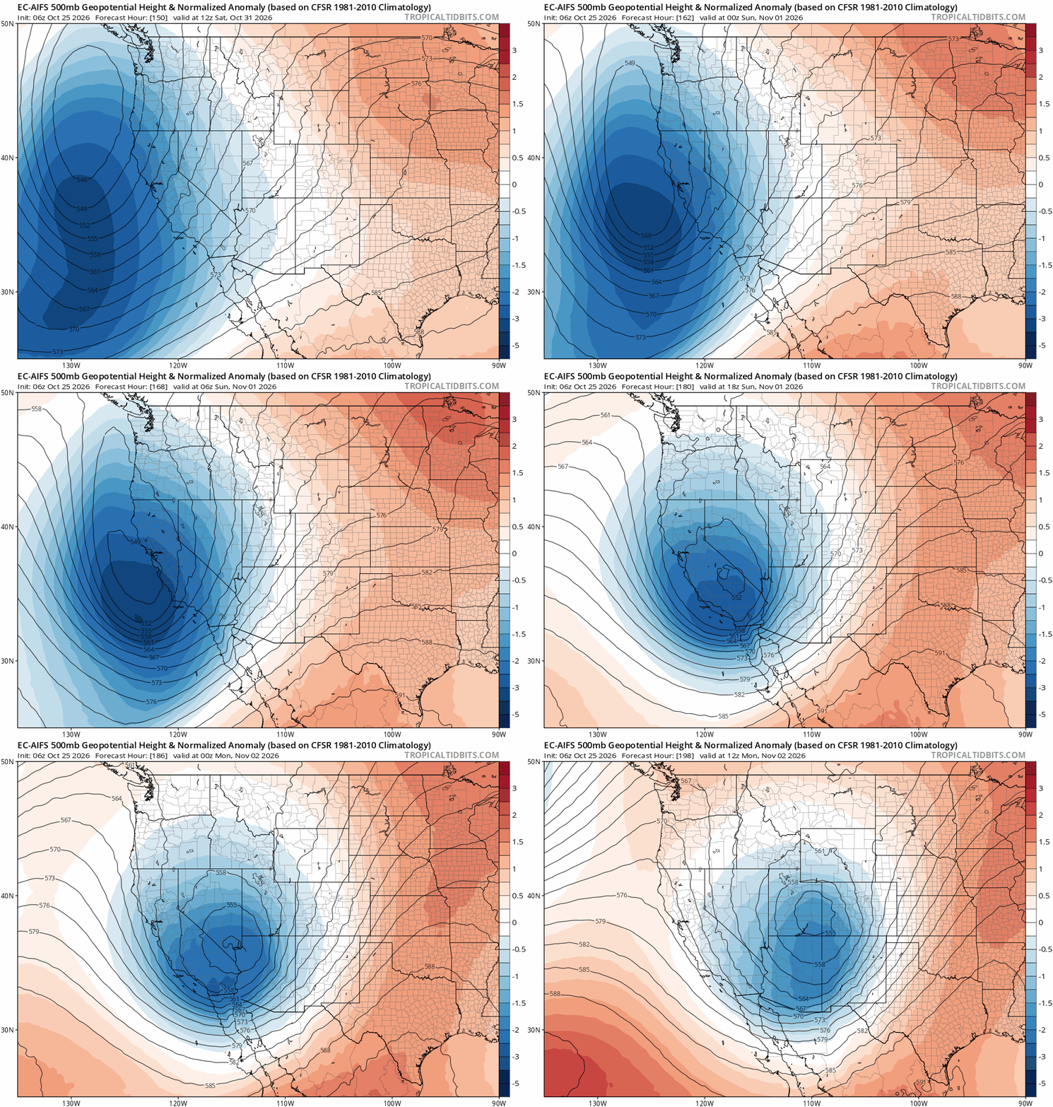
Some ensemble members are cold enough to introduce snow into the equation, at least for portions of the Front Range and Foothills. However, confidence in the thermal profile remains extremely low at this range, making any discussion of precipitation type largely speculative for now. Our 2026 First Snowfall Contest could come to an end in the first days of November, or not. Time will tell!
For Halloween itself, current trends lean toward a mainly dry forecast. That would be welcome news for trick-or-treaters. Temperatures presently look fairly seasonable, with afternoon highs in the lower 60s with evening readings falling through the 40s as festivities get underway.
Tropical Moisture Still Active to Our South
One other feature worth keeping an eye on is the continued activity across the eastern Pacific. Tropical Storm Vance is the latest named system and is currently located well south of Mexico. Forecast guidance weakens Vance through the week as it drifts northward, eventually supplying another plume of tropical moisture into portions of the American Southwest. For Colorado, the impacts appear limited. However, some of that higher-level moisture may spread into the region by Friday, leading to an increase in cloud cover. Temperatures could be trimmed back slightly as a result, but current indications do not support any real precipitation chances along the Front Range.
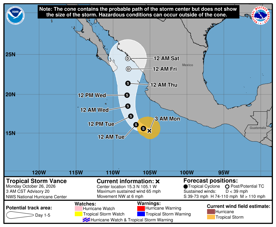
With the exception of today’s cool and cloudy weather, the extended forecast looks quiet, calm, and relatively warm by late October standards. After a much-needed rain event and a true taste of autumn today, we’re headed into a stretch of pleasant fall weather before turning our attention to what could be the next storm opportunity early next week.
Enjoy the final days of October, and have a safe and enjoyable Halloween. 🎃

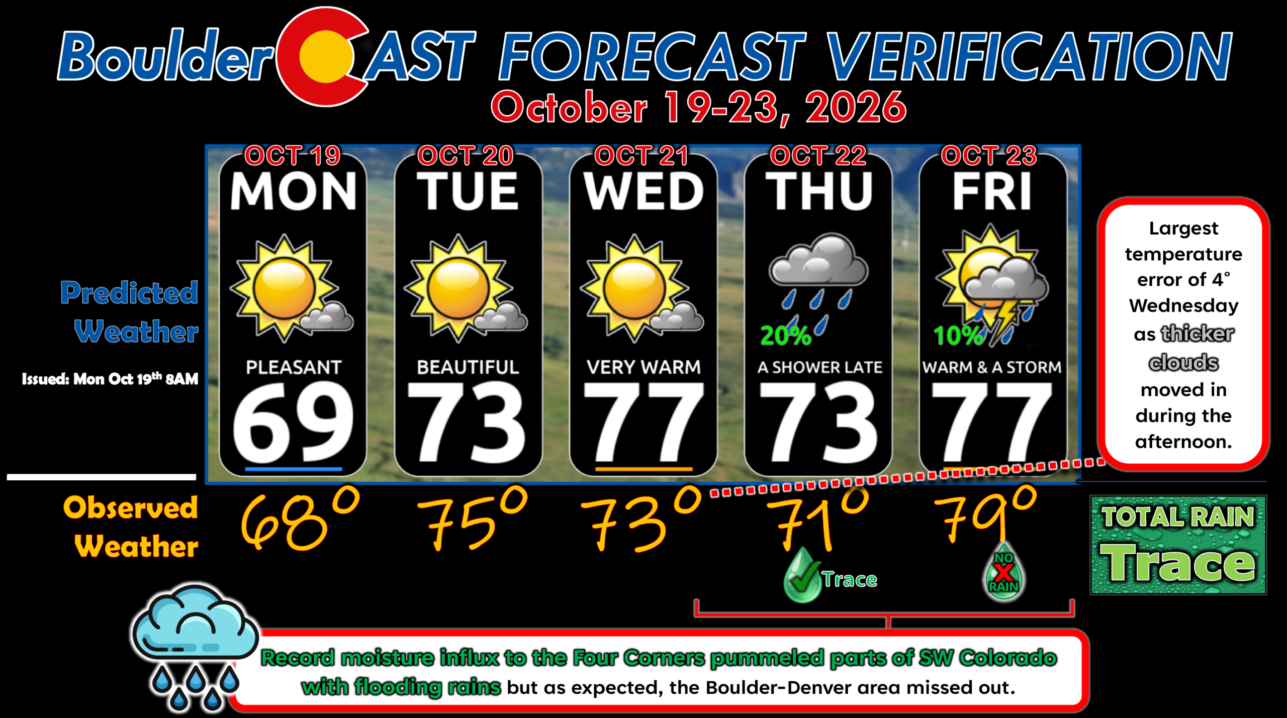
Forecast Verification: October 19-23, 2026 (Last Week)
- Surge of tropical moisture pummeled SW Colorado with heavy rains, but Boulder-Denver missed out, recording just a trace of rain late in the week.
- Largest temperature error was 4° on Wednesday as thicker-than-expected clouds moved in during the afternoon hours, capping temperatures.
- Less than 2° of error every other day.
DISCLAIMER: This weekly outlook forecast is created Monday morning and covers the entire upcoming week. Accuracy will decrease as the week progresses as this post is NOT updated. To receive daily updated forecasts from our team, among many other perks, subscribe to BoulderCAST Premium.
Go Premium, get all the perks.
Daily Forecast Updates
Get our daily forecast discussion every morning delivered to your inbox.
All Our Model Data
Access to all our Colorado-centric high-resolution weather model graphics. Seriously — every one!
Ski & Hiking Forecasts
6-day forecasts for all the Colorado ski resorts, plus more than 120 hiking trails, including every 14er.
Smoke Forecasts
Wildfire smoke concentration predictions up to 84 hours into the future.
Exclusive Content
Weekend outlooks every Thursday, bonus storm updates, historical data and much more!
No Advertisements
Enjoy ad-free viewing on the entire site.
Enjoy our content? Give it a share!






Leave a Reply
You must be logged in to post a comment.