


With November half gone, we’ve rolled our official winter outlook forward to cover December through April. It now uses the newest November 1st runs from all 10 major seasonal models, which reach into April for the first time. The headline from our last update post holds, and it may have gotten a little stronger: the odds favor a wetter-than-normal winter and spring for most of Colorado, especially east of the mountains.
F
irst, let’s check-in on El Niño. It is still strengthening. NOAA’s November 12 update put October’s Niño-3.4 sea surface temperatures at +2.5 °C above normal, up from +2.1 °C in September. NOAA still gives a strong-to-very-strong event better than 79% odds of lasting through January–March. The chance this becomes the strongest El Niño since 1950 eased a bit, from 70–83% last month to about 60%, but that’s still substantial. The European model now has the peak of the event in January, with weakening expected throughout early 2027.
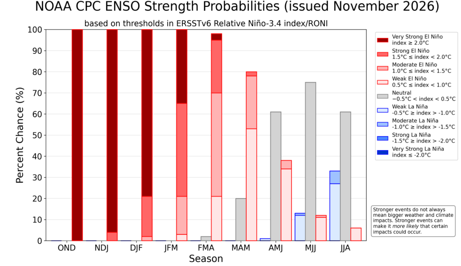
Outside of the record-breaking rainstorm we had in mid-October, it’s been a slow start to the water year in the Front Range. That’s no surprise, though. A lag in El Niño’s actual global weather influence is typical. Its impact on the jet stream usually lingers into March and April, well after the ocean has started to cool, so there is still plenty of time to play catch-up.
Our Official Updated Seasonal Forecast
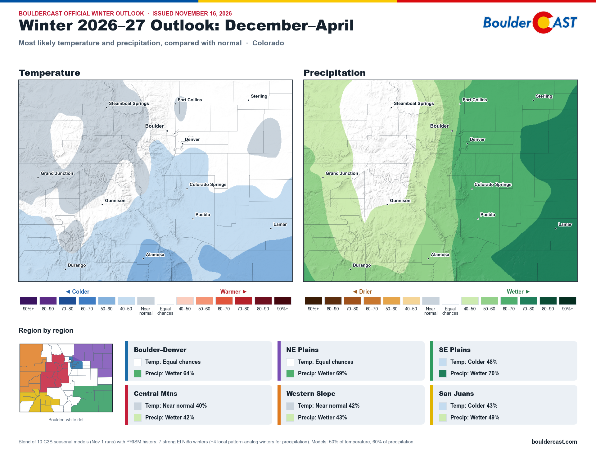
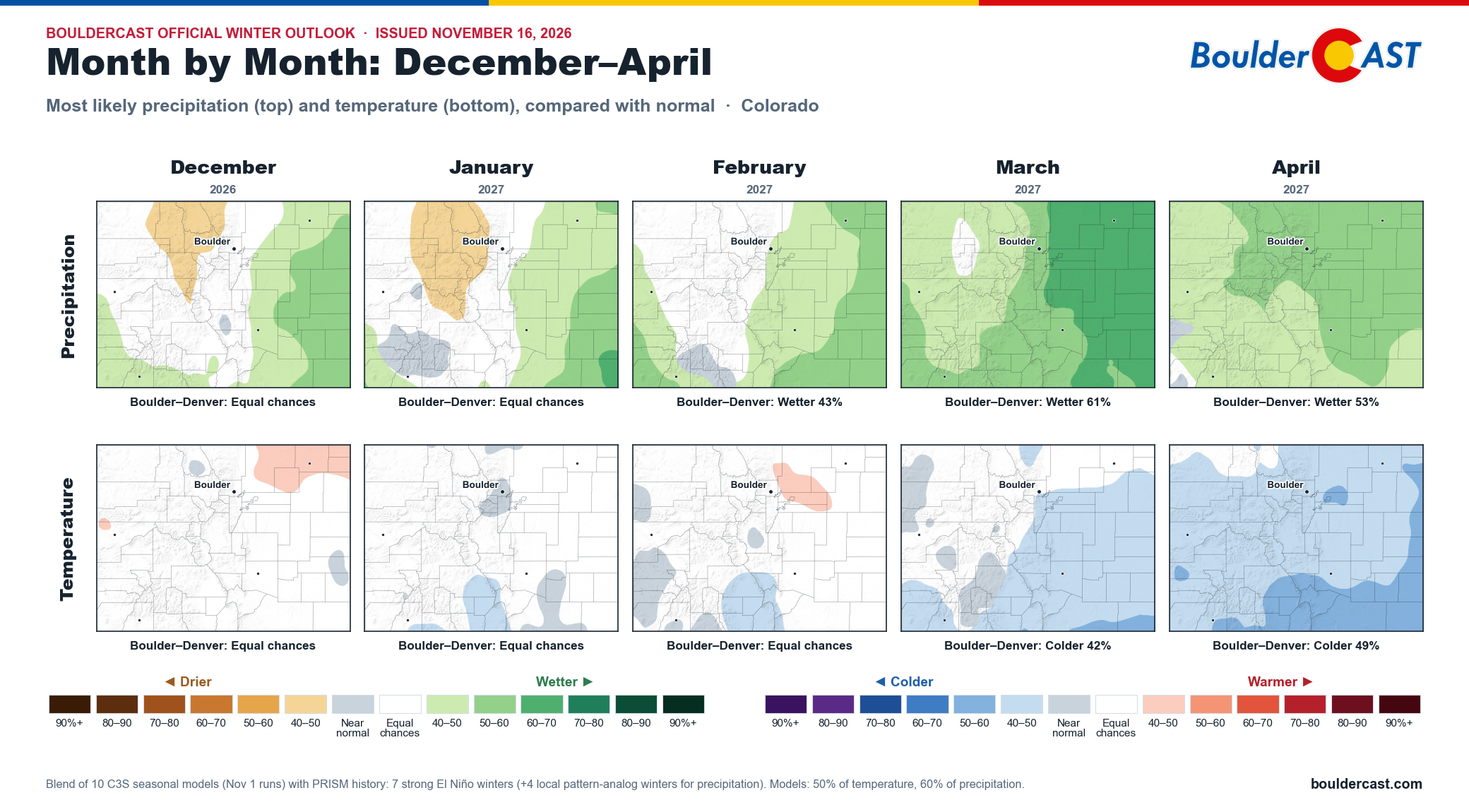
BoulderCAST official outlook for Colorado, December 2026–April 2027: most likely temperature and precipitation
Compared with our last update, which covered November–March using the October model runs, the picture is broadly the same with a few notable shifts. Part of that comes from the newer model runs, and part from swapping November for April, a month that leans wet in this El Niño.
- Boulder–Denver: wetter odds tick up to 64%, from 61%.
- Plains: still our most confident call, at 68% wetter on both the northeast and southeast plains.
- Mountains: the Central Mountains and Western Slope flip from equal chances to a modest wet lean (41–43%), as a wetter spring now outweighs the drier-leaning midwinter we flagged before. The San Juans stay wet-leaning at 46%.
- Temperatures: a weak signal overall, but southern Colorado has turned slightly cooler: colder 48% on the southeast plains and 43% in the San Juans. Boulder–Denver remains at equal chances.
The timing shows up clearly when we break the 10 models down month by month:
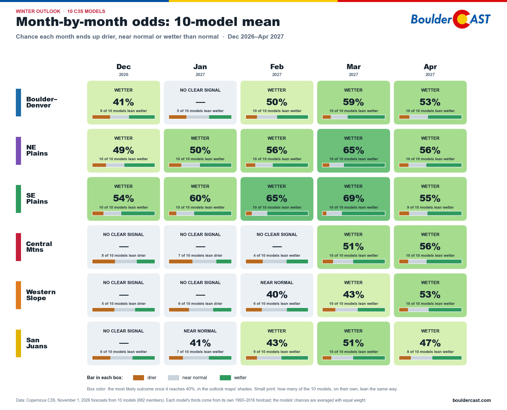
On the plains, the models lean wet in every month, and all 10 agree in nearly every one, peaking at 69% wetter in March on the southeast plains. In the mountains, December and January show no clear signal, and most models actually lean slightly dry there early. Then March and April turn wet in every region, with all 10 models agreeing. For Boulder–Denver, January is a coin flip, but February through April all lean wet.
Our official blend tells the same story: the wet signal is weakest in December and January and builds through March (62% wetter for Boulder–Denver) and April (53%). That’s right when our biggest upslope snowstorms tend to happen.
Here’s how things look Westwide through April and where Colorado fits in:
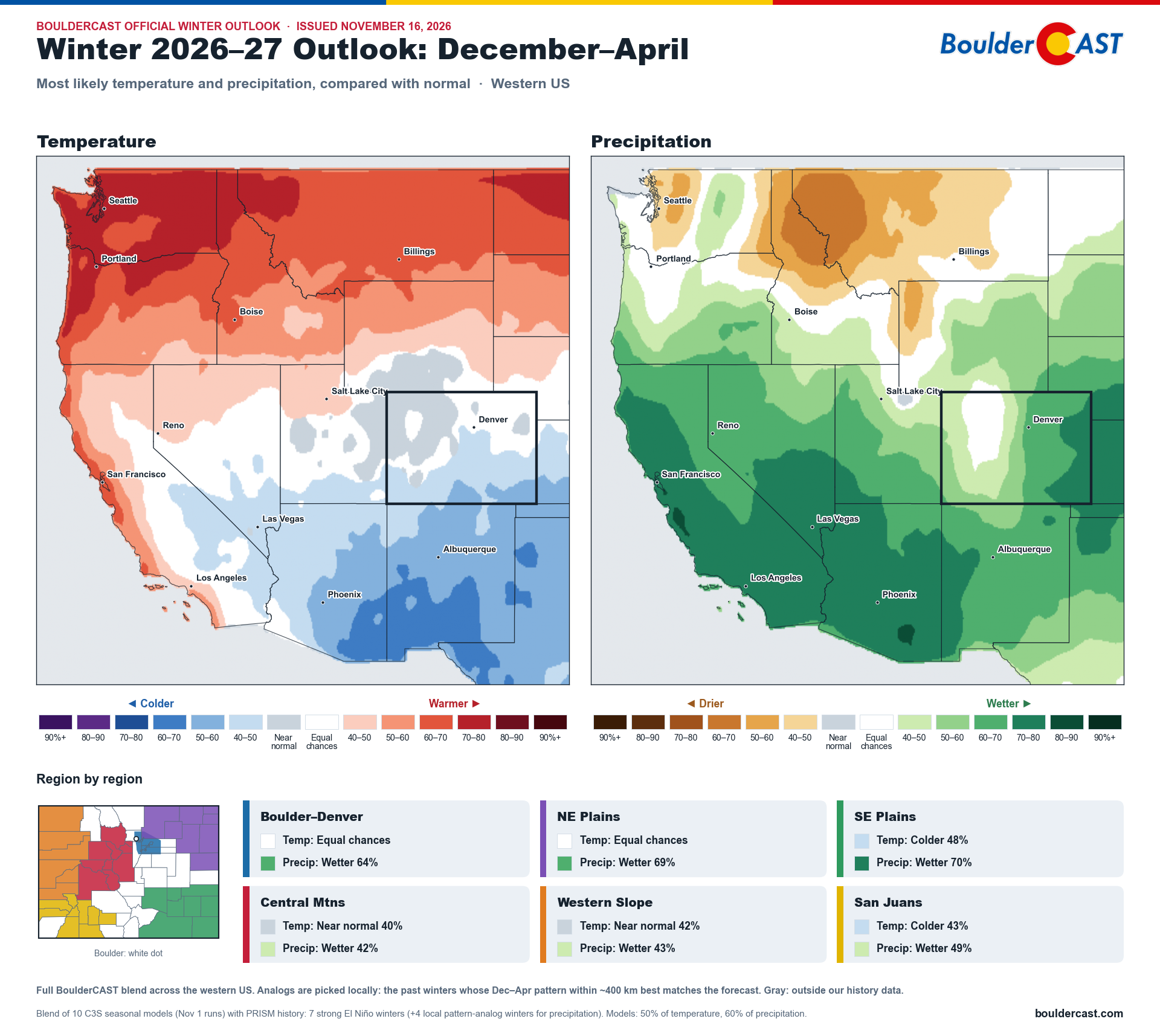
BoulderCAST official outlook for the American West, December 2026–April 2027: most likely temperature and precipitation
Strong El Niño winters have historically been feast or famine for Boulder’s snow, and spring is usually what tips the balance. Our latest update leans toward feast, but it’s backloaded with a bigger reliance on a distant spring delivering than we’d like.
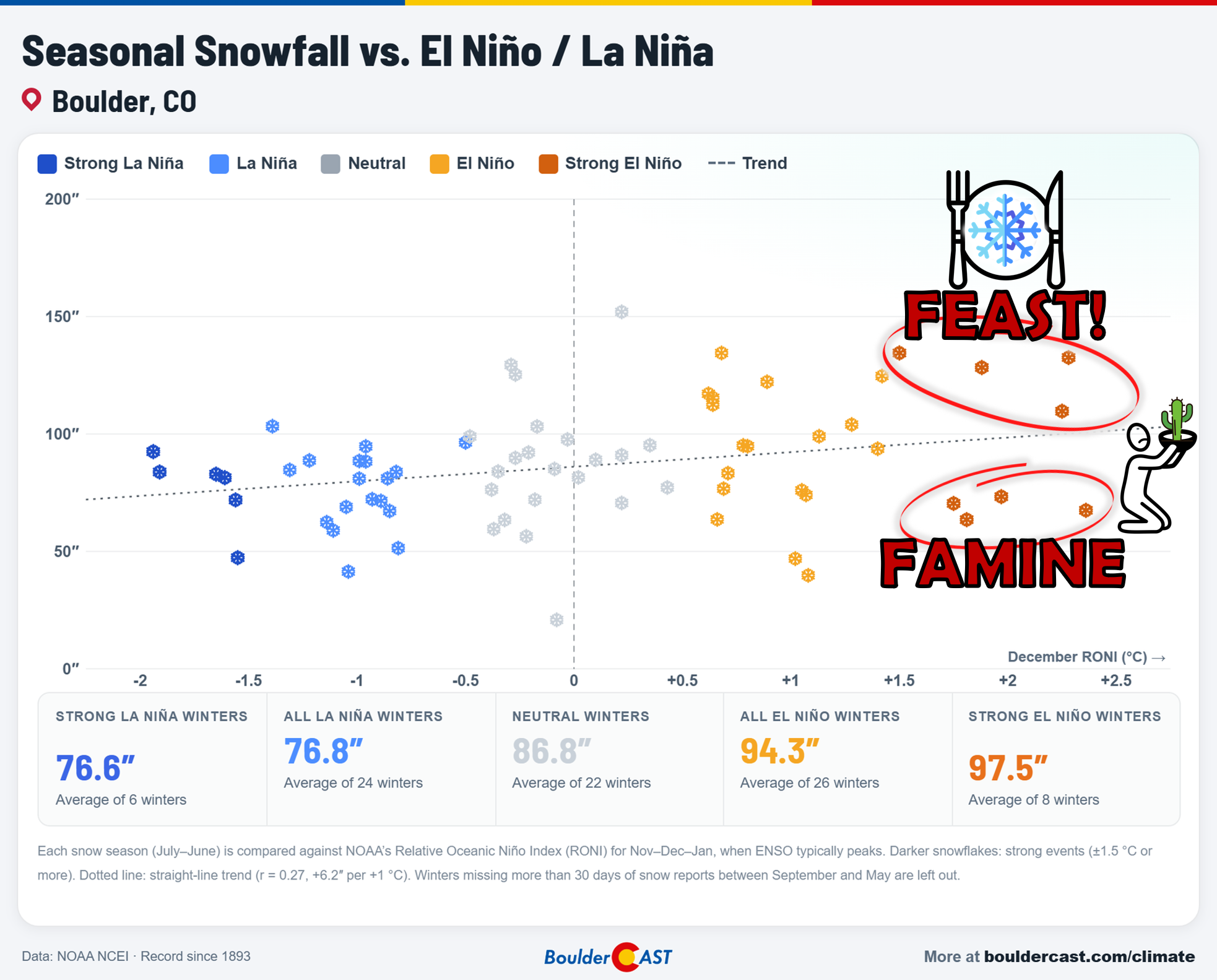
Want to dig deeper? Every El Niño chart in this post, and many more, lives in the El Niño & La Niña section of our Colorado Climate Hub.
Spread the word, share our crazy Colorado weather:

Go Premium, get all the perks.
Daily Forecast Updates
Get our daily forecast discussion every morning delivered to your inbox.
All Our Model Data
Access to all our Colorado-centric high-resolution weather model graphics. Seriously — every one!
Ski & Hiking Forecasts
6-day forecasts for all the Colorado ski resorts, plus more than 120 hiking trails, including every 14er.
Smoke Forecasts
Wildfire smoke concentration predictions up to 84 hours into the future.
Exclusive Content
Weekend outlooks every Thursday, bonus storm updates, historical data and much more!
No Advertisements
Enjoy ad-free viewing on the entire site.




Leave a Reply
You must be logged in to post a comment.