


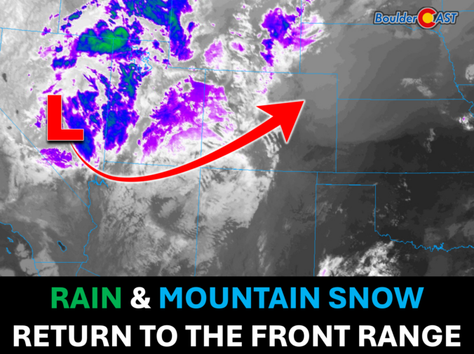
After months of watching drought deepen across the Front Range, Colorado is finally getting a storm that could turn the tide. A slow-moving upper low will tap into an unusually rich plume of subtropical moisture and bring widespread rain to much of northern Colorado, along with the season’s first meaningful Mountain snowfall. How much rain can Boulder and Denver expect, who stands the best chance of topping an inch, how low will snow levels drop during the event and which night will bring the season’s first freeze? We break down the latest forecast, timing, rainfall totals, and snow prospects.
What You Need to Know
- 🌧️ A long-awaited soaking rain: The Front Range’s most widespread precipitation event in months arrives Tuesday night through early Thursday, with steady rain expected for most areas.
- 💧 Much-needed drought relief: After months of growing moisture deficits and expanding drought across northern Colorado, this storm should provide meaningful, though not drought-ending, relief.
- 📍 Boulder favored for the highest totals: Boulder and Larimer Counties have the best chance to pick up 0.75 to 1.25 inches of rain, while Denver will likely see lower but still beneficial amounts.
- 🏔️ First significant Mountain snow of the season: Expect 6 to 10 inches above treeline, with locally higher amounts and winter travel impacts on major Mountain passes.
- 🥶 End of the growing season: Post-storm, frost and/or a light freeze is expected Thursday and Friday nights. Begin your preparations!
- ✅ Bottom line: Deep subtropical moisture, long-lasting upslope flow, and a slow-moving storm system should combine to produce the wettest days many Front Range communities have experienced since May.

Go Premium, get all the perks.
Daily Forecast Updates
Get our daily forecast discussion every morning delivered to your inbox.
All Our Model Data
Access to all our Colorado-centric high-resolution weather model graphics. Seriously — every one!
Ski & Hiking Forecasts
6-day forecasts for all the Colorado ski resorts, plus more than 120 hiking trails, including every 14er.
Smoke Forecasts
Wildfire smoke concentration predictions up to 84 hours into the future.
Exclusive Content
Weekend outlooks every Thursday, bonus storm updates, historical data and much more!
No Advertisements
Enjoy ad-free viewing on the entire site.
O
ur main weather player this week, a chilly and unusually slow-moving upper-level low, is centered over central Nevada Tuesday morning. Ahead of it, a moderately strong and moisture-rich southwest flow is spreading into the Four Corners region and western Colorado. At the surface, a cold front swept through the Denver Metro area Monday night, producing low clouds, areas of fog and even pockets of drizzle around Boulder by Tuesday morning.
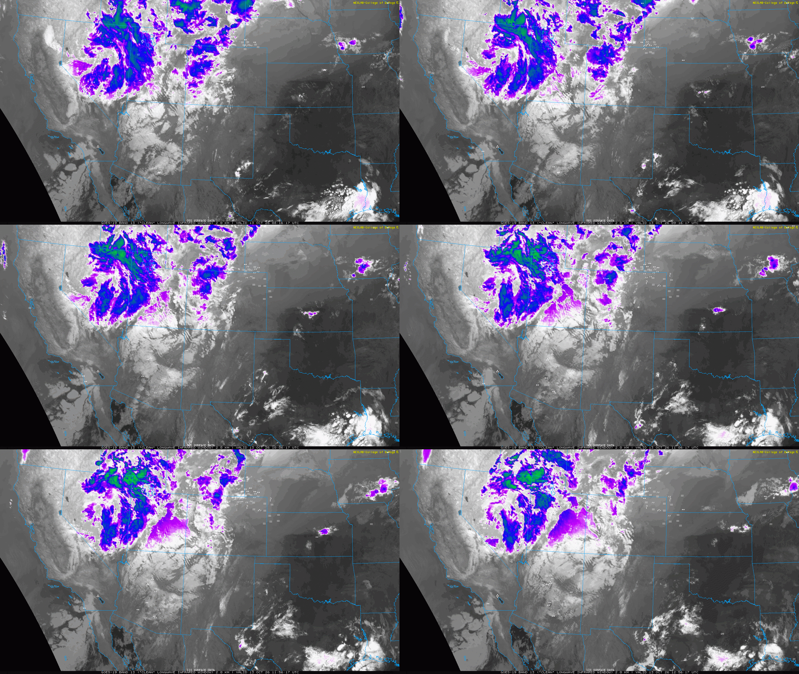
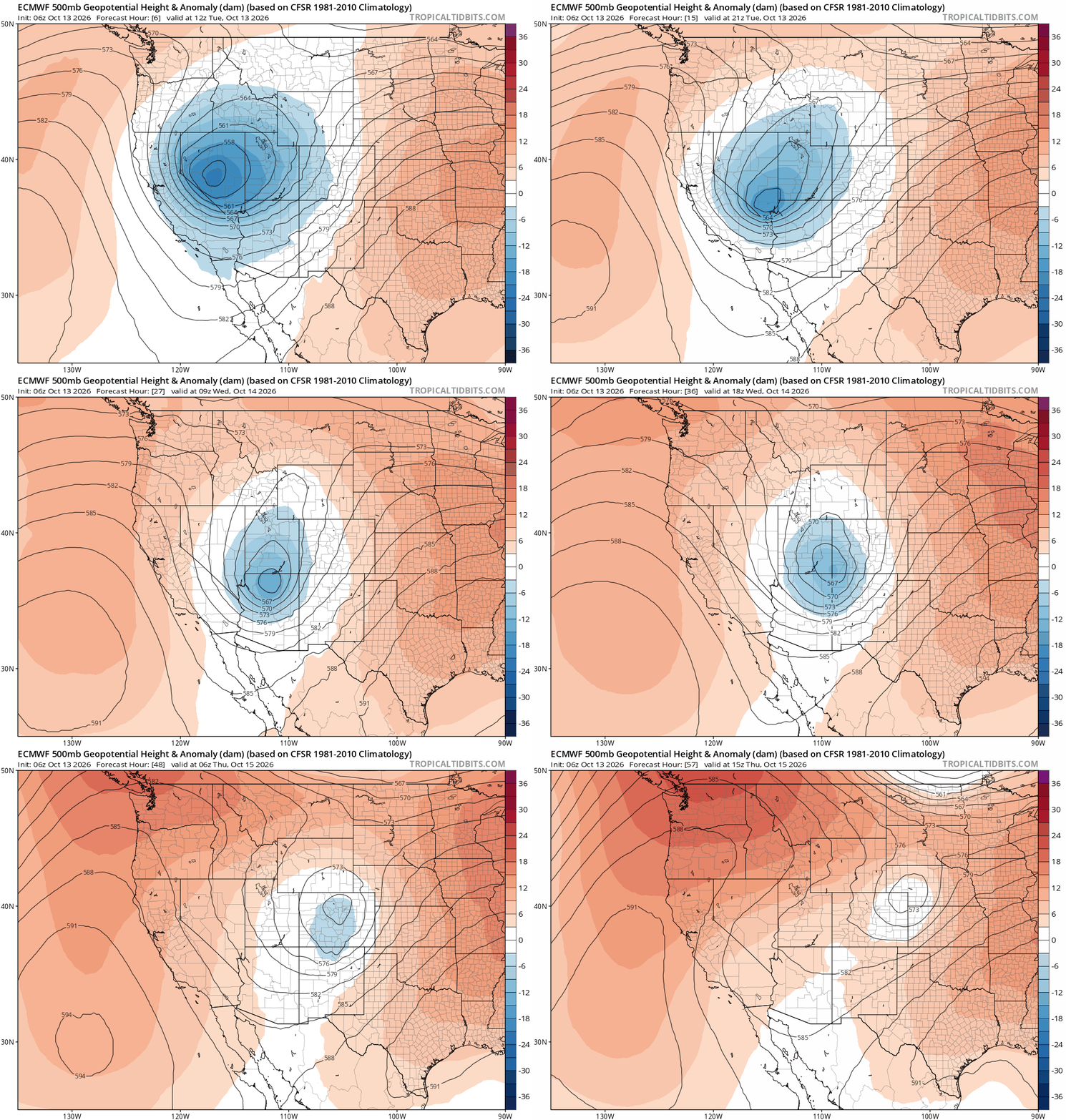
The storm is expected to continue digging south through Tuesday before turning east-northeast toward Colorado Tuesday night. Current guidance takes the center of the low near Las Vegas around sunset Tuesday evening, across the Four Corners region around midday Wednesday and then directly over the Front Range by Thursday morning as it gradually weakens. While recent model trends have nudged the track slightly farther north than ideal, the overall setup remains highly favorable for widespread precipitation.
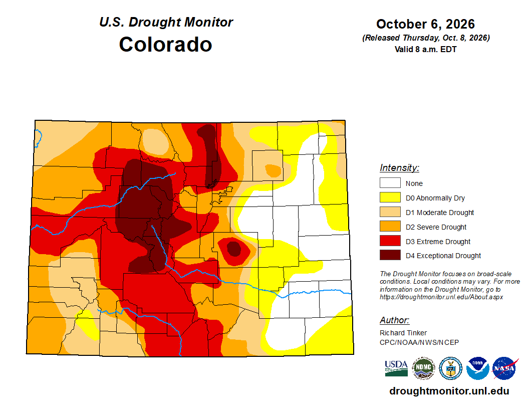
That is welcome news for our state which is deeply entrenched in drought. Recent months have only intensified those concerns, with drought conditions expanding and soils becoming increasingly parched across eastern Boulder and Larimer Counties which were recently upgraded to Exceptional Drought status (D4). This week’s system represents the first opportunity in many months for a widespread, soaking precipitation event capable of providing some drought relief.
Showers and thunderstorms will continue developing across Colorado through Tuesday, but significant precipitation along the Front Range will likely hold off until the low draws closer and easterly upslope flow strengthens Tuesday night through Wednesday night. The low clouds and drizzle blanketing the Denver Metro Area Tuesday morning should gradually thin through midday and afternoon, though it remains unclear just how much sunshine will ultimately break through. Afternoon temperatures will generally range from the upper 50s to middle 60s, with the warmer readings dependent on at least a few periods of sun.
A few showers and perhaps an isolated thunderstorm may develop over portions of the Urban Corridor Tuesday evening. More widespread and persistent precipitation should then expand overnight as large-scale lift, deepening moisture and strengthening upslope flow come together.
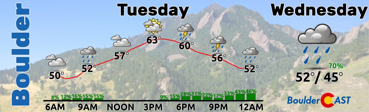
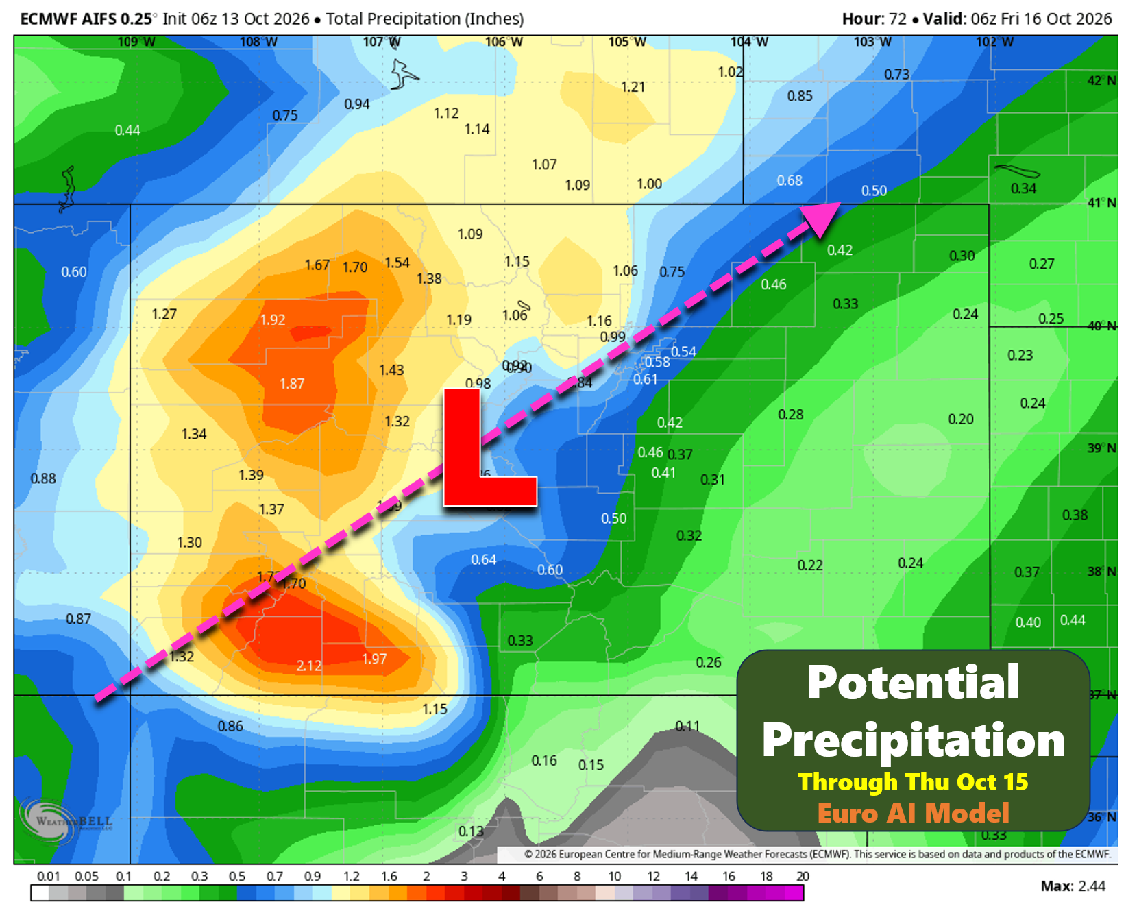
By early Wednesday morning, as the low moves into the Four Corners region, forcing and upslope flow will intensify considerably across the northern Front Range. Widespread light rain is expected through much of Wednesday and Wednesday evening. The anticipated storm track, nearly overhead of Denver, favors the northern Front Range for the highest rainfall totals, especially Larimer County and Boulder County. Farther south and east across the Metro Area, rainfall should become progressively lighter due to subtle downslope influences off the Palmer Divide.
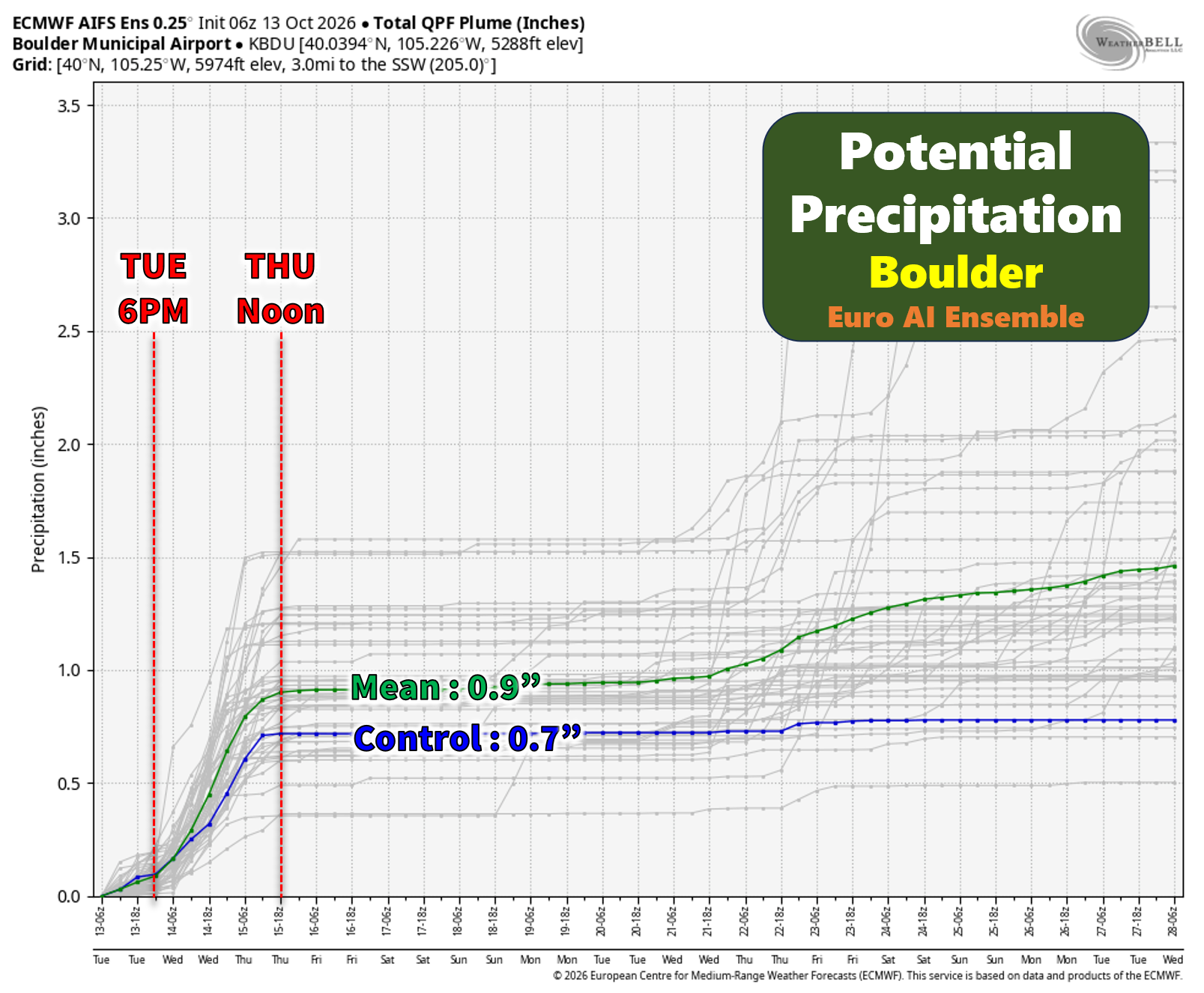
Boulder and Fort Collins remain positioned well for a significant rainfall event. The latest European AI ensemble guidance produces an average of roughly 0.9 inches of rain across Boulder through Thursday morning. Despite the slightly less-than-ideal storm track, only about 5% of ensemble members generate less than one-half inch of rainfall. In other words, confidence is high that the northern Front Range will experience a genuinely beneficial soaking rain.
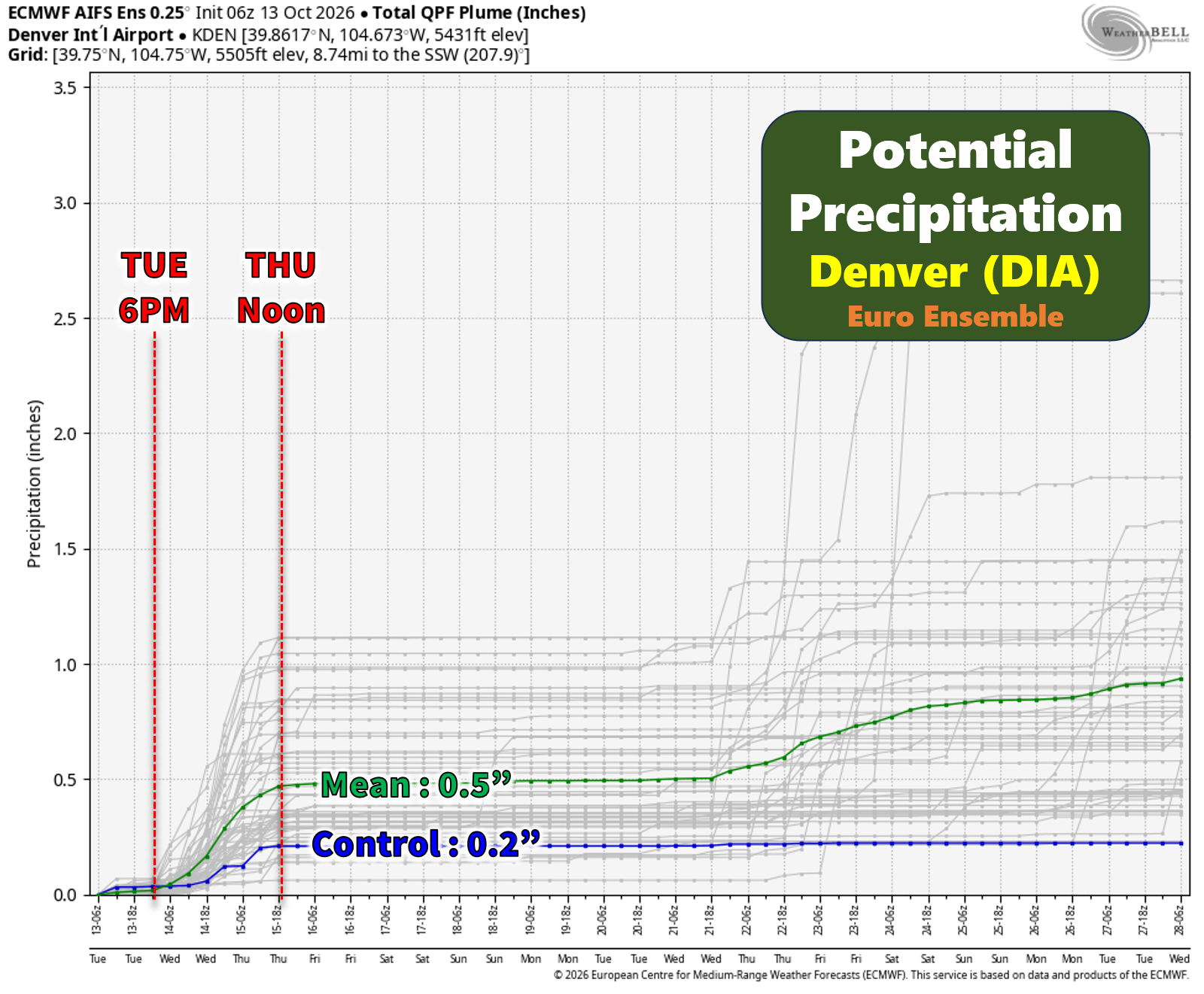
The forecast becomes a little less certain farther south. Denver sits somewhat removed from the terrain and is not as efficiently favored during southeasterly flow regimes. Expected totals average around one-half inch, though outcomes ranging from roughly one-quarter inch to near one inch remain possible, especially near and south of Interstate 70.
A notable aspect of this event is just how much moisture will be available. Atmospheric precipitable water is projected to exceed 200% of normal for much of the storm, creating an environment supportive of efficient rainfall production. Embedded convective elements Tuesday evening and night may further enhance localized rainfall rates, particularly in and near the Foothills of Boulder and Larimer Counties. There is some potential for locally over 2 inches of rainfall in these areas if the Tuesday night convection verifies.
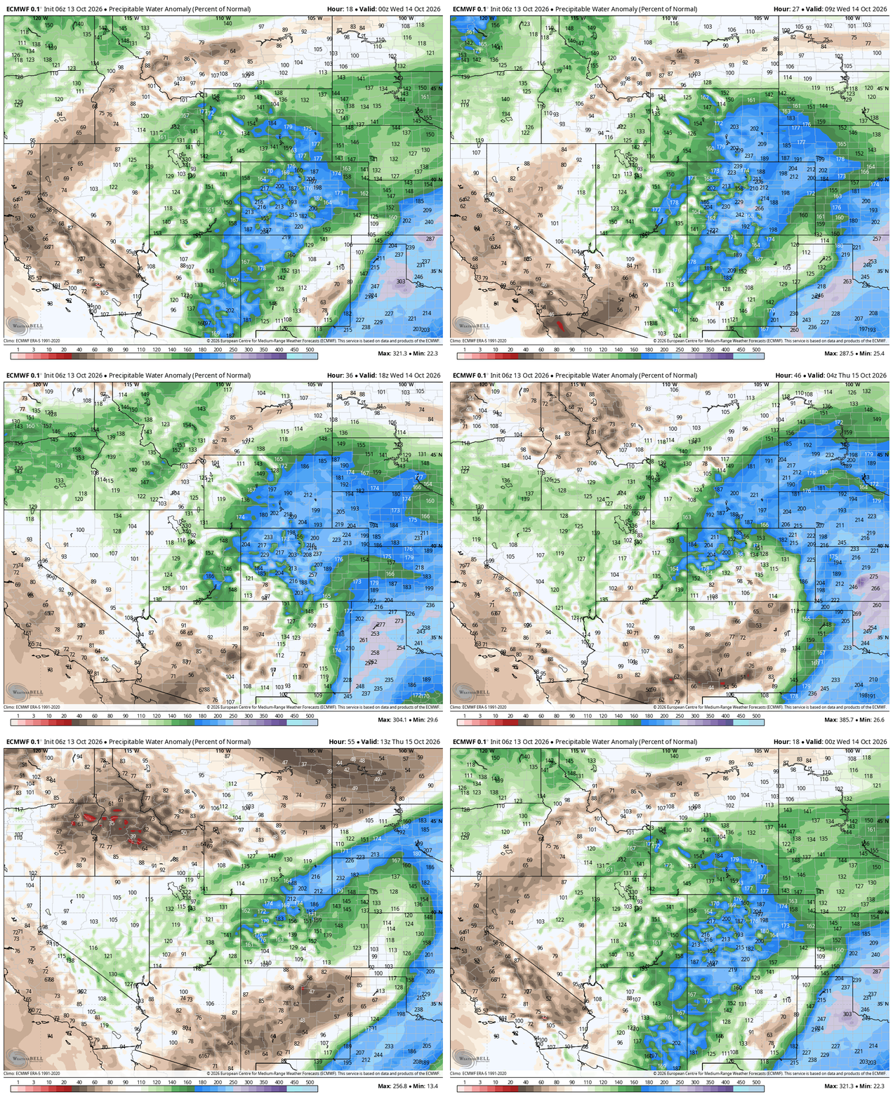
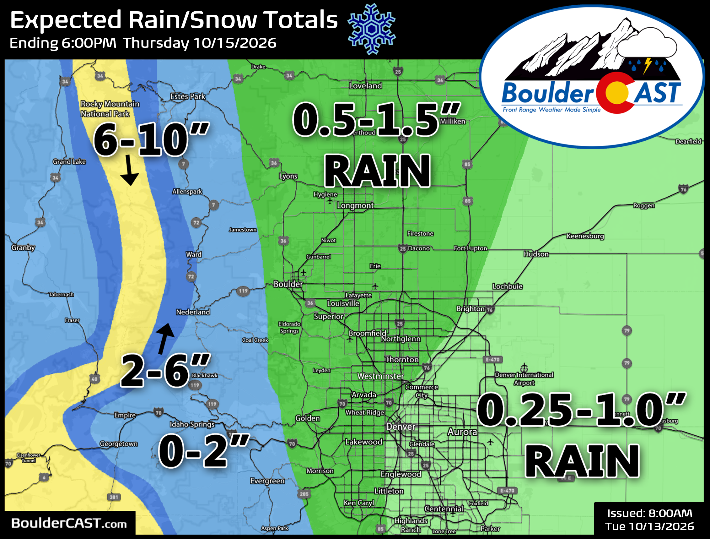
Overall, most locations should see precipitation develop Tuesday evening or overnight, continue throughout Wednesday and persist into Wednesday night. Areas farther northwest, especially Boulder and Larimer Counties, have the best chance of exceeding one inch of rainfall. Farther southeast, rainfall amounts become increasingly uncertain, with some scenarios producing notably lower totals.
As the upper low crosses Colorado, colder air wrapping around the circulation will spread into the state Wednesday and Wednesday night. Snow levels, initially above 12,000 feet Tuesday, should lower to around 9,500 feet Wednesday and potentially fall as low as 7,000 feet Wednesday night into Thursday morning as the system winds down. Some guidance suggests the coldest air arriving late in the event could briefly support snow levels below 7,000 feet, but the timing appears just late enough to prevent any snowfall in Boulder or Denver as the storm exits to the northeast and fizzles out.
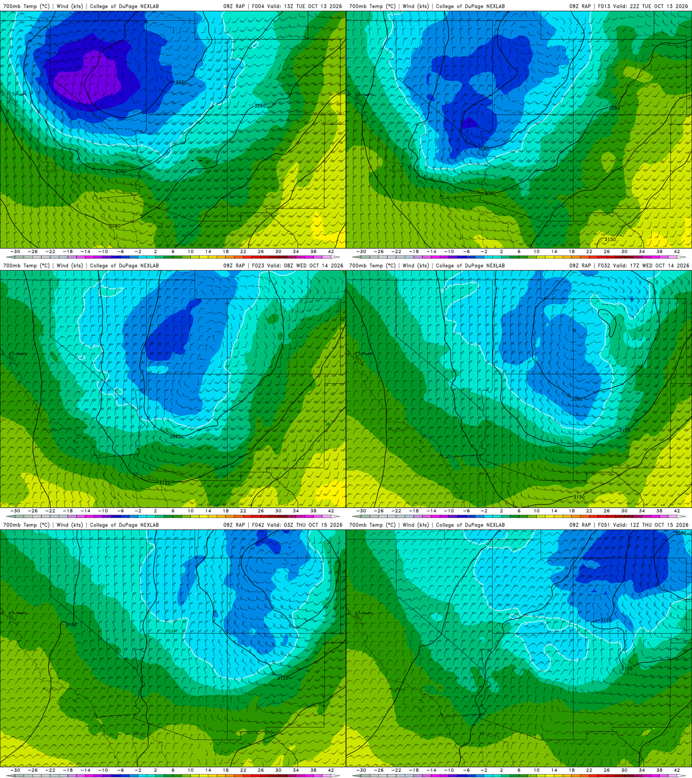
The mountains will see their first widespread snowfall of the season. Amounts of 6 to 10 inches above timberline appear likely, with locally over a foot possible on the highest peaks. Winter driving conditions are expected on several high passes, including Eisenhower Tunnel, Vail Pass, Loveland Pass and Guanella Pass. Trail Ridge Road will likely be impacted significantly and close for the season during or shortly after this event. As snow levels descend Wednesday evening, a couple inches of accumulation may occur in higher Foothills communities such as Ward and Nederland, though locations below roughly 8,000 feet should generally see little more than a wet dusting.
Post Storm Frost and/or Freeze Looks Likely
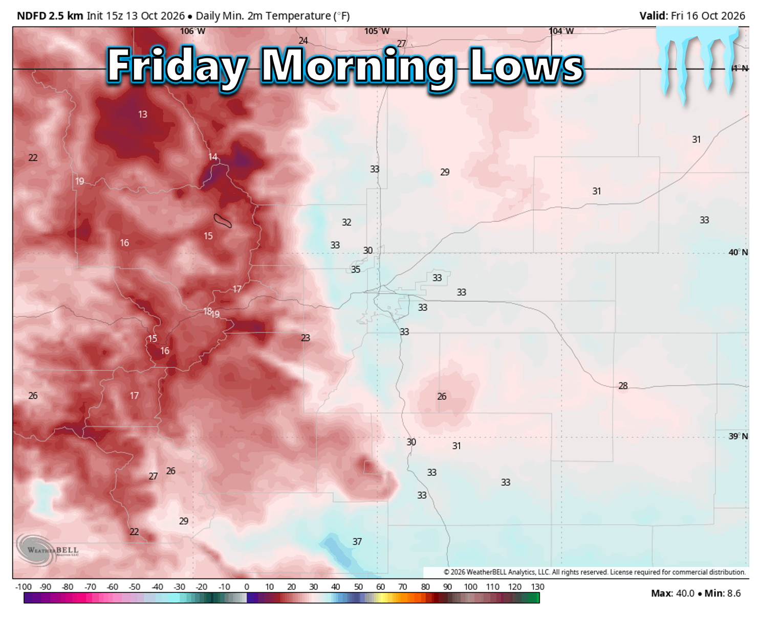
Finally, don’t overlook what happens after the storm moves out. A few lingering showers and clouds are possible Thursday morning, but skies should gradually clear by afternoon. While that will feel like a welcome change, it also sets the stage for something many Front Range gardeners and homeowners have been expecting: our first widespread frost, and possibly the season’s first light freeze, Thursday night.
Current forecasts bring temperatures across the lower elevations down into the upper 20s and lower 30s by Friday morning, which is cold enough to end the growing season for many sensitive plants. While we’re still about 72 hours away and temperatures could shift a few degrees warmer or colder, confidence is growing that freezing temperatures will become a concern. If you have outdoor plants, gardens, irrigation systems, or other cold-sensitive items, now is a good time to start thinking about preparations. Another chilly night is also possible Friday night before temperatures begin a more noticeable recovery over the weekend.
Storm Timeline
Tuesday Morning
- Low clouds, fog and patchy drizzle linger across the Front Range
- Mostly dry with cool temperatures
- Initial moisture and lift focused west of the Continental Divide
Tuesday Afternoon
- Clouds gradually break at times, though sunshine remains limited
- Highs in the upper 50s to mid-60s
- Isolated showers possible near the Foothills
Tuesday Evening Through Overnight
- Rain develops from west to east
- Showers become increasingly widespread
- A few embedded thunderstorms possible
- Moisture levels surge well above normal
Wednesday Morning
- Steady rain overspreads Boulder, Fort Collins and much of the Front Range
- Upslope flow strengthens
- Cool temperatures and gray skies dominate
Wednesday Afternoon And Evening
- Peak of the storm
- Persistent rain with periods of moderate intensity
- Heaviest rain focused across Boulder and Larimer Counties
- Snow levels continue lowering in the High Country
Wednesday Night Into Thursday Morning
- Rain gradually tapers from west to east
- Snow levels fall toward 7,000 feet
- Accumulating snow possible in higher Foothills communities
- Mountain snow continues before ending. Slick travel on Mountain passes.
Thursday
- Storm departs
- Improving conditions and decreasing precipitation
- Sunshine takes over later in the day
Thursday Night into Friday Morning
- Clear skies. Frost or a light freeze likely
Bottom Line
This is shaping up to be the Front Range’s most widespread and impactful precipitation event in many months. While not a perfect storm track, the combination of deep subtropical moisture, prolonged upslope flow and a slow-moving upper low should produce a beneficial soaking rain for much of north-central Colorado.
Boulder and Larimer Counties remain favored for rainfall totals approaching or exceeding one inch, while Denver and areas farther south should still receive meaningful precipitation, albeit with lower amounts and greater uncertainty. The Mountains will pick up their first significant snowfall of the season, with winter travel impacts likely at higher elevations. A couple nights of frost and/or light freezes will follow the storm, ending the growing season across the lower elevations.
Most importantly, this storm arrives at a critical time. Drought has been expanding across Colorado, fuels remain exceptionally dry for October and soil moisture deficits have continued to grow following an underwhelming monsoon season. One storm won’t erase over a year of moisture shortages, but it should provide the most meaningful drought relief many areas have seen since spring, while also offering us a reminder of what our weather should be like this time of year as we head into the cold season.
P.S. Don’t forget to enter your prediction for our 2026 First Snow Contest. It closes to entries on Friday October 16, 2026.
Spread the word, share our crazy Colorado weather:
Go Premium, get all the perks.
Daily Forecast Updates
Get our daily forecast discussion every morning delivered to your inbox.
All Our Model Data
Access to all our Colorado-centric high-resolution weather model graphics. Seriously — every one!
Ski & Hiking Forecasts
6-day forecasts for all the Colorado ski resorts, plus more than 120 hiking trails, including every 14er.
Smoke Forecasts
Wildfire smoke concentration predictions up to 84 hours into the future.
Exclusive Content
Weekend outlooks every Thursday, bonus storm updates, historical data and much more!
No Advertisements
Enjoy ad-free viewing on the entire site.











Leave a Reply
You must be logged in to post a comment.