


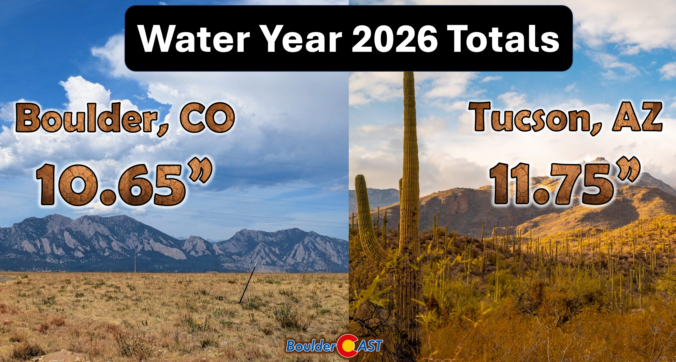
Boulder just endured its driest water year on record, closing out twelve months with only 10.65 inches of precipitation — barely half of normal and nearly at desert-level. From a failed snow season to record spring warmth and a monsoon that largely bypassed the city, every season conspired to keep Boulder locked in a warm‑and‑dry feedback loop. Reservoirs and upstream snow storage will cushion the blow for now, but the bigger question looms: what happens if we start stringing years like this together?
What You Need to Know
- Historically Dry — Boulder just recorded its all-time driest water year on record, nearly at desert-level and drier than locations in the actual desert (Tucson).
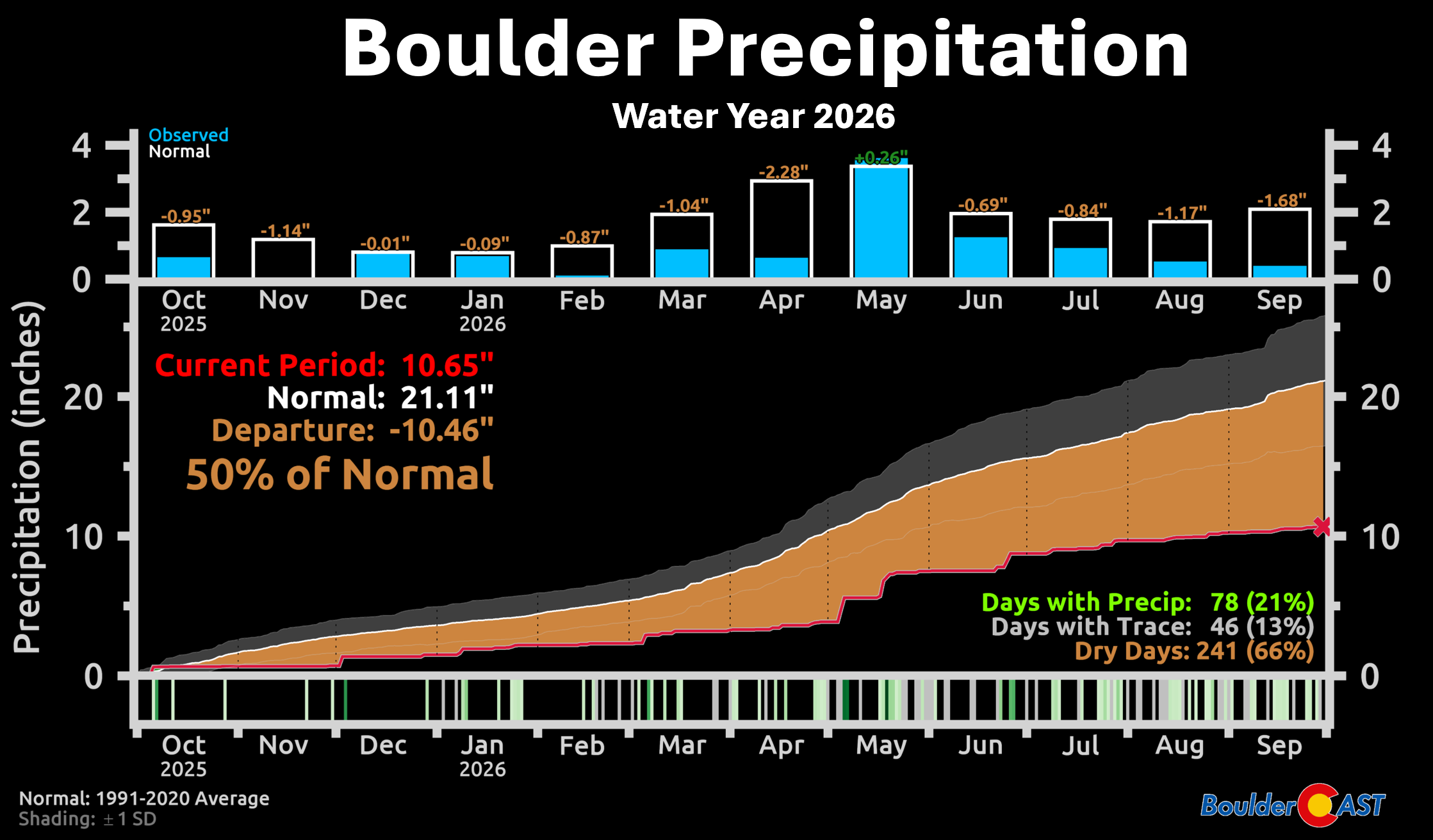
- Water Year Framework — October 1st to September 30th captures the full cool‑season cycle; Boulder logged deficits in 11 of 12 months, with May the lone exception.
- Failed Winter — The 2025–26 snow season collapsed, capped by a historic March heatwave that erased snowpack weeks to months early.
- Snow Drought — Boulder received just 41 inches of snow, the second‑lowest since 1950, with multiple winter storms falling entirely as rain.
- Monsoon Misses — Despite a late‑season surge fueled by El Niño and tropical cyclone activity, Boulder was largely bypassed by convective storms, leaving the city stuck in a warm/dry feedback loop.
- Record Warmth — Colorado experienced its warmest water year on record as well, compounding drought impacts through evaporation, soil drying, and accelerated snowmelt.
- Resilience but Risk — Reservoirs and upstream storage buffered supply this year, but consecutive hot, dry years like this would quickly erode that resilience.

Go Premium, get all the perks.
Daily Forecast Updates
Get our daily forecast discussion every morning delivered to your inbox.
All Our Model Data
Access to all our Colorado-centric high-resolution weather model graphics. Seriously — every one!
Ski & Hiking Forecasts
6-day forecasts for all the Colorado ski resorts, plus more than 120 hiking trails, including every 14er.
Smoke Forecasts
Wildfire smoke concentration predictions up to 84 hours into the future.
Exclusive Content
Weekend outlooks every Thursday, bonus storm updates, historical data and much more!
No Advertisements
Enjoy ad-free viewing on the entire site.
A Year Defined By Record Warmth, Record Dryness and a Complete Breakdown of the Seasonal Moisture Cycle
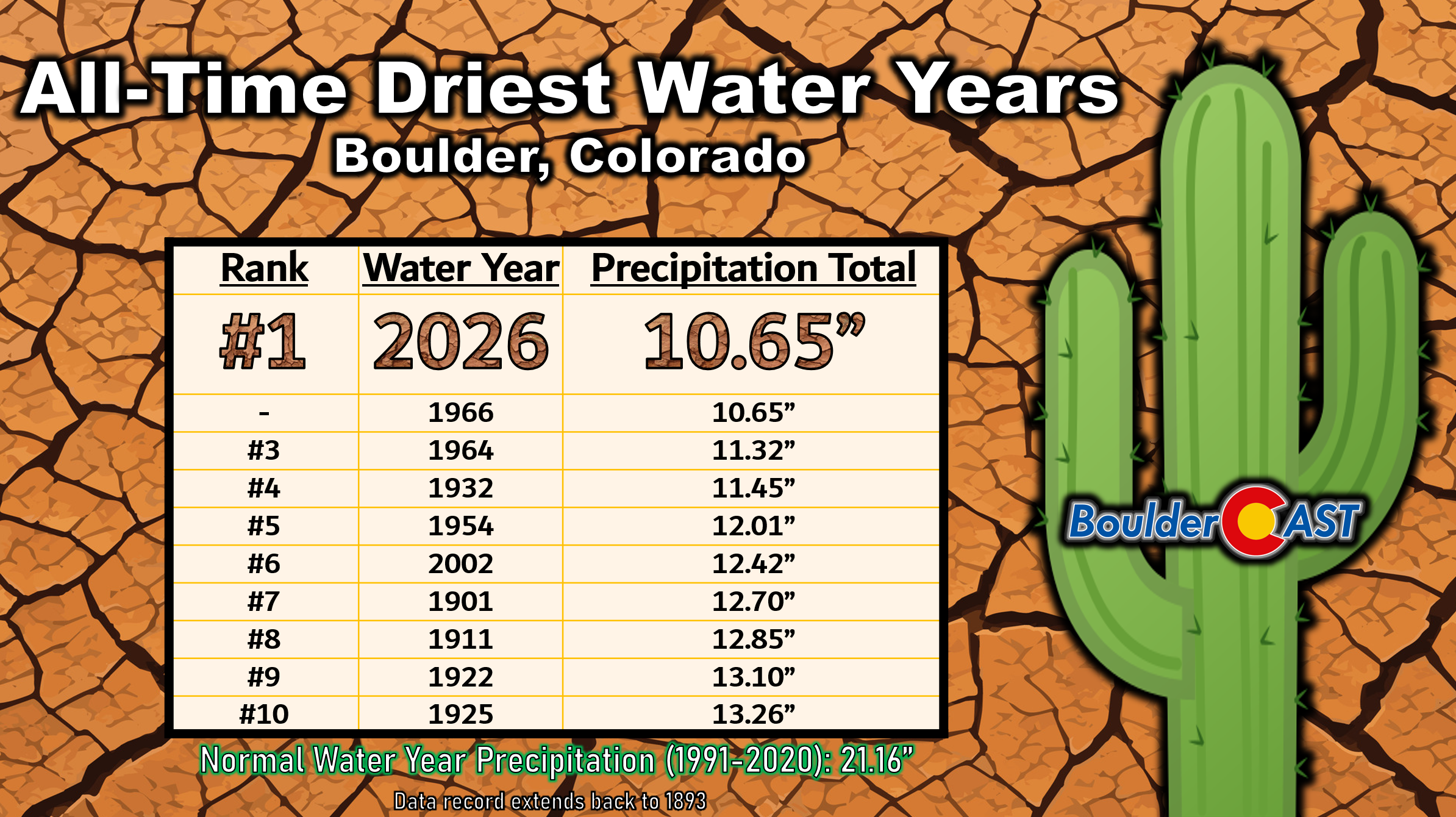
Boulder has officially tied its driest water year on record, closing out the October 2025 through September 2026 period with just 10.65 inches of precipitation — barely half of what we typically receive.
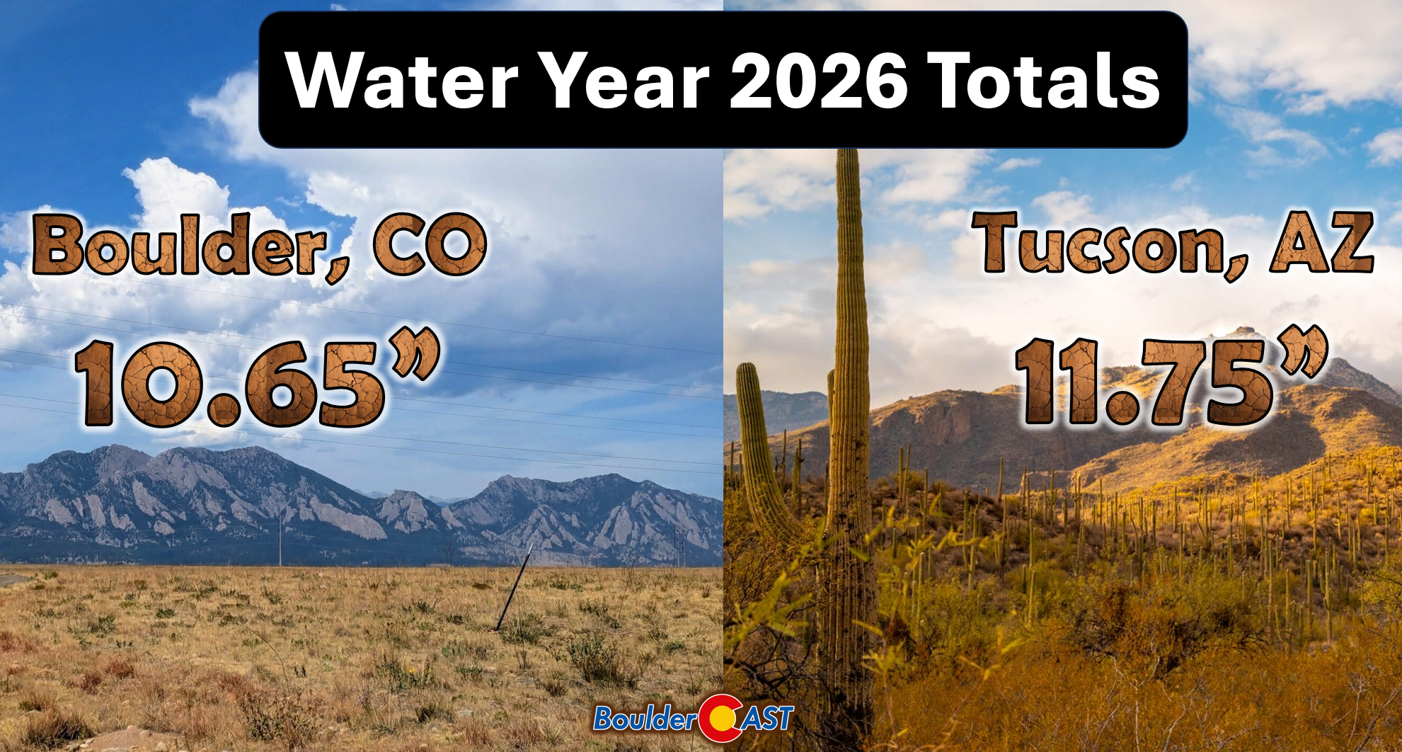
That number is remarkable on its own. For some perspective, climatologists generally classify places receiving less than about 10 inches of annual precipitation as desert climates. Boulder came remarkably close to that threshold this year — an almost absurd statistic for a city that normally picks up more than 20 inches of moisture annually.
Even Tucson, a city sitting squarely in Arizona’s Sonoran Desert, finished the water year wetter than Boulder thanks to a much more productive monsoon season across the Desert Southwest.
What Exactly Is a Water Year?
To appreciate just how extraordinary Boulder’s precipitation deficit was, it helps to step back and consider the framework of the water year. Unlike the calendar year, the water year runs from October 1 through September 30. That timing is deliberate: it captures the entire cool‑season accumulation cycle, including the snowpack that ultimately sustains rivers, reservoirs, and soils across the West.
Boulder’s water supply is heavily dependent on upstream terrain-basins and mountain storage rather than precipitation falling directly within city limits, but the water year remains a critical measure of how much moisture the local landscape actually received. And in 2025–26, the answer was not much.
Eleven of the twelve months finished below normal, with seven months delivering less than half of their typical precipitation. The only exception came in May, when a one‑two punch of strong upslope storms briefly broke the streak — one producing a damaging heavy snow event, the other a chilly, soaking rain.
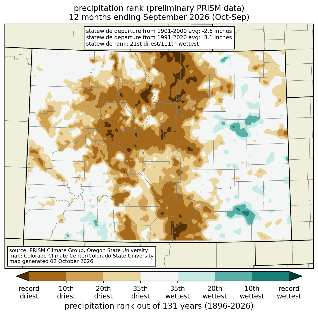
Much of the Front Range and Colorado mountains were exceptionally dry over the water year as well, with several areas — including Boulder as mentioned — recording their lowest precipitation totals on record for the full water year. Everywhere shaded in dark brown below can claim that prize.
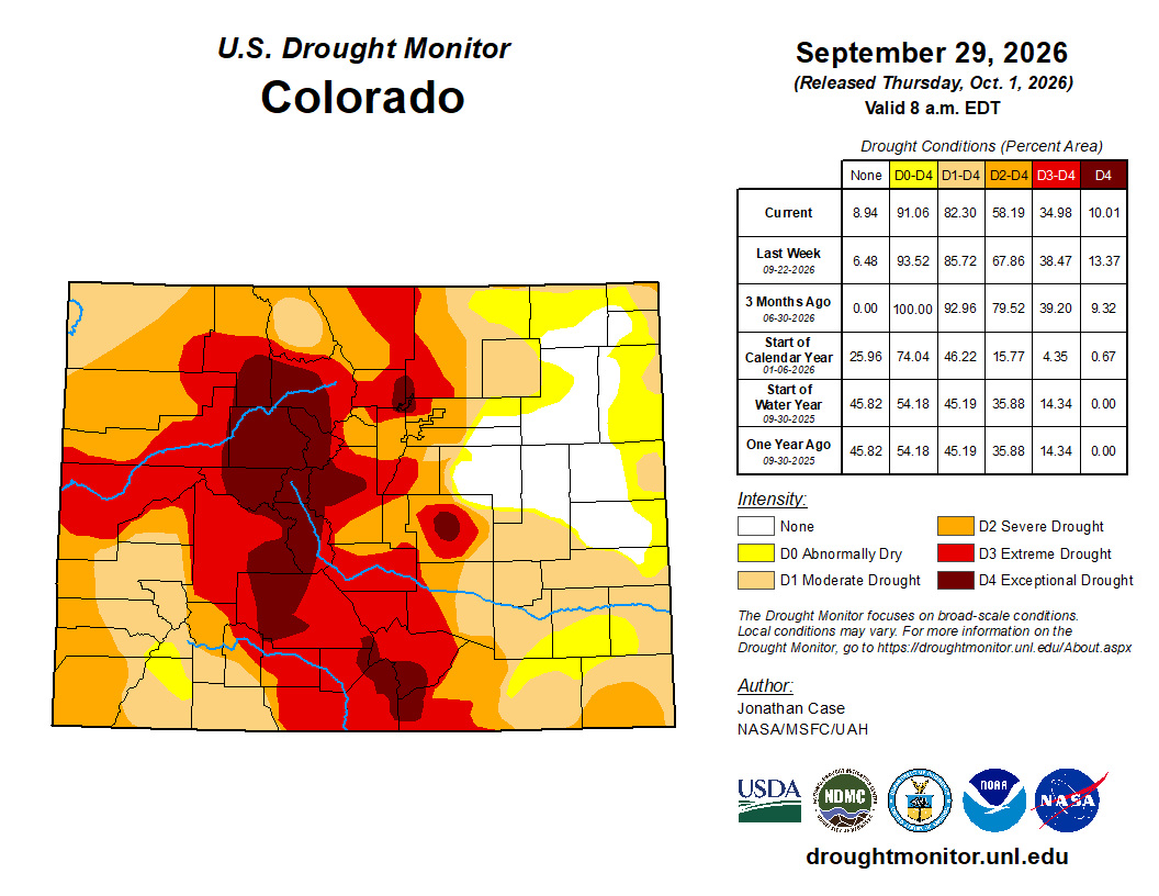
By the end of September 2026, 82% of Colorado was classified as being in drought, with 10% of the state in Exceptional Drought, the most severe category.
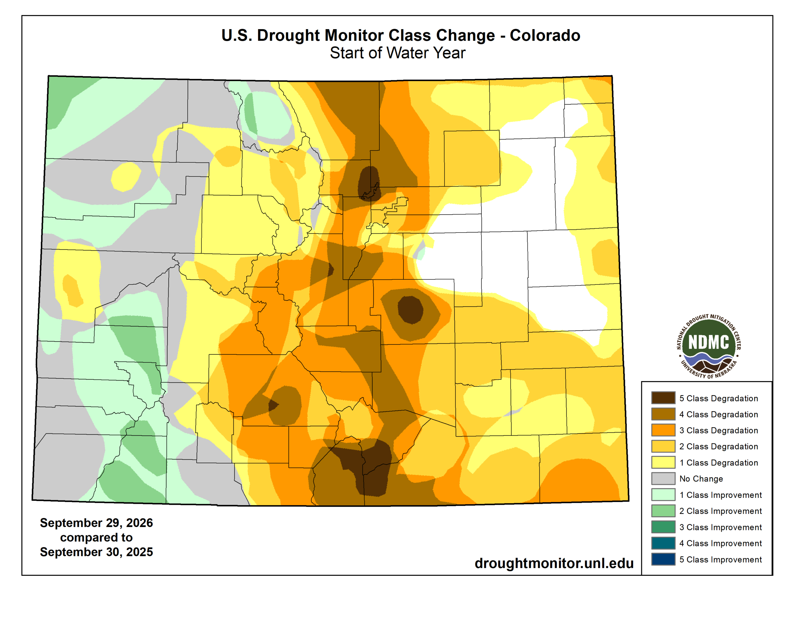
And this wasn’t a drought that appeared overnight. After 12 consecutive months of poor moisture, large portions of Colorado dropped three, four, and even five drought categories compared to a year earlier. Eastern Boulder County was unfortunately among the areas experiencing the full five-category deterioration.
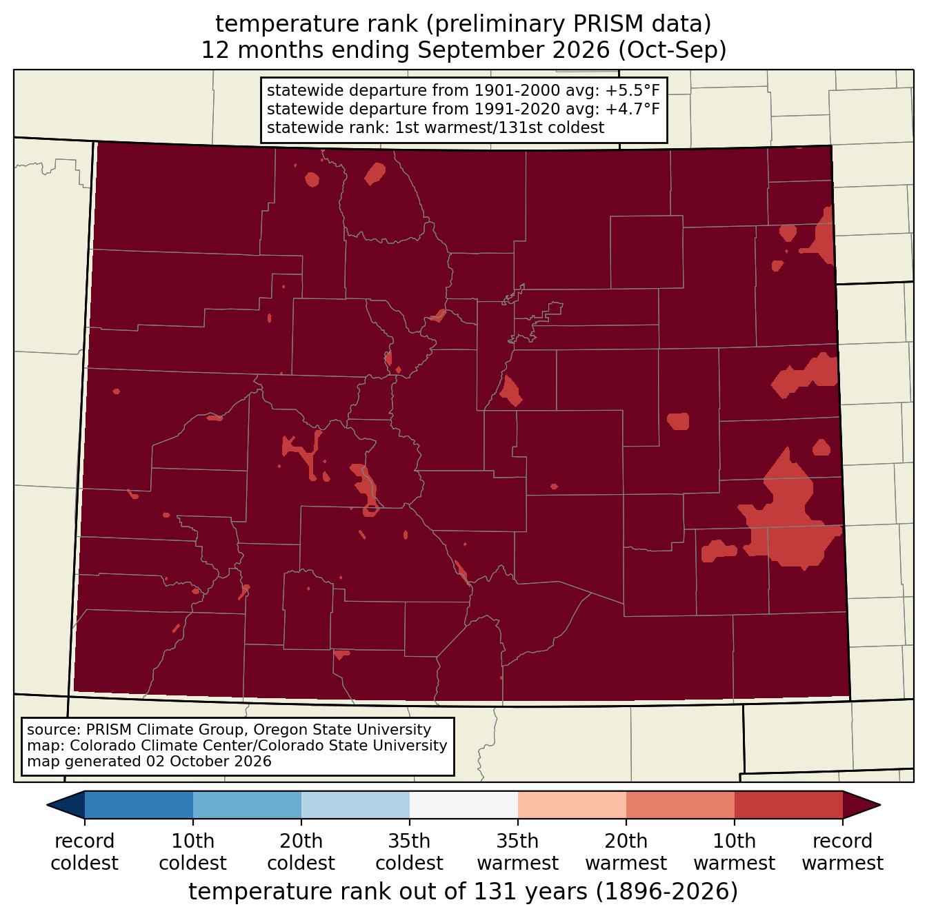
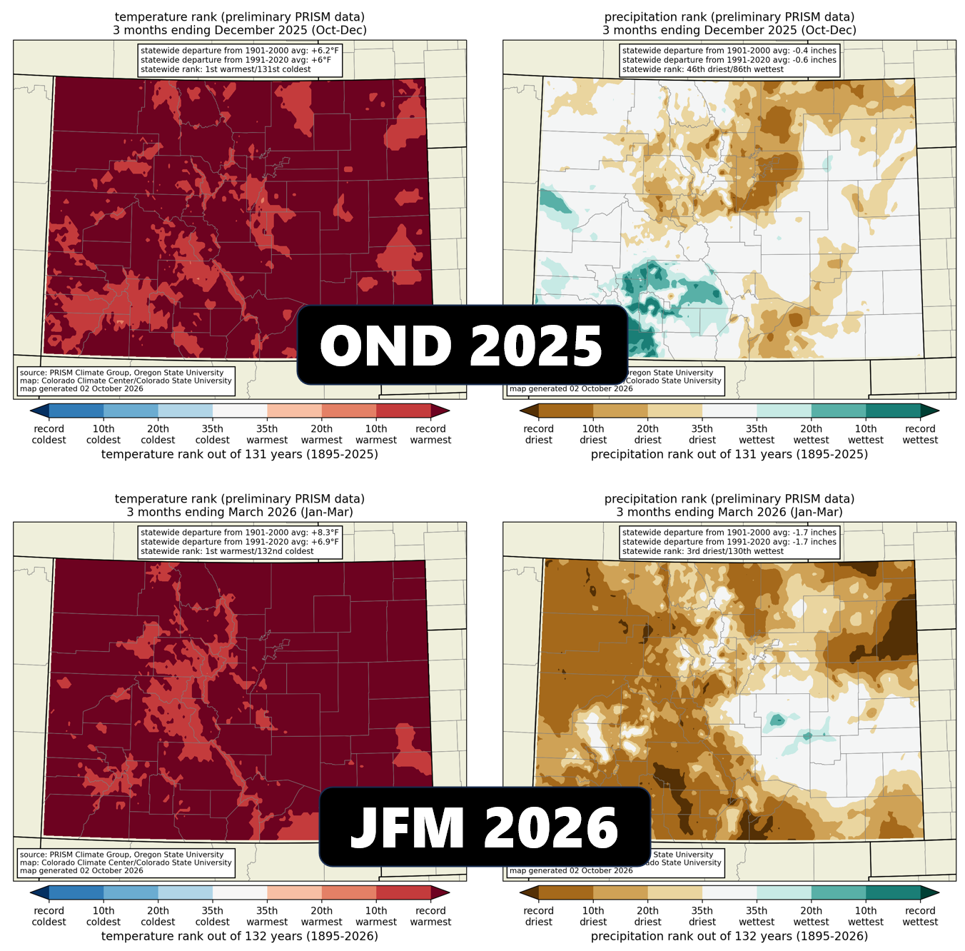
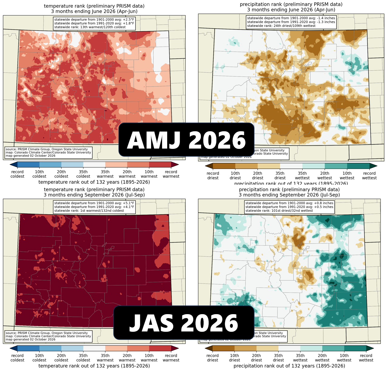
But the precipitation total only tells part of the story. The meteorological backdrop is arguably more important. Over the last 12 months, Colorado experienced its warmest water year on record as well.
This wasn’t a brief warm spell or a single season gone haywire. The warmth was persistent, widespread, and present in every season. And when temperatures stay this far above normal, the impacts compound: evaporation increases, soils dry out faster, atmospheric moisture is harder to retain near the surface, and snow melts earlier and more rapidly. In other words, the same amount of precipitation becomes less effective at alleviating drought.
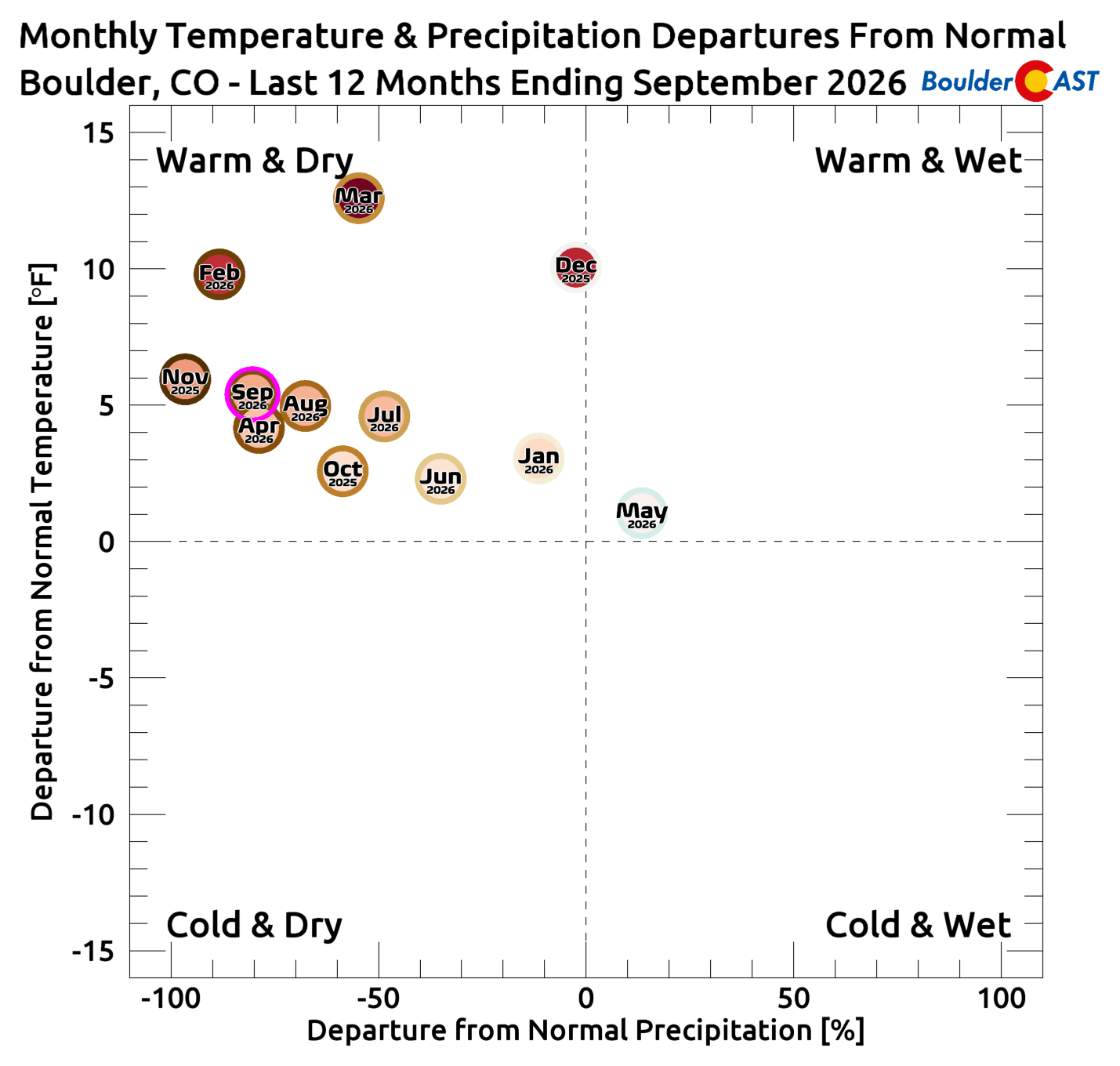
Eleven of the last twelve months in Boulder landed squarely in the warm-and-dry quadrant on our temperature-versus-precipitation anomaly chart. It’s hard to find a better illustration of just how persistent the pattern was. If you find one, let us know in the comments.
The Snow Drought Made Everything Worse
The water year’s snowfall told essentially the same bleak story.
Boulder ended the 2025–26 snow season with just 41 inches, the 4th lowest seasonal snowfall total since 1950. Denver fared even worse.
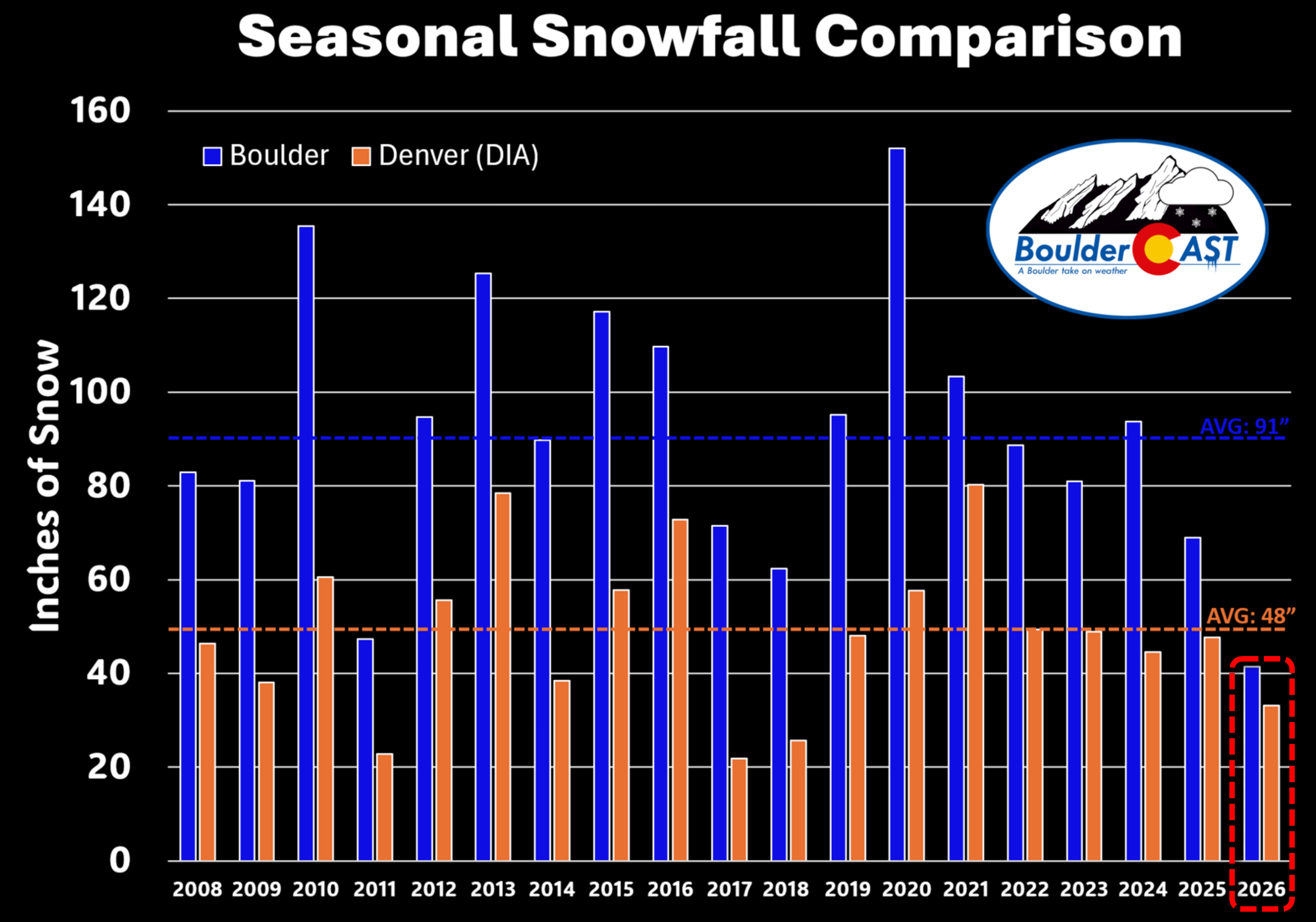
This wasn’t simply a case of a few storms missing Boulder. The entire cold season was structurally unfavorable.
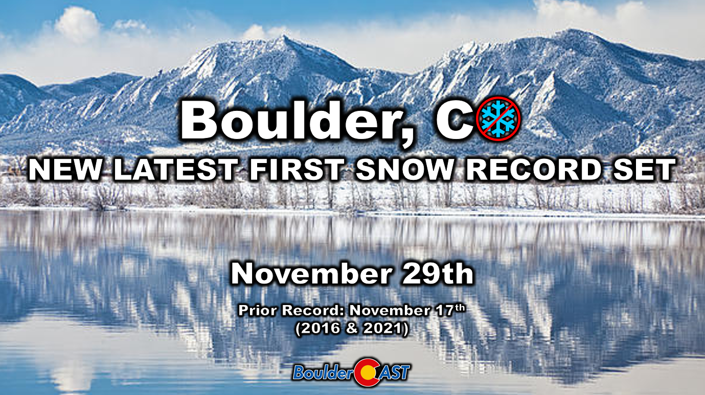
It started in autumn, which was almost completely snow-free. Boulder recorded its latest first snowfall on record, by nearly two weeks.
Ultimately, winter never found its footing here. Storms were weaker, less frequent, and repeatedly derailed by stubborn blocking ridges that kept the jet stream fractured. Even during the short stretches when the pattern briefly improved, storm tracks consistently missed the Front Range. And when precipitation did reach Boulder, temperatures were often too warm to support snow. Several systems in February, March, and April delivered nothing but rain — right in the heart of what is normally Boulder’s prime snow season.
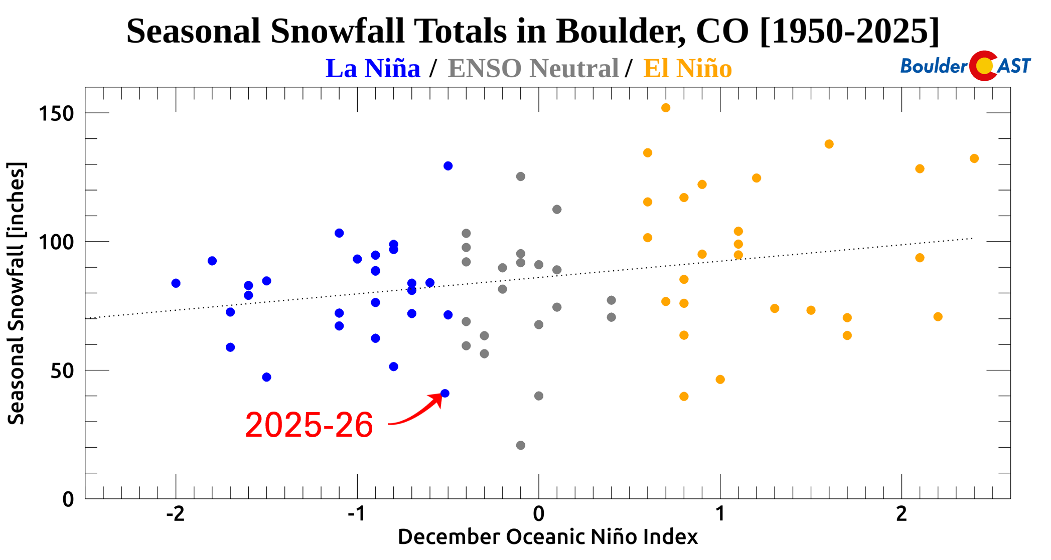
Many like to chalk this up to the weak La Niña, but the data tell a different story: last winter gave Boulder less snow than any previous La Niña, strong or weak.
The Mountains didn’t fare any better last winter. The 2025–26 snow season never really got off the ground across the West, something we documented here back in February when we called the ongoing winter a “complete failure across the West”.
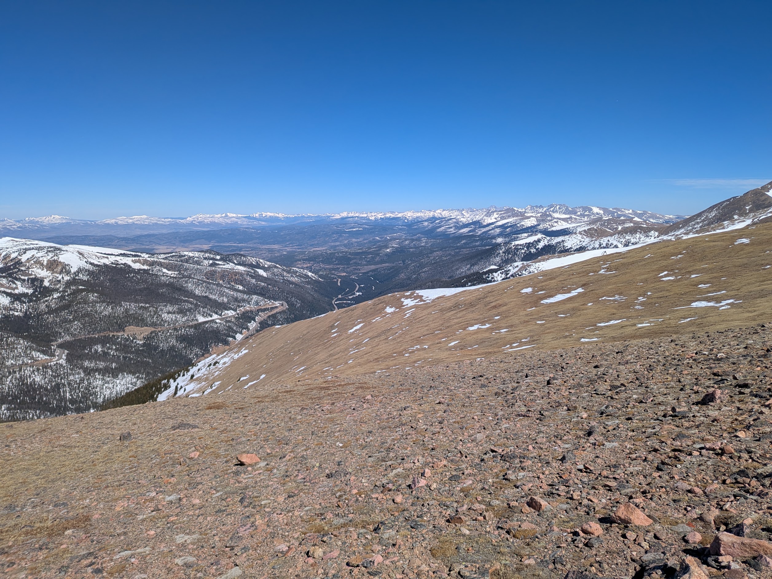
Upper Colorado Basin lacking snow, March 21 2026
Mountain snowpack was already running well below normal heading into early spring, but the historic March 2026 Western heatwave delivered the knockout blow.
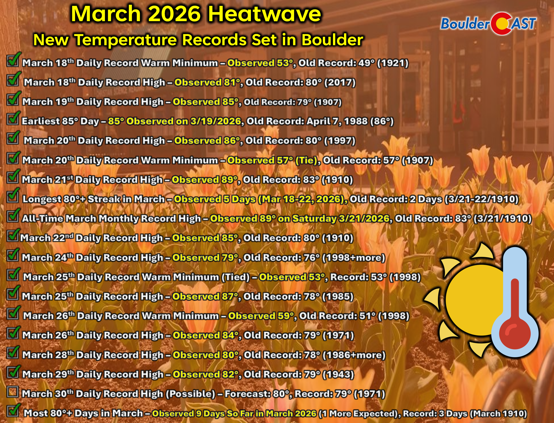
Temperatures soared to record levels for almost two weeks straight, even at very high elevations, rapidly erasing much of the remaining dismal snowpack. Numerous basins across the West melted out weeks or even months earlier than normal, effectively losing their seasonal water storage before spring had even begun.
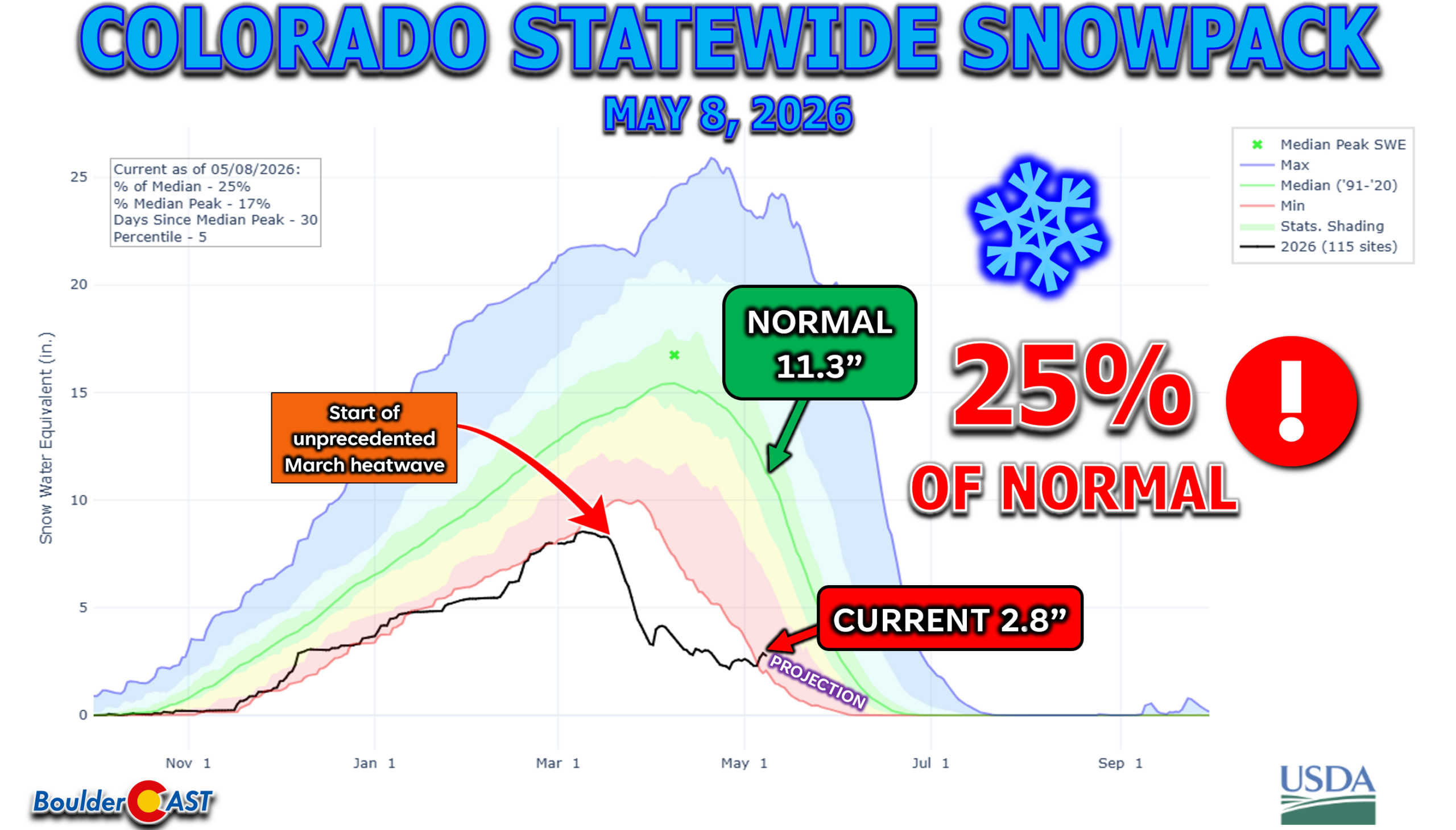
That timing matters. Mountain snowpack acts as a natural reservoir, slowly releasing water into streams and soils throughout spring and early summer. Without that cold-season foundation, soils entered spring dry, reservoirs had to lean more heavily on existing storage, and the region lost the gradual moisture release that normally helps buffer the transition into the warm season. This is about the time that many cities across the Denver Metro area started enacting drought-related water restrictions.
Even the Monsoon Couldn’t Save Us
By the time summer arrived, the North American monsoon seemed poised to offer Boulder a reprieve from the relentless dryness. In much of Colorado, that promise was realized. The 2026 monsoon began sluggishly but eventually surged in August and September, energized by a strengthening El Niño and an unusually active eastern Pacific tropical cyclone season that funneled deep subtropical moisture into the Southwest. Across large portions of the state, this late‑season revival brought meaningful rainfall, cooler afternoons, and a slight easing of drought conditions.
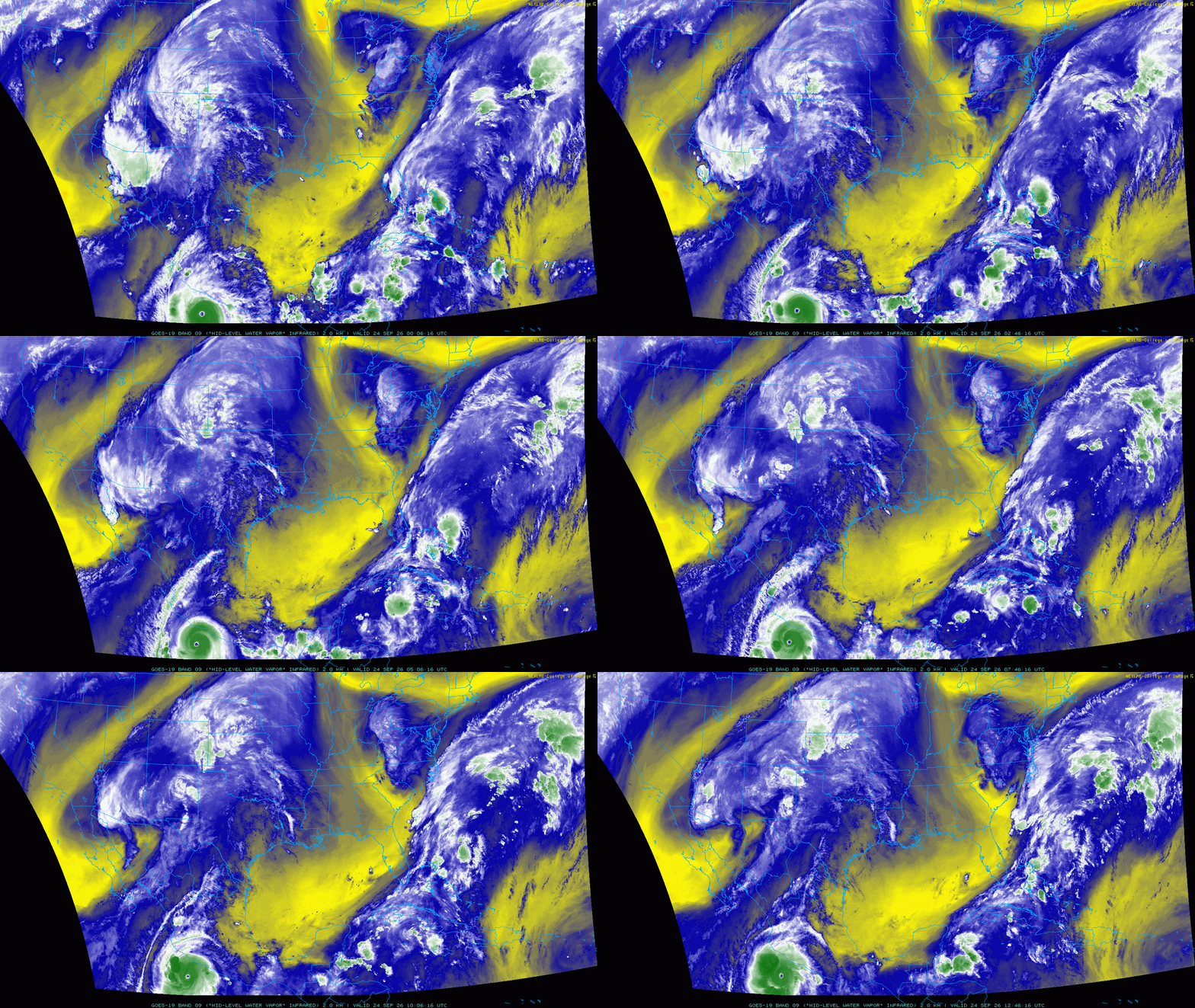
Hurricane Polo spins off the Mexican coast in late September. About six days later it would become a major player in southern Colorado’s weather.
But Boulder was left behind. Eastern Boulder County remained largely untouched by the monsoon’s best surges. The Foothills did see more frequent storms, some of which sparked small lightning‑caused wildfires, yet many of those cells weakened before descending into the city. Others tracked just north or south, leaving Boulder proper dry once again. More than 5 inches of monsoon rains fell just 10 miles west of Boulder in the Foothills, but at the official climate station, just 1.89″ of rain accumulated through monsoon season.
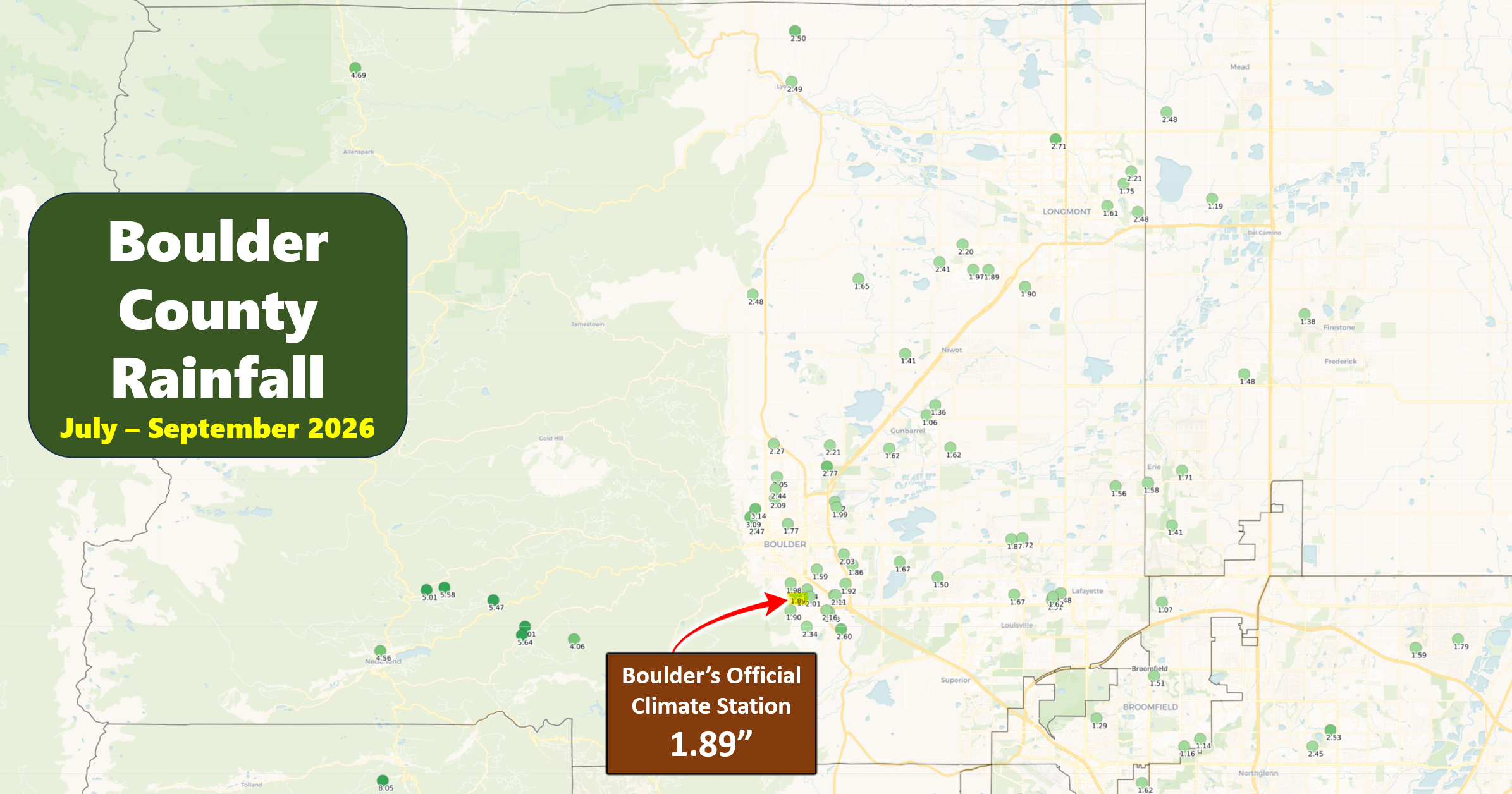
Even as the broader region benefited from increased moisture, Boulder remained locked in the same warm‑and‑dry feedback loop that had dominated the previous ten months. The monsoon’s revival was real, but for Boulder it was more a story of missed opportunities than meaningful relief.
Bottom Line
The ingredients for Boulder’s driest water year aligned with remarkable precision in 2026, producing a hydrologic nightmare that spanned every season of the year. A snow‑starved autumn and winter provided little moisture to begin with, leaving the landscape vulnerable heading into spring which featured persistent blocking ridges that suppressed mid‑latitude storm systems, diverted the jet stream, and repeatedly steered moisture away from the Front Range. When the summer monsoon finally became more active, its most productive surges favored the Mountains and other parts of Colorado, while Boulder itself was largely bypassed by convective storm tracks and unlucky storm weakening. Record warmth throughout the water year amplified evaporation rates, dried soils, and accelerated snowmelt across the region, making even the precipitation we did receive less impactful.
The result was not simply a dry year. It was a multi‑season hydrologic failure, a breakdown of the our normal moisture cycle from start to finish. Boulder never managed to establish a meaningful surplus of precipitation at any point in the water year. After twelve consecutive months of warmth and remarkably little precipitation, Boulder closed the water year with 10.65 inches of moisture — tying the driest water year ever recorded here. For a city that normally receives more than 20 inches annually, this marks an extraordinary and sobering milestone, underscoring how vulnerable the Front Range is when multiple climate drivers converge to suppress precipitation across every season.

Click to enlarge table
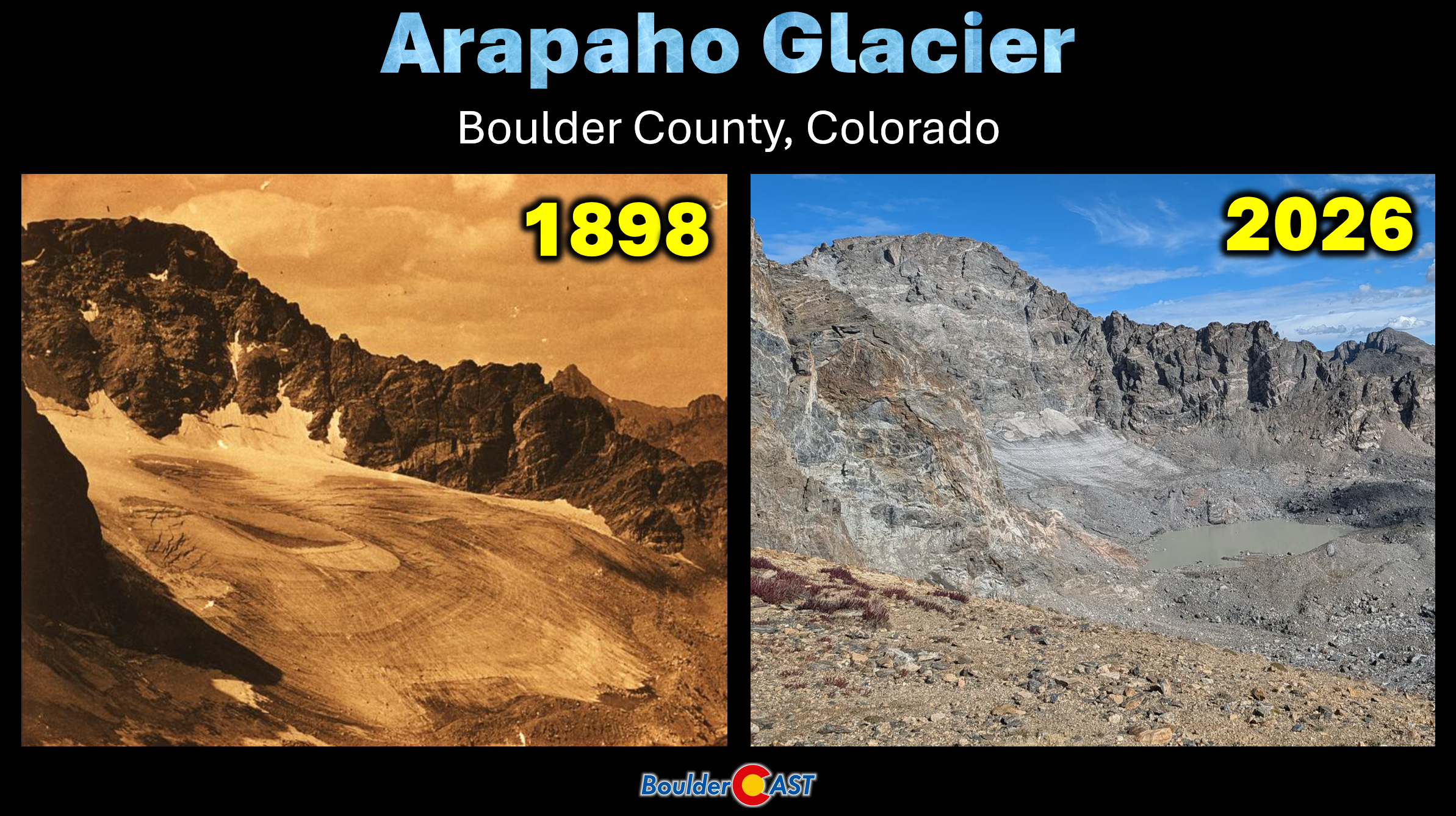
And yet, despite the severity of this single year, Boulder’s water system is resilient enough to absorb the blow for now. Reservoirs remain adequately stocked, dwindling upstream snowpack and glacial reserves continue to buffer the supply, and the infrastructure built to withstand precipitation variability is still functioning as intended. That reality should temper community panic, but it also underscores the stakes at hand: one exceptionally dry water year, like this one, can be managed, but a string of them would quickly erode our reserves. The hope now is that this record‑setting water year stands alone, rather than marking the beginning of a troubling new sequence.
Spread the word, share our crazy Colorado weather:
Go Premium, get all the perks.
Daily Forecast Updates
Get our daily forecast discussion every morning delivered to your inbox.
All Our Model Data
Access to all our Colorado-centric high-resolution weather model graphics. Seriously — every one!
Ski & Hiking Forecasts
6-day forecasts for all the Colorado ski resorts, plus more than 120 hiking trails, including every 14er.
Smoke Forecasts
Wildfire smoke concentration predictions up to 84 hours into the future.
Exclusive Content
Weekend outlooks every Thursday, bonus storm updates, historical data and much more!
No Advertisements
Enjoy ad-free viewing on the entire site.











Leave a Reply
You must be logged in to post a comment.