The spring storm rolling across the Front Range has already pulled off quite a transformation, shifting from rumbles of thunder to flakes of heavy, wet snow in just 12 hours. What comes next is shaping up to be even more impressive. Two separate storm systems are preparing to merge over Colorado and the result will be a long stretch of heavy wet snowfall that will have significant impacts for our fully leafed-out trees and power lines. We break down why snowfall amounts have ticked up a tad since yesterday, when and where power outages are most likely to occur, and the broader impacts this wet storm will have across Boulder, Denver and the Front Range.
What You Need to Know
🌩️ Thunderstorms Monday transitioned to some wet snowflakes overnight as colder air pushed into the Front Range
❄️ Two storm systems are still on-track to phase over Colorado, creating a long 24+ hour window for steady, heavy wet snow
🧊 Cold air deepens Tuesday night with 700 mb temps dropping below –10°C and near‑perfect ENE upslope into the Front Range. This is when the craziest snow will occur.
🌧️ Moisture bullseye remains locked over Boulder and Larimer Counties where 1–2.5″ of liquid is favored with some boom potential. Still impressive ~1″ liquid totals favored in Denver.
🌨️ Heaviest snow accumulation expected Tuesday evening through Wednesday morning with snowfall rates over 1.5″/hr at times.
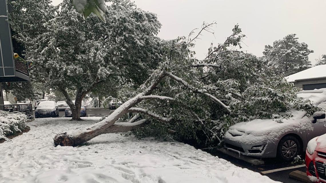
🌳 Widespread tree damage and power outages are likely as wet snow loads onto fully leafed vegetation and power lines. Shake off your trees during the storm and park cars well clear of any trees.
🚗 Travel impacts peak late Tuesday evening into Wednesday morning with slushy roads despite warm pavement temps.
🥶 Sub-freezing temperatures will occur Tuesday night and Wednesday night, so plan accordingly by protecting sensitive plants and draining above ground pipes.
💧 Despite the disruption, the storm could be big enough to bring meaningful drought improvement and prop up the fading snowpack in the South Platte Basin

Go Premium, get all the perks.
Daily Forecast Updates
Get our daily forecast discussion every morning delivered to your inbox.
All Our Model Data
Access to all our Colorado-centric high-resolution weather model graphics. Seriously — every one!
Ski & Hiking Forecasts
6-day forecasts for all the Colorado ski resorts, plus more than 120 hiking trails, including every 14er.
Smoke Forecasts
Wildfire smoke concentration predictions up to 72 hours into the future.
Exclusive Content
Weekend outlooks every Thursday, bonus storm updates, historical data and much more!
No Advertisements
Enjoy ad-free viewing on the entire site.
What Happened Already: Thunderstorms to snow
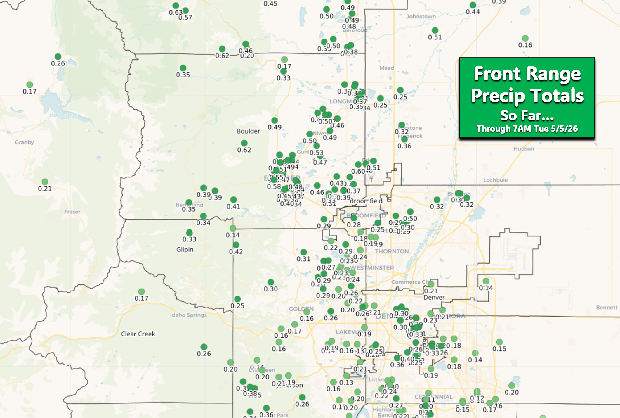
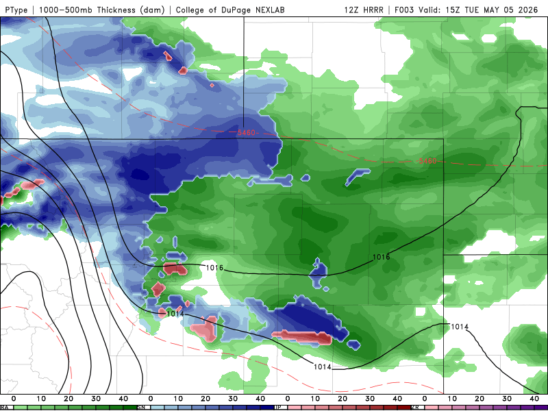
Around of scattered showers and thunderstorms fired Monday afternoon and evening right on schedule as the Front Range remained firmly in the warm sector ahead of the initial cold front. Intermittent rain showers persisted through the night, with snow quickly overtaking the higher terrain and now beginning to mix in across the lower elevations as colder air filters in. We’ve seen a mix of rain, graupel and wet snowflakes here in Boulder so far Tuesday morning, with now more of a drizzle occurring.
Healthy moisture totals have already dumped, with one quarter to one half inch having fallen over much of the Metro area and higher terrain. That was just the start of things to come — the meat and potatoes of the main storm are still moving in!
Broader Storm Evolution Now Favors a Longer Duration of Snow
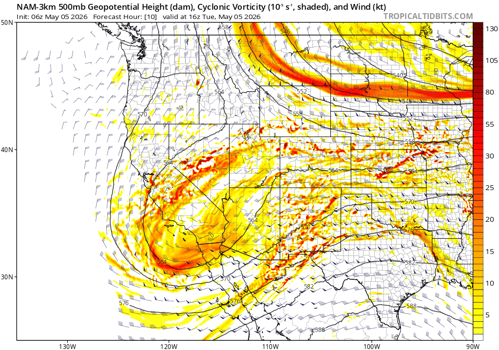
Not much has changed in the large‑scale setup compared to our discussion 24 hours ago, so we’ll keep the focus on what matters most: the phasing of two distinct upper‑level disturbances directly over Colorado during the next 36 hours. This pairing is what will drive a prolonged period of heavy, wet snow across the entire region — a setup that genuinely resembles the meteorological plotline of The Perfect Storm.
Here’s the breakdown:
- A closed low over California is drifting eastward, dragging a deep plume of Pacific moisture along the subtropical jet.
- A cold northern‑stream trough is diving straight into Colorado from western Canada, delivering the cold air needed to flip rain to snow even at the lowest elevations.
Both of these features can be seen coming together in the forecast animation below:
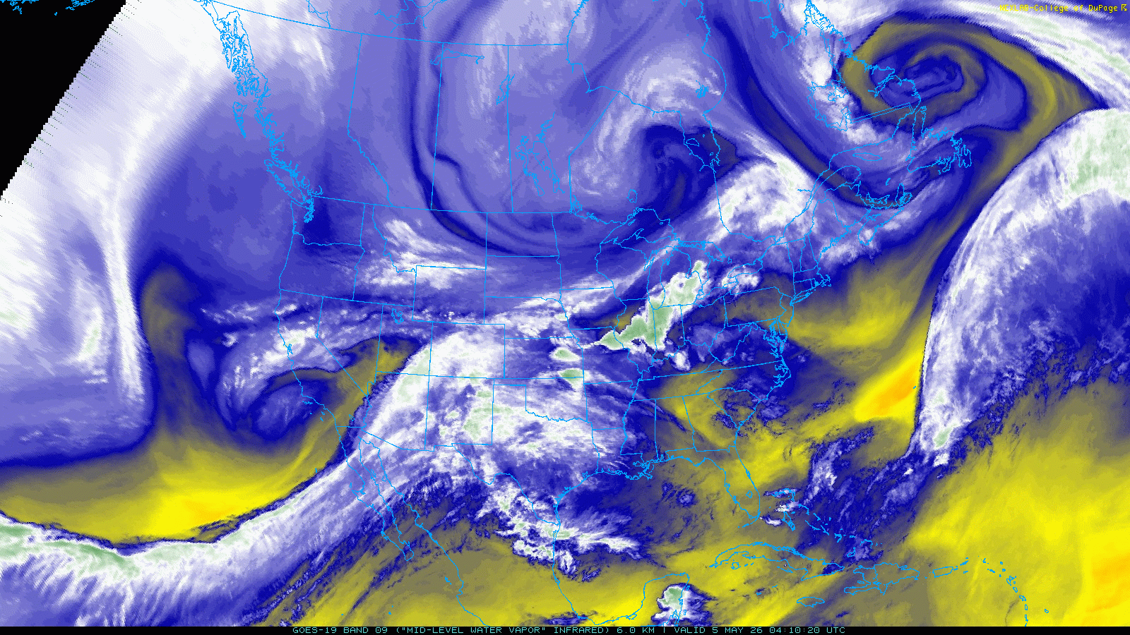
And water vapor imagery from Tuesday morning shows them plainly: one to our north, one to our southwest, both on a collision course for Colorado!
If anything has changed, it’s that the northern wave is arriving slightly slower. Counterintuitively, this does not seem to disrupt the phasing. There is abundant cold air ahead of the trough and ample moisture streaming in already. Instead, the slower timing simply will extend the duration of winter weather well into Wednesday, with snow unlikely to taper until late Wednesday afternoon or evening. That leaves roughly 36 hours of steady precipitation potential for the entire Front Range corridor.
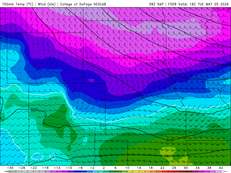
The most efficient upslope and coldest air will arrive late Tuesday evening as the northern wave digs in and a mid‑level low forms and sinks southward across western Colorado. This evolution draws in impressively cold air for May, with 700 mb temperatures plunging below –10°C after midnight Tuesday night into Wednesday morning. As the low deepens to our west, wind fields across the Front Range turn sharply ENE and strengthen to around 20 MPH at 700 mb — a near‑perfect upslope orientation for Boulder and Larimer Counties. This strong, sustained upslope is projected to persist through at least midday Wednesday, if not a bit longer.
The timing of the best upslope and cold air will also conveniently overlap with strong frontal forcing (i.e. convergence) and jet forcing, with a plethora of heavy snow bands expected through the night. It’s unclear where exactly these bands may setup hardest, but it’s likely to be somewhere north of Interstate 70 and south of Loveland. Where these heavy bands linger longest will have the higher-end totals.
Moisture Forecast Unchanged: Boulder and Larimer Still Favored
Model guidance remains consistent regarding both the placement and magnitude of the precipitation bullseye. The highest likelihood for 1.0–2.5 inches of liquid remains centered on Boulder and Larimer Counties, with the axis of heaviest precipitation extending eastward toward Kansas.
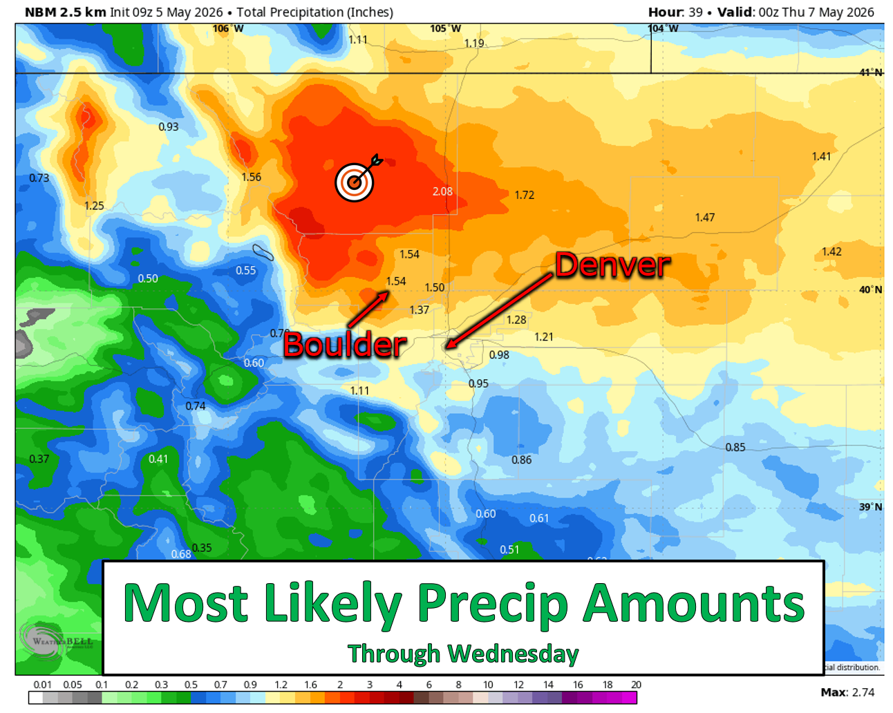
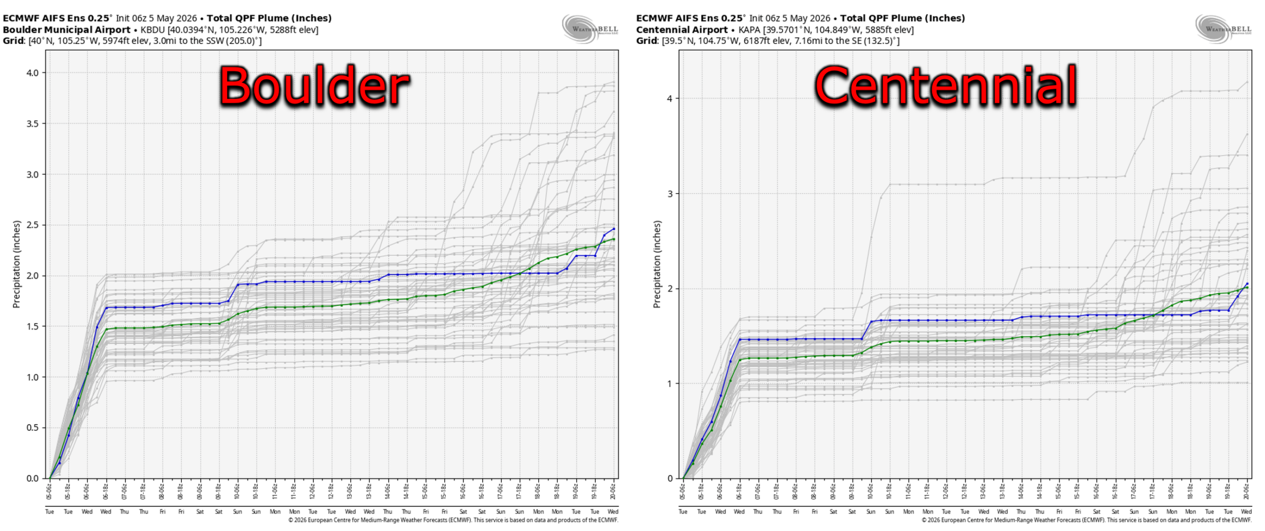
A northward bias continues to show up in the data, meaning the southern Denver Metro will likely come in lower than the northern tier — but not by much. Depending on the model, the southern suburbs still appear on track for 0.8–1.5 inches of liquid. For example, the Euro AI ensemble comparison between Boulder and Centennial highlights this gradient well.
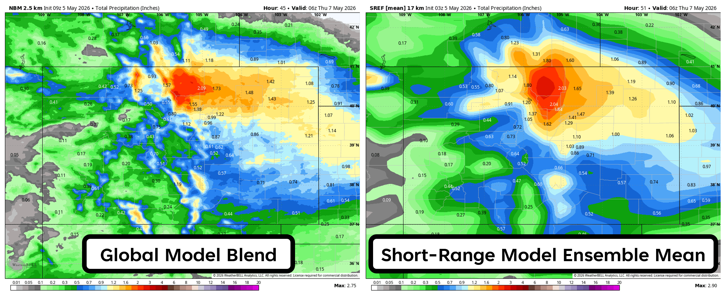
Short‑range models continue to run hotter than the globals, broadly hammering the entire Denver Metro and coming in roughly 25% wetter overall. This discrepancy leans the event toward boom potential (higher totals than forecast) rather than bust potential. Regardless, this is a widespread, soaking precipitation event that will benefit vegetation, wildlife, reservoirs, and the South Platte Basin snowpack. Unlike last week’s underperforming system, everything remains aligned for a legitimate late‑season blast of wet snow across the region — for better or worse.
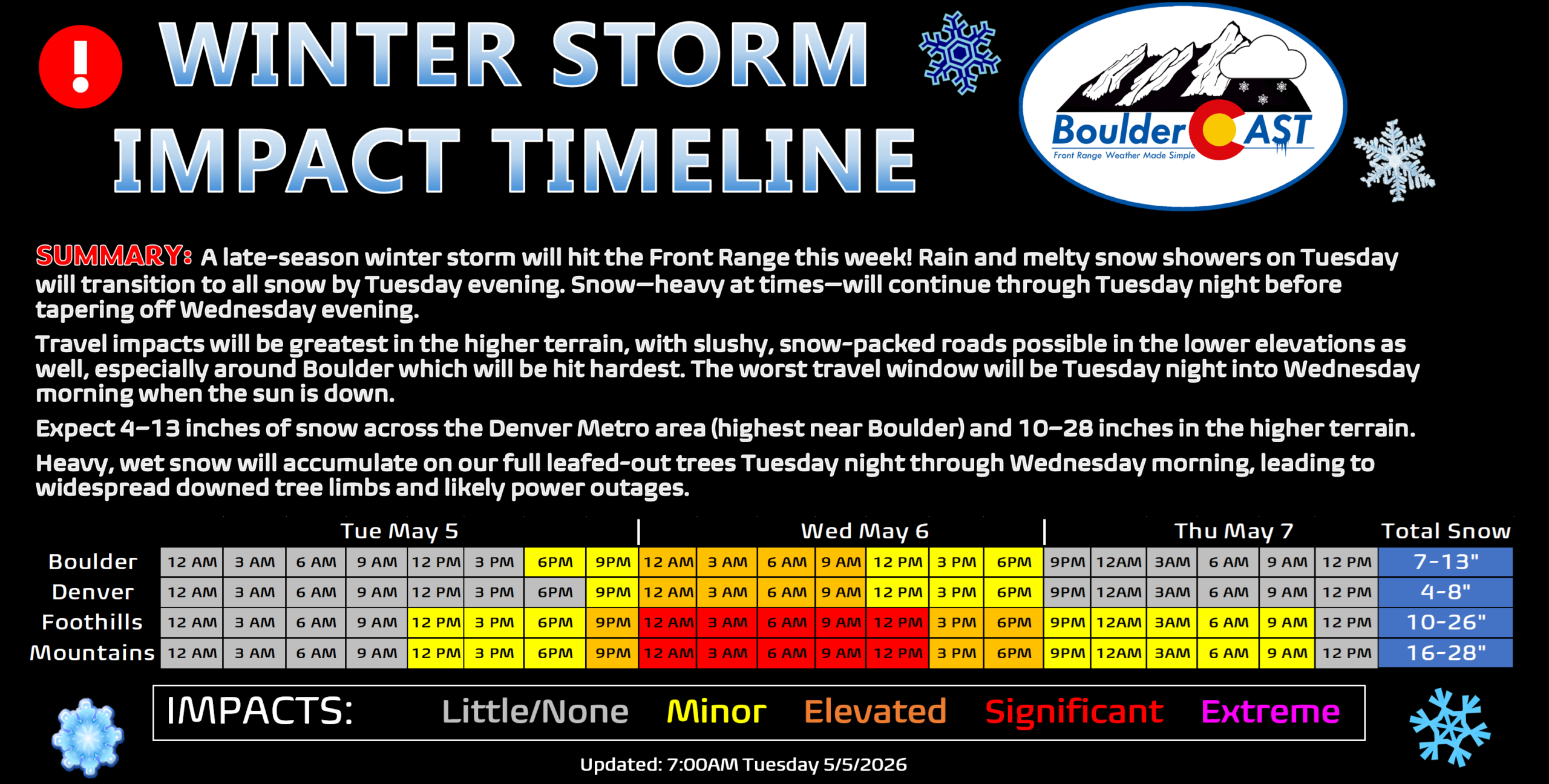
Timeline of Events
Here’s how we expect the storm to unfold as we move through this soggy, wintry stretch:
- Tuesday: Rain transitions to wet snow across the lower elevations, with all snow in the Foothills. Some areas may hold a rain/snow mix much of the day due to limited cold air advection until later. Minor grassy accumulations (dusting to 2″) possible by sunset. Roads remain wet.
- Tuesday night: Snow continues everywhere, heavy at times, with embedded bursts exceeding 1.5″/hour rates. Snow begins sticking regionwide. The bulk of accumulation occurs from 6 PM Tuesday through late Wednesday morning, when the May sun is down or low on the horizon. Lows fall to 27–31°F. Tree damage and power outages begin after midnight. Roads become treacherous in the Foothills/Mountains and slushy to sludge‑packed across the lower elevations.
- Wednesday: Snow continues through the morning, heavy at times, tapering during the afternoon or evening. Tree damage and outages continue as wet snow accumulates on fully leafed vegetation. Despite ongoing snowfall, road conditions improve during the day as the May sun works through cloud cover.
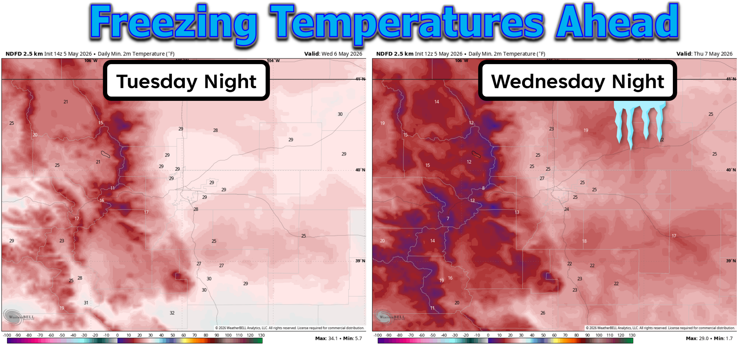
- Wednesday night: Skies partially clear and temperatures drop below freezing again, likely 23–28°F, with teens in the Foothills.
- Rest of week: A rapid warmup follows. Highs rebound into the 70s by Friday. Thursday’s temperatures will depend heavily on how much snow remains to melt, ranging from the lower 50s to mid‑60s.
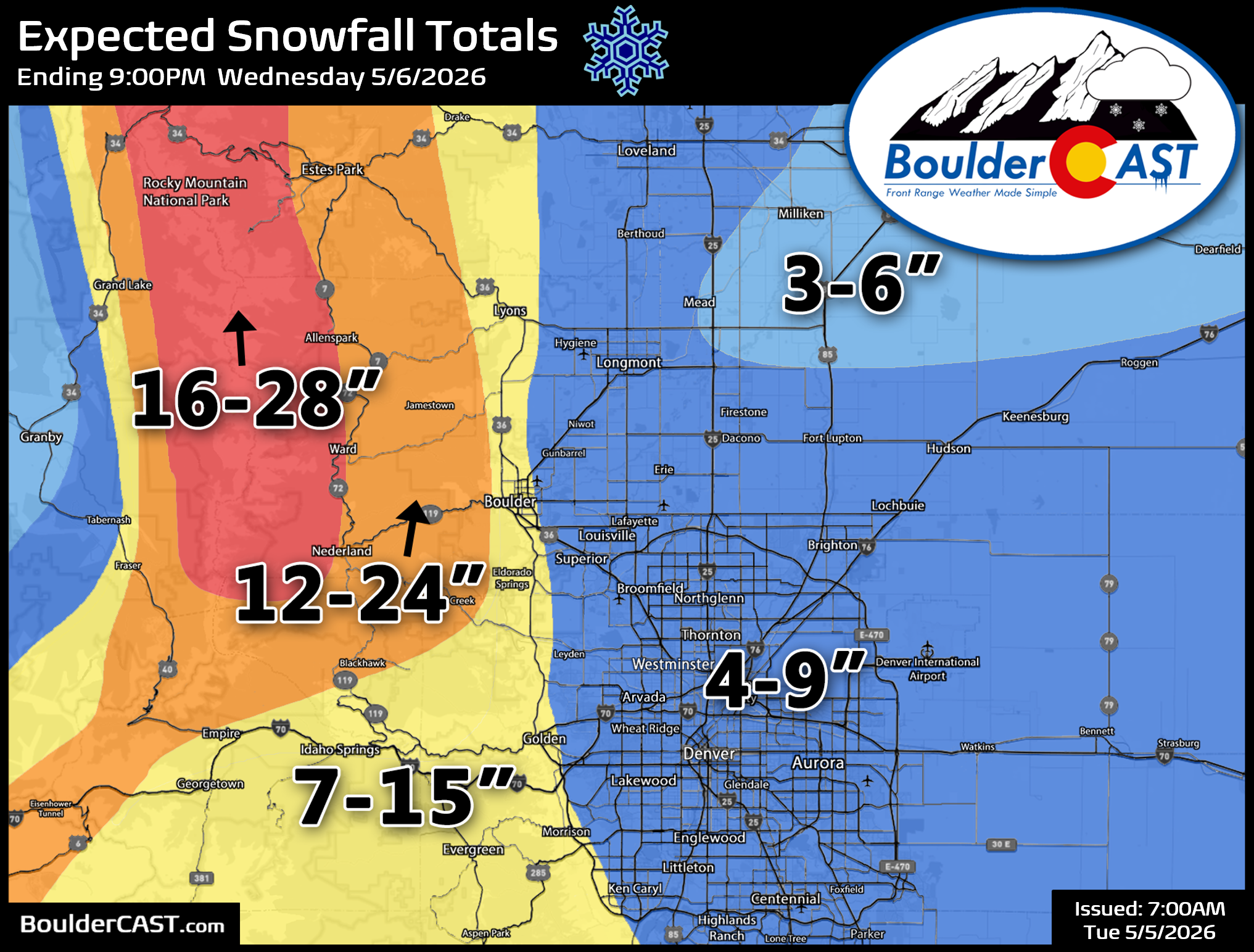
Snowfall Forecast Amounts
Based on the latest model trends and current observations, we’re nudging totals upward slightly. The slower northern wave extends the window for moderate to heavy snowfall through Wednesday morning. Our final snowfall forecast map is below. We’re generally expecting 4 to 9 inches throughout the heart of Denver, closer to 7 to 12 inches in Boulder, and much higher totals in the Foothills generally from 1 to 2 feet (with locally up to 3 feet in the luckiest spots).
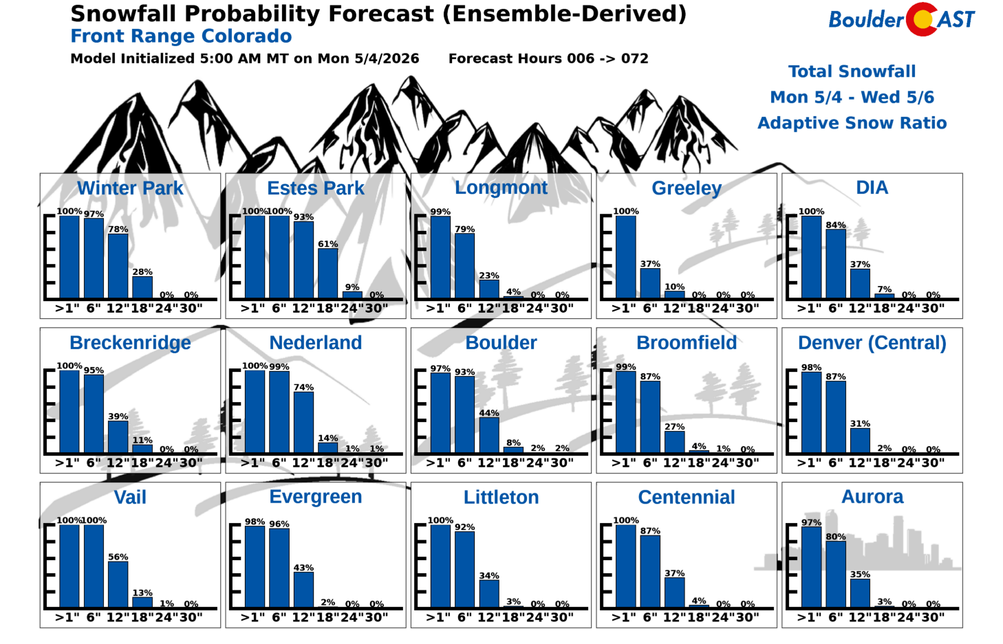
Our latest Snowfall Probabilities give an idea of the spread in potential snowfall amounts at various locations across the Front Range. These may be running a tad high due to models underestimating how much melting there will be, but these should be close. These odds also show the potential for booming totals that could land higher than the most likely forecast amounts.
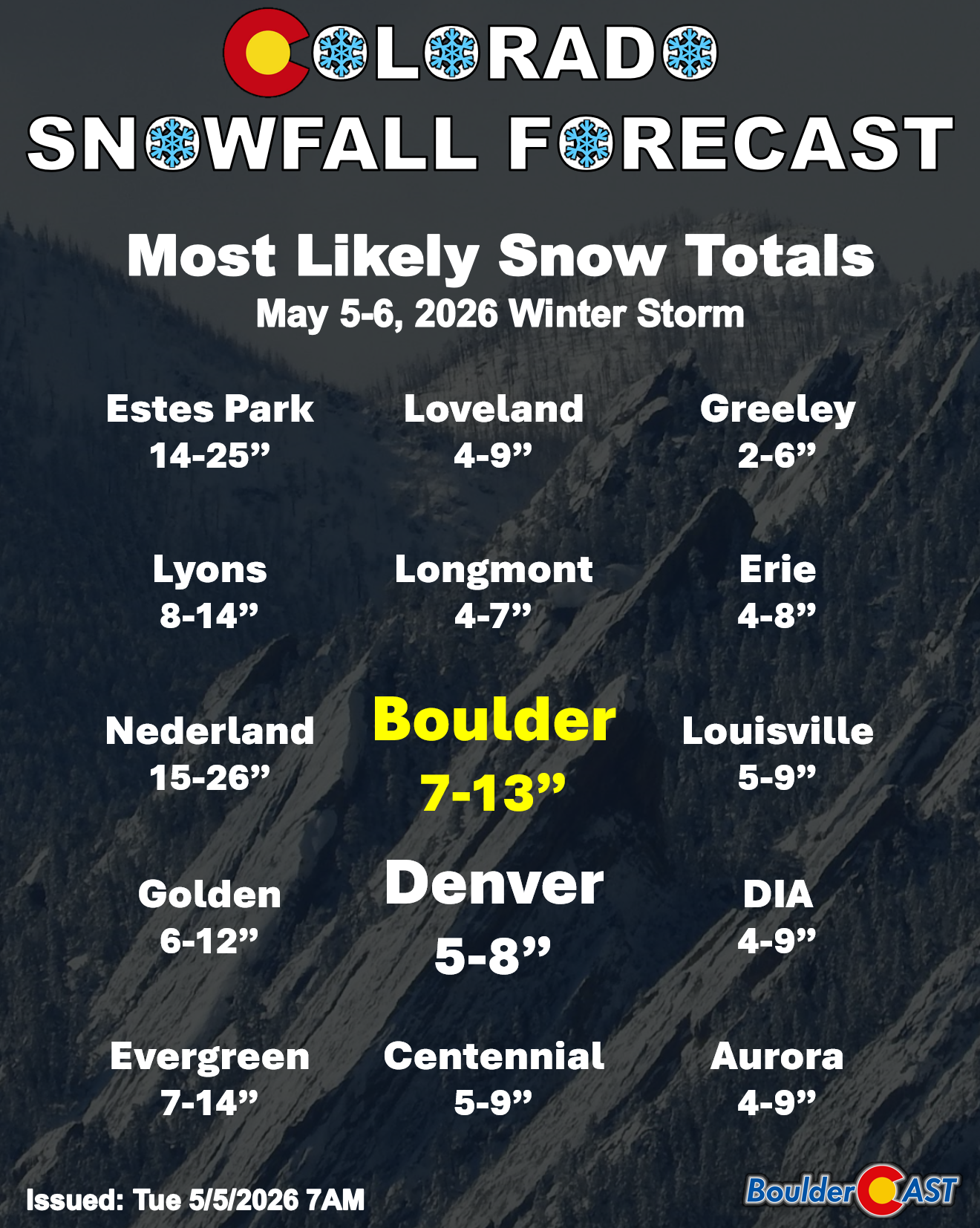
Finally, a few handpicked cities and their most likely forecast ranges. Whew!
Significant Impacts on Trees and Power Infrastructure
This storm’s biggest negative impact will be on the trees and power lines. With vegetation nearly fully leafed out, wet, adhesive snow will cling to branches and accumulate rapidly. Widespread limb breakage is likely, and power outages may become significant across the Metro area — both from falling limbs and snow loading on the lines themselves. Even the Foothills may see issues where aspen groves are already leafed out.
Outages could begin as early as late Tuesday evening and persist into Wednesday afternoon. If you have trees you care about, gently shaking snow off branches intermittently overnight and Wednesday can help reduce damage. It’s still going to be rough to keep up with the snow tonight on any bigger trees. It’s also best to park any cars well away from the any leafed-out trees!
For context: our last notable May snowstorm — which was less intense than this one — knocked out power to more than 100,000 Xcel customers in the Denver area, with Boulder among the hardest hit after receiving 8 inches of snow.
Travel impacts will be limited Tuesday due to the strong May sun, though slush may develop in the Foothills and Mountains. The main travel window of concern is Tuesday night into Wednesday morning, when heavy snow falls under the cover of darkness. Warm road temperatures will help, but snowfall rates will likely exceed melt rates, producing slushy, deeply sludgy conditions on untreated roads. Expect the worst conditions above 5,500 feet elevation and anywhere in Boulder. Roads will improve steadily Wednesday despite continued snowfall.
Finally, make sure you are prepared for the hard freezes coming Tuesday and especially Wednesday nights. Minimum temperatures are currently forecast to drop into the middle 20s Wednesday night after the storm pulls out, but that could trend colder in some areas. The Foothills will certainly be in the teens.
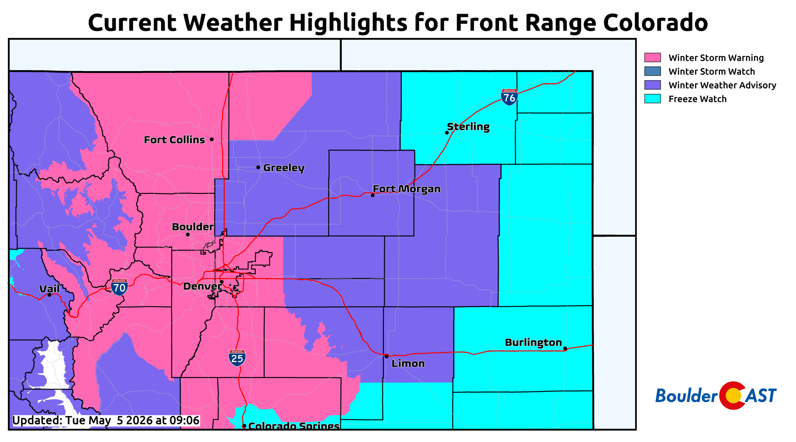
Winter Storm Warnings are in effect for much of the area, starting at 12PM Tuesday in the higher terrain and at 8PM across the Boulder-Denver area. These warnings run through 3PM Wednesday when the heaviest of the snowfall is expected to be in the rearview mirror. Freeze Watches are also in effect everywhere below 6000 feet for Wednesday night in anticipation of a widespread hard freeze.
Bottom Line
This storm arrives against the backdrop of a deepening drought that has tightened its grip on the Front Range for more than six months. Boulder and Denver Counties now sit at 100% Extreme Drought, something we haven’t seen since 2012 — a year remembered for rapid spring drying and intense fire activity.
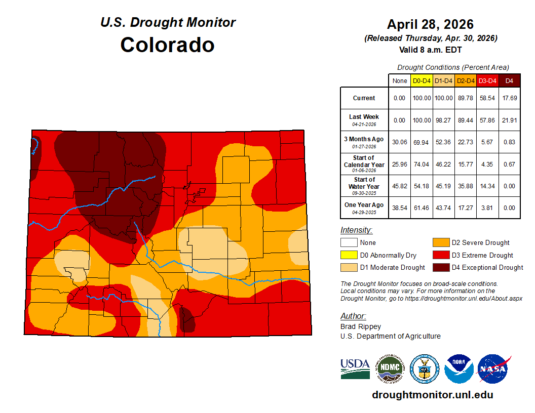
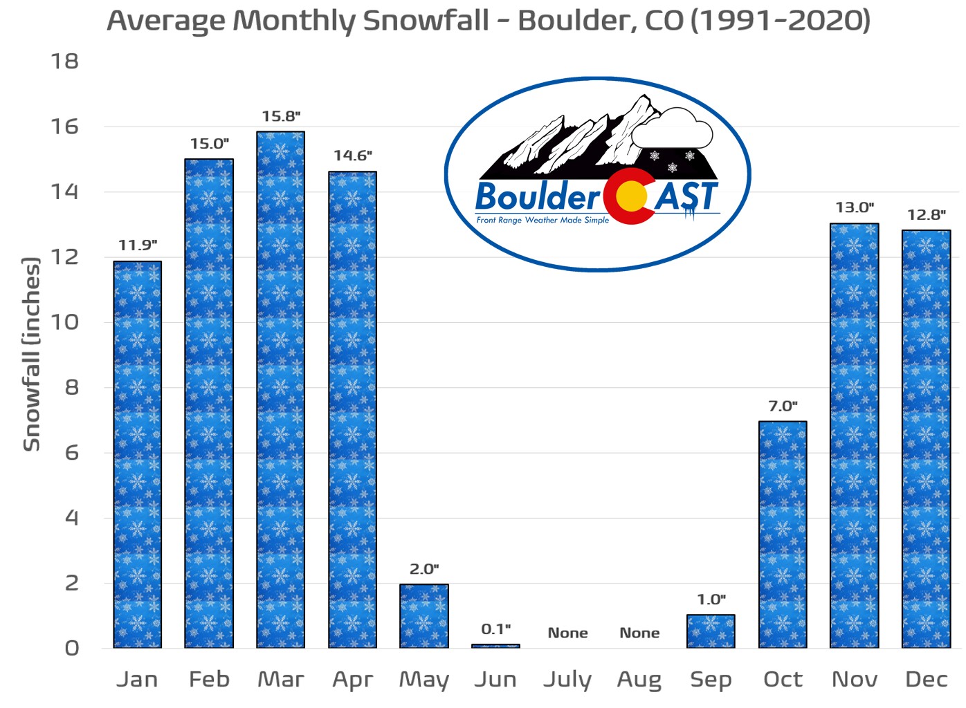
From a climatological standpoint, late‑season storms with substantial moisture aren’t unusual for Boulder. May is our wettest month, and May snowfall is part of our identity. But storms of this magnitude — deep upslope, cold air, heavy wet snow, widespread tree damage — fall into a more elite category, comparable to the impactful May events of 2019 and 2022. The combination of significant moisture, heavy snow, and a fully leafed‑out landscape weeks ahead of schedule elevates the risk.
Boulder’s largest May snowstorms
- 23.0″ – May 5-6, 1978
- 12.3″ – May 1-2, 2013
- 8.7″ – May 25, 1950
- 8.3″ – May 20-21, 2022
- 6.8″ – May 11-12, 2014
Mother Nature is giving us a rare opportunity for drought relief, but unfortunately it comes gift-wrapped inside a high‑impact, damaging spring storm, one that will leave a mark on both our reservoirs and our trees.
Spread the word, share our crazy Colorado weather:
Go Premium, get all the perks.
Daily Forecast Updates
Get our daily forecast discussion every morning delivered to your inbox.
All Our Model Data
Access to all our Colorado-centric high-resolution weather model graphics. Seriously — every one!
Ski & Hiking Forecasts
6-day forecasts for all the Colorado ski resorts, plus more than 120 hiking trails, including every 14er.
Smoke Forecasts
Wildfire smoke concentration predictions up to 72 hours into the future.
Exclusive Content
Weekend outlooks every Thursday, bonus storm updates, historical data and much more!
No Advertisements
Enjoy ad-free viewing on the entire site.


You must be logged in to post a comment.