


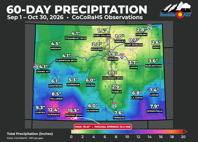
After months of worsening drought, southwest Colorado has flipped the script in dramatic fashion this fall. From Pagosa Springs to Durango to the entire San Juans, some locations have picked up an astonishing 15 to 20 inches of precipitation in just 60 days, erasing extreme drought conditions but ultimately triggering one of the region’s most significant flood events on record. What turned a parched landscape into a flood disaster in only eight weeks? We dive into the remarkable sequence of tropical moisture surges, the key role of a strengthening record El Niño, and why the same pattern that drenched southwest Colorado left Boulder and Denver largely high and dry.
What You Need to Know
Drought Erased in Just 8 Weeks: Southwest Colorado went from some of the state’s worst drought conditions in early September to near drought-free by late October after a barrage of rain and mountain snow.
Rainfall for the Record Books: Pagosa Springs and surrounding Archuleta County picked up 15-19 inches of precipitation in just 60 days, with one gauge measuring 19.41″, more than many Front Range locations receive in an entire year.
From Drought to Destructive Flooding: Four major storm periods repeatedly soaked already saturated ground, culminating in late-October flooding that produced the second-highest San Juan River crest on record and widespread damage across southwest Colorado.
Tropical Moisture Did the Heavy Lifting: Remnants of multiple eastern Pacific hurricanes, combined with a strong El Niño and favorable storm track, repeatedly funneled deep moisture into the San Juans where terrain-enhanced rainfall maximized totals.
Colorado’s Weather Divide: While the San Juans saw dramatic drought improvement and historic precipitation, Boulder, Denver, and much of northern Colorado remained largely dry, with drought conditions seeing little to no improvement.

Go Premium, get all the perks.
Daily Forecast Updates
Get our daily forecast discussion every morning delivered to your inbox.
All Our Model Data
Access to all our Colorado-centric high-resolution weather model graphics. Seriously — every one!
Ski & Hiking Forecasts
6-day forecasts for all the Colorado ski resorts, plus more than 120 hiking trails, including every 14er.
Smoke Forecasts
Wildfire smoke concentration predictions up to 84 hours into the future.
Exclusive Content
Weekend outlooks every Thursday, bonus storm updates, historical data and much more!
No Advertisements
Enjoy ad-free viewing on the entire site.
A
t the start of September, like much of the state, southwest Colorado was parched. Around Durango, Pagosa Springs and the San Juan Mountains, drought had dragged on for months, and parts of the high country were in the worst drought category on the map.
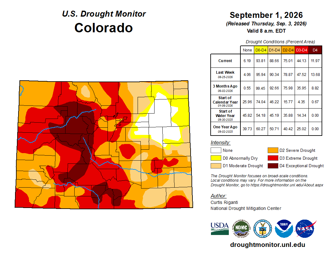
Eight weeks later, that drought is almost completely gone. Storm after storm, many of them fueled by moisture from recurving Pacific hurricanes fueled by the warmth of an extreme El Niño, soaked the region with rain and high-elevation snow. It has been one of the wettest autumns southwest Colorado has ever seen, but it came at a price: a destructive flood that swept through Pagosa Springs and other Colorado towns in the second half of October.
Up to 19 Inches in 60 Days
Here’s how much precipitation has fallen across Colorado since September 1st.
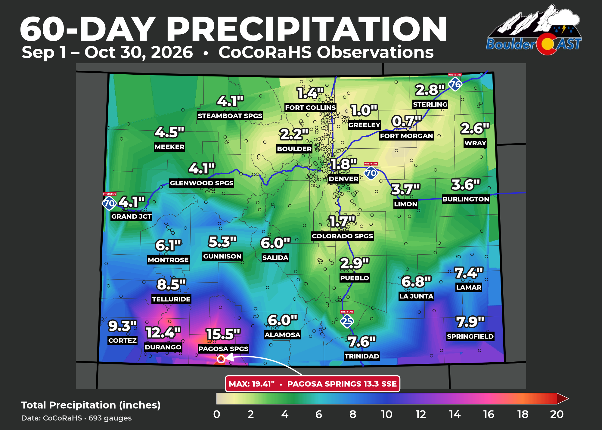
The bullseye sits right over Pagosa Springs and Archuleta County. Gauge after gauge there measured 15 to 19 inches, and the top report, 13 miles SSE of town, reached 19.41″. That’s more than most of the Denver Metro area typically sees in an entire year, and it fell in two months. Durango, Bayfield, Hermosa and Hesperus weren’t far behind, with many totals of 12 to 15 inches.
Now compare the regions:
- Typical total in southwest Colorado: 13″
- Typical total in the Denver–Boulder area: 2″
That’s more than six to one. The far southeast plains of Colorado also did surprisingly well, too, with several gauges in Baca and Las Animas counties topping 10 to 12 inches. More on that later.
This wasn’t one storm. Southwest Colorado saw four distinct wet periods over the last two months:
- September 14–18: several days of repeated heavy showers and thunderstorms, fueled by a prolonged monsoon season, with the wettest gauges picking up 2 to 3 inches in a single day
- September 23 – October 1: capped by a surge of moisture from Hurricane Polo and the remnants of Hurricane Odalys.
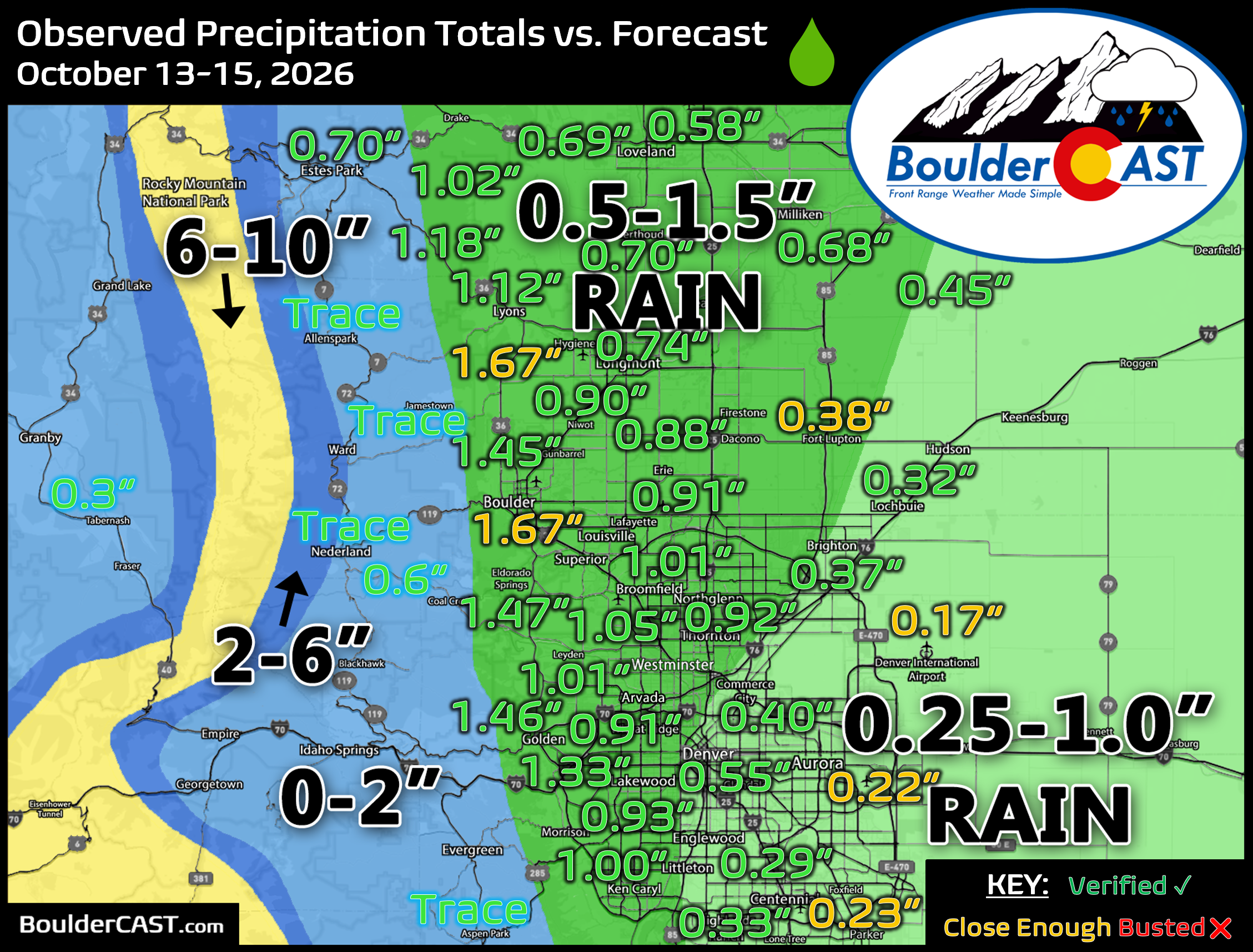
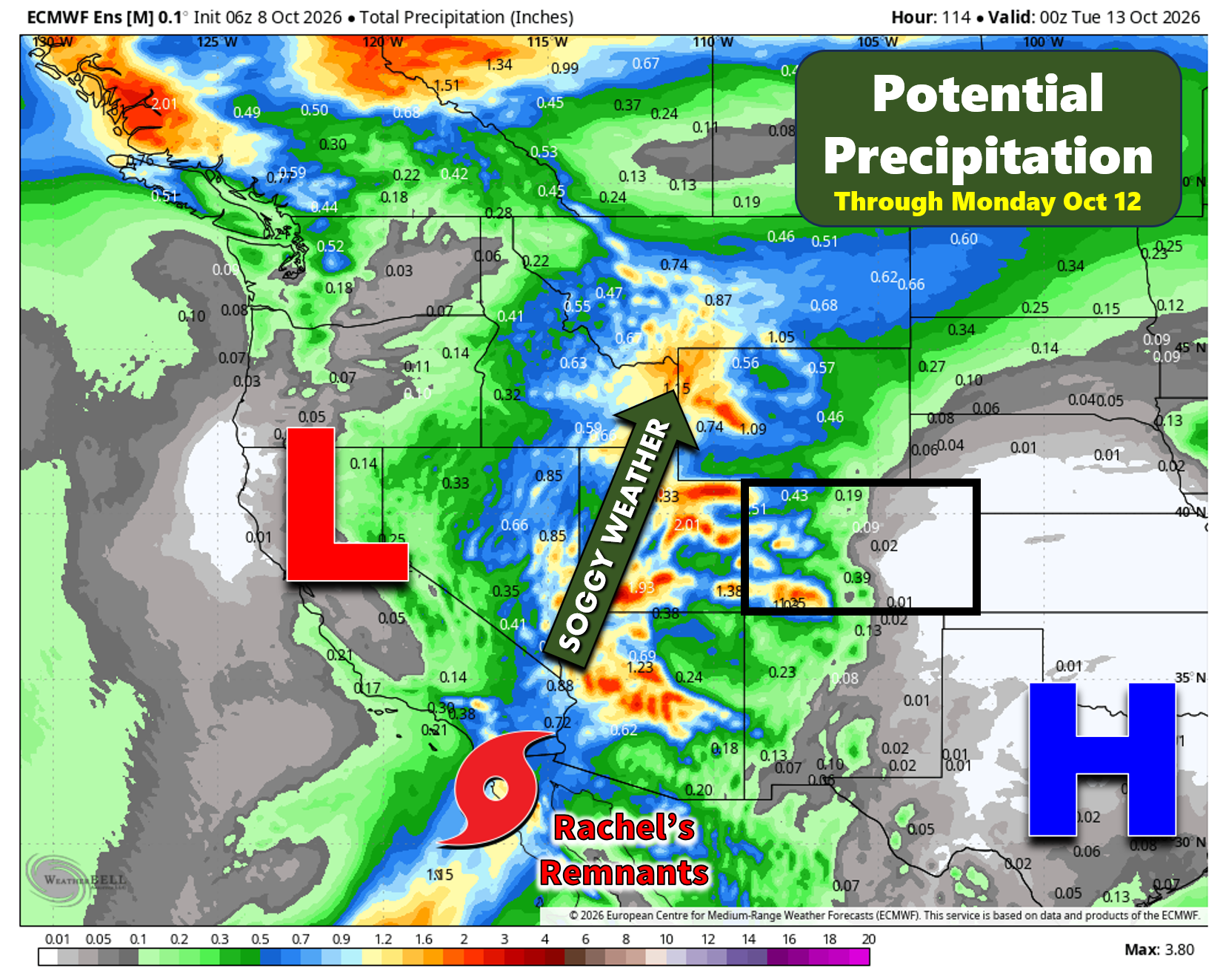
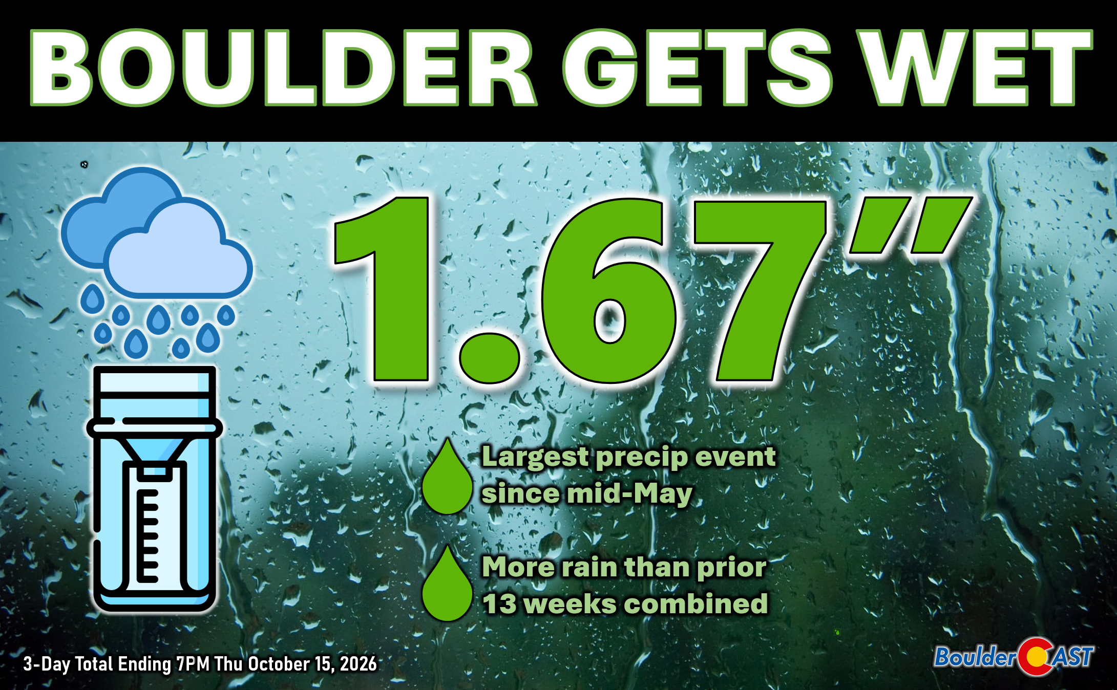
- October 12–15: a slow, chilly storm that buried the high peaks in fresh snow and soaked the valleys. This included the remnants of Hurricane Rachel.
- October 21–25: the big one, fueled by the remnants of Hurricane Trudy. Many Pagosa-area gauges reported more than 3 inches on October 23 alone.
Every round fell on ground the previous one had already saturated. That’s how you go from drought to flood in a matter of weeks.
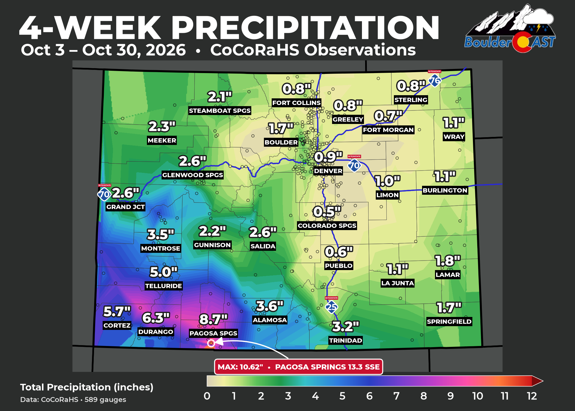
The Last Four Weeks Alone
Narrow the window to just the last four weeks and the pattern holds. The rain kept targeting the same corner of the state:
The Flood
The Trudy event pushed things over the edge.
- The San Juan River at Pagosa Springs rose about 9.5 feet in 34 hours and crested at 15 feet early on October 23. That’s the second-highest crest on record, behind only the legendary October 1911 flood (17.2 ft).
- In Archuleta County alone, about 540 homes were damaged. Roughly 150 miles of county roads were impassable, and Colorado 151 collapsed in two places.
- Wolf Creek Pass closed after a culvert failure opened a sinkhole in US 160.
- The San Luis Valley had its wettest two-day period on record: Del Norte 2.74″, Monte Vista 2.56″ and Alamosa 2.11″. Alamosa’s previous record was set in 1959.
- Durango broke its all-time October precipitation record.
- The state’s flood disaster emergency now covers 12 Colorado counties, and flooding continued downstream into Farmington, NM and Bluff, UT.
One cruel detail made it worse. The mid-October storm left fresh snow on the high peaks. Trudy’s remnants were warm, so it rained even at very high elevations. Rain on top of that snow, on ground that was already soaked, sent runoff surging.
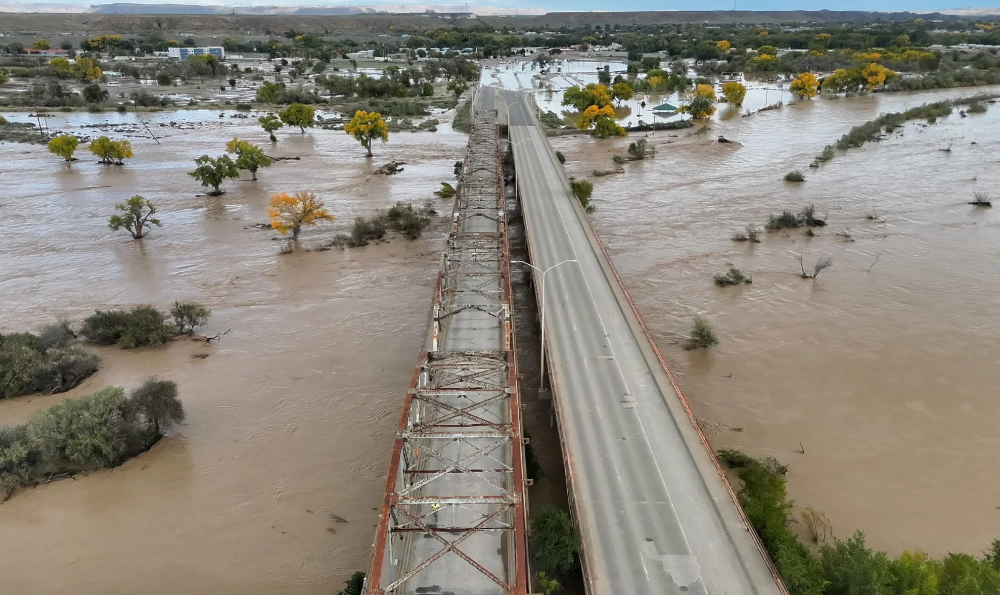
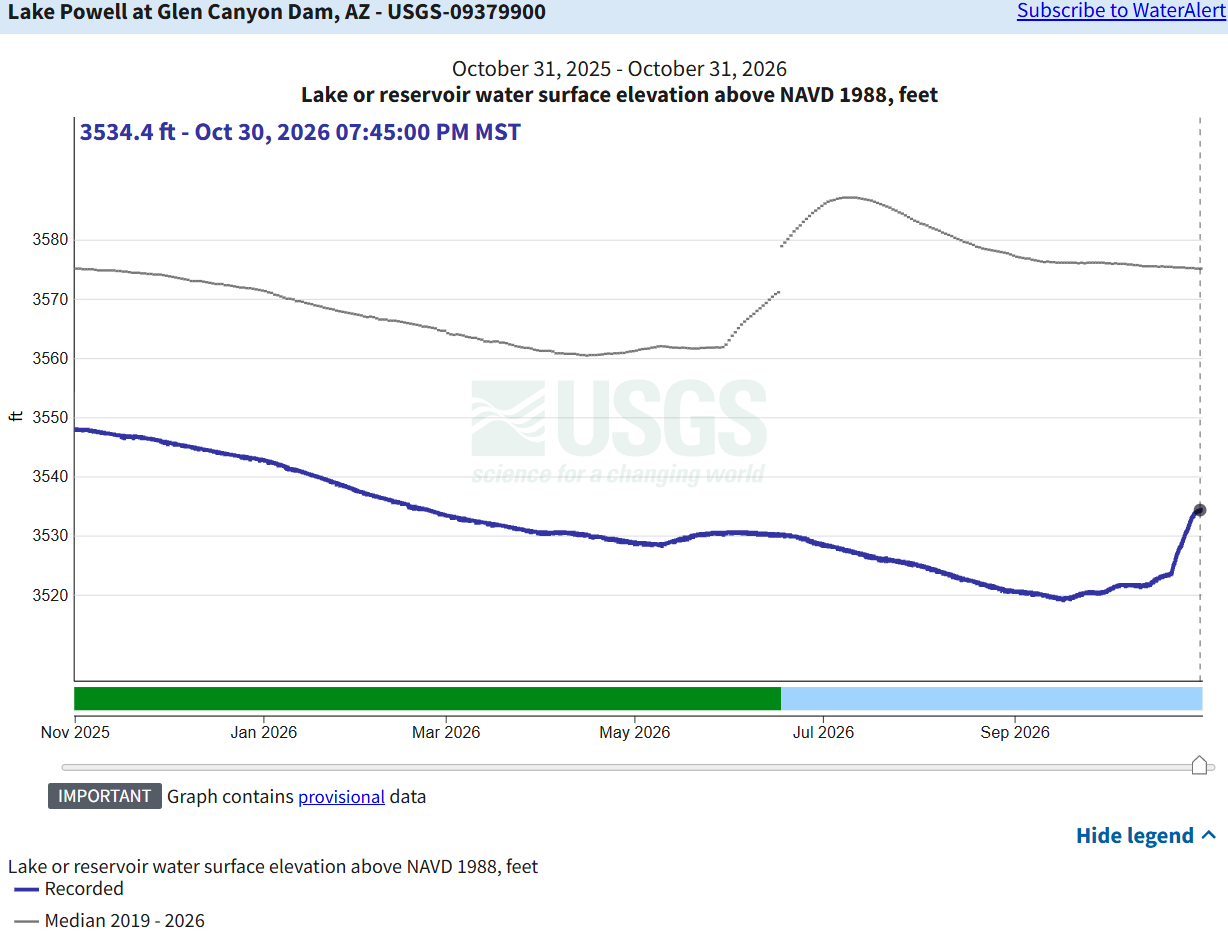
There’s at least one bright spot. Navajo Reservoir took in roughly 266,000 acre-feet of water, and Lake Powell rose about ten feet in the last two weeks. It’s also worth noting that this is the second October in a row that a tropical-remnant flood has hit Pagosa Springs. The October 2025 flood, fed by the remnants of Priscilla and Raymond, ranked as the third-largest on record there.
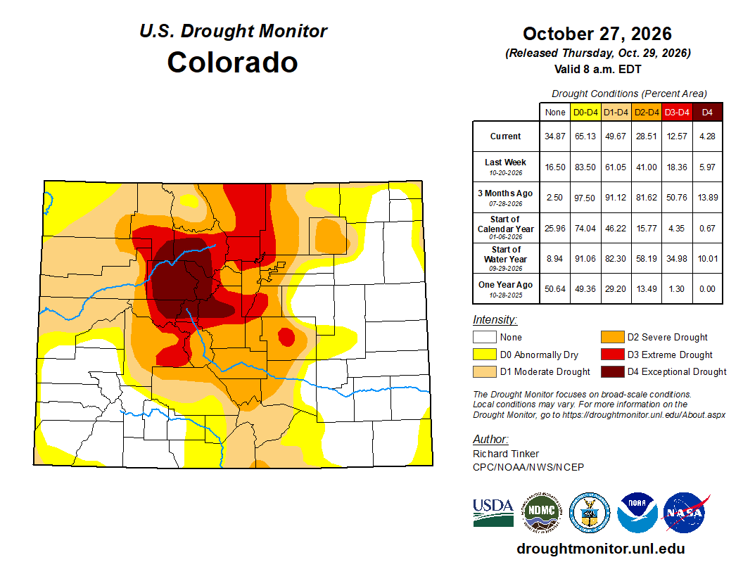
The Drought: Before and After
Here’s the U.S. Drought Monitor for Colorado on September 1 and October 27 showing remarkable improvement across much of Colorado, particularly in the San Juans.
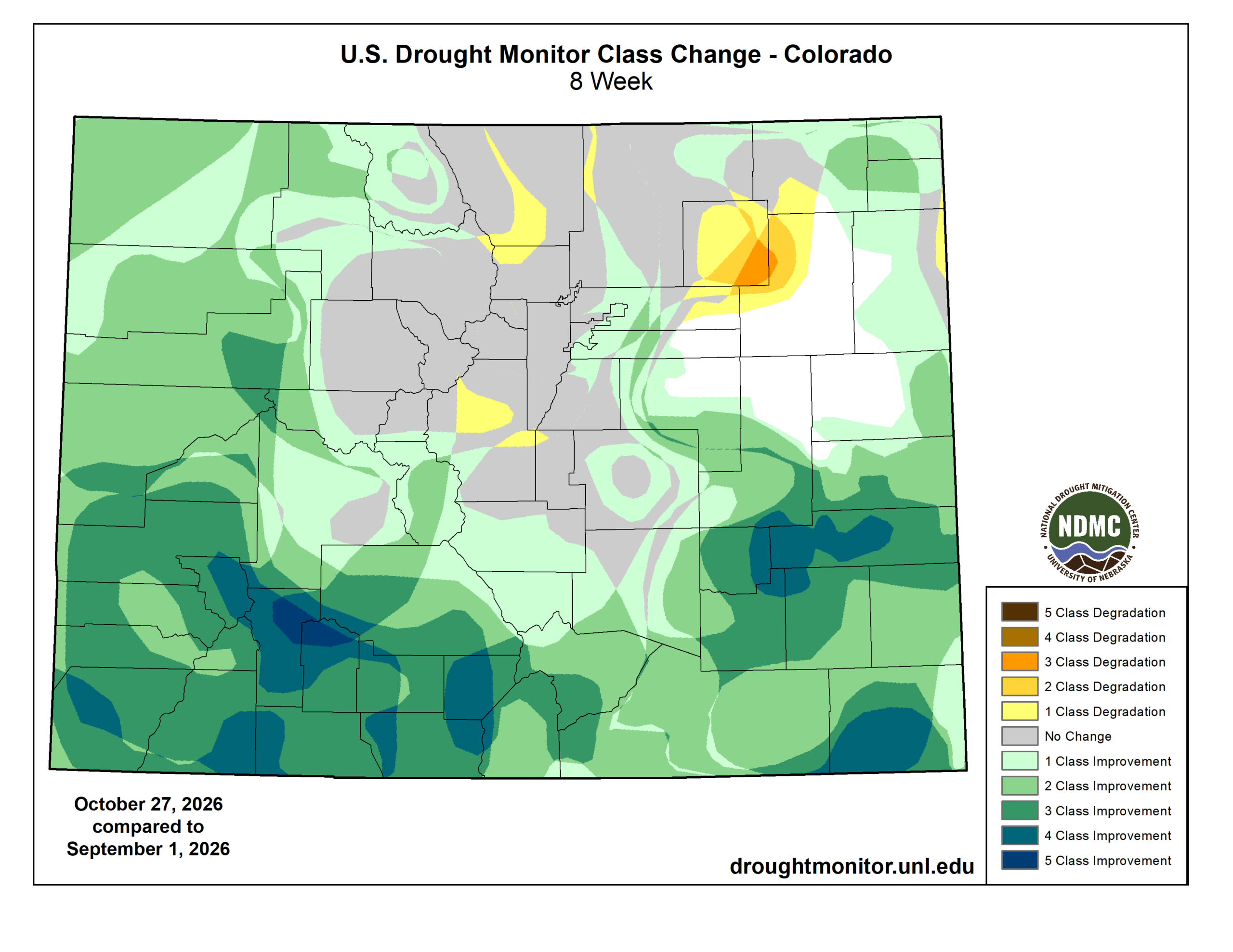
The 8-week change map shows the contrast best. Deep greens and blues, meaning three-, four-, even five-category improvements, cover the San Juans and southeast Colorado. Something no one thought possible in a year that has been so dry. Along the Front Range, the northern mountains and much of the I-25 corridor, the map is mostly gray, meaning no change at all. Parts of northeast Colorado actually got worse.
Much of that improvement came in the last month. Since September 29, statewide coverage of Severe Drought or worse has been cut in half. The final Trudy-driven update came on October 27, and in that one week the share of Colorado with no drought at all more than doubled, from 16% to 35%.
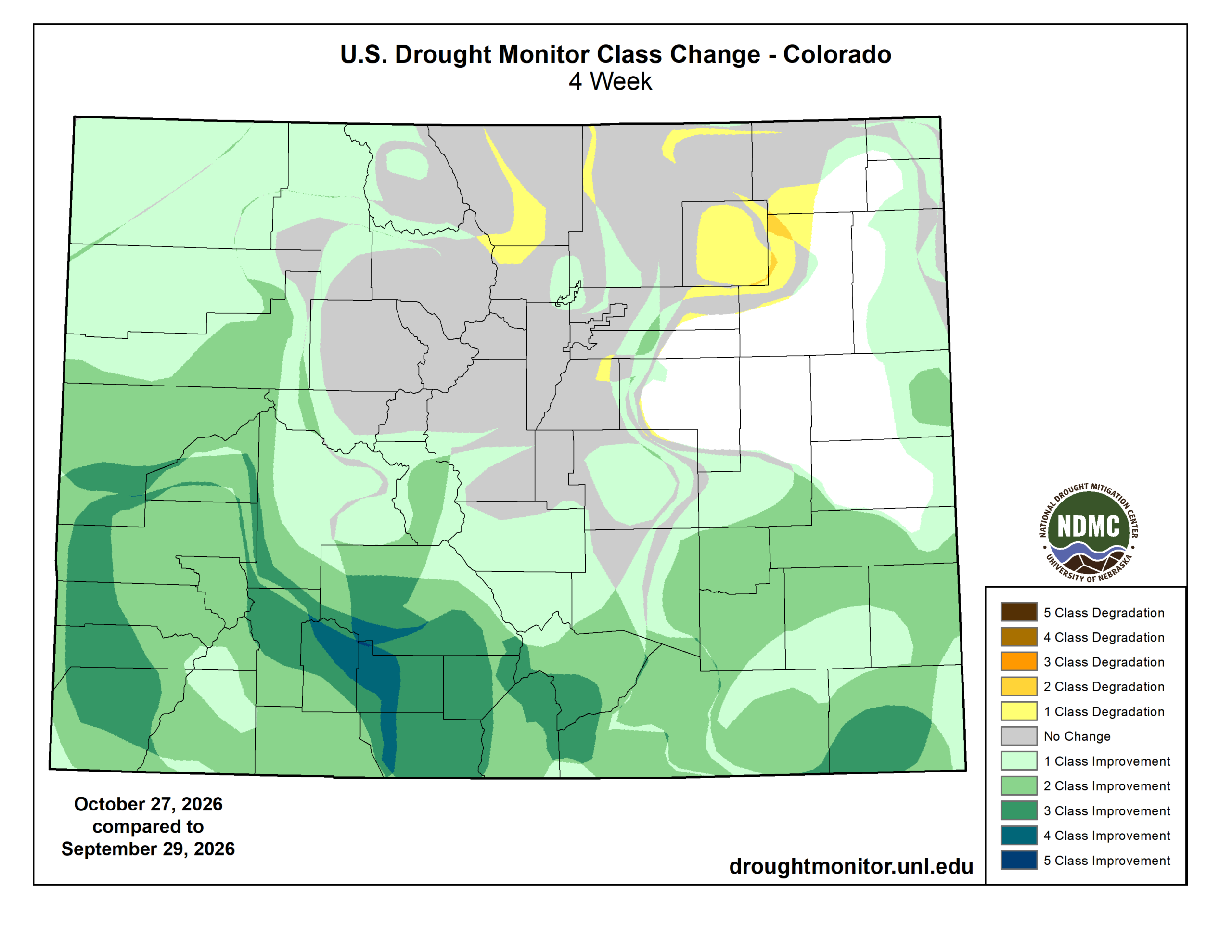
And for us? Boulder County went from 85% Extreme Drought (D3) on September 1 to 100% D3 today. The core of Exceptional Drought over Grand, Summit and Eagle counties hasn’t budged. With the exception of the mid-October event that dumped on Boulder and Larimer Counties, northern Colorado got almost none of this pattern’s rain or snow..
Why the San Juans? The Setup That Kept Repeating
This fall ran the same basic recipe again and again:
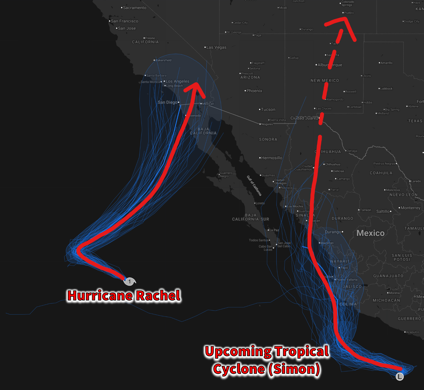
1. Plenty of tropical moisture from a hyperactive eastern Pacific. The 2026 eastern Pacific hurricane season has been relentless late in the year. Odalys, Polo, Rachel, Simon and Trudy churned off Mexico from late September through mid-October, and Polo and Trudy both became major hurricanes. When these storms weaken over cooler water near Baja or along Mexico’s west coast, their deep moisture doesn’t just disappear. The winds aloft pick it up and carry it north. This was a critical ingredient of the exceptionally wet autumn in the Four Corners.
2. A West Coast trough to pull it north. Each event needed one more ingredient: an upper-level trough or slow-moving low over California or the Great Basin. And that’s exactly what we got. Ahead of that trough, south-southwesterly flow set up a conveyor belt from the subtropical Pacific straight into the Four Corners. During the Polo event, a trough over California did exactly that, drawing the moisture and lift right into the region. During these surges, the atmosphere held 150 to 350% of the normal amount of moisture (i.e. precipitable water).
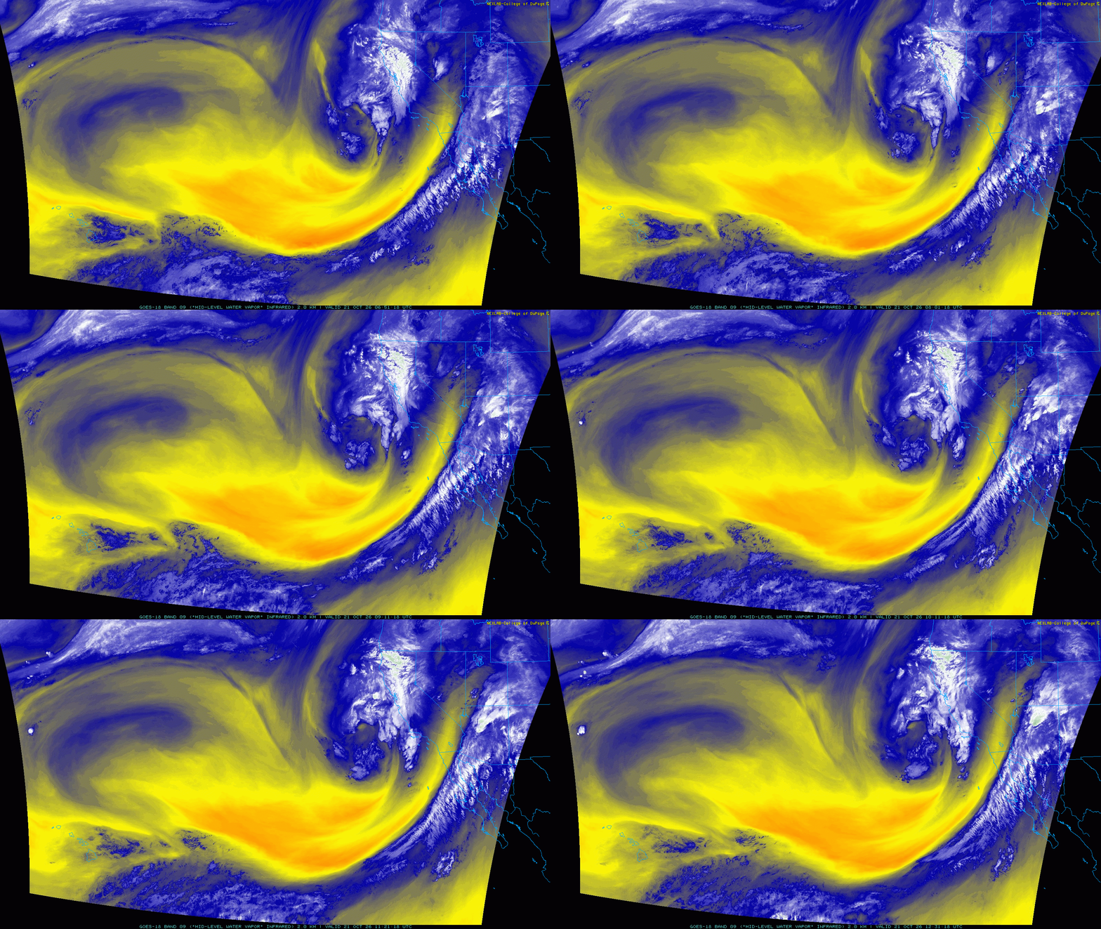
3. The San Juans are the first wall in the way. This is the crucial piece. In south-southwesterly flow, the south-facing slopes of the San Juans are the first major high terrain the moist air hits after crossing Arizona and New Mexico. Wolf Creek Pass, Pagosa Springs, Vallecito and the Animas Valley sit right in that upslope zone. The mountains force the air upward and wring out the moisture very efficiently. That’s why the bullseye on precipitation maps lines up so neatly with the southern San Juans.
4. Slow-moving storms = repeated rounds of soaking precip. Several of these troughs stalled or cut off, so the moisture plume stayed aimed at the same mountains for 24 to 48 hours or more instead of moving through quickly.
Why the Front Range Missed Out
The southwest flow that’s so good for the San Juans is just about the worst pattern there is for us here in Boulder and Denver:
- We’re downwind of the Continental Divide. By the time air from the southwest reaches us, it has crossed the San Juans, the Sawatch and the Front Range. It has been lifted and dried out over and over, and then it sinks down the east side of the mountains. Sinking air warms and dries, which shuts down rain. That’s a rain shadow, and southwest flow puts us right in it.
- No upslope. Big rain and snow events on the Front Range need easterly upslope flow, usually from a strong high pressure to our north or a well-placed low to our south and east. This fall’s pattern mostly lacked that. The mid-October storm came closest, and it gave the Metro area its only meaningful rain of the period, roughly three-quarters of an inch on average, though higher totals over 1.5 inches fell in parts of Boulder County.
- The moisture exited to the southeast. Much of the moisture that made it past the San Juans tracked across southern Colorado and New Mexico into the southern Plains. That’s why Baca and Las Animas counties did so well while areas north of the Palmer Divide stayed dry. Simon’s moisture, for example, fed flooding in Texas and the central Plains instead of heading our way.
So as you can, the very same weather pattern that drenched Durango and Pagosa Springs did almost nothing for Boulder and Denver this fall.
Enter El Niño
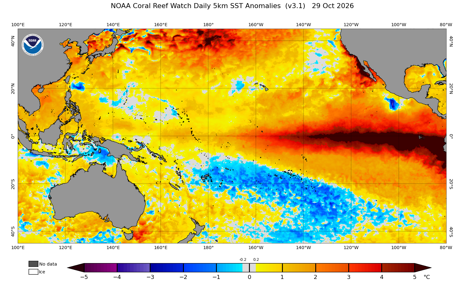
None of this recent wet weather has been happening in a vacuum. We’re in the middle of a very strong and still-strengthening El Niño. Weekly Niño-3.4 sea surface temperatures are running on average 2.5°C above normal, with a broad portion of the waters along the far eastern Pacific seeing anomalies greater than 5°C right now — that’s 9°F! The Climate Prediction Center puts the odds of a strong-to-very-strong event lasting through winter at better than 83%, and gives a sizable chance this becomes the strongest El Niño since records began in 1950.
How does that connect to rain in the San Juans?
- Warmer water fuels more eastern Pacific hurricanes. El Niño warmed the tropical eastern Pacific and tends to reduce the wind shear that tears storms apart, which favors an active season. This fall’s late-season parade of hurricanes fits that pattern.
- A more active subtropical jet stream. El Niño tends to strengthen the subtropical jet, sending more troughs into the Southwest. Those troughs are what pulled the tropical moisture north.
- El Niño autumns lean wet in the Southwest. Historically, fall precipitation across the Four Corners tends to run above normal during El Niño.
- A longer monsoon. As we noted back in September, the developing El Niño helped keep monsoon moisture flowing into the Four Corners well past its usual end.
One important caveat: El Niño doesn’t cause any single storm. It tilts the odds, and this fall it tilted them heavily toward southwest Colorado.
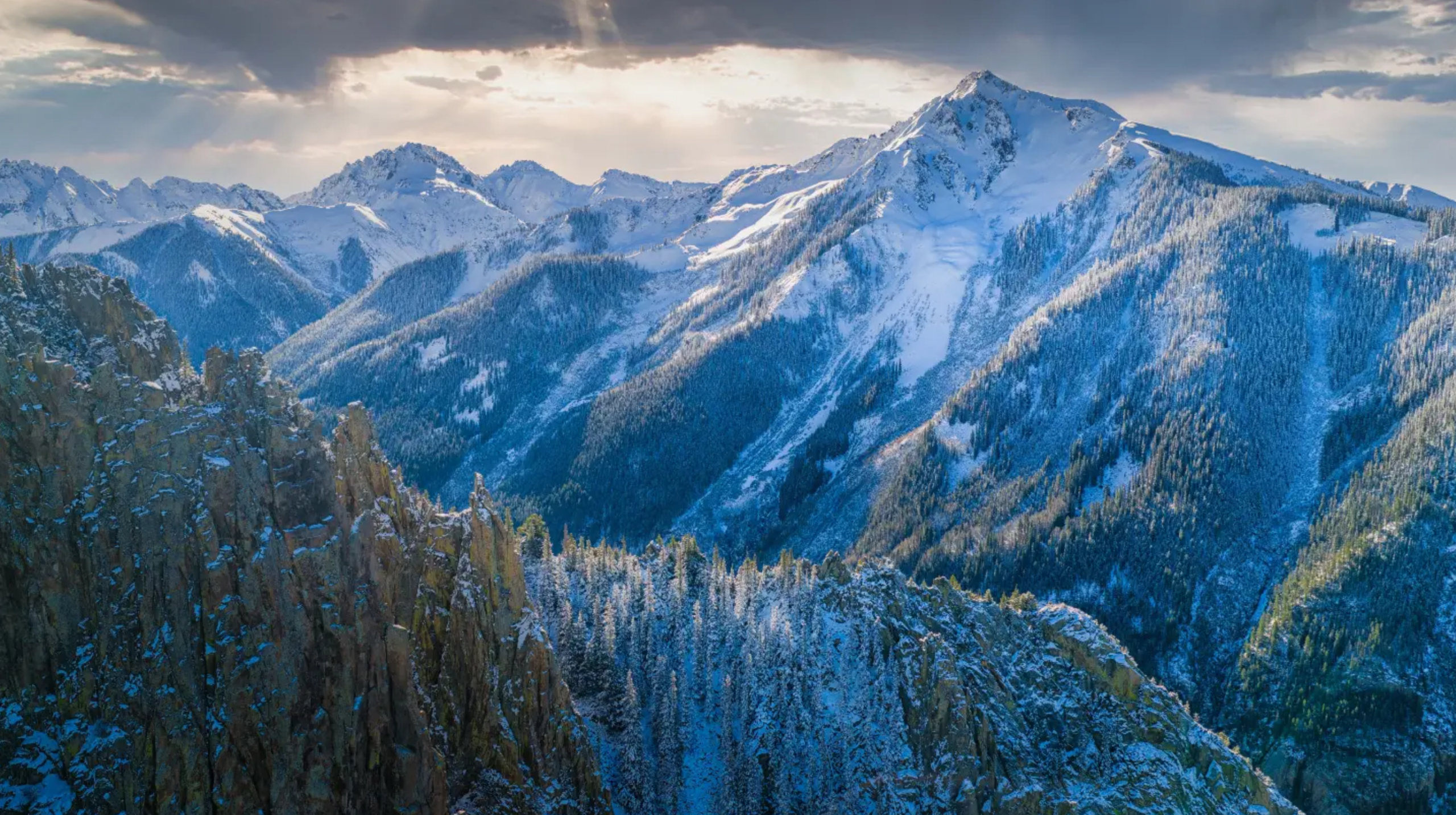
San Juans snow earlier in October. Photo credit: 998Millibar on Threads
What’s Next
It’s hard to believe, but there’s even more on the way. Another eerily similar, soaking storm is heading into the Four Corners to kick off November, with heavy rain and mountain snow set to unleash Sunday into Monday. Unlike most prior events, this one will exist without an injection of remnant-hurricane moisture. Instead, it’s getting juiced up by a healthy subtropical jet coming ashore from the Pacific.
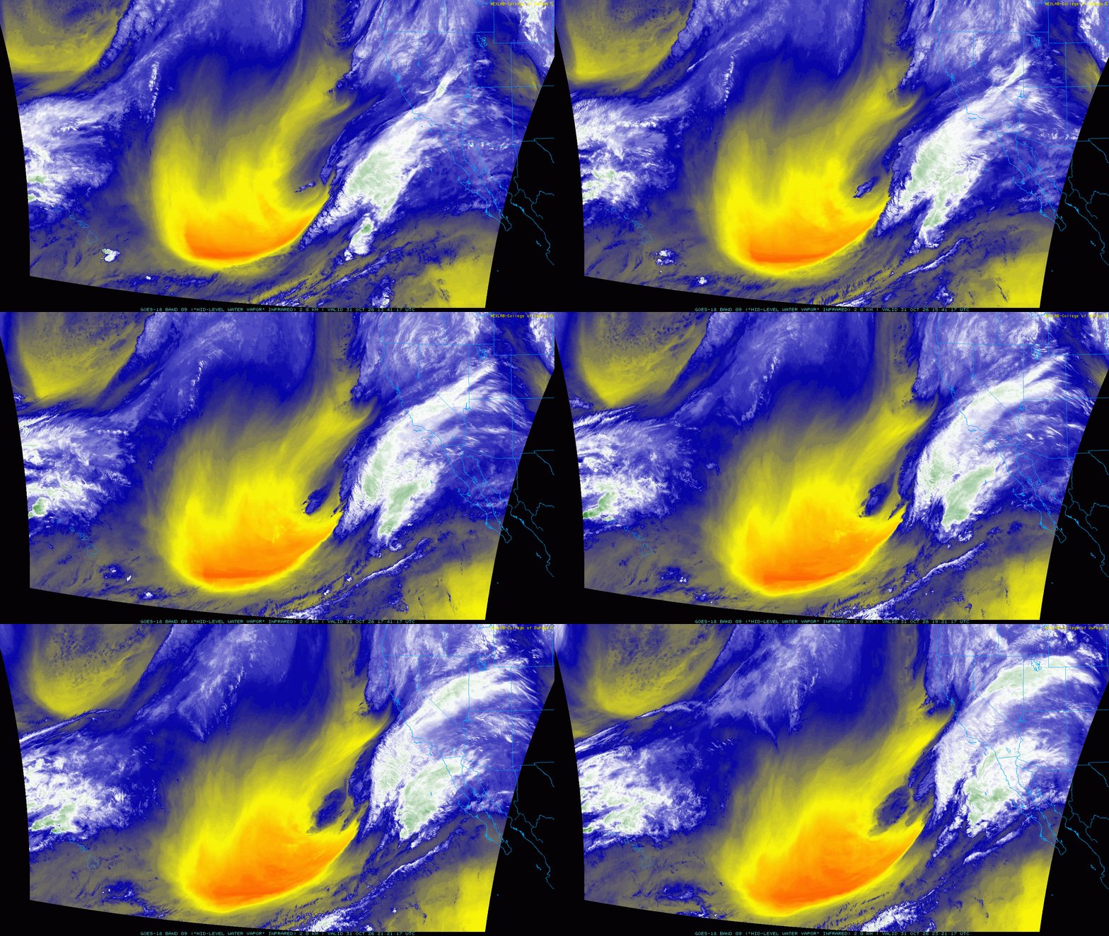
Pacific trough currently digging way south offshore from California, with subtropical moisture spreading into the Southwest.
The San Juans could pick up a foot or more of snow around Wolf Creek (which just opened its slopes today), while lower elevations face renewed flooding concerns from an anticipated widespread 2 to 4 inches of rain.
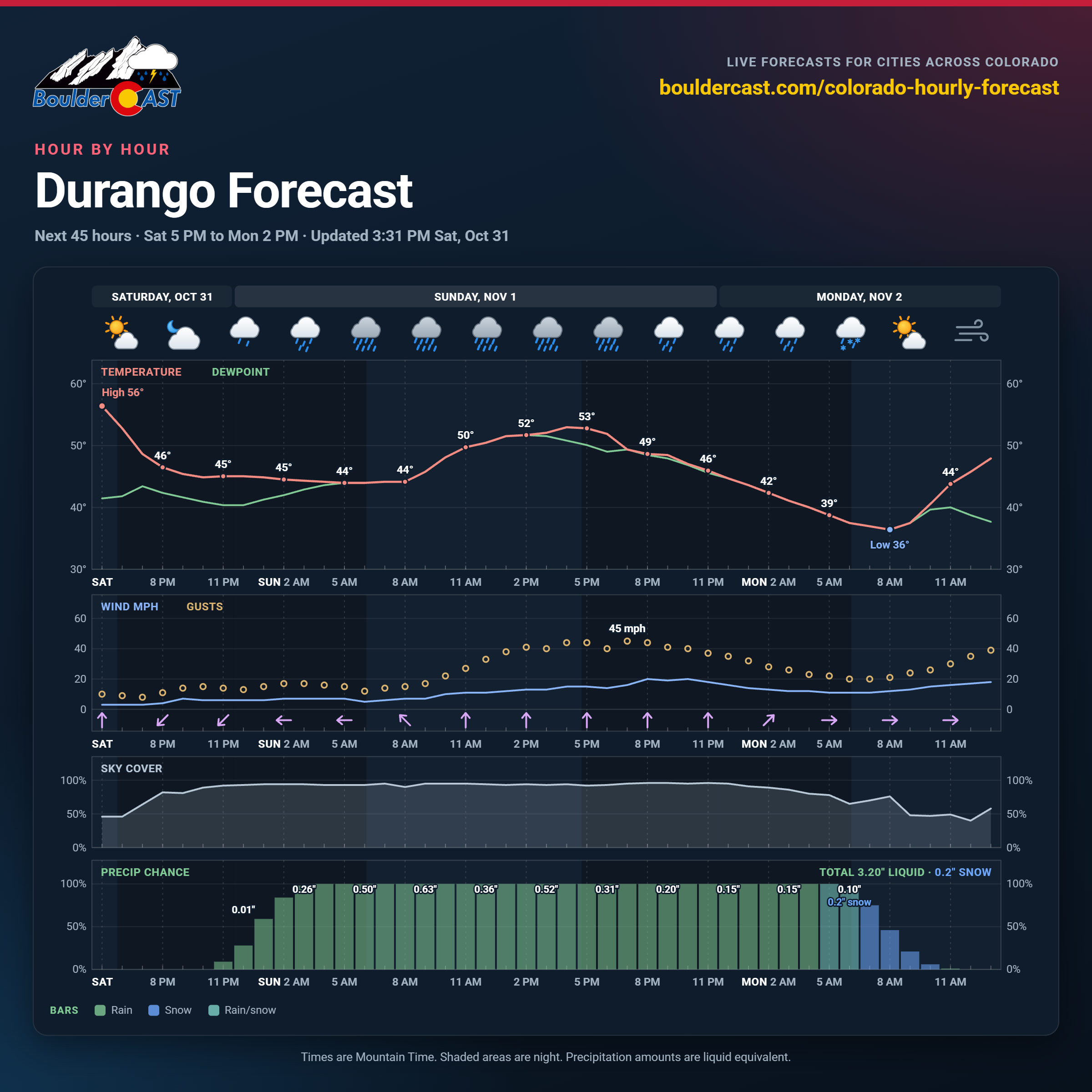
This system is colder, so at least the high country should get snow instead of rain this time, but we’re expecting to see more devastation from flooding and landslides at lower elevations.
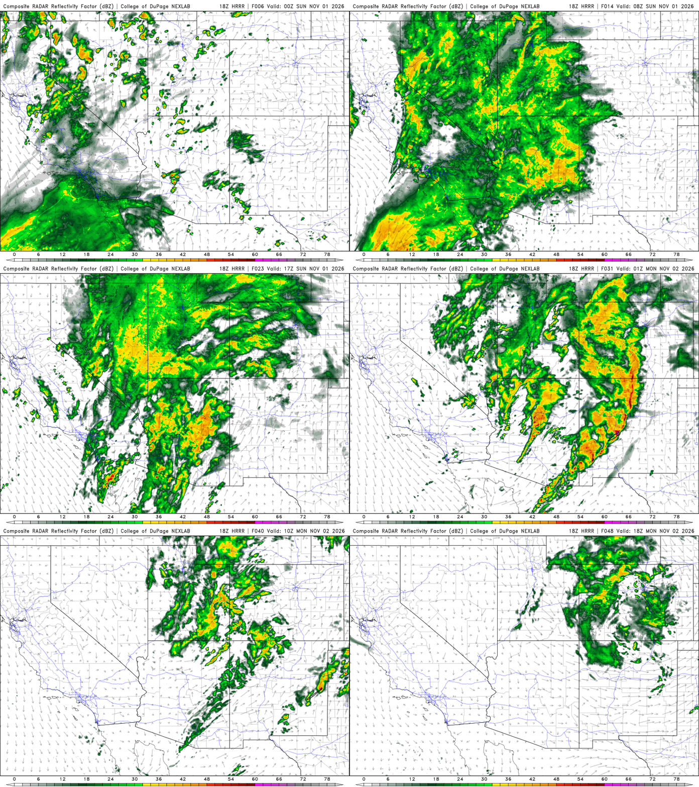
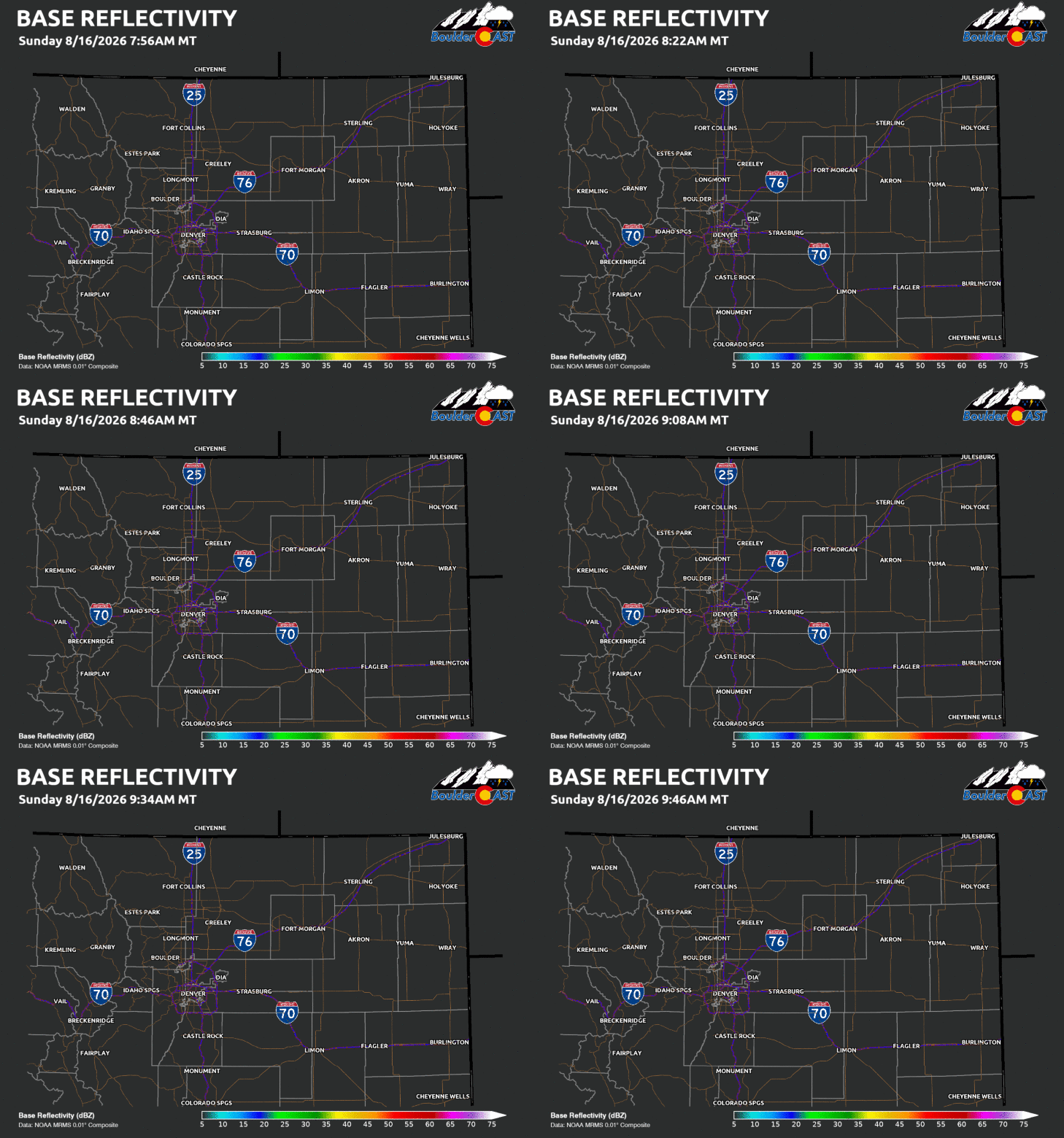
Simulated radar animation of the early November storm as it rakes across the Four Corners and brings widespread precipitation for a couple days.
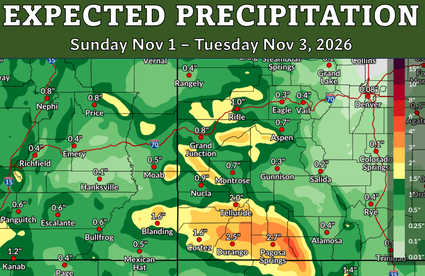
As usual, the Front Range will largely miss out on this event. Model blends have a very aggressive donut hole void with no precipitation over the northern I-25 Corridor, with Boulder and Denver struggling to pick up a few hundredths of an inch of rain Monday into Tuesday.
For the Front Range, the big question is whether this historic El Niño eventually works in our favor. Strong El Niño winters have historically been a mixed bag for Boulder and Denver, but the spring months during El Niño tend to bring our biggest upslope storms, with drier conditions throughout the heart of winter. With our entire area in Moderate to Extreme Drought, we could really use them.
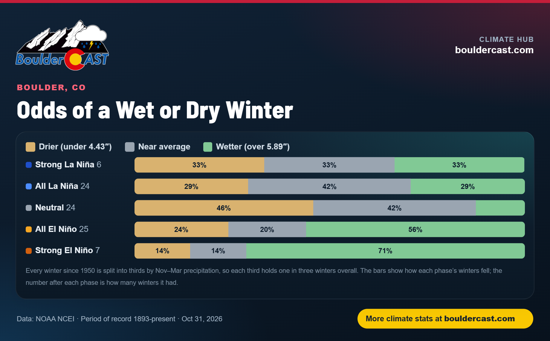
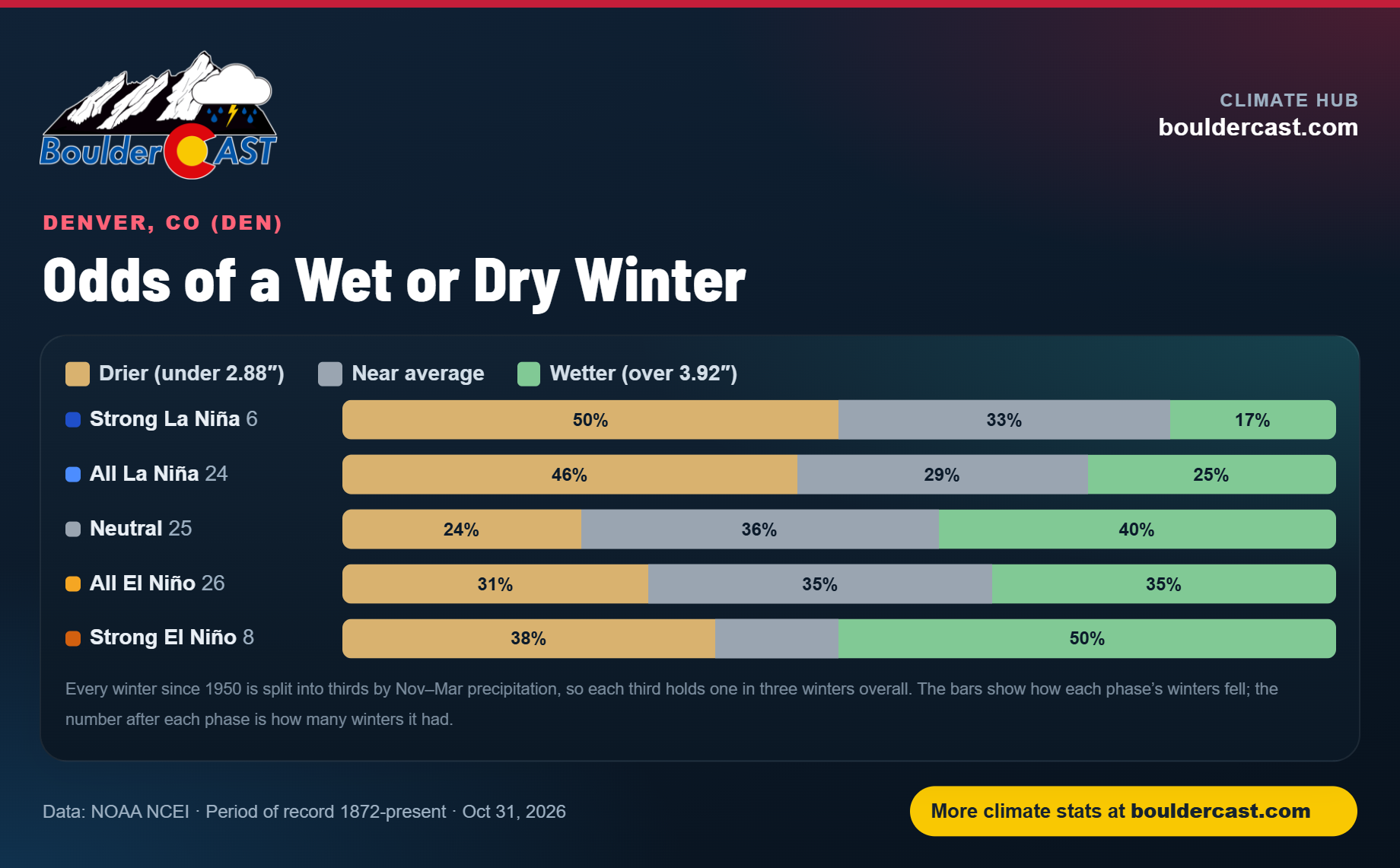
For now, southwest Colorado has gone from desperately needing rain to desperately needing a break from it. The Front Range, meanwhile, remains stuck on the sidelines, watching one of the most remarkable weather reversals in recent Colorado history unfold hundreds of miles away. And with another profound storm already on the state’s doorstep, this extraordinary chapter may not be finished yet.
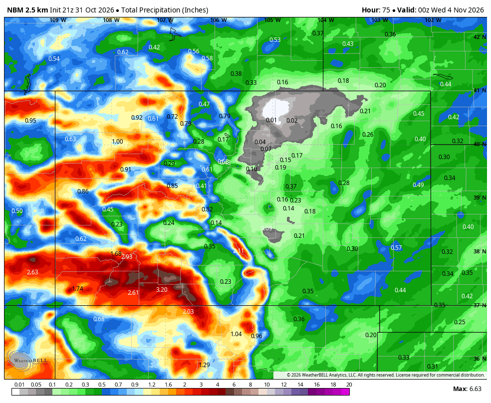
Blended precipitation forecast through Tuesday November 3rd in Colorado. Lovely donut hole over Denver, eh?
Spread the word, share our crazy Colorado weather:
Go Premium, get all the perks.
Daily Forecast Updates
Get our daily forecast discussion every morning delivered to your inbox.
All Our Model Data
Access to all our Colorado-centric high-resolution weather model graphics. Seriously — every one!
Ski & Hiking Forecasts
6-day forecasts for all the Colorado ski resorts, plus more than 120 hiking trails, including every 14er.
Smoke Forecasts
Wildfire smoke concentration predictions up to 84 hours into the future.
Exclusive Content
Weekend outlooks every Thursday, bonus storm updates, historical data and much more!
No Advertisements
Enjoy ad-free viewing on the entire site.





Leave a Reply
You must be logged in to post a comment.