


Despite an active monsoon that refuses to quit, Boulder has remained stubbornly dry with just 18% of normal precipitation during September which has been anything but typical. This week will keep the theme alive: plenty of monsoon flow, impressive moisture surges, and even a pair of dancing hurricanes in the Eastern Pacific, yet northern Colorado will still struggle to squeeze out meaningful rainfall again. We break down why the pattern looks so active on paper, why the Front Range keeps missing out, and what late‑week changes might finally nudge storm chances upward.
This week’s highlights include:
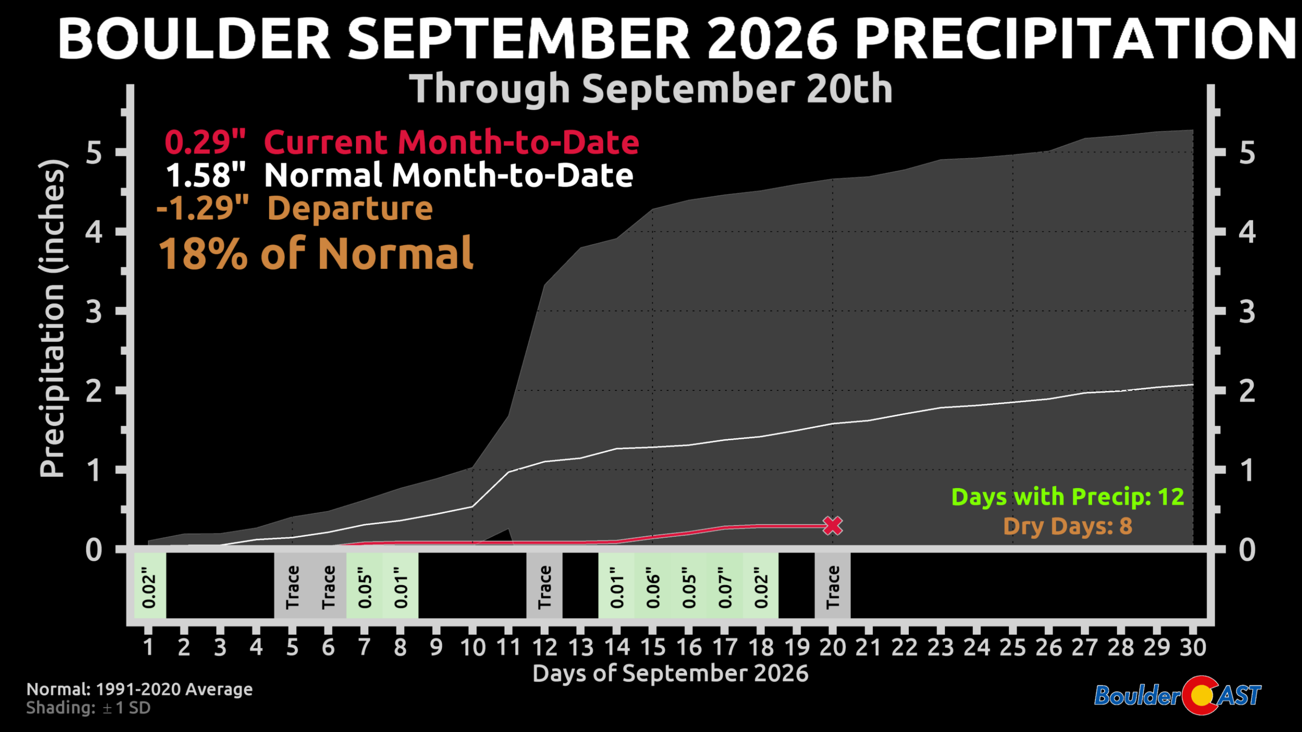
- 🌧️ El Niño keeps the late-season monsoon alive, but Boulder has remained stubbornly dry with just 0.29″ this month (18% of normal).
- 🌩️ Monsoon pattern will stay active but stingy, with southwest flow, weak ridging, and limited lift all week despite near-record moisture availability.
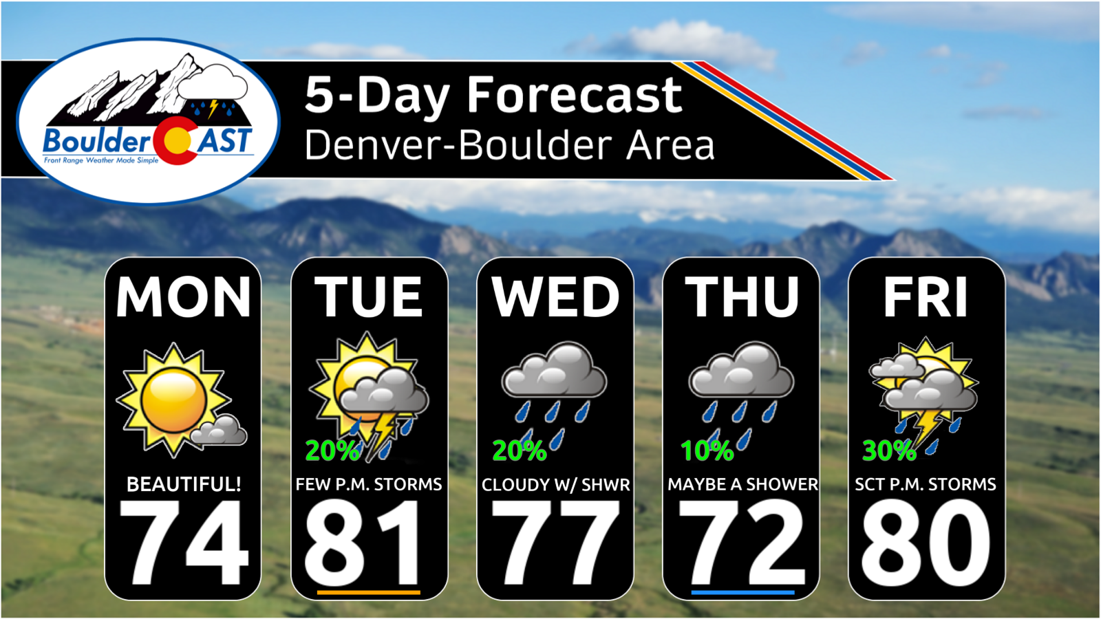
- ☀️ Monday is the gem — sunny, dry, and in the 70s; Tuesday brings moisture back to the High Country with gusty, weak storms possible in the Denver area.
- 💦 Midweek moisture surges (PWAT 160 to 260% of normal), but clouds and weak dynamics suppress meaningful rainfall again.
- 💧 Front Range rain totals stay low (<0.20″), while New Mexico faces major, state-wide flooding under deep subtropical moisture.
- 📈 Late week warms back above normal, with Friday potentially offering the best storm chance fueled by some sunshine (~30%).
- 🌀 Eastern Pacific hurricane basin extremely busy with Hurricanes Odalys & Polo likely undergoing Fujiwhara interaction this weekend — but long‑range implications for Colorado, if any, remain highly uncertain.
DISCLAIMER: This weekly outlook forecast is created Monday morning and covers the entire upcoming week. Accuracy will decrease as the week progresses as this post is NOT updated. To receive daily updated forecasts from our team, among many other perks, subscribe to BoulderCAST Premium.

Go Premium, get all the perks.
Daily Forecast Updates
Get our daily forecast discussion every morning delivered to your inbox.
All Our Model Data
Access to all our Colorado-centric high-resolution weather model graphics. Seriously — every one!
Ski & Hiking Forecasts
6-day forecasts for all the Colorado ski resorts, plus more than 120 hiking trails, including every 14er.
Smoke Forecasts
Wildfire smoke concentration predictions up to 72 hours into the future.
Exclusive Content
Weekend outlooks every Thursday, bonus storm updates, historical data and much more!
No Advertisements
Enjoy ad-free viewing on the entire site.
El Niño Keep the Monsoon Flowing… Just Not Here
Arapidly strengthening strong El Niño in the tropical Pacific has kept the North American Monsoon alive well into September — a month that normally marks the shutoff across the Front Range. And for much of the Four Corners, that expectation has absolutely verified: the monsoon has been relentless at times, delivering round after round of deep moisture and heavy rainfall over the past few weeks.
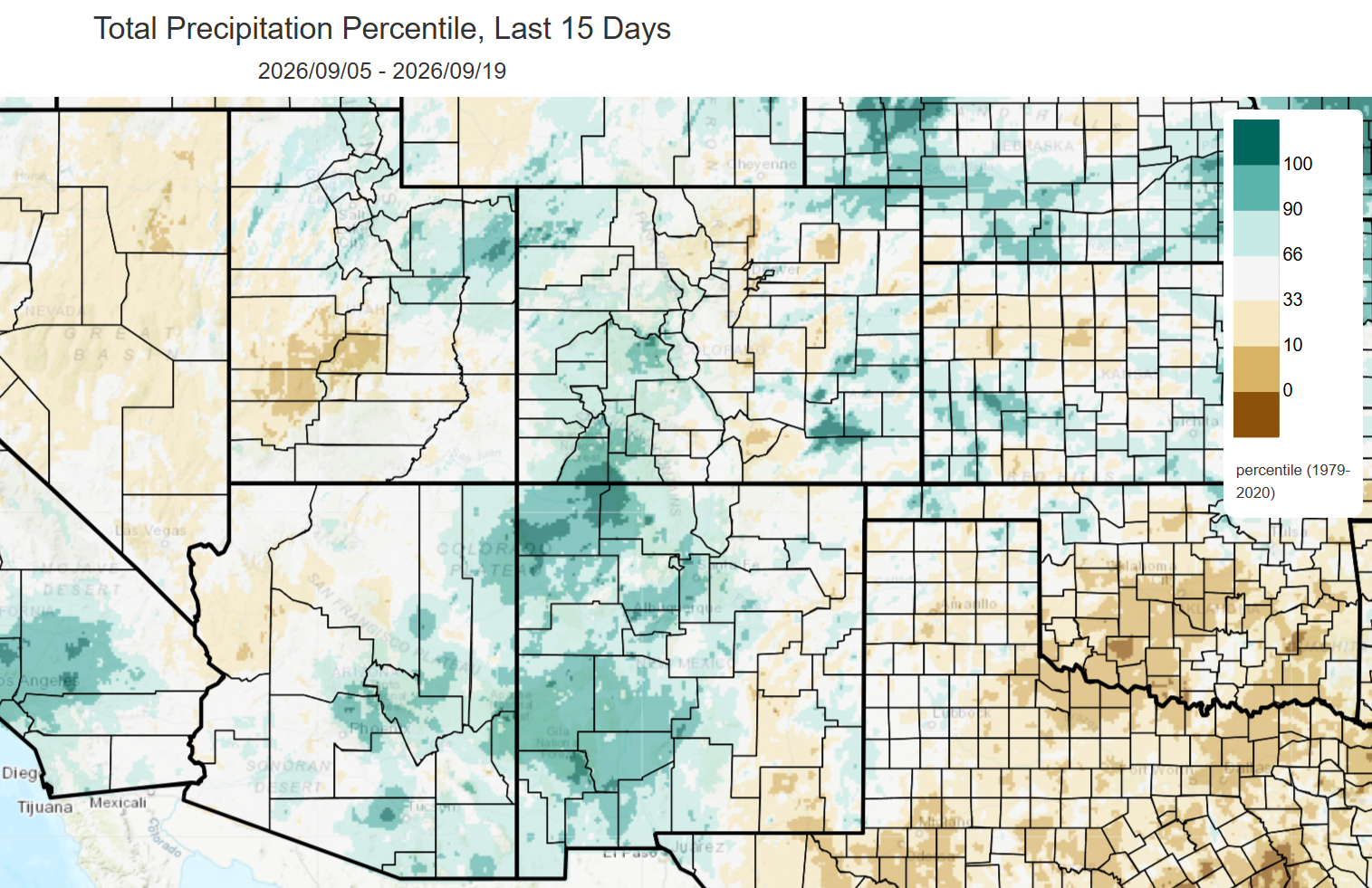
But Boulder? Boulder has been the stubborn exception. Month‑to‑date rainfall sits at 0.29″, a paltry 18% of normal, despite stormy skies being a near‑daily feature. We’ve logged more days with rain than without — 12 days with precipitation versus just 8 fully dry days — yet the atmosphere simply refuses to open up over the city. Denver has followed a similar trajectory, going 17 straight days without measurable rainfall to start September… until this past weekend, when a few thunderstorms dumped over an inch at DIA, instantly flipping the monthly totals above normal.
This Week: Continued Active Pattern, Continued Limited Payoff
The broader setup heading into the work week mirrors what we’ve seen all month (and really all summer): consistent late‑season monsoonal flow, but not much to actually show for it.
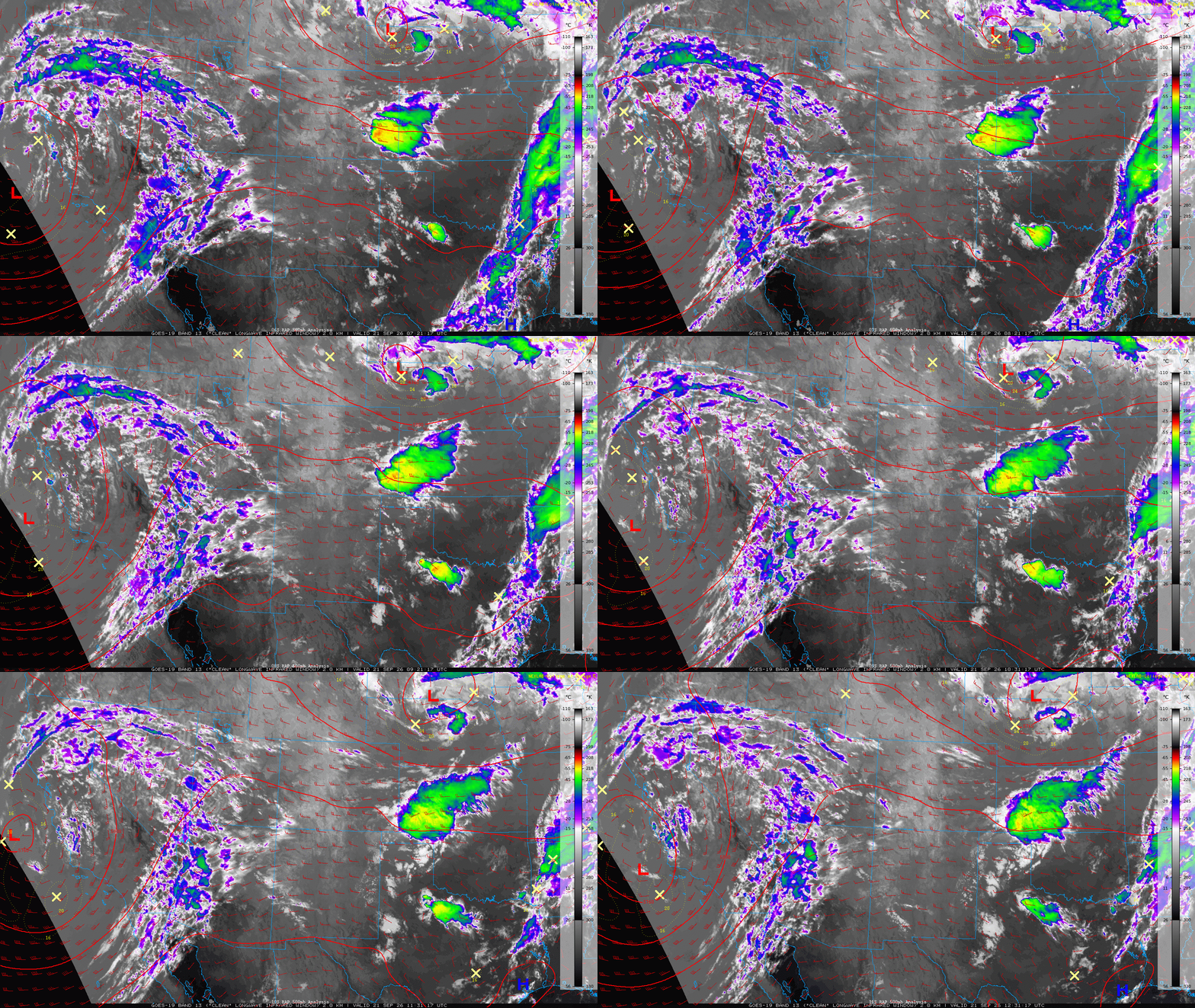
GOES-East infrared satellite imagery early on this Monday highlights the key players:
- Offshore California low — a compact closed low spinning just west of Los Angeles, pumping moisture northeast into the Desert Southwest.
- Northern Plains disturbance — sliding away from Colorado, offering no meaningful lift locally.
- Shortwave ridge over Colorado — delivering quiet skies and dry air to start the week.
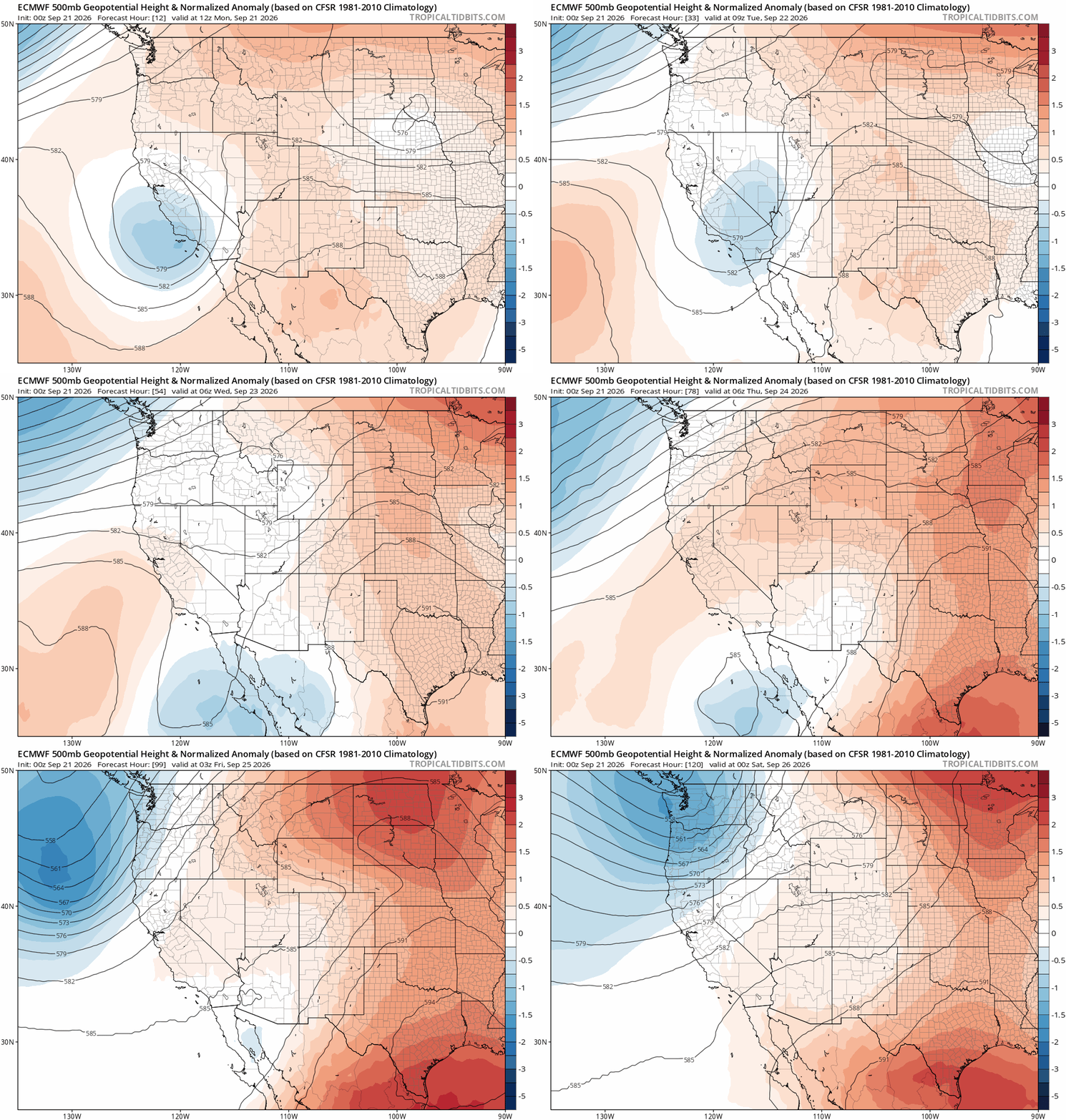
Through the work week ahead there will be very little change in the broader pattern across Colorado from day to day, with generally west to southwest flow present all week long while we reside under high pressure. The offshore low near California will fizzle early this week before ejecting northeast across Montana and Wyoming Tuesday night. As the week progresses, a strong area of high pressure will envelop the center of the nation, not succinctly over Denver but close enough to push our temperatures back above normal much of the time as we head into the late-week and weekend.
Quieter to Start the Week
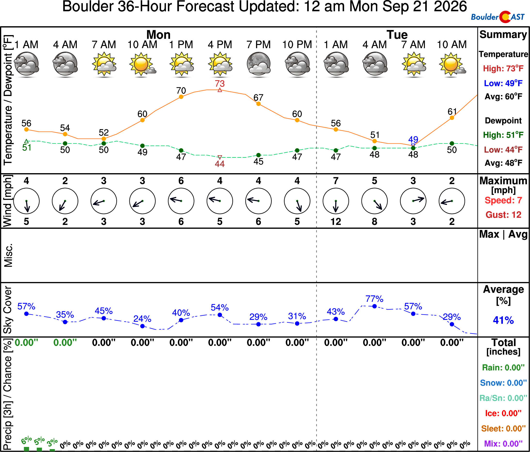
The initial shortwave ridge working in from the Great Basin will be directly overhead early in the week alongside very dry air blanketing the Mountains. This will lead to a quiet Monday statewide with dry conditions prevailing. Monday will be absolutely gorgeous in the Metro area, the coolest and nicest day of the week, with highs in the low to middle 70s and abundant sunshine.
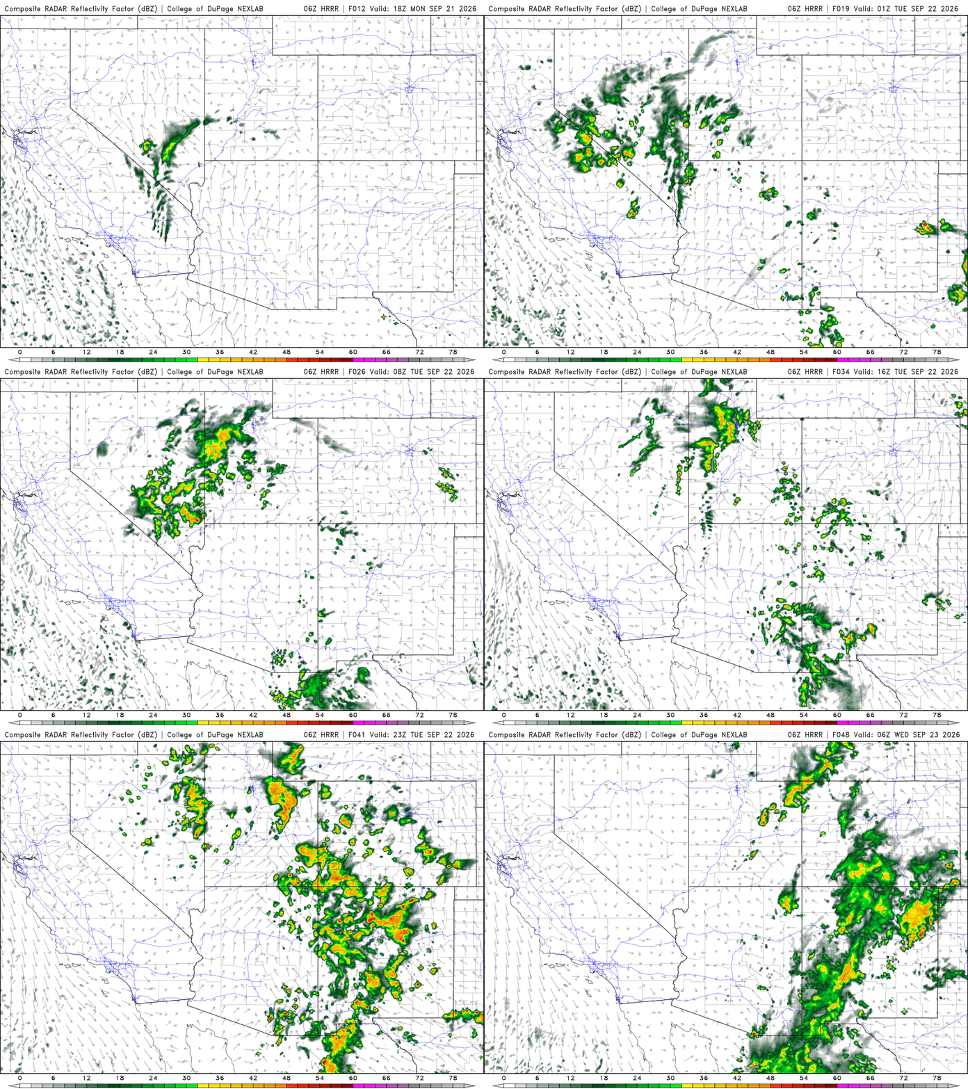
On Tuesday the ridge will begin to move east, with monsoon moisture returning to the Mountains as the dissipating California low ejects across the northern Rockies. Much of the High Country is in for a wet Tuesday and Tuesday night (especially the San Juans) with a potential for a few weak showers or storms to roll off the terrain into the Boulder-Denver area late in the day as well. Relatively dry surface air will favor gusty winds from these showers, rather than heavy downpours.
It will be a bit warmer Tuesday with highs close to 80°, with morning sun trending cloudier through the day with a slight chance of a weak late-day gusty storm.
Midweek: Moisture Surges, Rain Struggles
Wednesday and Thursday bring another impressive plume of subtropical moisture:
- Precipitable water (PWAT) reaches ~160% of normal for the second half of Wednesday
- PWAT then skyrockets to ~250% of normal Thursday
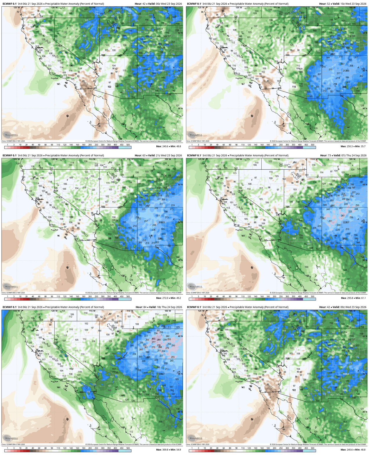
Similar to what we saw this past week, extensive cloud cover will greatly limit instability, while at the same time any embedded shortwaves will likely stay south of our area, meaning once again we’ll have near-record September moisture overhead but will be lacking any real lift to wring it out.
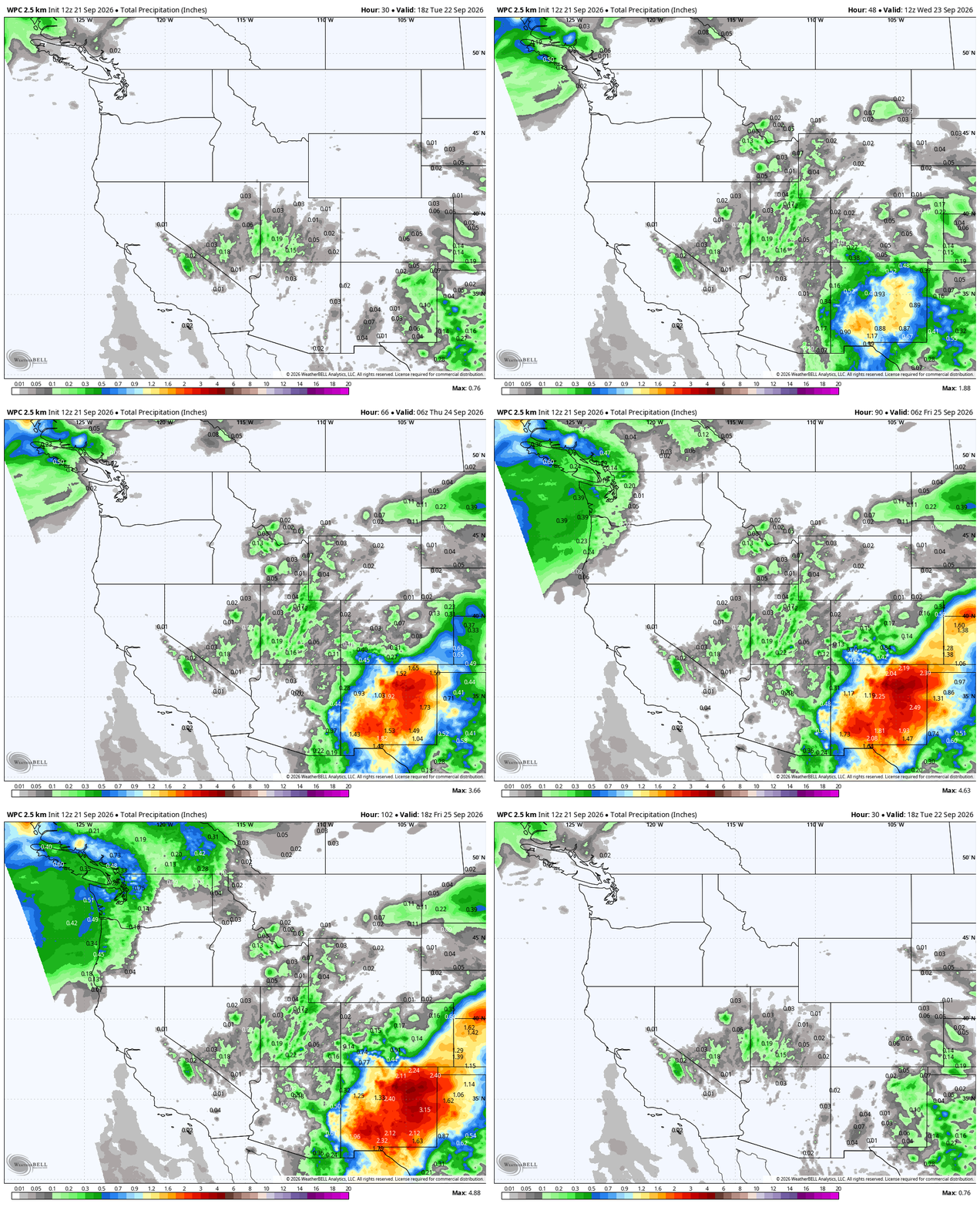
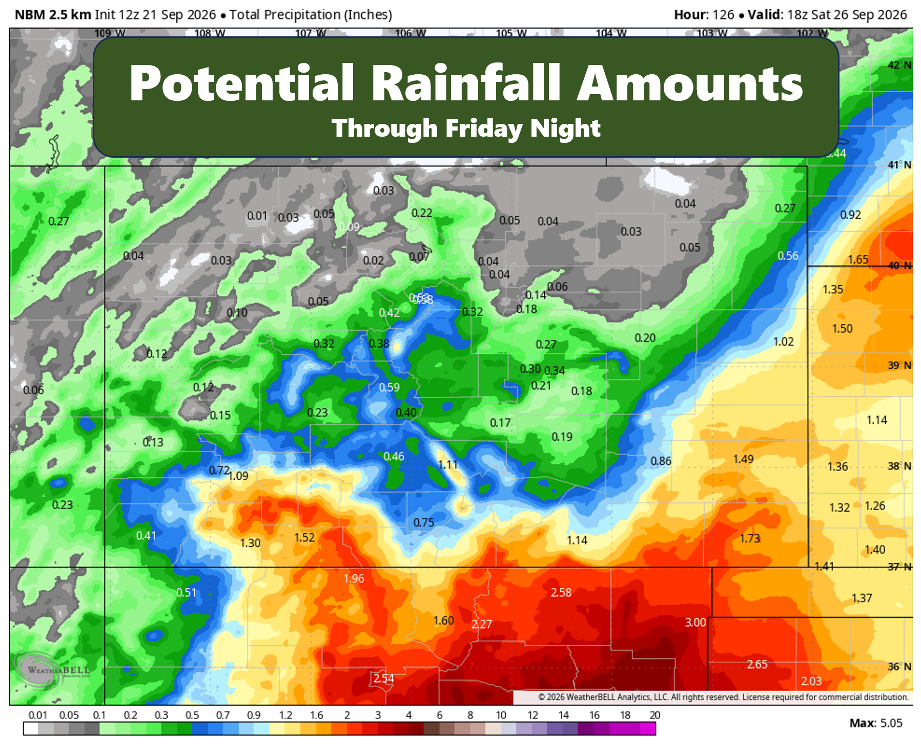
Overall this will frustratingly once again translate into limited rainfall potential for northern Colorado, with various towns in the Front Range battling it out for literal drops of moisture. Amounts under 0.2″ are favored, with the usual distribution also including a potentially completely dry week in spots and locally higher totals that land a lucky quick downpour.
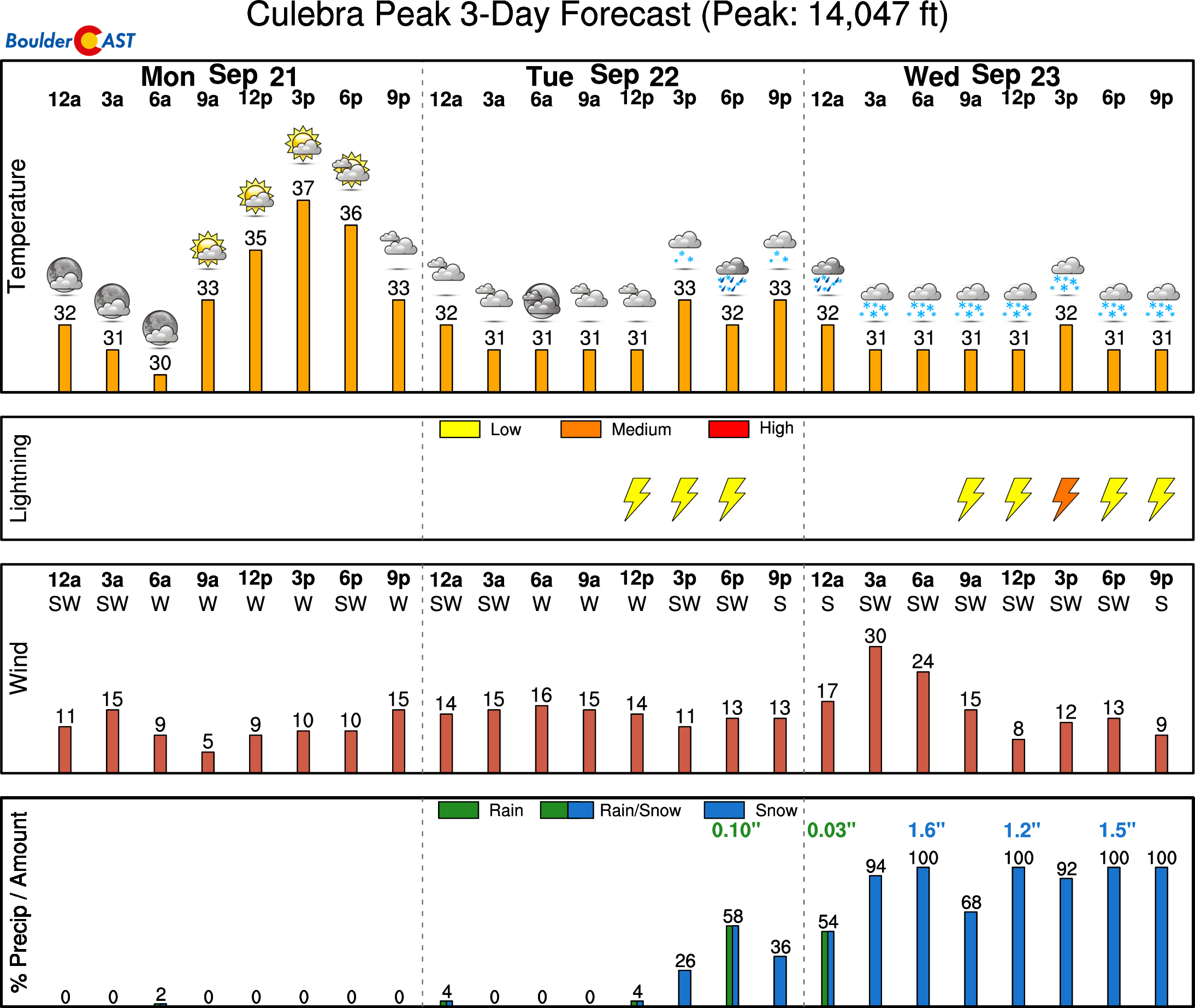
The highest peaks of the San Juans and Sangres will be cold enough to see a few inches of snow this week. Make sure to check our SummitCAST Mountain Forecast page if you are planning to bag any late-season 14ers. There will be snow!
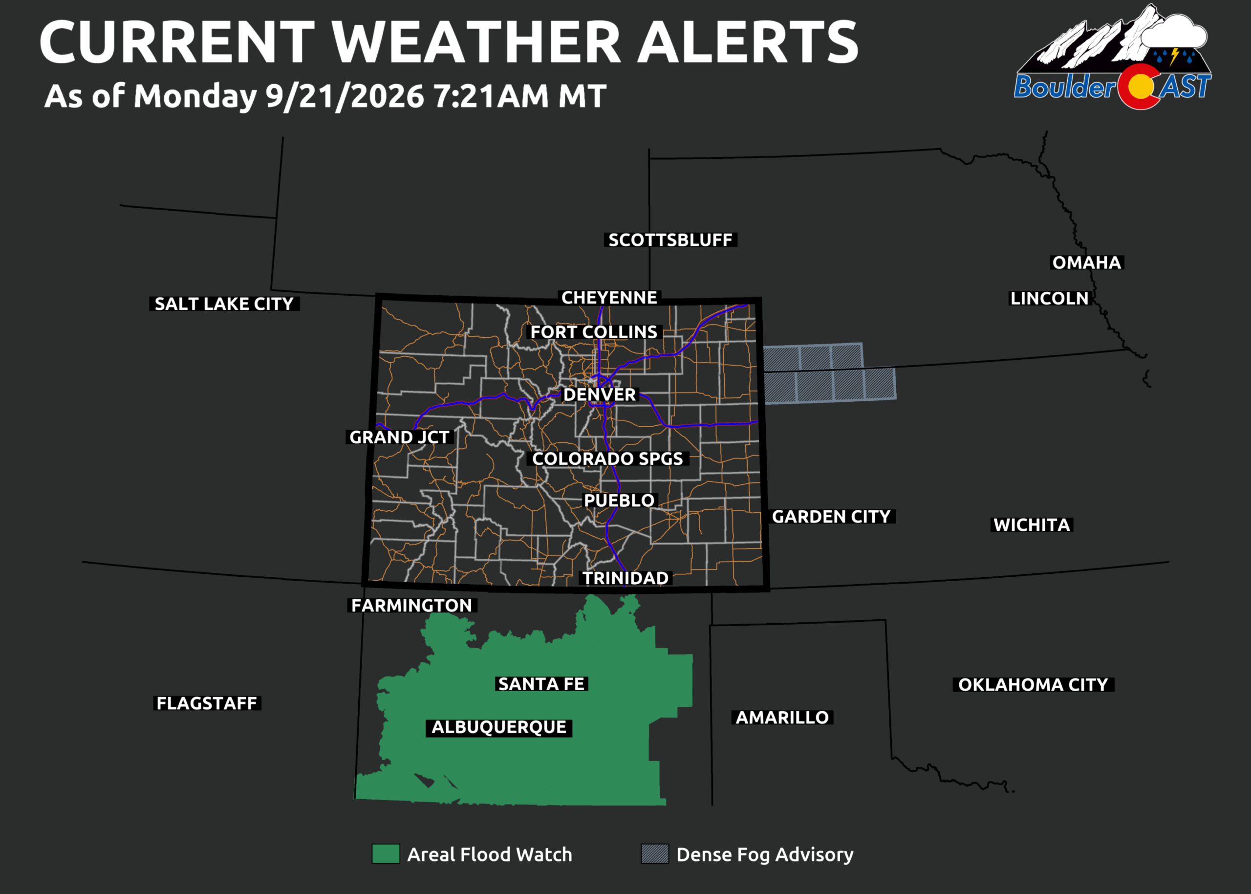
Meanwhile, even further to our south, it’s a completely different world. Flood Watches blanket New Mexico.
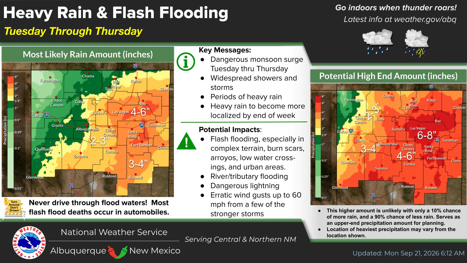
Shockingly, nearly the entire state is on-track to see more rain over the next few days than our area has seen all summer long. Latest forecasts call for a broad swath of 2 to 6 inches of rain, with the potential for up to 8 inches if wetter solutions verify. You will be hearing from the media about the flooding in New Mexico as the week progresses.
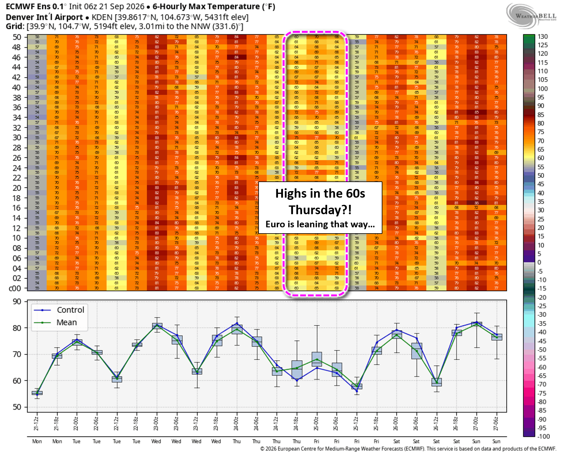
With so many clouds streaming into the area, and a weak cold front planned for Wednesday night or Thursday morning, high temperatures will fall back into the 70s these days. In fact, the European ensemble hints at some potential for highs not leaving the 60s on Thursday, though other modeling suites do keep us in the low to middle 70s.
Friday & Weekend: Warmer, Stormier
Temperatures will quickly warm up again above normal on Friday with a little more sunshine possible. Though moisture won’t be as high as prior days, there will still be plenty around to support scattered late-day storms cooked up by the early day sun. We’ll end the week with around a 30% chance of thunderstorms, which as of right now, could be our best chance of the week.
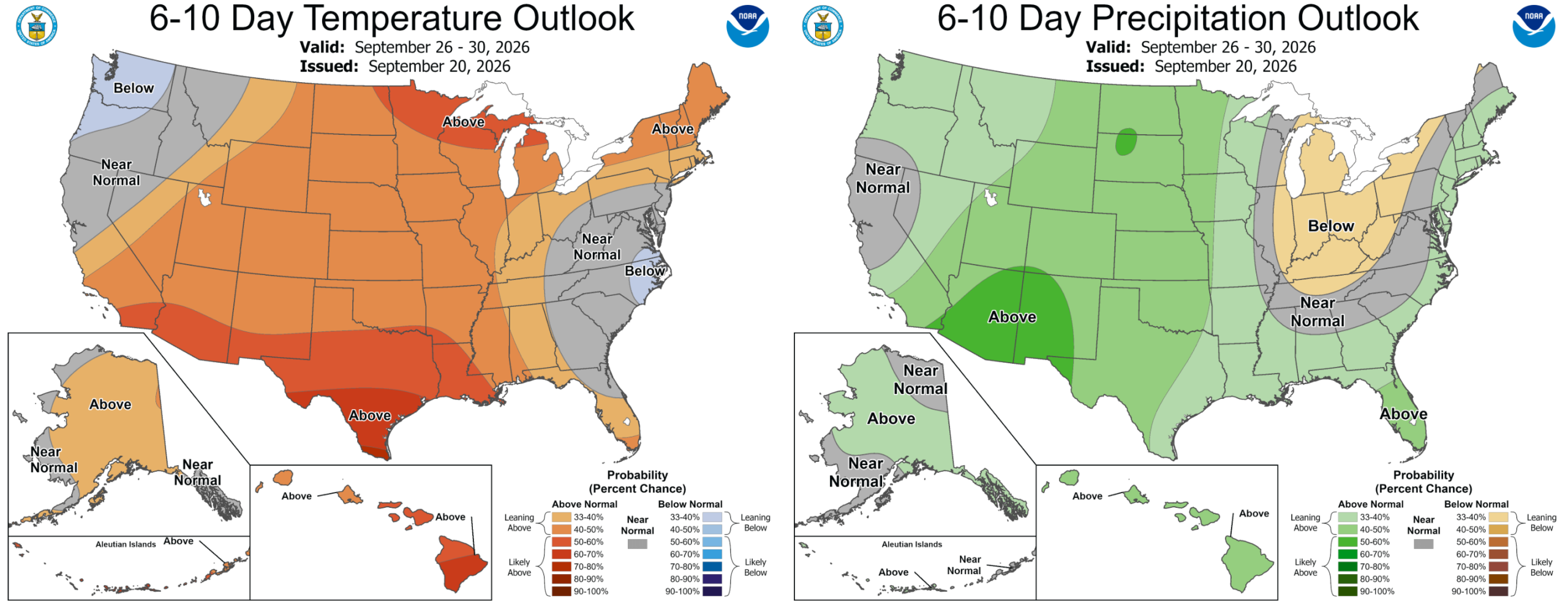
Subtropical moisture is expected to continue flowing into the Four Corners region at least through the weekend and possibly into early next week. This will favor above normal temperatures and precipitation chances in the extended for all of Colorado. In the Boulder-Denver area, scattered late-day thunderstorms will be around over the weekend with highs above normal in the low to middle 80s.
Watching the Tropics: A Wild Setup
El Niño’s historic strength is keeping the Eastern Pacific hurricane basin extremely active. There are currently two named storms — Odalys and Polo — plus two additional disturbances are poised to develop in the days ahead.
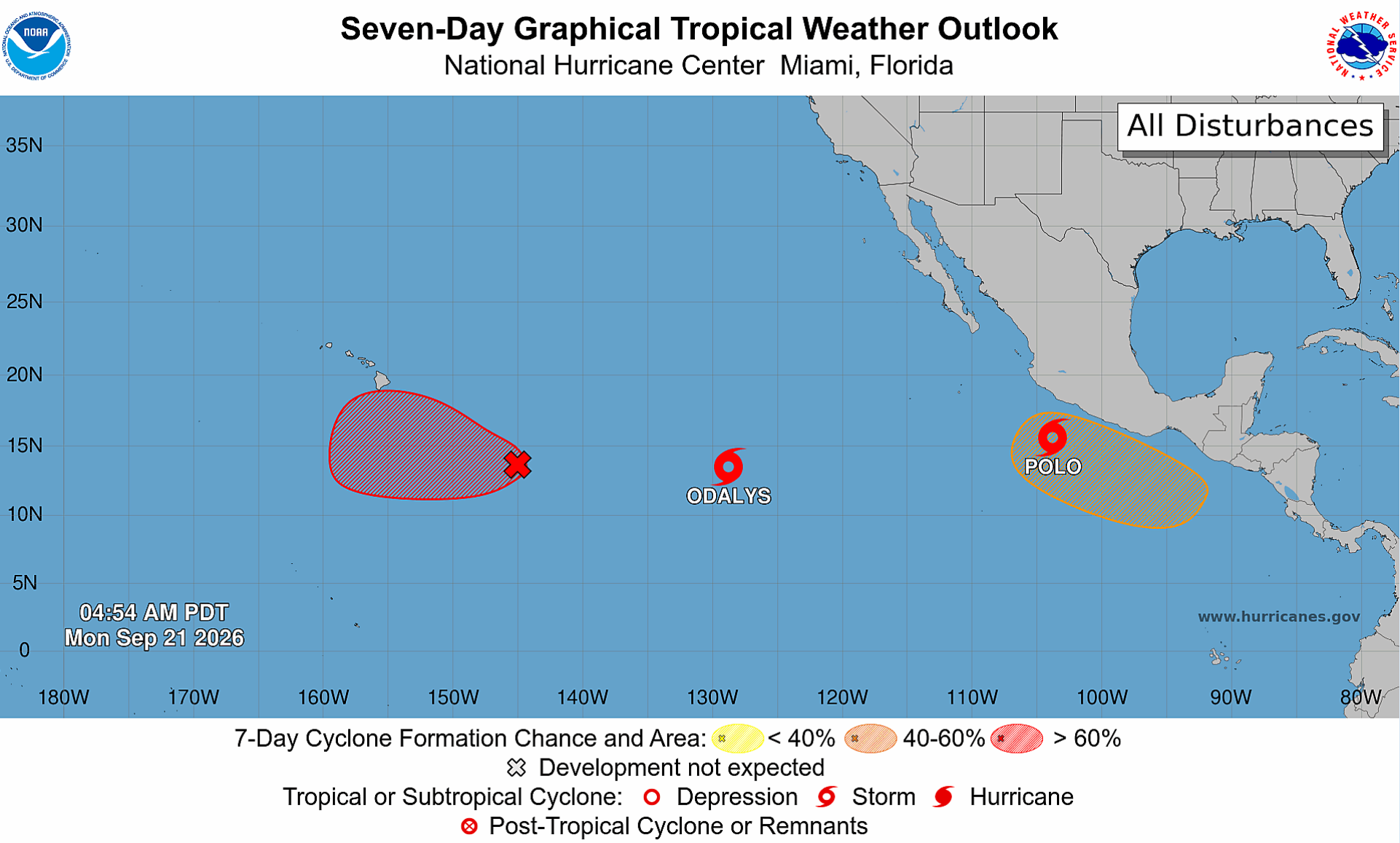
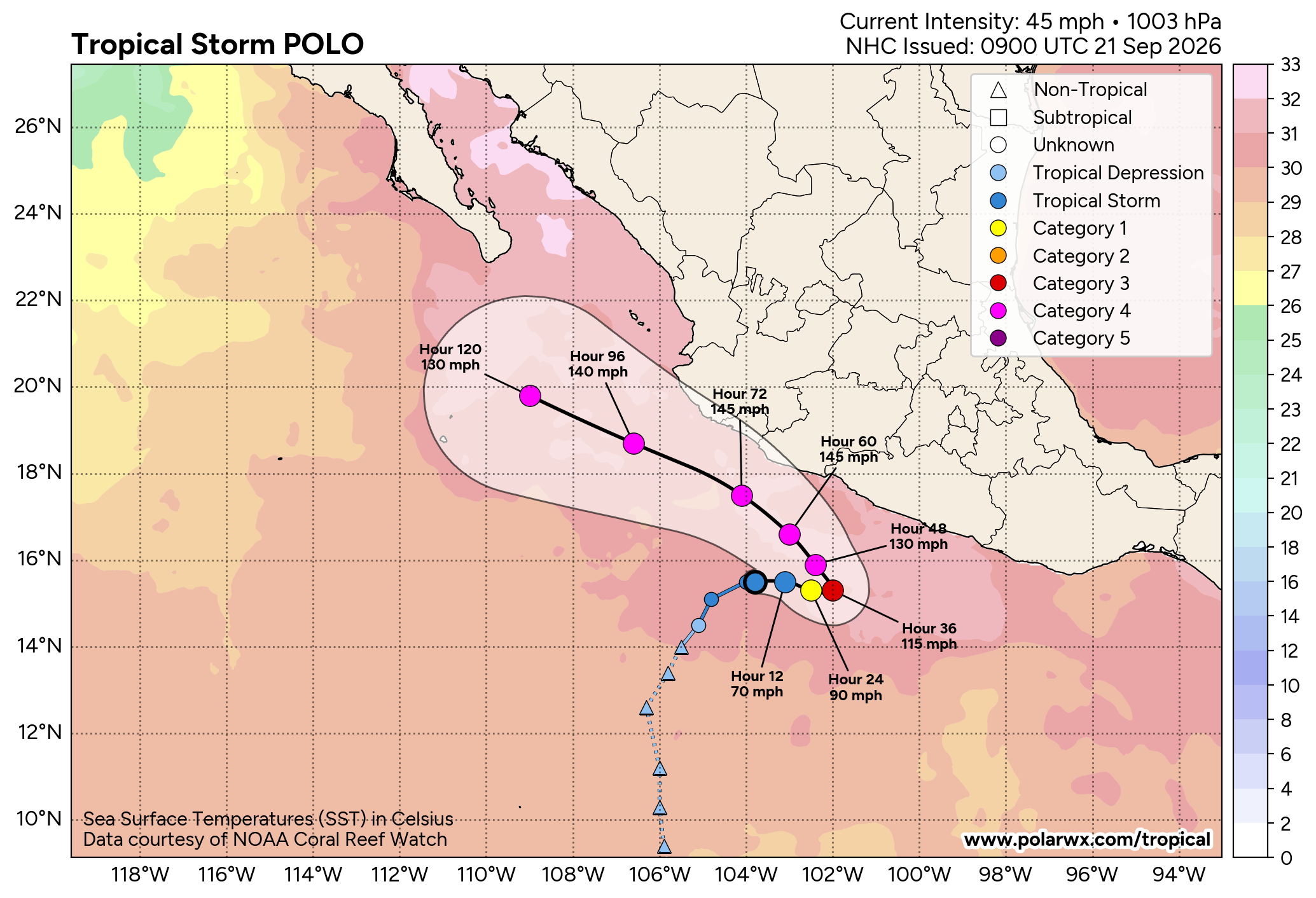
Odalys and Polo are both forecast to become hurricanes over the next 48 hours, with Polo the most dangerous as it skirts the Mexican coastline as a major hurricane around midweek. What a weird track!
As time goes on, the twin hurricanes will likely undergo Fujiwhara interactions this weekend, where the two tropical cyclones orbit one another.
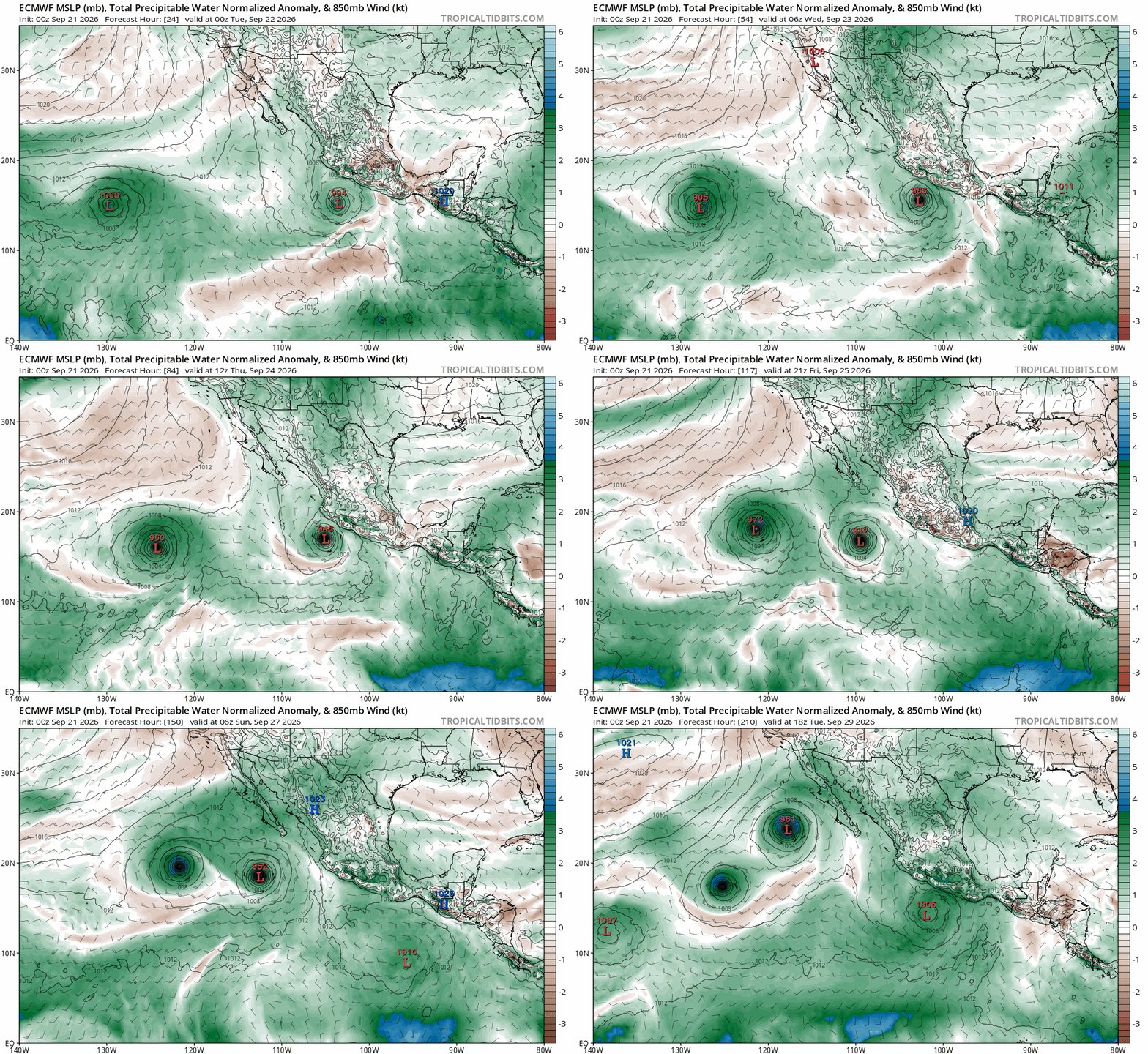
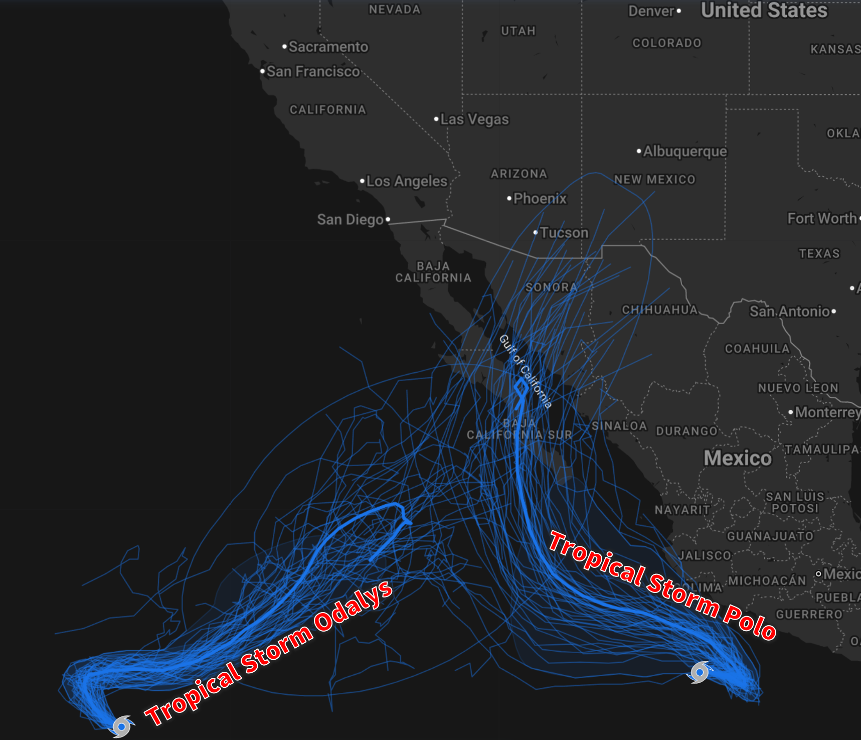
This interaction will lead to highly unpredictable tracks for the weekend into early next week. One outcome, and currently the slight favorite among ensembles, is that Polo recurves back into the Baja Peninsula, with its remnants then spreading into the American Southwest next week. That could keep monsoon moisture flowing into Colorado as the calendar flips to October… but it’s far too uncertain to lean on yet.
Happy first day of Fall (Tuesday)!

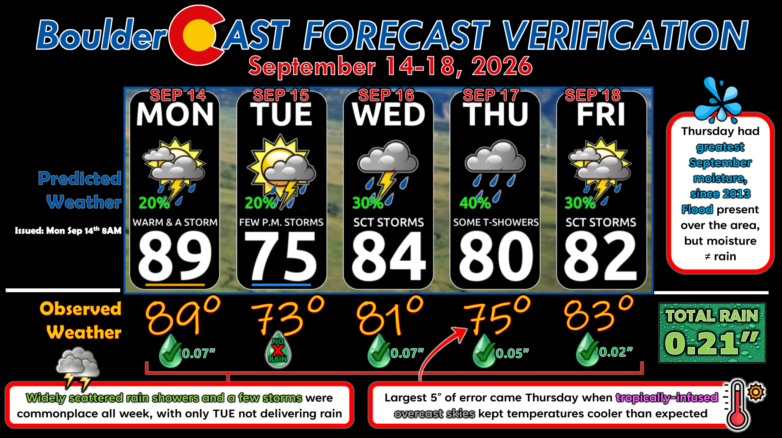
Forecast Verification: September 14-18, 2026 (Last Week)
- 4 days of rain totaling 0.21″
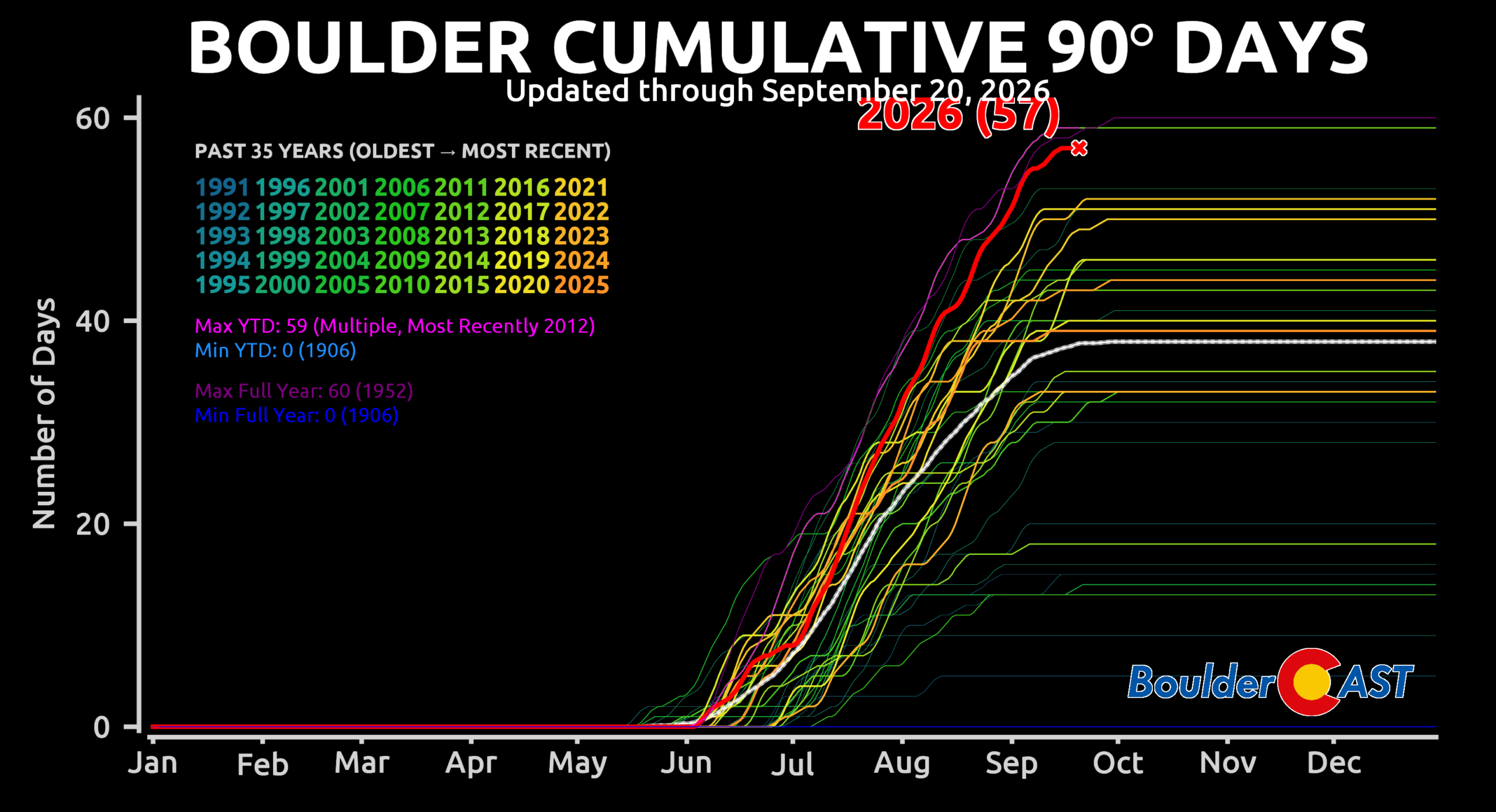
- No 90° days — Boulder sits at a count of 57 for the year, three shy of the all-time record (60, 1952)
- Thursday had extreme moisture content due to a tropical wave, but it didn’t rain much.
- Largest temperature error was 5° on Thursday when a thick, tropically-infused cloud deck capped temperatures.
- Otherwise, temperature forecasts were within 0 to 3° every other day.
DISCLAIMER: This weekly outlook forecast is created Monday morning and covers the entire upcoming week. Accuracy will decrease as the week progresses as this post is NOT updated. To receive daily updated forecasts from our team, among many other perks, subscribe to BoulderCAST Premium.
Go Premium, get all the perks.
Daily Forecast Updates
Get our daily forecast discussion every morning delivered to your inbox.
All Our Model Data
Access to all our Colorado-centric high-resolution weather model graphics. Seriously — every one!
Ski & Hiking Forecasts
6-day forecasts for all the Colorado ski resorts, plus more than 120 hiking trails, including every 14er.
Smoke Forecasts
Wildfire smoke concentration predictions up to 72 hours into the future.
Exclusive Content
Weekend outlooks every Thursday, bonus storm updates, historical data and much more!
No Advertisements
Enjoy ad-free viewing on the entire site.
Enjoy our content? Give it a share!











Leave a Reply
You must be logged in to post a comment.